| LA GRANDE/UNION COUNTY LA GRANDE OR |
| |
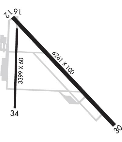
| Lat: N 4517.4 Long: W 11800.4 Elev: 2718 Var: -17 Longest Runway: 6261 | ||
| AWOS: 135.07 CTAF: 122.8 | ||
| |||||||||||||||||||||||||||||||||||||||||||||||||||||||||||||
| |||||||||||||||||||||||||||||||||||||||||||||||||||||||||||||
| |||||||||||||||||||||||||||||||||||||||||||||||||||||||||||||
| Rwy | Rwy | |||||||
| 6261x100 | 5501' | 6261x100 | 6261' | |||||
| 3399x60 | 3399' | 3399x60 | 3399' | |||||
| Runway ID | Single Wheel | Double Wheel | Double Tandem Wheel | Dual Double Wheel |
| 12/30 | 65,000 | 90,000 | 130,000 | N/A |
| 17/35 | 45,000 | 60,000 | 100,000 | N/A |
| These numbers are Advisory and are not limits. The Airport Manager should have more accurate Weight Limits | ||||
 Airport Diagram might not be current. | |
| Facility Name: | LA GRANDE/UNION COUNTY |
| City Name: | LA GRANDE |
| County: | UNION |
| State abbrev: | OR |
| State Name: | OREGON |
| Ownership: | PUBLICLY OWNED |
| Use: | OPEN TO THE PUBLIC |
| Owner's Name: | UNION COUNTY |
| Address: | 1106 K AVENUE |
| LA GRANDE, OR 97850 | |
| Owner's Phone: | 514-963-1016 |
| Manager's Name: | DOUG WRIGHT |
| Address: | 60175 PIERCE ROAD |
| LA GRANDE, OR 97850 | |
| Phone: | 541-963-6615 |
| FAA Region: | NORTHWEST MOUNTAIN |
| FAA Field Office: | SEA |

| Date | Sunrise | Sunset |
|---|---|---|
| 09/24/21 Friday | 6:41 | 18:46 |
| 09/25/21 Saturday | 6:43 | 18:44 |
| 09/26/21 Sunday | 6:44 | 18:42 |
| 09/27/21 Monday | 6:45 | 18:40 |
| 09/28/21 Tuesday | 6:46 | 18:38 |
| 09/29/21 Wednesday | 6:47 | 18:36 |
| 09/30/21 Thursday | 6:49 | 18:35 |
| 10/01/21 Friday | 6:50 | 18:33 |
| 10/02/21 Saturday | 6:51 | 18:31 |
| 10/03/21 Sunday | 6:52 | 18:29 |
| 10/04/21 Monday | 6:54 | 18:27 |
| 10/05/21 Tuesday | 6:55 | 18:25 |
| 10/06/21 Wednesday | 6:56 | 18:23 |
| 10/07/21 Thursday | 6:58 | 18:21 |
| Airport Attendance Schedule | 7 Days A Week 0800-1700; CLOSED THANKSGIVING, CHRISTMAS AND NEW YEARS. |
| Airport Status | OPERATIONAL (This Status can change at any time - please check NOTAMS) |
| Airport Lighting Schedule | ACTIVATE MIRL RWY 12/30 & 17/35 - CTAF. |
| Airport Storage Available | Tie Downs, Hanger |
| Extra Services Available | Crop Dusting, Air Ambulance, Flight Instruction |
| Wind Indicator | YES - (lighted) |
| Control Tower | NO |
| CTAF Frequency | 122.800 |
| Unicom Frequency | 122.800 |
| Rotating Beacon Color | CLEAR-GREEN (Light Land Airport) |
| Segmented Circle | YES; SEGMENTED CIRCLE MARKED IN WHITE ONLY |
| Landing Fee | YES; OVER 12500 LBS. |
| Airport Inspected | STATE - performed by STATE AERONAUTICAL PERSONNEL |
| Inspection Date | 08/28/2018 |
| Type of Fuel Available | Grade 100LL, JET A (freeze point -40C) |
| Airframe Repair Service | MAJOR |
| Power Plant Repair Service | MAJOR |
| Latitude | N4517.4 |
| Longitude | W11800.4 (ESTIMATED) |
| Arpt Elevation | 2717ft (SURVEYED) |
| Magnetic Variation | 17E |
| 4 miles SE | of LA GRANDE |
| Traffic Pattern Altitude | |
| Sectional Chart | SEATTLE |
| Operations (Reported) | Yearly | Avg. Daily |
|---|---|---|
| General Aviation Transient | 9000 | 25 |
| General Aviation Local | 4000 | 11 |
| Air Taxi | 2500 | 7 |
| Commerical | 0 | 0 |
| Commuter | 0 | 0 |
| Military | 500 | 1 |
| Aircraft based on Field | |
|---|---|
| General Aviation Singles | 44 |
| General Aviation Multi | 3 |
| Jet Aircraft | 0 |
| General Aviation Helicopters | 4 |
| Military Aircraft | 0 |
| Gliders | 0 |
| Ultralights | 0 |
| FSS on field | NO |
| FSS tie-in | MC MINNVILLE |
| FSS Phone | 1-800-WX-BRIEF |
| Who issues Notams | LGD |
| Notam D service at airport | YES |
| ARTCC Name | SEATTLE |
| Airport Certification | |
| Aircraft Rescue & Firefighting Index | None |
| Airport of Entry | No |
| Custom Landing Rights | No |
| Joint Civil/Military | No |
| Military Landing rights | YES |
| NATIONAL PLAN OF INTEGRATED AIRPORT SYSTEMS (NPIAS) |
| GRANT AGREEMENTS UNDER FAAP/ADAP/AIP |
| ASSURANCES PURSUANT TO TITLE VI, CIVIL RIGHTS ACT OF 1964 |
| AGREEMENT UNDER DLAND OR DCLA HAS EXPIRED. |
| EXTSV FOREST SVC OPNS DURG SUMMER MOS. |
| FBO & FUELING LCTD WEST OF RWY 17/35 |
| COLD TEMPERATURE RESTRICTED AIRPORT. ALTITUDE CORRECTION REQUIRED AT OR BELOW -16C. |
| FOR CD IF UNA TO CTC ON FSS FREQ, CTC SEATTLE ARTCC AT 253-351-3694. |
Airport Communications & Frequencies:
| |||||||||
| Runway: 12 | Runway: 30 | ||
| Mag heading: | 118° | Mag heading: | 298° |
| Rwy Slope: | -.17% Down | Rwy Slope: | .17% Up |
| Approach: | Approach: | ||
| Pattern: | Left Traffic | Pattern: | Left Traffic |
| Markings: | NONPRECISION INSTRUMENT | Markings: | NONPRECISION INSTRUMENT |
| Marking Condition: | GOOD | Marking Condition: | GOOD |
| Arresting Dev: | Arresting Dev: | ||
| Lat & Long: | N4517.7 W11800.7 | Lat. & Long.: | N4517.0 W11759.7 |
| Elev: | 2717.6 ft. MSL | Elev: | 2706.8 ft. MSL |
| TCH: | 44 ft. AGL | TCH: | 44 ft. AGL |
| Visual Glide Path: | 3.00 degrees | Visual Glide Path: | 3.00 degrees |
| Displaced Threshold: | 760 feet | Displaced Threshold: | No |
| Touchdown Zone: | YES | Touchdown Zone: | YES |
| Touchdown Elev.: | 2714.2 feet | Touchdown Elev.: | 2709.8 feet |
| Visual Glide Slope: | 2-Light PAPI on LEFT side of Runway | Visual Glide Slope: | 2-Light PAPI on LEFT side of Runway |
| RVR Equipment: | RVR Equipment: | ||
| RVV Equipment: | NO | RVV Equipment: | NO |
| Approach Lights: | Approach Lights: | ||
| REIL: | NO | REIL: | YES |
| Centerline Lights: | NO | Centerline Lights: | NO |
| Touchdown lights: | NO | Touchdown lights: | NO |
| Runway Category: | Runway with a Visual Approach | Runway Category: | Runway with a Visual Approach |
| Declared Distances: | TORA:6260' TODA:6260' | Declared Distances: | TORA:6260' TODA:6260' |
| Obstructions: | ROAD | Obstructions: | |
| Marked: | NOT Marked/Lighted | Marked: | |
| Clearance slope: | 9:1; RUNWAY 12 OBSTRUCTION CLEARANCE SLOPE 72:1 BASED ON DISPLACED THRESHOLD | Clearance slope: | 50:1 |
| Obstruction height: | 15 feet AGL | Obstruction height: | |
| Dist. from runway: | 335 feet | Dist. from runway: | |
| Centerline offset: | Centerline offset: | ||
| Comments: | Comments: |
| Runway: 17 | Runway: 35 | ||
| Mag heading: | 163° | Mag heading: | 343° |
| Rwy Slope: | -.15% Down | Rwy Slope: | .15% Up |
| Approach: | Approach: | ||
| Pattern: | Left Traffic | Pattern: | Left Traffic |
| Markings: | NONPRECISION INSTRUMENT | Markings: | NONPRECISION INSTRUMENT |
| Marking Condition: | GOOD | Marking Condition: | GOOD |
| Arresting Dev: | Arresting Dev: | ||
| Lat & Long: | N4517.7 W11800.7 | Lat. & Long.: | N4517.1 W11800.7 |
| Elev: | 2714.6 ft. MSL | Elev: | 2709.5 ft. MSL |
| TCH: | 33 ft. AGL | TCH: | |
| Visual Glide Path: | 3.00 degrees | Visual Glide Path: | |
| Displaced Threshold: | No | Displaced Threshold: | No |
| Touchdown Zone: | YES | Touchdown Zone: | YES |
| Touchdown Elev.: | 2714.6 feet | Touchdown Elev.: | 2713.8 feet |
| Visual Glide Slope: | 4-Light PAPI on LEFT side of Runway | Visual Glide Slope: | |
| RVR Equipment: | RVR Equipment: | ||
| RVV Equipment: | NO | RVV Equipment: | NO |
| Approach Lights: | Approach Lights: | ||
| REIL: | NO | REIL: | NO |
| Centerline Lights: | NO | Centerline Lights: | NO |
| Touchdown lights: | NO | Touchdown lights: | NO |
| Runway Category: | Runway Category: | Runway with a Visual Approach | |
| Declared Distances: | Declared Distances: |
Thanks for using FltPlan.com
all rights reserved © 1999-2021 by Flight Plan LLC