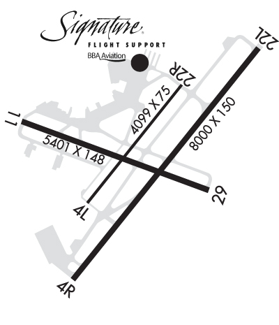
Runway Identification: 04L/22RLength: 4099 ft
Width: 75 ft
Surface: ASPHALT-FAIR CONDITION
Edge lights: Medium IntensityWeight: PCN 11 /F/D/X/T
| | Runway: 04L | | Runway: 22R |
| Mag heading: | 36° | Mag heading: | 216° |
| Rwy Slope: | .01% Up | Rwy Slope: | -.01% Down |
| Approach: | | Approach: | |
| Pattern: | Left Traffic | Pattern: | Right Traffic |
| Markings: | NONPRECISION INSTRUMENT | Markings: | NONPRECISION INSTRUMENT |
| Marking Condition: | FAIR | Marking Condition: | FAIR |
| Arresting Dev: | | Arresting Dev: | |
| Lat & Long: | N3012.1 W09159.6 | Lat. & Long.: | N3012.6 W09159.1 |
| Elev: | 41.2 ft. MSL | Elev: | 41.6 ft. MSL |
| TCH: | 26 ft. AGL | TCH: | 26 ft. AGL |
| Visual Glide Path: | 3.00 degrees | Visual Glide Path: | 3.00 degrees |
| Displaced Threshold: | No | Displaced Threshold: | No |
| Touchdown Zone: | YES | Touchdown Zone: | YES |
| Touchdown Elev.: | 41.6 feet | Touchdown Elev.: | 41.7 feet |
| Visual Glide Slope: | 2-Light PAPI on LEFT side of Runway | Visual Glide Slope: | 2-Light PAPI on LEFT side of Runway |
| RVR Equipment: | | RVR Equipment: | |
| RVV Equipment: | NO | RVV Equipment: | NO |
| Approach Lights: | | Approach Lights: | |
| REIL: | YES | REIL: | YES |
| Centerline Lights: | NO | Centerline Lights: | NO |
| Touchdown lights: | NO | Touchdown lights: | NO |
| Runway Category: | Runway with a Visual Approach | Runway Category: | Runway with a Visual Approach |
| Declared Distances: | TORA:4099' TODA:4099' ASDA:4099' LDA:4099' | Declared Distances: | TORA:4099' TODA:4099' ASDA:4099' LDA:4099' |
| Obstructions: | TREE | Obstructions: | TREE |
| Marked: | NOT Marked/Lighted | Marked: | NOT Marked/Lighted |
| Clearance slope: | 29:1 | Clearance slope: | 40:1 |
| Obstruction height: | 27 feet AGL | Obstruction height: | 54 feet AGL |
| Dist. from runway: | 996 feet | Dist. from runway: | 2364 feet |
| Centerline offset: | 83 left of centerline | Centerline offset: | 5 feet right of centerline |
| Comments: | | Comments: | |
Runway Identification: 04R/22LLength: 8000 ft
Width: 150 ft
Surface: ASPHALT-GOOD CONDITION
Edge lights: High IntensityTreatment: GROOVED
Weight: PCN 67 /F/C/X/T
| | Runway: 04R | | Runway: 22L |
| Mag heading: | 36° | Mag heading: | 216° |
| Rwy Slope: | -.08% Down | Rwy Slope: | .08% Up |
| Approach: | ILS/DME | Approach: | ILS/DME |
| Pattern: | Right Traffic | Pattern: | Left Traffic |
| Markings: | PRECISION INSTRUMENT | Markings: | PRECISION INSTRUMENT |
| Marking Condition: | GOOD | Marking Condition: | GOOD |
| Arresting Dev: | EMAS; ENGINEERED MATERIALS ARRESTING SYSTEM (EMAS) 223 FT IN LENGTH BY 170 FT IN WIDTH LCTD AT THE DER 04R. | Arresting Dev: | EMAS; ENGINEERED MATERIALS ARRESTING SYSTEM (EMAS) 380.67 FT IN LENGTH BY 170 FT IN WIDTH LCTD AT THE DER 22L. |
| Lat & Long: | N3011.8 W09159.6 | Lat. & Long.: | N3012.8 W09158.7 |
| Elev: | 39.1 ft. MSL | Elev: | 32.7 ft. MSL |
| TCH: | 50 ft. AGL | TCH: | 50 ft. AGL |
| Visual Glide Path: | 3.00 degrees | Visual Glide Path: | 3.00 degrees |
| Displaced Threshold: | No | Displaced Threshold: | 342 feet |
| Touchdown Zone: | YES | Touchdown Zone: | YES |
| Touchdown Elev.: | 39.5 feet | Touchdown Elev.: | 37.9 feet |
| Visual Glide Slope: | 4-Light PAPI on LEFT side of Runway | Visual Glide Slope: | 4-Light PAPI on LEFT side of Runway |
| RVR Equipment: | ROLLOUT | RVR Equipment: | TOUCHDOWN |
| RVV Equipment: | NO | RVV Equipment: | NO |
| Approach Lights: | | Approach Lights: | MALSR - 1,400 foot medium intensity approach lighting system with runway alignment indicator lights |
| REIL: | YES | REIL: | NO |
| Centerline Lights: | NO | Centerline Lights: | NO |
| Touchdown lights: | NO | Touchdown lights: | NO |
| Runway Category: | Precision Instrument Runway | Runway Category: | Precision Instrument Runway |
| Declared Distances: | TORA:8001' TODA:8001' ASDA:8001' LDA:8001' | Declared Distances: | TORA:8001' TODA:8001' ASDA:8001' LDA:7659' |
| Obstructions: | POLE | Obstructions: | TREES |
| Marked: | NOT Marked/Lighted | Marked: | NOT Marked/Lighted |
| Clearance slope: | 34:1 | Clearance slope: | 36:1 |
| Obstruction height: | 49 feet AGL | Obstruction height: | 57 feet AGL |
| Dist. from runway: | 1843 feet | Dist. from runway: | 1066 feet |
| Centerline offset: | 325 right of centerline | Centerline offset: | 214 feet right of centerline |
| Comments: | | Comments: | |
Runway Identification: 11/29Length: 5400 ft
Width: 148 ft
Surface: ASPHALT-GOOD CONDITION
Edge lights: Medium IntensityTreatment: GROOVED
Weight: PCN 5 /F/D/X/T
| | Runway: 11 | | Runway: 29 |
| Mag heading: | 107° | Mag heading: | 287° |
| Rwy Slope: | -.04% Down | Rwy Slope: | .04% Up |
| Approach: | | Approach: | |
| Pattern: | Right Traffic | Pattern: | Left Traffic |
| Markings: | NONPRECISION INSTRUMENT | Markings: | NONPRECISION INSTRUMENT |
| Marking Condition: | GOOD | Marking Condition: | GOOD |
| Arresting Dev: | | Arresting Dev: | EMAS; ENGINEERED MATERIALS ARRESTING SYSTEM (EMAS) APRX 170 FT WIDE AND 448 FT LONG LCTD AT THE DER 29. |
| Lat & Long: | N3012.5 W09159.9 | Lat. & Long.: | N3012.2 W09158.9 |
| Elev: | 37.0 ft. MSL | Elev: | 34.9 ft. MSL |
| TCH: | 36 ft. AGL | TCH: | 51 ft. AGL |
| Visual Glide Path: | 3.00 degrees | Visual Glide Path: | 3.00 degrees |
| Displaced Threshold: | No | Displaced Threshold: | 250 feet |
| Touchdown Zone: | YES | Touchdown Zone: | YES |
| Touchdown Elev.: | 41.6 feet | Touchdown Elev.: | 41.6 feet |
| Visual Glide Slope: | 4-Light PAPI on LEFT side of Runway | Visual Glide Slope: | 4-Light PAPI on LEFT side of Runway |
| RVR Equipment: | | RVR Equipment: | |
| RVV Equipment: | NO | RVV Equipment: | NO |
| Approach Lights: | | Approach Lights: | |
| REIL: | YES | REIL: | YES |
| Centerline Lights: | NO | Centerline Lights: | NO |
| Touchdown lights: | NO | Touchdown lights: | NO |
| Runway Category: | Runway with a Non-precision Approach having visibility minimums greater than 3/4 mile | Runway Category: | Runway with a Non-precision Approach having visibility minimums greater than 3/4 mile |
| Declared Distances: | TORA:5401' TODA:5401' ASDA:5401' LDA:5401' | Declared Distances: | TORA:5401' TODA:5401' ASDA:5401' LDA:5401' |
| Obstructions: | TREES | Obstructions: | TREE |
| Marked: | NOT Marked/Lighted | Marked: | NOT Marked/Lighted |
| Clearance slope: | 29:1 | Clearance slope: | 34:1 |
| Obstruction height: | 30 feet AGL | Obstruction height: | 49 feet AGL |
| Dist. from runway: | 1082 feet | Dist. from runway: | 1878 feet |
| Centerline offset: | 134 right of centerline | Centerline offset: | 302 feet right of centerline |
| Comments: | | Comments: | |
Runway Identification: H1 HELIPADLength: 50 ft
Width: 50 ft
Surface: ASPHALT-FAIR CONDITION
Edge lights: PERI