
| AUBURN/LEWISTON MUNI AUBURN/LEWISTON ME |
| |
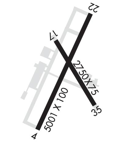
| Lat: N 4402.9 Long: W 07017.0 Elev: 288 Var: +17 Longest Runway: 5001 | ||
| Clr Del: 124.05 AWOS: 118.02 CTAF: 122.8 | ||
| ||||||||||||||||||||||||||||||||||||||||||||
| ||||||||||||||||||||||||||||||||||||||||||||
| ||||||||||||||||||||||||||||||||||||||||||||
| Rwy | Rwy | |||||||
| 5001x100 | 5001' | 108.90 - 041° | 5001x100 | 5001' | ||||
| 2750x75 | 2750' | 2750x75 | 2750' | |||||
| Runway ID | Single Wheel | Double Wheel | Double Tandem Wheel | Dual Double Wheel |
| 04/22 | 30,000 | 108,000 | 180,000 | N/A |
| 17/35 | 30,000 | N/A | N/A | N/A |
| These numbers are Advisory and are not limits. The Airport Manager should have more accurate Weight Limits | ||||
 Airport Diagram might not be current. | |
| Facility Name: | AUBURN/LEWISTON MUNI |
| City Name: | AUBURN/LEWISTON |
| County: | ANDROSCOGGIN |
| State abbrev: | ME |
| State Name: | MAINE |
| Ownership: | PUBLICLY OWNED |
| Use: | OPEN TO THE PUBLIC |
| Owner's Name: | CITIES OF AUBURN & LEWISTON |
| Address: | 80 AIRPORT DR |
| AUBURN, ME 04210 | |
| Owner's Phone: | 207-786-0631 |
| Manager's Name: | JONATHAN LABONTE; AUBURN CITY TRANSPORTATION DIR. |
| Address: | 80 AIRPORT DR |
| AUBURN, ME 04210 | |
| Phone: | 207-786-0631 |
| FAA Region: | NEW ENGLAND |
| FAA Field Office: | NONE |
| Date | Sunrise | Sunset |
|---|---|---|
| 06/08/26 Monday | 4:58 | 20:22 |
| 06/09/26 Tuesday | 4:58 | 20:23 |
| 06/10/26 Wednesday | 4:58 | 20:23 |
| 06/11/26 Thursday | 4:58 | 20:24 |
| 06/12/26 Friday | 4:58 | 20:24 |
| 06/13/26 Saturday | 4:58 | 20:25 |
| 06/14/26 Sunday | 4:57 | 20:25 |
| 06/15/26 Monday | 4:57 | 20:26 |
| 06/16/26 Tuesday | 4:57 | 20:26 |
| 06/17/26 Wednesday | 4:57 | 20:27 |
| 06/18/26 Thursday | 4:58 | 20:27 |
| 06/19/26 Friday | 4:58 | 20:27 |
| 06/20/26 Saturday | 4:58 | 20:27 |
| 06/21/26 Sunday | 4:58 | 20:28 |
| Airport Attendance Schedule | 7 Days A Week 0800-1700 |
| Airport Status | OPERATIONAL (This Status can change at any time - please check NOTAMS) |
| Airport Lighting Schedule | ACTVT MALSR RWY 04; REIL RWY 22; HIRL RWY 04/22 & MIRL RWY 17/35 - CTAF. |
| Airport Storage Available | Tie Downs, Hanger |
| Extra Services Available | NONE |
| Wind Indicator | YES - (lighted) |
| Control Tower | NO |
| CTAF Frequency | 122.800 |
| Unicom Frequency | 122.800 |
| Rotating Beacon Color | WG |
| Segmented Circle | YES |
| Landing Fee | YES |
| Airport Inspected | STATE - performed by PRIVATE CONTRACT PERSONNEL |
| Inspection Date | 08/15/2023 |
| Type of Fuel Available | Grade 100LL, JET A-1 (icing inhibitor, freeze point -50C); -10FOR FUEL OR SVCS AFT HRS CALL 207-784-6318. |
| Airframe Repair Service | MAJOR |
| Power Plant Repair Service | MAJOR |
| Latitude | N4402.9 |
| Longitude | W07017.0 (ESTIMATED) |
| Arpt Elevation | 287ft (SURVEYED) |
| Magnetic Variation | 17W |
| 4 miles SW | of AUBURN/LEWISTON |
| Traffic Pattern Altitude | |
| Sectional Chart | MONTREAL |
| Operations (Reported) | Yearly | Avg. Daily |
|---|---|---|
| General Aviation Transient | 0 | 0 |
| General Aviation Local | 0 | 0 |
| Air Taxi | 0 | 0 |
| Commerical | 0 | 0 |
| Commuter | 0 | 0 |
| Military | 0 | 0 |
| Aircraft based on Field | |
|---|---|
| General Aviation Singles | 0 |
| General Aviation Multi | 0 |
| Jet Aircraft | 0 |
| General Aviation Helicopters | 0 |
| Military Aircraft | 0 |
| Gliders | 0 |
| Ultralights | 0 |
| FSS on field | NO |
| FSS tie-in | BANGOR |
| FSS Phone | 1-800-WX-BRIEF |
| Who issues Notams | LEW |
| Notam D service at airport | YES |
| ARTCC Name | BOSTON |
| Airport Certification | |
| Aircraft Rescue & Firefighting Index | None |
| Airport of Entry | No |
| Custom Landing Rights | No |
| Joint Civil/Military | No |
| Military Landing rights | No |
| NATIONAL PLAN OF INTEGRATED AIRPORT SYSTEMS (NPIAS) |
| GRANT AGREEMENTS UNDER FAAP/ADAP/AIP |
| SURPLUS PROPERTY AGREEMENT UNDER PUBLIC LAW 289 |
| SURPLUS PROPERTY AGREEMENT UNDER REGULATION 16-WAA |
| ASSURANCES PURSUANT TO TITLE VI, CIVIL RIGHTS ACT OF 1964 |
| AGREEMENT UNDER DLAND OR DCLA HAS EXPIRED. |
| THIS AIRPORT HAS BEEN SURVEYED BY THE NATIONAL GEODETIC SURVEY. |
| BIRDS ON & INVOF ARPT. |
| RWY 04 DSGND CALM WIND RWY. |
| OCNL BLASTING IN PROG MON-SAT APRXLY 4800-5000 FT SW OF RWY 04 THR 1100-1500 DURG VFR CONDS ONLY. |
| INTENSIVE HOP DLY FM 0500-2000. HEL TFC PAT 500 AGL, RIGHT TFC. |
| ACFT DE-ICING AVBL. |
| FOR CD WHEN APCH CLSD CTC BOSTON ARTCC AT 603-879-6859. |
Airport Communications & Frequencies:
| |||||||||||||||||||||
| Runway: 04 | Runway: 22 | ||
| Mag heading: | 41° | Mag heading: | 221° |
| Rwy Slope: | -.15% Down | Rwy Slope: | .15% Up |
| Approach: | ILS/DME | Approach: | |
| Pattern: | Left Traffic | Pattern: | Left Traffic |
| Markings: | PRECISION INSTRUMENT | Markings: | NONPRECISION INSTRUMENT |
| Marking Condition: | GOOD | Marking Condition: | GOOD |
| Arresting Dev: | Arresting Dev: | ||
| Lat & Long: | N4402.5 W07017.3 | Lat. & Long.: | N4403.3 W07016.8 |
| Elev: | 270.4 ft. MSL | Elev: | 263.1 ft. MSL |
| TCH: | 49 ft. AGL | TCH: | 35 ft. AGL |
| Visual Glide Path: | 3.00 degrees | Visual Glide Path: | 3.50 degrees |
| Displaced Threshold: | No | Displaced Threshold: | No |
| Touchdown Zone: | YES | Touchdown Zone: | YES |
| Touchdown Elev.: | 270.4 feet | Touchdown Elev.: | 269.7 feet |
| Visual Glide Slope: | 4-Light PAPI on LEFT side of Runway | Visual Glide Slope: | 4-Light PAPI on LEFT side of Runway |
| RVR Equipment: | RVR Equipment: | ||
| RVV Equipment: | NO | RVV Equipment: | NO |
| Approach Lights: | MALSR - 1,400 foot medium intensity approach lighting system with runway alignment indicator lights | Approach Lights: | |
| REIL: | NO | REIL: | YES |
| Centerline Lights: | NO | Centerline Lights: | NO |
| Touchdown lights: | NO | Touchdown lights: | NO |
| Runway Category: | Precision Instrument Runway | Runway Category: | Runway with a Non-precision Approach having visibility minimums greater than 3/4 mile |
| Declared Distances: | Declared Distances: | ||
| Obstructions: | TREES | Obstructions: | TREES |
| Marked: | NOT Marked/Lighted | Marked: | NOT Marked/Lighted |
| Clearance slope: | 42:1 | Clearance slope: | 10:1 |
| Obstruction height: | 100 feet AGL | Obstruction height: | 62 feet AGL |
| Dist. from runway: | 4450 feet | Dist. from runway: | 849 feet |
| Centerline offset: | 450 right of centerline | Centerline offset: | 340 feet right of centerline |
| Comments: | Comments: | 13 FT POLE 100 FT FM RWY END, 375 FT R, +5 FT ROADWAY 0-200 FT FM RWY END 0-350 FT R. |
| Runway: 17 | Runway: 35 | ||
| Mag heading: | 165° | Mag heading: | 345° |
| Rwy Slope: | 1.16% Up | Rwy Slope: | -1.16% Down |
| Approach: | Approach: | ||
| Pattern: | Left Traffic | Pattern: | Left Traffic |
| Markings: | BASIC | Markings: | BASIC |
| Marking Condition: | GOOD | Marking Condition: | GOOD |
| Arresting Dev: | Arresting Dev: | ||
| Lat & Long: | N4403.1 W07017.1 | Lat. & Long.: | N4402.7 W07016.8 |
| Elev: | 255.5 ft. MSL | Elev: | 287.5 ft. MSL |
| TCH: | TCH: | ||
| Visual Glide Path: | Visual Glide Path: | ||
| Displaced Threshold: | No | Displaced Threshold: | No |
| Touchdown Zone: | YES | Touchdown Zone: | YES |
| Touchdown Elev.: | 287.5 feet | Touchdown Elev.: | 287.5 feet |
| Visual Glide Slope: | Visual Glide Slope: | ||
| RVR Equipment: | RVR Equipment: | ||
| RVV Equipment: | NO | RVV Equipment: | NO |
| Approach Lights: | Approach Lights: | ||
| REIL: | NO | REIL: | NO |
| Centerline Lights: | NO | Centerline Lights: | NO |
| Touchdown lights: | NO | Touchdown lights: | NO |
| Runway Category: | Runway with a Visual Approach | Runway Category: | Runway with a Visual Approach |
| Declared Distances: | Declared Distances: | ||
| Obstructions: | TREE | Obstructions: | TREE |
| Marked: | NOT Marked/Lighted | Marked: | NOT Marked/Lighted |
| Clearance slope: | 17:1 | Clearance slope: | 15:1 |
| Obstruction height: | 73 feet AGL | Obstruction height: | 58 feet AGL |
| Dist. from runway: | 1508 feet | Dist. from runway: | 1077 feet |
| Centerline offset: | 240 left of centerline | Centerline offset: | 199 feet right of centerline |
| Comments: | Comments: |
Thanks for using FltPlan.com
all rights reserved © 1999-2026 by Flight Plan LLC
