| LEESBURG INTL LEESBURG FL |
| |
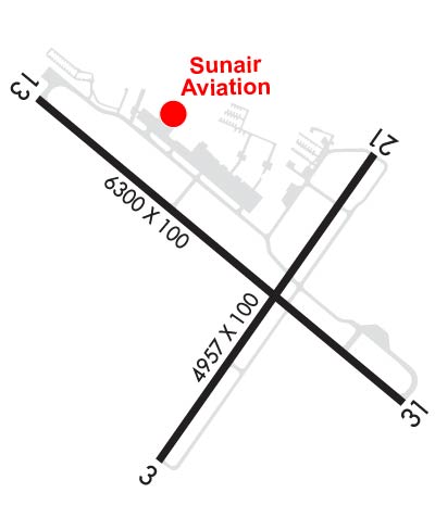
| Lat: N 2849.4 Long: W 08148.5 Elev: 76 Var: +05 Longest Runway: 6300 | ||
| Clr Del: 121.72 GCO Dept. ATIS: 134.32 Arr. ATIS: 134.32 AWOS: 134.32 Ground: 121.72 Tower: 119.35 | ||
| |||||||||||||||||||||||||||||||||||||||||||||||||||||||||||||||||||||
| |||||||||||||||||||||||||||||||||||||||||||||||||||||||||||||||||||||
| |||||||||||||||||||||||||||||||||||||||||||||||||||||||||||||||||||||
| Rwy | Rwy | |||||||
| 4957x100 | 4957' | 4957x100 | 4647' | |||||
| 15000x2000 | 15000' | 15000x2000 | 15000' | |||||
| 6300x100 | 6011' | 6300x100 | 5900' | |||||
| Runway ID | Single Wheel | Double Wheel | Double Tandem Wheel | Dual Double Wheel |
| 03/21 | 21,000 | N/A | N/A | N/A |
| 03W/21W | N/A | N/A | N/A | N/A |
| 13/31 | N/A | 60,000 | N/A | N/A |
| These numbers are Advisory and are not limits. The Airport Manager should have more accurate Weight Limits | ||||
 Airport Diagram might not be current. | |
| Facility Name: | LEESBURG INTL |
| City Name: | LEESBURG |
| County: | LAKE |
| State abbrev: | FL |
| State Name: | FLORIDA |
| Ownership: | PUBLICLY OWNED |
| Use: | OPEN TO THE PUBLIC |
| Owner's Name: | CITY OF LEESBURG |
| Address: | PO BOX 490630 |
| LEESBURG, FL 34749-0630 | |
| Owner's Phone: | 352-516-7236 |
| Manager's Name: | TRACEY DEAN |
| Address: | PO BOX 490630 |
| LEESBURG, FL 34749 | |
| Phone: | (352) 728-9801; EXT 1130 OR 352-728-9786. |
| FAA Region: | SOUTHERN |
| FAA Field Office: | ORL |
| Date | Sunrise | Sunset |
|---|---|---|
| 09/24/21 Friday | 7:17 | 19:22 |
| 09/25/21 Saturday | 7:17 | 19:20 |
| 09/26/21 Sunday | 7:18 | 19:19 |
| 09/27/21 Monday | 7:18 | 19:18 |
| 09/28/21 Tuesday | 7:19 | 19:17 |
| 09/29/21 Wednesday | 7:19 | 19:16 |
| 09/30/21 Thursday | 7:20 | 19:14 |
| 10/01/21 Friday | 7:20 | 19:13 |
| 10/02/21 Saturday | 7:21 | 19:12 |
| 10/03/21 Sunday | 7:21 | 19:11 |
| 10/04/21 Monday | 7:22 | 19:10 |
| 10/05/21 Tuesday | 7:22 | 19:09 |
| 10/06/21 Wednesday | 7:23 | 19:07 |
| 10/07/21 Thursday | 7:23 | 19:06 |
| Airport Attendance Schedule | 7 Days A Week 0700-1900 |
| Airport Status | OPERATIONAL (This Status can change at any time - please check NOTAMS) |
| Airport Lighting Schedule | WHEN ATCT CLSD ACTVT REILS RWY 13 & 31; PAPI RWY 3, 13, 21, & 31; MIRL RWY 03/21 & 13/31; TWY LGTS - CTAF. |
| Airport Storage Available | Tie Downs, Hanger |
| Extra Services Available | Crop Dusting, Avionics, Charter, Flight Instruction, Aircraft Rental, Aircraft Sales |
| Wind Indicator | YES - (lighted) |
| Control Tower | YES |
| CTAF Frequency | 119.350 |
| Unicom Frequency | 122.725 |
| Rotating Beacon Color | CLEAR-GREEN (Light Land Airport) |
| Segmented Circle | Y-L |
| Landing Fee | NO |
| Airport Inspected | STATE - performed by STATE AERONAUTICAL PERSONNEL |
| Inspection Date | 09/19/2018 |
| Type of Fuel Available | Grade 100LL, JET A (freeze point -40C); -1024 HR SELF SERVE. |
| Airframe Repair Service | MAJOR |
| Power Plant Repair Service | MAJOR |
| Latitude | N2849.4 |
| Longitude | W08148.5 (ESTIMATED) |
| Arpt Elevation | 75ft (SURVEYED) |
| Magnetic Variation | 05W |
| 3 miles NE | of LEESBURG |
| Traffic Pattern Altitude | |
| Sectional Chart | JACKSONVILLE |
| Operations (Reported) | Yearly | Avg. Daily |
|---|---|---|
| General Aviation Transient | 37876 | 104 |
| General Aviation Local | 37392 | 102 |
| Air Taxi | 0 | 0 |
| Commerical | 0 | 0 |
| Commuter | 0 | 0 |
| Military | 189 | 1 |
| Aircraft based on Field | |
|---|---|
| General Aviation Singles | 85 |
| General Aviation Multi | 12 |
| Jet Aircraft | 7 |
| General Aviation Helicopters | 27 |
| Military Aircraft | 0 |
| Gliders | 0 |
| Ultralights | 0 |
| FSS on field | NO |
| FSS tie-in | SAINT PETERSBURG |
| FSS Phone | 1-800-WX-BRIEF |
| Who issues Notams | LEE |
| Notam D service at airport | YES |
| ARTCC Name | JACKSONVILLE |
| Airport Certification | |
| Aircraft Rescue & Firefighting Index | None |
| Airport of Entry | No |
| Custom Landing Rights | No; US CUSTOMS USER FEE ARPT. |
| Joint Civil/Military | No |
| Military Landing rights | YES |
| NATIONAL PLAN OF INTEGRATED AIRPORT SYSTEMS (NPIAS) |
| GRANT AGREEMENTS UNDER FAAP/ADAP/AIP |
| SURPLUS PROPERTY AGREEMENT UNDER PUBLIC LAW 289 |
| ASSURANCES PURSUANT TO TITLE VI, CIVIL RIGHTS ACT OF 1964 |
| AGREEMENT UNDER DLAND OR DCLA HAS EXPIRED. |
| BIRD ACT INVOF ARPT. |
| FOR CD OR TO CNL IFR IF UNA VIA GCO CTC ORLANDO APCH AT 407-825-3398. |
| RWY 13/3 1 25 FT PAVED SHOULDERS EACH SIDE. TREES ALG SW SIDE OF RWY IN TRSN SFC. |
| RWY 03 TREES 235 FT W OF CNTRLN FOR FIRST 1000 FT INSIDE PRI SFC. |
Airport Communications & Frequencies:
| ||||||||||||||||||||||||||
| Runway: 03 | Runway: 21 | ||
| Mag heading: | 40° | Mag heading: | 220° |
| Rwy Slope: | .17% Up | Rwy Slope: | -.17% Down |
| Approach: | Approach: | ||
| Pattern: | Left Traffic | Pattern: | Left Traffic |
| Markings: | NONPRECISION INSTRUMENT | Markings: | BASIC |
| Marking Condition: | POOR; MARKINGS FADED. | Marking Condition: | POOR; MARKINGS FADED. |
| Arresting Dev: | Arresting Dev: | ||
| Lat & Long: | N2849.0 W08148.7 | Lat. & Long.: | N2849.6 W08148.2 |
| Elev: | 66.7 ft. MSL | Elev: | 75.1 ft. MSL |
| TCH: | 45 ft. AGL | TCH: | 45 ft. AGL |
| Visual Glide Path: | 3.00 degrees | Visual Glide Path: | 3.00 degrees |
| Displaced Threshold: | No | Displaced Threshold: | 310 feet |
| Touchdown Zone: | YES | Touchdown Zone: | YES |
| Touchdown Elev.: | 70.3 feet | Touchdown Elev.: | 73.6 feet |
| Visual Glide Slope: | 4-Light PAPI on LEFT side of Runway | Visual Glide Slope: | 4-Light PAPI on RIGHT side of Runway |
| RVR Equipment: | RVR Equipment: | ||
| RVV Equipment: | NO | RVV Equipment: | NO |
| Approach Lights: | Approach Lights: | ||
| REIL: | NO | REIL: | NO |
| Centerline Lights: | NO | Centerline Lights: | NO |
| Touchdown lights: | NO | Touchdown lights: | NO |
| Runway Category: | Runway with a Non-precision Approach | Runway Category: | Runway with a Visual Approach |
| Declared Distances: | TORA:4957' TODA:4957' ASDA:4688' LDA:4688' | Declared Distances: | TORA:4957' TODA:4957' ASDA:4647' LDA:4957' |
| Obstructions: | TREES | Obstructions: | BERM |
| Marked: | NOT Marked/Lighted | Marked: | MARKED and LIGHTED |
| Clearance slope: | Clearance slope: | 1:1; APCH SLOPE 21:1 TO DSPLCD THR. | |
| Obstruction height: | 38 feet AGL | Obstruction height: | 11 feet AGL |
| Dist. from runway: | 100 feet | Dist. from runway: | 81 feet |
| Centerline offset: | 235 left of centerline | Centerline offset: | |
| Comments: | 25 FT TREES 235 FT LEFT OF CNTRLN 100 FT FM RWY END. | Comments: | 11 FT BERM FULL WID OF RWY 81 FT FM RWY END. |
| Runway: 03W | Runway: 21W | ||
| Mag heading: | N/A | Mag heading: | N/A |
| Rwy Slope: | .00% | Rwy Slope: | .00% |
| Approach: | Approach: | ||
| Pattern: | Left Traffic | Pattern: | Left Traffic |
| Markings: | Markings: | ||
| Marking Condition: | Marking Condition: | ||
| Arresting Dev: | Arresting Dev: | ||
| Lat & Long: | Lat. & Long.: | ||
| Elev: | 63.0 ft. MSL | Elev: | 63.0 ft. MSL |
| TCH: | TCH: | ||
| Visual Glide Path: | Visual Glide Path: | ||
| Displaced Threshold: | No | Displaced Threshold: | No |
| Touchdown Zone: | NO | Touchdown Zone: | NO |
| Touchdown Elev.: | Touchdown Elev.: | ||
| Visual Glide Slope: | Visual Glide Slope: | ||
| RVR Equipment: | RVR Equipment: | ||
| RVV Equipment: | NO | RVV Equipment: | NO |
| Approach Lights: | Approach Lights: | ||
| REIL: | NO | REIL: | NO |
| Centerline Lights: | NO | Centerline Lights: | NO |
| Touchdown lights: | NO | Touchdown lights: | NO |
| Runway Category: | Runway Category: | ||
| Declared Distances: | Declared Distances: |
| Runway: 13 | Runway: 31 | ||
| Mag heading: | 135° | Mag heading: | 315° |
| Rwy Slope: | -.10% Down | Rwy Slope: | .10% Up |
| Approach: | Approach: | ||
| Pattern: | Left Traffic | Pattern: | Left Traffic |
| Markings: | NONPRECISION INSTRUMENT | Markings: | NONPRECISION INSTRUMENT |
| Marking Condition: | FAIR | Marking Condition: | FAIR |
| Arresting Dev: | Arresting Dev: | ||
| Lat & Long: | N2849.8 W08149.0 | Lat. & Long.: | N2849.1 W08148.1 |
| Elev: | 72.1 ft. MSL | Elev: | 66.0 ft. MSL |
| TCH: | 45 ft. AGL | TCH: | 45 ft. AGL |
| Visual Glide Path: | 3.00 degrees | Visual Glide Path: | 3.00 degrees |
| Displaced Threshold: | 289 feet | Displaced Threshold: | 400 feet |
| Touchdown Zone: | YES | Touchdown Zone: | YES |
| Touchdown Elev.: | 75.9 feet | Touchdown Elev.: | 73.4 feet |
| Visual Glide Slope: | 4-Light PAPI on LEFT side of Runway | Visual Glide Slope: | 4-Light PAPI on LEFT side of Runway |
| RVR Equipment: | RVR Equipment: | ||
| RVV Equipment: | NO | RVV Equipment: | NO |
| Approach Lights: | Approach Lights: | ||
| REIL: | YES | REIL: | YES |
| Centerline Lights: | NO | Centerline Lights: | NO |
| Touchdown lights: | NO | Touchdown lights: | NO |
| Runway Category: | Precision Instrument Runway | Runway Category: | Precision Instrument Runway |
| Declared Distances: | TORA:6300' TODA:6300' ASDA:5211' LDA:5500' | Declared Distances: | TORA:6300' TODA:6300' ASDA:5900' LDA:6300' |
| Obstructions: | TREES | Obstructions: | BRUSH |
| Marked: | NOT Marked/Lighted | Marked: | NOT Marked/Lighted |
| Clearance slope: | 26:1; APCH SLOPE 34:1 TO DSPLCD THR. | Clearance slope: | 3:1; APCH SLOPE 22:1 TO DSPLCD THR. |
| Obstruction height: | 68 feet AGL | Obstruction height: | 7 feet AGL |
| Dist. from runway: | 1982 feet | Dist. from runway: | 220 feet |
| Centerline offset: | 250 left of centerline | Centerline offset: | |
| Comments: | Comments: |
Thanks for using FltPlan.com
all rights reserved © 1999-2021 by Flight Plan LLC