
| MASON COUNTY LUDINGTON MI |
| |
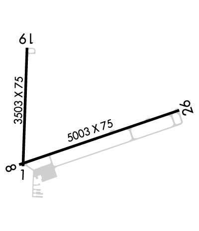
| Lat: N 4357.8 Long: W 08624.5 Elev: 646 Var: +03 Longest Runway: 5003 | ||
| AWOS: 119.92 CTAF: 123.0 | ||
| ||||||
| ||||||
|
| Rwy | Rwy | |||||||
| 3503x75 | 3503' | 3503x75 | 3503' | |||||
| 5003x75 | 5003' | 5003x75 | 5003' | |||||
| Runway ID | Single Wheel | Double Wheel | Double Tandem Wheel | Dual Double Wheel |
| 01/19 | 19,000 | N/A | N/A | N/A |
| 08/26 | 25,000 | N/A | N/A | N/A |
| These numbers are Advisory and are not limits. The Airport Manager should have more accurate Weight Limits | ||||
 Airport Diagram might not be current. | |
| Facility Name: | MASON COUNTY |
| City Name: | LUDINGTON |
| County: | MASON |
| State abbrev: | MI |
| State Name: | MICHIGAN |
| Ownership: | PUBLICLY OWNED |
| Use: | OPEN TO THE PUBLIC |
| Owner's Name: | COUNTY OF MASON |
| Address: | COURT HOUSE |
| LUDINGTON, MI 49431 | |
| Owner's Phone: | 231-843-8202 |
| Manager's Name: | JOHN L. O'CONNOR |
| Address: | 5300 WEST U.S. 10 |
| LUDINGTON, MI 49431 | |
| Phone: | 231-843-2049 |
| FAA Region: | GREAT LAKES |
| FAA Field Office: | DET |
| Date | Sunrise | Sunset |
|---|---|---|
| 09/24/21 Friday | 7:35 | 19:40 |
| 09/25/21 Saturday | 7:36 | 19:38 |
| 09/26/21 Sunday | 7:37 | 19:36 |
| 09/27/21 Monday | 7:38 | 19:34 |
| 09/28/21 Tuesday | 7:39 | 19:32 |
| 09/29/21 Wednesday | 7:41 | 19:31 |
| 09/30/21 Thursday | 7:42 | 19:29 |
| 10/01/21 Friday | 7:43 | 19:27 |
| 10/02/21 Saturday | 7:44 | 19:25 |
| 10/03/21 Sunday | 7:45 | 19:23 |
| 10/04/21 Monday | 7:47 | 19:21 |
| 10/05/21 Tuesday | 7:48 | 19:20 |
| 10/06/21 Wednesday | 7:49 | 19:18 |
| 10/07/21 Thursday | 7:50 | 19:16 |
| Airport Attendance Schedule | APR 16-OCT 15 7 Days A Week 0900-1700, OCT 16-APR 15 MON-FRI 0900-1700, OCT 16-APR 15 SAT-SUN UNATND |
| Airport Status | OPERATIONAL (This Status can change at any time - please check NOTAMS) |
| Airport Lighting Schedule | ACTVT MIRL RYS 08/26 & 01/19 PAPIS RYS 08, 26, 01 & 19, AND REIL RY 26 - CTAF. |
| Airport Storage Available | Tie Downs, Hanger |
| Extra Services Available | Charter |
| Wind Indicator | YES - (unlit) |
| Control Tower | NO |
| CTAF Frequency | 123.000 |
| Unicom Frequency | 123.000 |
| Rotating Beacon Color | CLEAR-GREEN (Light Land Airport) |
| Segmented Circle | YES |
| Landing Fee | NO |
| Airport Inspected | STATE - performed by STATE AERONAUTICAL PERSONNEL |
| Inspection Date | 10/11/2018 |
| Type of Fuel Available | Grade 100LL, JET A (freeze point -40C) |
| Airframe Repair Service | NONE |
| Power Plant Repair Service | NONE |
| Latitude | N4357.8 |
| Longitude | W08624.5 (ESTIMATED) |
| Arpt Elevation | 646ft (SURVEYED) |
| Magnetic Variation | 03W |
| 2 miles NE | of LUDINGTON |
| Traffic Pattern Altitude | |
| Sectional Chart | CHICAGO |
| Operations (Reported) | Yearly | Avg. Daily |
|---|---|---|
| General Aviation Transient | 4423 | 12 |
| General Aviation Local | 3259 | 9 |
| Air Taxi | 2000 | 5 |
| Commerical | 0 | 0 |
| Commuter | 0 | 0 |
| Military | 0 | 0 |
| Aircraft based on Field | |
|---|---|
| General Aviation Singles | 21 |
| General Aviation Multi | 3 |
| Jet Aircraft | 0 |
| General Aviation Helicopters | 0 |
| Military Aircraft | 0 |
| Gliders | 0 |
| Ultralights | 0 |
| FSS on field | NO |
| FSS tie-in | LANSING |
| FSS Phone | 1-800-WX-BRIEF |
| Who issues Notams | LDM |
| Notam D service at airport | YES |
| ARTCC Name | MINNEAPOLIS |
| Airport Certification | |
| Aircraft Rescue & Firefighting Index | None |
| Airport of Entry | No |
| Custom Landing Rights | No |
| Joint Civil/Military | No |
| Military Landing rights | YES |
| NATIONAL PLAN OF INTEGRATED AIRPORT SYSTEMS (NPIAS) |
| GRANT AGREEMENTS UNDER FAAP/ADAP/AIP |
| ASSURANCES PURSUANT TO TITLE VI, CIVIL RIGHTS ACT OF 1964 |
| THIS AIRPORT HAS BEEN SURVEYED BY THE NATIONAL GEODETIC SURVEY. |
| BIRDS & DEER ON & INVOF ARPT. |
| FOR CD IF UNA TO CTC ON FSS FREQ, CTC MINNEAPOLIS ARTCC AT 651-463-5588. |
Airport Communications & Frequencies:
| |||||||||
| Runway: 01 | Runway: 19 | ||
| Mag heading: | 5° | Mag heading: | 185° |
| Rwy Slope: | -.12% Down | Rwy Slope: | .12% Up |
| Approach: | Approach: | ||
| Pattern: | Left Traffic | Pattern: | Left Traffic |
| Markings: | BASIC | Markings: | BASIC |
| Marking Condition: | GOOD | Marking Condition: | GOOD |
| Arresting Dev: | Arresting Dev: | ||
| Lat & Long: | N4357.6 W08624.8 | Lat. & Long.: | N4358.1 W08624.8 |
| Elev: | 641.0 ft. MSL | Elev: | 636.9 ft. MSL |
| TCH: | 19 ft. AGL | TCH: | 21 ft. AGL |
| Visual Glide Path: | 3.00 degrees | Visual Glide Path: | 3.00 degrees |
| Displaced Threshold: | No | Displaced Threshold: | No |
| Touchdown Zone: | YES | Touchdown Zone: | YES |
| Touchdown Elev.: | 642.5 feet | Touchdown Elev.: | 641.2 feet |
| Visual Glide Slope: | 2-Light PAPI on LEFT side of Runway | Visual Glide Slope: | 2-Light PAPI on LEFT side of Runway |
| RVR Equipment: | RVR Equipment: | ||
| RVV Equipment: | NO | RVV Equipment: | NO |
| Approach Lights: | Approach Lights: | ||
| REIL: | NO | REIL: | NO |
| Centerline Lights: | NO | Centerline Lights: | NO |
| Touchdown lights: | NO | Touchdown lights: | NO |
| Runway Category: | Runway with a Visual Approach | Runway Category: | Runway with a Visual Approach |
| Declared Distances: | Declared Distances: | ||
| Obstructions: | Unknown | Obstructions: | TREES |
| Marked: | NOT Marked/Lighted | Marked: | NOT Marked/Lighted |
| Clearance slope: | 22:1 | Clearance slope: | 15:1 |
| Obstruction height: | 69 feet AGL | Obstruction height: | 75 feet AGL |
| Dist. from runway: | 1750 feet | Dist. from runway: | 1375 feet |
| Centerline offset: | 223 left of centerline | Centerline offset: | 215 feet left of centerline |
| Comments: | Comments: |
| Runway: 08 | Runway: 26 | ||
| Mag heading: | 74° | Mag heading: | 254° |
| Rwy Slope: | .10% Up | Rwy Slope: | -.10% Down |
| Approach: | Approach: | ||
| Pattern: | Left Traffic | Pattern: | Left Traffic |
| Markings: | NONPRECISION INSTRUMENT | Markings: | NONPRECISION INSTRUMENT |
| Marking Condition: | GOOD | Marking Condition: | GOOD |
| Arresting Dev: | Arresting Dev: | ||
| Lat & Long: | N4357.6 W08624.8 | Lat. & Long.: | N4357.8 W08623.7 |
| Elev: | 641.4 ft. MSL | Elev: | 646.4 ft. MSL |
| TCH: | 25 ft. AGL | TCH: | 25 ft. AGL |
| Visual Glide Path: | 3.00 degrees | Visual Glide Path: | 3.00 degrees |
| Displaced Threshold: | No | Displaced Threshold: | No |
| Touchdown Zone: | YES | Touchdown Zone: | YES |
| Touchdown Elev.: | 642.5 feet | Touchdown Elev.: | 646.4 feet |
| Visual Glide Slope: | 2-Light PAPI on LEFT side of Runway | Visual Glide Slope: | 4-Light PAPI on LEFT side of Runway |
| RVR Equipment: | RVR Equipment: | ||
| RVV Equipment: | NO | RVV Equipment: | NO |
| Approach Lights: | Approach Lights: | ||
| REIL: | NO | REIL: | YES |
| Centerline Lights: | NO | Centerline Lights: | NO |
| Touchdown lights: | NO | Touchdown lights: | NO |
| Runway Category: | Runway with a Non-precision Approach having visibility minimums greater than 3/4 mile | Runway Category: | Runway with a Non-precision Approach having visibility minimums greater than 3/4 mile |
| Declared Distances: | Declared Distances: | ||
| Obstructions: | TREES | Obstructions: | TREES |
| Marked: | NOT Marked/Lighted | Marked: | NOT Marked/Lighted |
| Clearance slope: | 17:1 | Clearance slope: | 21:1 |
| Obstruction height: | 83 feet AGL | Obstruction height: | 55 feet AGL |
| Dist. from runway: | 1678 feet | Dist. from runway: | 1400 feet |
| Centerline offset: | 100 left of centerline | Centerline offset: | 200 feet left of centerline |
| Comments: | Comments: |
Thanks for using FltPlan.com
all rights reserved © 1999-2021 by Flight Plan LLC
