
| LACONIA MUNI LACONIA NH |
| |
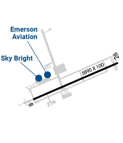
| Lat: N 4334.4 Long: W 07125.1 Elev: 545 Var: +16 Longest Runway: 5890 | ||
| Clr Del: 119.85 AWOS: 133.52 CTAF: 123.0 | ||
| |||||||||||||||||||||||||||||||||||||||||||||||||||||||||||||||||||||
| |||||||||||||||||||||||||||||||||||||||||||||||||||||||||||||||||||||
| |||||||||||||||||||||||||||||||||||||||||||||||||||||||||||||||||||||
| |||||||||||||||||||||||||||||||||||||||||||||||||||||||||||||||||||||
| Rwy | Rwy | |||||||
| 5890x100 | 5890' | 108.50 - 083° | 5890x100 | 5646' | ||||
| Runway ID | Single Wheel | Double Wheel | Double Tandem Wheel | Dual Double Wheel |
| 08/26 | 85,000 | 110,000 | 175,000 | N/A |
| These numbers are Advisory and are not limits. The Airport Manager should have more accurate Weight Limits | ||||
 Airport Diagram might not be current. | |
| Facility Name: | LACONIA MUNI |
| City Name: | LACONIA |
| County: | BELKNAP |
| State abbrev: | NH |
| State Name: | NEW HAMPSHIRE |
| Ownership: | PUBLICLY OWNED |
| Use: | OPEN TO THE PUBLIC |
| Owner's Name: | LACONIA AIRPORT AUTHORITY |
| Address: | 65 AVIATION DRIVE |
| GILFORD, NH 03429 | |
| Owner's Phone: | 603-524-5003 |
| Manager's Name: | MARV EVERSON |
| Address: | 65 AVIATION DRIVE |
| GILFORD, NH 03429 | |
| Phone: | 603-524-5003 |
| FAA Region: | NEW ENGLAND |
| FAA Field Office: | NONE |
| Date | Sunrise | Sunset |
|---|---|---|
| 09/24/21 Friday | 6:35 | 18:40 |
| 09/25/21 Saturday | 6:36 | 18:38 |
| 09/26/21 Sunday | 6:37 | 18:36 |
| 09/27/21 Monday | 6:38 | 18:34 |
| 09/28/21 Tuesday | 6:39 | 18:33 |
| 09/29/21 Wednesday | 6:41 | 18:31 |
| 09/30/21 Thursday | 6:42 | 18:29 |
| 10/01/21 Friday | 6:43 | 18:27 |
| 10/02/21 Saturday | 6:44 | 18:25 |
| 10/03/21 Sunday | 6:45 | 18:24 |
| 10/04/21 Monday | 6:46 | 18:22 |
| 10/05/21 Tuesday | 6:47 | 18:20 |
| 10/06/21 Wednesday | 6:49 | 18:18 |
| 10/07/21 Thursday | 6:50 | 18:16 |
| Airport Attendance Schedule | MAY-OCT 7 Days A Week 0700-1900, NOV-APR 7 Days A Week 0800-1800 |
| Airport Status | OPERATIONAL (This Status can change at any time - please check NOTAMS) |
| Airport Lighting Schedule | DUSK-DAWN. ACTVT MALSR RWY 08; REIL RWY 26; HIRL RWY 08/26; WINDSOCK LGTS - CTAF. |
| Airport Storage Available | Tie Downs, Hanger |
| Extra Services Available | Charter, Flight Instruction, Aircraft Rental, Aircraft Sales |
| Wind Indicator | YES - (lighted) |
| Control Tower | NO |
| CTAF Frequency | 123.000 |
| Unicom Frequency | 123.000 |
| Rotating Beacon Color | CLEAR-GREEN (Light Land Airport) |
| Segmented Circle | YES |
| Landing Fee | NO |
| Airport Inspected | STATE - performed by STATE AERONAUTICAL PERSONNEL |
| Inspection Date | 08/31/2020 |
| Type of Fuel Available | Grade 100LL, JET A (freeze point -40C); -A FOR JET A AFT HRS CALL FBOS.; -10100LL AVBL 24 HRS WITH CREDIT CARD SYS. |
| Airframe Repair Service | MAJOR |
| Power Plant Repair Service | MAJOR |
| Latitude | N4334.4 |
| Longitude | W07125.1 (ESTIMATED) |
| Arpt Elevation | 545ft (SURVEYED) |
| Magnetic Variation | 16W |
| 3 miles NE | of LACONIA |
| Traffic Pattern Altitude | |
| Sectional Chart | NEW YORK |
| Operations (Reported) | Yearly | Avg. Daily |
|---|---|---|
| General Aviation Transient | 3595 | 10 |
| General Aviation Local | 40000 | 110 |
| Air Taxi | 400 | 1 |
| Commerical | 0 | 0 |
| Commuter | 0 | 0 |
| Military | 105 | 0 |
| Aircraft based on Field | |
|---|---|
| General Aviation Singles | 100 |
| General Aviation Multi | 8 |
| Jet Aircraft | 3 |
| General Aviation Helicopters | 3 |
| Military Aircraft | 0 |
| Gliders | 0 |
| Ultralights | 1 |
| FSS on field | NO |
| FSS tie-in | BANGOR |
| FSS Phone | 1-800-WX-BRIEF |
| Who issues Notams | LCI |
| Notam D service at airport | YES |
| ARTCC Name | BOSTON |
| Airport Certification | |
| Aircraft Rescue & Firefighting Index | None |
| Airport of Entry | No |
| Custom Landing Rights | No |
| Joint Civil/Military | No |
| Military Landing rights | YES |
| NATIONAL PLAN OF INTEGRATED AIRPORT SYSTEMS (NPIAS) |
| GRANT AGREEMENTS UNDER FAAP/ADAP/AIP |
| ASSURANCES PURSUANT TO TITLE VI, CIVIL RIGHTS ACT OF 1964 |
| AGREEMENT UNDER DLAND OR DCLA HAS EXPIRED. |
| WILDLIFE ON & INVOF ARPT. |
| TWY ALPHA CLSD TO ACFT WITH WINGSPANS GTR THAN 49 FT. |
| FOR CD CTC BOSTON APCH AT 603-594-5552. |
| CTN: LOCKE'S HILL 500 FT TRRN MKD WITH 2 RED BCNS, 1.2 NM E OF ARPT. |
| CTN: RISING TRRN 5000 FT S OF ARPT. |
| RWY 26 DSGND CALM WIND RWY. |
| VOLUNTARY NOISE ABATEMENT PROC: AVOID OVERFLYING VARNEY POINT 1 NM NE OF ARPT. SEE LACONIA ARPT WEBSITE FOR DTLS. |
Airport Communications & Frequencies:
| ||||||||||||||||||
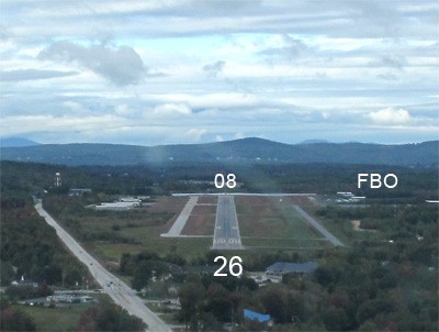
| Runway: 08 | Runway: 26 | ||
| Mag heading: | 84° | Mag heading: | 264° |
| Rwy Slope: | -.51% Down | Rwy Slope: | .51% Up |
| Approach: | ILS/DME | Approach: | |
| Pattern: | Left Traffic | Pattern: | Left Traffic |
| Markings: | PRECISION INSTRUMENT | Markings: | NONPRECISION INSTRUMENT |
| Marking Condition: | GOOD | Marking Condition: | GOOD |
| Arresting Dev: | Arresting Dev: | ||
| Lat & Long: | N4334.2 W07125.7 | Lat. & Long.: | N4334.6 W07124.5 |
| Elev: | 545.4 ft. MSL | Elev: | 515.5 ft. MSL |
| TCH: | 44 ft. AGL | TCH: | 55 ft. AGL |
| Visual Glide Path: | 3.00 degrees | Visual Glide Path: | 4.00 degrees |
| Displaced Threshold: | No | Displaced Threshold: | 244 feet |
| Touchdown Zone: | YES | Touchdown Zone: | YES |
| Touchdown Elev.: | 545.4 feet | Touchdown Elev.: | 533.2 feet |
| Visual Glide Slope: | 4-Light PAPI on LEFT side of Runway | Visual Glide Slope: | 4-Light PAPI on RIGHT side of Runway; PAPI UNUSBL BYD 6 DEGS LEFT OF CNTRLN. |
| RVR Equipment: | RVR Equipment: | ||
| RVV Equipment: | NO | RVV Equipment: | NO |
| Approach Lights: | MALSR - 1,400 foot medium intensity approach lighting system with runway alignment indicator lights | Approach Lights: | |
| REIL: | NO | REIL: | YES |
| Centerline Lights: | NO | Centerline Lights: | NO |
| Touchdown lights: | NO | Touchdown lights: | NO |
| Runway Category: | Precision Instrument Runway | Runway Category: | Runway with a Non-precision Approach having visibility minimums greater than 3/4 mile |
| Declared Distances: | TORA:5890' TODA:5890' ASDA:5646' LDA:5646' | Declared Distances: | TORA:5890' TODA:5890' ASDA:5530' LDA:5286' |
| Obstructions: | TREES | Obstructions: | TREES |
| Marked: | NOT Marked/Lighted | Marked: | NOT Marked/Lighted |
| Clearance slope: | 21:1 | Clearance slope: | 9:1 |
| Obstruction height: | 116 feet AGL | Obstruction height: | 58 feet AGL |
| Dist. from runway: | 2722 feet | Dist. from runway: | 765 feet |
| Centerline offset: | 456 right of centerline | Centerline offset: | 442 feet right of centerline |
| Comments: | Comments: |
Thanks for using FltPlan.com
all rights reserved © 1999-2021 by Flight Plan LLC