| LUMBERTON MUNI LUMBERTON NC |
| |
| Lat: N 3436.6 Long: W 07903.6 Elev: 125 Var: +08 Longest Runway: 5505 | ||
| AWOS: 134.77 CTAF: 122.8 | ||
| ||||||||||||||||||||||||||||||||||||||||||||||||||||||||||||||||||||
| ||||||||||||||||||||||||||||||||||||||||||||||||||||||||||||||||||||
| ||||||||||||||||||||||||||||||||||||||||||||||||||||||||||||||||||||
| Rwy | Rwy | |||||||
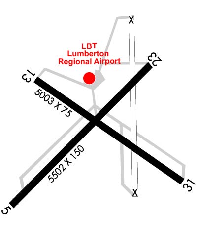
| 5505x150 | 5343' | 108.95 - 053° | 5505x150 | 5505' | ||||
| 5007x75 | 5007' | 5007x75 | 4417' | |||||
| Runway ID | Single Wheel | Double Wheel | Double Tandem Wheel | Dual Double Wheel |
| 05/23 | 15,000 | 80,000 | N/A | N/A |
| 13/31 | 8,000 | N/A | N/A | N/A |
| These numbers are Advisory and are not limits. The Airport Manager should have more accurate Weight Limits | ||||
 Airport Diagram might not be current. | |
| Facility Name: | LUMBERTON RGNL |
| City Name: | LUMBERTON |
| County: | ROBESON |
| State abbrev: | NC |
| State Name: | NORTH CAROLINA |
| Ownership: | PUBLICLY OWNED |
| Use: | OPEN TO THE PUBLIC |
| Owner's Name: | CITY OF LUMBERTON |
| Address: | P. O. BOX 1388 |
| LUMBERTON, NC 28359 | |
| Owner's Phone: | 910-671-3800 |
| Manager's Name: | GARY LEWIS |
| Address: | 163 AIRPORT BLVD |
| LUMBERTON, NC 28358 | |
| Phone: | 910-739-6480 |
| FAA Region: | SOUTHERN |
| FAA Field Office: | MEM |
| Date | Sunrise | Sunset |
|---|---|---|
| 06/08/26 Monday | 6:03 | 20:28 |
| 06/09/26 Tuesday | 6:03 | 20:28 |
| 06/10/26 Wednesday | 6:03 | 20:29 |
| 06/11/26 Thursday | 6:03 | 20:29 |
| 06/12/26 Friday | 6:03 | 20:29 |
| 06/13/26 Saturday | 6:03 | 20:30 |
| 06/14/26 Sunday | 6:03 | 20:30 |
| 06/15/26 Monday | 6:03 | 20:31 |
| 06/16/26 Tuesday | 6:03 | 20:31 |
| 06/17/26 Wednesday | 6:03 | 20:31 |
| 06/18/26 Thursday | 6:03 | 20:32 |
| 06/19/26 Friday | 6:03 | 20:32 |
| 06/20/26 Saturday | 6:03 | 20:32 |
| 06/21/26 Sunday | 6:04 | 20:32 |
| Airport Attendance Schedule | SAT-SUN 1000-1700, MON-FRI 0800-1700; UNATNDD CHRISTMAS & THANKSGIVING. |
| Airport Status | OPERATIONAL (This Status can change at any time - please check NOTAMS) |
| Airport Lighting Schedule | ACTVT REIL RWY 05 & 23; PAPI RWY 05 & 23; MIRL RWY 05/23 - CTAF. |
| Airport Storage Available | Tie Downs, Hanger |
| Extra Services Available | Charter, Flight Instruction, Aircraft Rental, Aircraft Sales |
| Wind Indicator | YES - (lighted) |
| Control Tower | NO |
| CTAF Frequency | 122.800 |
| Unicom Frequency | 122.800 |
| Rotating Beacon Color | WG |
| Segmented Circle | YES |
| Landing Fee | NO |
| Airport Inspected | STATE - performed by STATE AERONAUTICAL PERSONNEL |
| Inspection Date | 11/02/2022 |
| Type of Fuel Available | Grade 100LL, JET A-1 (icing inhibitor, freeze point -50C)MOGAS; -A1PPR FOR JET A FUEL AFTER HRS, CALL AMGR 910-608-1219.; -10100LL FUEL 24 HR CREDIT CARD SVC AVBL. |
| Airframe Repair Service | MAJOR |
| Power Plant Repair Service | MAJOR |
| Latitude | N3436.6 |
| Longitude | W07903.6 (ESTIMATED) |
| Arpt Elevation | 124ft (SURVEYED) |
| Magnetic Variation | 08W |
| 3 miles W | of LUMBERTON |
| Traffic Pattern Altitude | |
| Sectional Chart | CHARLOTTE |
| Operations (Reported) | Yearly | Avg. Daily |
|---|---|---|
| General Aviation Transient | 0 | 0 |
| General Aviation Local | 0 | 0 |
| Air Taxi | 0 | 0 |
| Commerical | 0 | 0 |
| Commuter | 0 | 0 |
| Military | 0 | 0 |
| Aircraft based on Field | |
|---|---|
| General Aviation Singles | 0 |
| General Aviation Multi | 0 |
| Jet Aircraft | 0 |
| General Aviation Helicopters | 0 |
| Military Aircraft | 0 |
| Gliders | 0 |
| Ultralights | 0 |
| FSS on field | NO |
| FSS tie-in | RALEIGH |
| FSS Phone | 1-800-WX-BRIEF |
| Who issues Notams | LBT |
| Notam D service at airport | YES |
| ARTCC Name | WASHINGTON |
| Airport Certification | |
| Aircraft Rescue & Firefighting Index | None |
| Airport of Entry | No |
| Custom Landing Rights | No |
| Joint Civil/Military | No |
| Military Landing rights | YES |
| NATIONAL PLAN OF INTEGRATED AIRPORT SYSTEMS (NPIAS) |
| GRANT AGREEMENTS UNDER FAAP/ADAP/AIP |
| ASSURANCES PURSUANT TO TITLE VI, CIVIL RIGHTS ACT OF 1964 |
| AGREEMENT UNDER DLAND OR DCLA HAS EXPIRED. |
| RWYS 05/23 & 13/31 NO LN OF SIGHT BTN RWY ENDS. |
| DEER & BIRDS ON & INVOF ARPT. |
| FARMING OPS NEAR RWYS AND TWYS. |
| FOR CD CTC WASHINGTON ARTCC AT 703-771-3587. |
Airport Communications & Frequencies:
| ||||||||||||||
| Runway: 05 | Runway: 23 | ||
| Mag heading: | 53° | Mag heading: | 233° |
| Rwy Slope: | .00% Down | Rwy Slope: | .00% Up |
| Approach: | ILS | Approach: | |
| Pattern: | Left Traffic | Pattern: | Left Traffic |
| Markings: | PRECISION INSTRUMENT | Markings: | PRECISION INSTRUMENT |
| Marking Condition: | GOOD | Marking Condition: | GOOD |
| Arresting Dev: | Arresting Dev: | ||
| Lat & Long: | N3436.3 W07904.0 | Lat. & Long.: | N3436.9 W07903.3 |
| Elev: | 123.2 ft. MSL | Elev: | 123.1 ft. MSL |
| TCH: | 60 ft. AGL | TCH: | 45 ft. AGL |
| Visual Glide Path: | 3.00 degrees | Visual Glide Path: | 3.20 degrees |
| Displaced Threshold: | 162 feet | Displaced Threshold: | No |
| Touchdown Zone: | YES | Touchdown Zone: | YES |
| Touchdown Elev.: | 124.4 feet | Touchdown Elev.: | 124.6 feet |
| Visual Glide Slope: | 4-Light PAPI on LEFT side of Runway | Visual Glide Slope: | 2-Light PAPI on LEFT side of Runway |
| RVR Equipment: | RVR Equipment: | ||
| RVV Equipment: | NO | RVV Equipment: | NO |
| Approach Lights: | Approach Lights: | ||
| REIL: | YES | REIL: | YES |
| Centerline Lights: | NO | Centerline Lights: | NO |
| Touchdown lights: | NO | Touchdown lights: | NO |
| Runway Category: | Precision Instrument Runway | Runway Category: | Runway with a Non-precision Approach having visibility minimums greater than 3/4 mile |
| Declared Distances: | Declared Distances: | ||
| Obstructions: | TREES | Obstructions: | TREES |
| Marked: | NOT Marked/Lighted | Marked: | NOT Marked/Lighted |
| Clearance slope: | 24:1; APCH RATIO 26:1 AT DSPLCD THR. | Clearance slope: | 9:1 |
| Obstruction height: | 78 feet AGL | Obstruction height: | 44 feet AGL |
| Dist. from runway: | 2140 feet | Dist. from runway: | 630 feet |
| Centerline offset: | 506 right of centerline | Centerline offset: | 178 feet left of centerline |
| Comments: | Comments: | 56 FT TREES 0-200 FT FM THR OFFSET 233 FT LEFT. |
| Runway: 13 | Runway: 31 | ||
| Mag heading: | 133° | Mag heading: | 313° |
| Rwy Slope: | -.05% Down | Rwy Slope: | .05% Up |
| Approach: | Approach: | ||
| Pattern: | Left Traffic | Pattern: | Left Traffic |
| Markings: | NONPRECISION INSTRUMENT | Markings: | NONPRECISION INSTRUMENT |
| Marking Condition: | GOOD | Marking Condition: | GOOD |
| Arresting Dev: | Arresting Dev: | ||
| Lat & Long: | N3436.8 W07903.9 | Lat. & Long.: | N3436.4 W07903.1 |
| Elev: | 123.8 ft. MSL | Elev: | 121.3 ft. MSL |
| TCH: | TCH: | ||
| Visual Glide Path: | Visual Glide Path: | ||
| Displaced Threshold: | No | Displaced Threshold: | 590 feet |
| Touchdown Zone: | YES | Touchdown Zone: | YES |
| Touchdown Elev.: | 124.6 feet | Touchdown Elev.: | 124.6 feet |
| Visual Glide Slope: | Visual Glide Slope: | ||
| RVR Equipment: | RVR Equipment: | ||
| RVV Equipment: | NO | RVV Equipment: | NO |
| Approach Lights: | Approach Lights: | ||
| REIL: | NO | REIL: | NO |
| Centerline Lights: | NO | Centerline Lights: | NO |
| Touchdown lights: | NO | Touchdown lights: | NO |
| Runway Category: | Runway with a Non-precision Approach | Runway Category: | Runway with a Visual Approach |
| Declared Distances: | Declared Distances: | ||
| Obstructions: | TREES | Obstructions: | TREES |
| Marked: | NOT Marked/Lighted | Marked: | NOT Marked/Lighted |
| Clearance slope: | 7:1 | Clearance slope: | 3:1; APCH RATIO 21:1 AT DSPLCD THR. |
| Obstruction height: | 38 feet AGL | Obstruction height: | 29 feet AGL |
| Dist. from runway: | 468 feet | Dist. from runway: | 297 feet |
| Centerline offset: | 155 left of centerline | Centerline offset: | 7 feet right of centerline |
| Comments: | 9 FT FENCE 100 FT TO 200 FT FM THR OFFSET 240 FT L AND R OF CNTRLN. | Comments: | 15 FT ROAD 170 FT FM THR BOTH SIDES AND 10 FT FENCE 154 FT FM THR BOTH SIDES. |
Thanks for using FltPlan.com
all rights reserved © 1999-2026 by Flight Plan LLC