
| HARRY REID INTL LAS VEGAS NV |
| |
| Lat: N 3604.8 Long: W 11509.1 Elev: 2183 Var: -11 Longest Runway: 14835 | ||
| Clr Del: 118.0 Dept. ATIS: 132.4 Arr. ATIS: 132.4 Ground: 121.1/121.9 Tower: 119.9/118.75 | ||

| |||||||||||||||||||||||||||||||||||||||||||||||||||||||||||||||||||||
| |||||||||||||||||||||||||||||||||||||||||||||||||||||||||||||||||||||
| |||||||||||||||||||||||||||||||||||||||||||||||||||||||||||||||||||||
| |||||||||||||||||||||||||||||||||||||||||||||||||||||||||||||||||||||
| |||||||||||||||||||||||||||||||||||||||||||||||||||||||||||||||||||||
| |||||||||||||||||||||||||||||||||||||||||||||||||||||||||||||||||||||
| FBOs at nearby airports who want your business: | |||||||||||||||||
| |||||||||||||||||
| Rwy | Rwy | |||||||
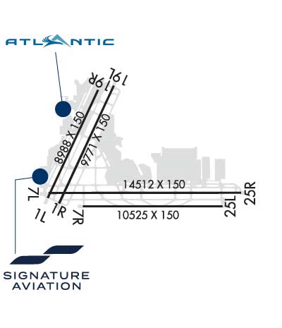
| 9770x150 | 9184' | 110.10 - 013° | 9770x150 | 8987' | ||||
| 9769x150 | 9279' | 9769x150 | 8892' | |||||
| 14835x150 | 12376' | 14835x150 | 13436' | 110.30 - 258° | ||||
| 10526x150 | 10526' | 10526x150 | 10526' | 111.50 - 258° | ||||
| Runway ID | Single Wheel | Double Wheel | Double Tandem Wheel | Dual Double Wheel |
| 01L/19R | 120,000 | 250,000 | 550,000 | 1,120,000 |
| 01R/19L | 120,000 | 250,000 | 550,000 | 1,120,000 |
| 08L/26R | 120,000 | 250,000 | 550,000 | 1,120,000 |
| 08R/26L | 120,000 | 250,000 | 550,000 | 1,120,000 |
| These numbers are Advisory and are not limits. The Airport Manager should have more accurate Weight Limits | ||||
 Airport Diagram might not be current. | |
| Facility Name: | HARRY REID INTL |
| City Name: | LAS VEGAS |
| County: | CLARK |
| State abbrev: | NV |
| State Name: | NEVADA |
| Ownership: | PUBLICLY OWNED |
| Use: | OPEN TO THE PUBLIC |
| Owner's Name: | CLARK COUNTY |
| Address: | P O BOX 11005 |
| LAS VEGAS, NV 89111 | |
| Owner's Phone: | 702-261-5211 |
| Manager's Name: | BRIAN FREEBURG; JAMES CHRISLY 702-261-5125. 24 HR OPS - 702-261-5605/5211. |
| Address: | 5757 WAYNE NEWTON BLVD |
| LAS VEGAS, NV 89119 | |
| Phone: | 702-261-5333 |
| FAA Region: | WESTERN-PACIFIC |
| FAA Field Office: | PHX |

| Date | Sunrise | Sunset |
|---|---|---|
| 07/10/26 Friday | 5:32 | 20:00 |
| 07/11/26 Saturday | 5:32 | 19:59 |
| 07/12/26 Sunday | 5:33 | 19:59 |
| 07/13/26 Monday | 5:34 | 19:59 |
| 07/14/26 Tuesday | 5:34 | 19:58 |
| 07/15/26 Wednesday | 5:35 | 19:58 |
| 07/16/26 Thursday | 5:36 | 19:57 |
| 07/17/26 Friday | 5:36 | 19:57 |
| 07/18/26 Saturday | 5:37 | 19:56 |
| 07/19/26 Sunday | 5:38 | 19:56 |
| 07/20/26 Monday | 5:39 | 19:55 |
| 07/21/26 Tuesday | 5:39 | 19:54 |
| 07/22/26 Wednesday | 5:40 | 19:54 |
| 07/23/26 Thursday | 5:41 | 19:53 |
| Airport Attendance Schedule | CONTINUOUS |
| Airport Status | OPERATIONAL (This Status can change at any time - please check NOTAMS) |
| Airport Lighting Schedule | SS-SR |
| Airport Storage Available | Tie Downs, Hanger |
| Extra Services Available | Air Freight, Air Ambulance, Avionics, Cargo Handling, Charter, Flight Instruction, Aircraft Rental, Aircraft Sales, Annual Surveying |
| Wind Indicator | YES - (lighted) |
| Control Tower | YES |
| CTAF Frequency | |
| Unicom Frequency | 122.950 |
| Rotating Beacon Color | WG |
| Segmented Circle | NO |
| Landing Fee | NO |
| Airport Inspected | FEDERAL - performed by FAA AIRPORTS FIELD PERSONNEL |
| Inspection Date | 03/25/2024 |
| Type of Fuel Available | Grade 100, Grade 100LL, JET A-1 (icing inhibitor, freeze point -50C) |
| Airframe Repair Service | MAJOR |
| Power Plant Repair Service | MAJOR |
| Latitude | N3604.8 |
| Longitude | W11509.1 (ESTIMATED) |
| Arpt Elevation | 2183ft (SURVEYED) |
| Magnetic Variation | 11E |
| 5 miles S | of LAS VEGAS |
| Traffic Pattern Altitude | |
| Sectional Chart | LAS VEGAS |
| Operations (Reported) | Yearly | Avg. Daily |
|---|---|---|
| General Aviation Transient | 0 | 0 |
| General Aviation Local | 0 | 0 |
| Air Taxi | 0 | 0 |
| Commerical | 0 | 0 |
| Commuter | 0 | 0 |
| Military | 0 | 0 |
| Aircraft based on Field | |
|---|---|
| General Aviation Singles | 0 |
| General Aviation Multi | 0 |
| Jet Aircraft | 0 |
| General Aviation Helicopters | 0 |
| Military Aircraft | 0 |
| Gliders | 0 |
| Ultralights | 0 |
| FSS on field | NO |
| FSS tie-in | RENO |
| FSS Phone | 1-800-WX-BRIEF |
| Who issues Notams | LAS |
| Notam D service at airport | YES |
| ARTCC Name | LOS ANGELES |
| Airport Certification | AIRPORT RECEIVING SCHEDULED AIR CARRIER SERVICE FROM CARRIERS CERTIFICATED BY THE CIVIL AERONAUTICS BOARD |
| Aircraft Rescue & Firefighting Index | AIRPORT HAS A CERTIFICATE UNDER CFR PART 139 |
| Airport of Entry | No |
| Custom Landing Rights | YES |
| Joint Civil/Military | No |
| Military Landing rights | YES |
| NATIONAL PLAN OF INTEGRATED AIRPORT SYSTEMS (NPIAS) |
| GRANT AGREEMENTS UNDER FAAP/ADAP/AIP |
| SURPLUS PROPERTY AGREEMENT UNDER PUBLIC LAW 289 |
| CONVEYANCE UNDER SCETION 16, FEDERAL AIRPORT ACT OF 1946 OR SECTION 23, AIRPORT AND AIRWAY DEVELOPMENT ACT OF 1970 |
| ASSURANCES PURSUANT TO TITLE VI, CIVIL RIGHTS ACT OF 1964 |
| EXTSV GLDR/SOARING OPNS WKENDS & HOLS; SR-SS; LAS R187/020; ALTS UP TO BUT NOT INCLG FL180. GLDRS RMN CLEAR OF THE TCA BUT OTHERWISE OPR WI THE ENTIRE SW QUAD OF THE TCA VEIL. |
| LGTD GOLF RANGE 1400 FT S OF RWYS 01L/19R AND 01R/19L. |
| TIEDOWN FEE. |
| (E98) PLUS 64 SHELTERS & 24 SHEDS. |
| ALL NON-STD RWY OPNS PPR FM DEPT OF AVN. |
| LRG NR OF BIRDS AND BATS INVOF OF ARPT BTWN SS AND SR. |
| TBJT DEPS NOT PMTD ON RWY 01R/19L OR RWY 01L/19R 2000-0800. XCPNS FOR WX OR OPNL NECESSITY. |
| ACFT OPER NEAR THE INT OF TWYS S, D, G AND THE N END OF TWY Z SHOULD BE ALERT AS THERE ARE CLOSELY ALIGNED TWY CNTRLN AND RADIUS TURNS. |
| ACFT THAT DEP FULL LENGTH OF RWYS 01L AND 08L MUST HOLD AT THE SAME HOLD LINE AS THERE IS NO ROOM TO HOLD BTN THE RWY ENDS AND SUCH ACFT SHOULD VERIFY THAT THEY ARE ON THE CORRECT RWY. |
| CUST PPR - 702-739-1100/702-736-1830/702-730-6071. GA CUST RSVNS 12 HR PPR. GA CUST & IMG LCT W SIDE BTN FBOS. |
| WINGSPAN GTR THAN 135 FT PPR FM DEPT OF AVN TO USE TWY H. |
| NMRS HOP ON WEST SIDE OF ARPT. |
| ACFT TAX WB ON TWY B NEAR TWY E USE CARE NOT TO ENTER THE RWY ON TWY Y, ACFT TAX WB ON TWY W NEAR TWY E USE CARE NOT TO ENTER THE RWY ON TWY U. |
| ACFT MAY EXPERIENCE REFLECTION OF SUN FM GLASS HOTELS LCTD NW OF ARPT. REFLECTION MAY OCCUR AT VARIOUS ALTS, HDGS, & DSTCS FM ARPT. |
| RWY STS LGTS ARE IN OPN. |
| PLA AUZD BTN 0200 & 0600. |
| CTN PAJA INVOF ARPT. |
| WHEN SPL EVENT PRKG PPR PROGRAM NOTAM IS ACTV, TSNT ACFT OPERS NOT PERM BASED NEED TO OBTAIN A PPR NR FM AN FBO FOR EA LDG. PPR APPVL & CONFIRMATION NRS CAN BE OBTAINED FM THE SEL FBO AT 702-261-7775. PPR CONFIRMATION NRS SHOULD BE ENTERED IN THE |
| ALL ACFT CTC RAMP CTL ON FREQ 124.4 FOR OPS AT A, B, C GATES, AND GA, CUSTOMS; CTC RAMP CTL FREQ 127.9 FOR OPNS AT D AND E GATES AND CARGO RAMP PRIOR TO ENTERING RAMP OR PUSHING BACK FM GATE OR PRKG SPOT. RAMP CTL OPR HRS 0500-0100L. WHEN RAMP IS CLSD (0100-0500L) BROADCAST ALL NON-MOVEMENT AREA OPNS ON UNICOM 122.95. |
| PILOTS CONDUCTING EFVS OPS; BE AWARE LED ALS IN USE RWY 26L. |
| GA CBP RSVN REQ - WEBSITE. |
| DLY WX BLN LAUNCH APRX 1100Z & 2300Z, 0400L & 1600L DRG DST, 0300L & 1500L ALL OTHER TIMES, 3.1 NM SW, APRX 221 DEGS, FM TWR. |
| GA PRKG VERY LTD. FOR PRKG AVAILABILITY CTC EITHER FBO (702) 736-1830 OR (702) 739-1100. |
| RWY 08L 589 FT CWY; RWY 26R 645 FT CWY. |
| RWY 01L/ 19RPCR VALUE: 1090/R/B/W/T |
| RWY 01R/ 19LPCR VALUE: 1230/R/B/W/T |
| RWY 08L/ 26RPCR VALUE: 1130/R/C/W/T |
| RWY 08R/ 26LPCR VALUE: 1150/R/B/W/T |
Airport Communications & Frequencies:
| |||||||||||||||||||||||||||||||||||||||||||||||||||||||||
| Runway: 01L | Runway: 19R | ||
| Mag heading: | 14° | Mag heading: | 194° |
| Rwy Slope: | -1.01% Down | Rwy Slope: | 1.01% Up |
| Approach: | ILS/DME | Approach: | |
| Pattern: | Left Traffic | Pattern: | Right Traffic |
| Markings: | PRECISION INSTRUMENT | Markings: | NONPRECISION INSTRUMENT |
| Marking Condition: | GOOD | Marking Condition: | GOOD |
| Arresting Dev: | Arresting Dev: | ||
| Lat & Long: | N3604.5 W11510.2 | Lat. & Long.: | N3606.0 W11509.4 |
| Elev: | 2181.2 ft. MSL | Elev: | 2082.3 ft. MSL |
| TCH: | 63 ft. AGL | TCH: | 80 ft. AGL |
| Visual Glide Path: | 3.40 degrees | Visual Glide Path: | 3.04 degrees |
| Displaced Threshold: | 586 feet | Displaced Threshold: | 783 feet |
| Touchdown Zone: | YES | Touchdown Zone: | YES |
| Touchdown Elev.: | 2176.1 feet | Touchdown Elev.: | 2116.4 feet |
| Visual Glide Slope: | 4-Light PAPI on LEFT side of Runway | Visual Glide Slope: | 4-Light PAPI on LEFT side of Runway |
| RVR Equipment: | RVR Equipment: | ||
| RVV Equipment: | NO | RVV Equipment: | NO |
| Approach Lights: | MALSF - 1,400 foot medium intensity approach lighting system with sequenced flashers | Approach Lights: | |
| REIL: | NO | REIL: | YES |
| Centerline Lights: | NO | Centerline Lights: | NO |
| Touchdown lights: | NO | Touchdown lights: | NO |
| Runway Category: | Precision Instrument Runway | Runway Category: | Runway with a Non-precision Approach having visibility minimums greater than 3/4 mile |
| Declared Distances: | TORA:8988' TODA:8988' ASDA:8988' LDA:8402' | Declared Distances: | TORA:9770' TODA:10182' ASDA:9199' LDA:8416' |
| Obstructions: | RR | Obstructions: | FENCE |
| Marked: | NOT Marked/Lighted | Marked: | NOT Marked/Lighted |
| Clearance slope: | 21:1; APCH RATIO 34:1 TO DTHR. | Clearance slope: | APCH RATIO 20:1 TO DTHR. |
| Obstruction height: | 48 feet AGL | Obstruction height: | 25 feet AGL |
| Dist. from runway: | 1225 feet | Dist. from runway: | 190 feet |
| Centerline offset: | 500 left of centerline | Centerline offset: | 150 feet right of centerline |
| Comments: | Comments: |
| Runway: 01R | Runway: 19L | ||
| Mag heading: | 14° | Mag heading: | 194° |
| Rwy Slope: | -1.00% Down | Rwy Slope: | 1.00% Up |
| Approach: | Approach: | ||
| Pattern: | Right Traffic | Pattern: | Left Traffic |
| Markings: | NONPRECISION INSTRUMENT | Markings: | NONPRECISION INSTRUMENT |
| Marking Condition: | GOOD | Marking Condition: | GOOD |
| Arresting Dev: | Arresting Dev: | ||
| Lat & Long: | N3604.5 W11510.0 | Lat. & Long.: | N3605.9 W11509.2 |
| Elev: | 2175.1 ft. MSL | Elev: | 2077.6 ft. MSL |
| TCH: | 76 ft. AGL | TCH: | 75 ft. AGL |
| Visual Glide Path: | 3.00 degrees | Visual Glide Path: | 3.00 degrees |
| Displaced Threshold: | 490 feet | Displaced Threshold: | 877 feet |
| Touchdown Zone: | YES | Touchdown Zone: | YES |
| Touchdown Elev.: | 2169.8 feet | Touchdown Elev.: | 2111.9 feet |
| Visual Glide Slope: | 4-Light PAPI on LEFT side of Runway | Visual Glide Slope: | 4-Light PAPI on LEFT side of Runway |
| RVR Equipment: | RVR Equipment: | ||
| RVV Equipment: | NO | RVV Equipment: | NO |
| Approach Lights: | Approach Lights: | ||
| REIL: | YES | REIL: | YES |
| Centerline Lights: | NO | Centerline Lights: | NO |
| Touchdown lights: | NO | Touchdown lights: | NO |
| Runway Category: | Runway with a Non-precision Approach having visibility minimums greater than 3/4 mile | Runway Category: | Runway with a Non-precision Approach having visibility minimums greater than 3/4 mile |
| Declared Distances: | TORA:9769' TODA:10166' ASDA:9274' LDA:8784' | Declared Distances: | TORA:9769' TODA:10169' ASDA:9684' LDA:8807' |
| Obstructions: | RR | Obstructions: | POLE |
| Marked: | NOT Marked/Lighted | Marked: | NOT Marked/Lighted |
| Clearance slope: | 15:1; APCH RATIO 23:1 TO DTHR. | Clearance slope: | 42:1; APCH RATIO 50:1 TO DTHR. |
| Obstruction height: | 41 feet AGL | Obstruction height: | 17 feet AGL |
| Dist. from runway: | 825 feet | Dist. from runway: | 929 feet |
| Centerline offset: | 600 right of centerline | Centerline offset: | 17 feet right of centerline |
| Comments: | Comments: |
| Runway: 08L | Runway: 26R | ||
| Mag heading: | 79° | Mag heading: | 259° |
| Rwy Slope: | -1.01% Down | Rwy Slope: | 1.01% Up |
| Approach: | Approach: | ILS/DME | |
| Pattern: | Left Traffic | Pattern: | Left Traffic |
| Markings: | NONPRECISION INSTRUMENT | Markings: | PRECISION INSTRUMENT |
| Marking Condition: | GOOD | Marking Condition: | GOOD |
| Arresting Dev: | Arresting Dev: | ||
| Lat & Long: | N3604.6 W11510.3 | Lat. & Long.: | N3604.6 W11507.3 |
| Elev: | 2183.1 ft. MSL | Elev: | 2033.0 ft. MSL |
| TCH: | 76 ft. AGL | TCH: | 84 ft. AGL |
| Visual Glide Path: | 3.00 degrees | Visual Glide Path: | 3.00 degrees |
| Displaced Threshold: | 2459 feet | Displaced Threshold: | 1399 feet |
| Touchdown Zone: | YES | Touchdown Zone: | YES |
| Touchdown Elev.: | 2154.9 feet | Touchdown Elev.: | 2066.9 feet |
| Visual Glide Slope: | 4-Light PAPI on LEFT side of Runway | Visual Glide Slope: | 4-Light PAPI on LEFT side of Runway |
| RVR Equipment: | RVR Equipment: | ||
| RVV Equipment: | NO | RVV Equipment: | NO |
| Approach Lights: | Approach Lights: | MALS - 1,400 foot medium intensity approach lighting system | |
| REIL: | NO | REIL: | NO |
| Centerline Lights: | NO | Centerline Lights: | NO |
| Touchdown lights: | NO | Touchdown lights: | NO |
| Runway Category: | Runway with a Visual Approach | Runway Category: | Precision Instrument Runway |
| Declared Distances: | TORA:14835' TODA:15419' ASDA:14419' LDA:11960' | Declared Distances: | TORA:14515' TODA:15037' ASDA:14037' LDA:12638' |
| Obstructions: | HANGAR | Obstructions: | |
| Marked: | NOT Marked/Lighted | Marked: | |
| Clearance slope: | 50:1; APCH RATIO 50:1 TO DTHR. | Clearance slope: | 50:1 |
| Obstruction height: | 25 feet AGL | Obstruction height: | |
| Dist. from runway: | 200 feet | Dist. from runway: | |
| Centerline offset: | 500 left of centerline | Centerline offset: | |
| Comments: | Comments: |
| Runway: 08R | Runway: 26L | ||
| Mag heading: | 79° | Mag heading: | 259° |
| Rwy Slope: | -1.03% Down | Rwy Slope: | 1.03% Up |
| Approach: | Approach: | ILS/DME | |
| Pattern: | Left Traffic | Pattern: | Left Traffic |
| Markings: | NONPRECISION INSTRUMENT | Markings: | PRECISION INSTRUMENT |
| Marking Condition: | GOOD | Marking Condition: | GOOD |
| Arresting Dev: | Arresting Dev: | ||
| Lat & Long: | N3604.4 W11509.7 | Lat. & Long.: | N3604.4 W11507.5 |
| Elev: | 2156.9 ft. MSL | Elev: | 2048.4 ft. MSL |
| TCH: | 61 ft. AGL | TCH: | 84 ft. AGL |
| Visual Glide Path: | 3.00 degrees | Visual Glide Path: | 3.00 degrees |
| Displaced Threshold: | No | Displaced Threshold: | No |
| Touchdown Zone: | YES | Touchdown Zone: | YES |
| Touchdown Elev.: | 2156.9 feet | Touchdown Elev.: | 2068.7 feet |
| Visual Glide Slope: | 4-Light PAPI on LEFT side of Runway | Visual Glide Slope: | 4-Light PAPI on LEFT side of Runway; PAPI UNUSBL BYD 8 DEGS LEFT AND 9 DEGS RIGHT OF CNTRLN. |
| RVR Equipment: | RVR Equipment: | ||
| RVV Equipment: | NO | RVV Equipment: | NO |
| Approach Lights: | Approach Lights: | MALSF - 1,400 foot medium intensity approach lighting system with sequenced flashers | |
| REIL: | YES | REIL: | NO |
| Centerline Lights: | NO | Centerline Lights: | NO |
| Touchdown lights: | NO | Touchdown lights: | NO |
| Runway Category: | Runway with a Visual Approach | Runway Category: | Precision Instrument Runway |
| Declared Distances: | TORA:10526' TODA:10526' ASDA:10526' LDA:10526' | Declared Distances: | TORA:10526' TODA:10526' ASDA:10526' LDA:10526' |
| Obstructions: | POLE | Obstructions: | |
| Marked: | NOT Marked/Lighted | Marked: | |
| Clearance slope: | 19:1 | Clearance slope: | 50:1 |
| Obstruction height: | 53 feet AGL | Obstruction height: | |
| Dist. from runway: | 1257 feet | Dist. from runway: | |
| Centerline offset: | 540 right of centerline | Centerline offset: | |
| Comments: | Comments: |
Thanks for using FltPlan.com
all rights reserved © 1999-2026 by Flight Plan LLC