
| LARAMIE RGNL LARAMIE WY |
| |
| Lat: N 4118.7 Long: W 10540.5 Elev: 7284 Var: -13 Longest Runway: 8503 | ||
| AWOS: 135.47 CTAF: 123.05 | ||
| ||||||||||||||||||||||||||||||||||||||||||||
| ||||||||||||||||||||||||||||||||||||||||||||
| ||||||||||||||||||||||||||||||||||||||||||||
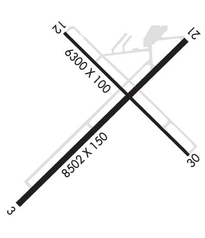
| Rwy | Rwy | |||||||
| 8503x150 | 8503' | 8503x150 | 8503' | |||||
| 6301x100 | 6301' | 6301x100 | 6301' | |||||
| Runway ID | Single Wheel | Double Wheel | Double Tandem Wheel | Dual Double Wheel |
| 03/21 | 86,000 | 105,000 | 160,000 | N/A |
| 12/30 | 86,000 | 105,000 | 160,000 | N/A |
| These numbers are Advisory and are not limits. The Airport Manager should have more accurate Weight Limits | ||||
 Airport Diagram might not be current. | |
| Facility Name: | LARAMIE RGNL |
| City Name: | LARAMIE |
| County: | ALBANY |
| State abbrev: | WY |
| State Name: | WYOMING |
| Ownership: | PUBLICLY OWNED |
| Use: | OPEN TO THE PUBLIC |
| Owner's Name: | LARAMIE REGIONAL AIRPORT BOARD |
| Address: | 555 GENERAL BREES RD |
| LARAMIE, WY 82070 | |
| Owner's Phone: | 307-742-4164 |
| Manager's Name: | AMY TERRELL |
| Address: | 555 GENERAL BREES RD |
| LARAMIE, WY 82070 | |
| Phone: | 307-742-4164 |
| FAA Region: | NORTHWEST MOUNTAIN |
| FAA Field Office: | DEN |
| Date | Sunrise | Sunset |
|---|---|---|
| 06/08/26 Monday | 5:30 | 20:34 |
| 06/09/26 Tuesday | 5:29 | 20:35 |
| 06/10/26 Wednesday | 5:29 | 20:35 |
| 06/11/26 Thursday | 5:29 | 20:36 |
| 06/12/26 Friday | 5:29 | 20:36 |
| 06/13/26 Saturday | 5:29 | 20:37 |
| 06/14/26 Sunday | 5:29 | 20:37 |
| 06/15/26 Monday | 5:29 | 20:38 |
| 06/16/26 Tuesday | 5:29 | 20:38 |
| 06/17/26 Wednesday | 5:29 | 20:38 |
| 06/18/26 Thursday | 5:29 | 20:39 |
| 06/19/26 Friday | 5:29 | 20:39 |
| 06/20/26 Saturday | 5:29 | 20:39 |
| 06/21/26 Sunday | 5:30 | 20:39 |
| Airport Attendance Schedule | MAY-SEPT 7 Days A Week 0700-1900, OCT - APR 7 Days A Week 0600-1900 |
| Airport Status | OPERATIONAL (This Status can change at any time - please check NOTAMS) |
| Airport Lighting Schedule | ACTVT ODALS RWY 30; REIL RWY 03, 21 & 12; PAPI RWY 03, 12, 21, & 30; MIRL RWY 03/21 & RWY 12/30 - CTAF. |
| Airport Storage Available | Tie Downs, Hanger |
| Extra Services Available | Air Freight, Charter, Flight Instruction, Aircraft Rental |
| Wind Indicator | YES - (lighted) |
| Control Tower | NO |
| CTAF Frequency | 123.050 |
| Unicom Frequency | 123.050 |
| Rotating Beacon Color | WG |
| Segmented Circle | YES |
| Landing Fee | YES |
| Airport Inspected | FEDERAL - performed by FAA AIRPORTS FIELD PERSONNEL |
| Inspection Date | 02/25/2026 |
| Type of Fuel Available | Grade 100LL, JET A (freeze point -40C) |
| Airframe Repair Service | NONE |
| Power Plant Repair Service | NONE |
| Latitude | N4118.7 |
| Longitude | W10540.5 (ESTIMATED) |
| Arpt Elevation | 7283ft (SURVEYED) |
| Magnetic Variation | 13E |
| 3 miles W | of LARAMIE |
| Traffic Pattern Altitude | |
| Sectional Chart | CHEYENNE |
| Operations (Reported) | Yearly | Avg. Daily |
|---|---|---|
| General Aviation Transient | 0 | 0 |
| General Aviation Local | 0 | 0 |
| Air Taxi | 0 | 0 |
| Commerical | 0 | 0 |
| Commuter | 0 | 0 |
| Military | 0 | 0 |
| Aircraft based on Field | |
|---|---|
| General Aviation Singles | 0 |
| General Aviation Multi | 0 |
| Jet Aircraft | 0 |
| General Aviation Helicopters | 0 |
| Military Aircraft | 0 |
| Gliders | 0 |
| Ultralights | 0 |
| FSS on field | NO |
| FSS tie-in | CASPER |
| FSS Phone | 1-800-WX-BRIEF |
| Who issues Notams | LAR |
| Notam D service at airport | YES |
| ARTCC Name | DENVER |
| Airport Certification | AIRPORT RECEIVING SCHEDULED AIR CARRIER SERVICE FROM CARRIERS CERTIFICATED BY THE CIVIL AERONAUTICS BOARD; INDEX B AVBL UPON REQ. |
| Aircraft Rescue & Firefighting Index | AIRPORT HAS A CERTIFICATE UNDER CFR PART 139 |
| Airport of Entry | No |
| Custom Landing Rights | No |
| Joint Civil/Military | No |
| Military Landing rights | YES |
| NATIONAL PLAN OF INTEGRATED AIRPORT SYSTEMS (NPIAS) |
| GRANT AGREEMENTS UNDER FAAP/ADAP/AIP |
| ASSURANCES PURSUANT TO TITLE VI, CIVIL RIGHTS ACT OF 1964 |
| AGREEMENT UNDER DLAND OR DCLA HAS EXPIRED. |
| AFLD SFC COND UNMNTD 2200-0500. |
| FOR CD CTC DENVER ARTCC ON FREQ. IF UNA, CTC FSS ON FREQ VIA RCO. IF UNA, CTC DENVER ARTCC AT 303-651-4257. |
| RWY 03/2 1 PCR VALUE: 320/F/C/X/T |
| RWY 12/3 0 PCR VALUE: 350/F/C/X/T |
Airport Communications & Frequencies:
| |||||||||
| Runway: 03 | Runway: 21 | ||
| Mag heading: | 33° | Mag heading: | 213° |
| Rwy Slope: | -.14% Down | Rwy Slope: | .14% Up |
| Approach: | Approach: | ||
| Pattern: | Left Traffic | Pattern: | Left Traffic |
| Markings: | NONPRECISION INSTRUMENT | Markings: | NONPRECISION INSTRUMENT |
| Marking Condition: | GOOD | Marking Condition: | GOOD |
| Arresting Dev: | Arresting Dev: | ||
| Lat & Long: | N4118.2 W10541.2 | Lat. & Long.: | N4119.1 W10539.9 |
| Elev: | 7283.4 ft. MSL | Elev: | 7271.6 ft. MSL |
| TCH: | 32 ft. AGL | TCH: | 53 ft. AGL |
| Visual Glide Path: | 3.00 degrees | Visual Glide Path: | 3.00 degrees |
| Displaced Threshold: | No | Displaced Threshold: | No |
| Touchdown Zone: | YES | Touchdown Zone: | YES |
| Touchdown Elev.: | 7283.7 feet | Touchdown Elev.: | 7277.5 feet |
| Visual Glide Slope: | 4-Light PAPI on LEFT side of Runway | Visual Glide Slope: | 4-Light PAPI on LEFT side of Runway |
| RVR Equipment: | RVR Equipment: | ||
| RVV Equipment: | NO | RVV Equipment: | NO |
| Approach Lights: | Approach Lights: | ||
| REIL: | YES | REIL: | YES |
| Centerline Lights: | NO | Centerline Lights: | NO |
| Touchdown lights: | NO | Touchdown lights: | NO |
| Runway Category: | Runway with a Non-precision Approach having visibility minimums greater than 3/4 mile | Runway Category: | Runway with a Non-precision Approach having visibility minimums greater than 3/4 mile |
| Declared Distances: | TORA:8503' TODA:8503' ASDA:8503' LDA:8503' | Declared Distances: | TORA:8503' TODA:8503' ASDA:8503' LDA:8503' |
| Runway: 12 | Runway: 30 | ||
| Mag heading: | 122° | Mag heading: | 302° |
| Rwy Slope: | .02% Up | Rwy Slope: | -.02% Down |
| Approach: | Approach: | ||
| Pattern: | Left Traffic | Pattern: | Left Traffic |
| Markings: | NONPRECISION INSTRUMENT | Markings: | NONPRECISION INSTRUMENT |
| Marking Condition: | GOOD | Marking Condition: | GOOD |
| Arresting Dev: | Arresting Dev: | ||
| Lat & Long: | N4119.2 W10540.9 | Lat. & Long.: | N4118.5 W10539.9 |
| Elev: | 7273.4 ft. MSL | Elev: | 7274.8 ft. MSL |
| TCH: | 44 ft. AGL | TCH: | 41 ft. AGL |
| Visual Glide Path: | 3.00 degrees | Visual Glide Path: | 3.00 degrees |
| Displaced Threshold: | No | Displaced Threshold: | No |
| Touchdown Zone: | YES | Touchdown Zone: | YES |
| Touchdown Elev.: | 7275.4 feet | Touchdown Elev.: | 7278.3 feet |
| Visual Glide Slope: | 4-Light PAPI on LEFT side of Runway | Visual Glide Slope: | 4-Light PAPI on LEFT side of Runway |
| RVR Equipment: | RVR Equipment: | ||
| RVV Equipment: | NO | RVV Equipment: | NO |
| Approach Lights: | Approach Lights: | ODALS - omnidirectional approach lighting system | |
| REIL: | YES | REIL: | NO |
| Centerline Lights: | NO | Centerline Lights: | NO |
| Touchdown lights: | NO | Touchdown lights: | NO |
| Runway Category: | Runway with a Non-precision Approach having visibility minimums greater than 3/4 mile | Runway Category: | Runway with a Non-precision Approach having visibility minimums greater than 3/4 mile |
| Declared Distances: | TORA:6301' TODA:6301' ASDA:6301' LDA:6301' | Declared Distances: | TORA:6301' TODA:6301' ASDA:6301' LDA:6301' |
Thanks for using FltPlan.com
all rights reserved © 1999-2026 by Flight Plan LLC
