| PURDUE UNIVERSITY LAFAYETTE IN |
| |
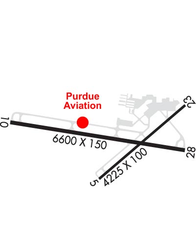
| Lat: N 4024.7 Long: W 08656.2 Elev: 606 Var: +01 Longest Runway: 6600 | ||
| Dept. ATIS: 127.75 Arr. ATIS: 127.75 AWOS: 127.75 Ground: 121.9 Tower: 119.6 | ||
| ||||||||||||||||||||||||||||||||||||||||||||||||||||||||||||||||||||
| ||||||||||||||||||||||||||||||||||||||||||||||||||||||||||||||||||||
| ||||||||||||||||||||||||||||||||||||||||||||||||||||||||||||||||||||
| Rwy | Rwy | |||||||
| 4225x100 | 4225' | 4225x100 | 3902' | |||||
| 6600x150 | 6600' | 110.30 - 100° | 6600x150 | 6600' | ||||
| Runway ID | Single Wheel | Double Wheel | Double Tandem Wheel | Dual Double Wheel |
| 05/23 | 48,000 | 58,000 | 90,000 | N/A |
| 10/28 | 90,000 | 110,000 | 165,000 | N/A |
| These numbers are Advisory and are not limits. The Airport Manager should have more accurate Weight Limits | ||||
 Airport Diagram might not be current. | |
| Facility Name: | PURDUE UNIVERSITY |
| City Name: | LAFAYETTE |
| County: | TIPPECANOE |
| State abbrev: | IN |
| State Name: | INDIANA |
| Ownership: | PUBLICLY OWNED |
| Use: | OPEN TO THE PUBLIC |
| Owner's Name: | PURDUE UNIVERSITY |
| Address: | 1501 AVIATION DRIVE, TRML BLDG ROOM 201 |
| WEST LAFAYETTE, IN 47907 | |
| Owner's Phone: | (765) 496-6326 |
| Manager's Name: | ADAM BAXMEYER |
| Address: | 1501 AVIATION DRIVE, TRML BLDG ROOM 201 |
| WEST LAFAYETTE, IN 47907 | |
| Phone: | (765) 496-6850 |
| FAA Region: | GREAT LAKES |
| FAA Field Office: | CHI |

| Date | Sunrise | Sunset |
|---|---|---|
| 06/08/26 Monday | 6:18 | 21:16 |
| 06/09/26 Tuesday | 6:17 | 21:17 |
| 06/10/26 Wednesday | 6:17 | 21:17 |
| 06/11/26 Thursday | 6:17 | 21:18 |
| 06/12/26 Friday | 6:17 | 21:18 |
| 06/13/26 Saturday | 6:17 | 21:19 |
| 06/14/26 Sunday | 6:17 | 21:19 |
| 06/15/26 Monday | 6:17 | 21:20 |
| 06/16/26 Tuesday | 6:17 | 21:20 |
| 06/17/26 Wednesday | 6:17 | 21:20 |
| 06/18/26 Thursday | 6:17 | 21:21 |
| 06/19/26 Friday | 6:17 | 21:21 |
| 06/20/26 Saturday | 6:17 | 21:21 |
| 06/21/26 Sunday | 6:18 | 21:21 |
| Airport Attendance Schedule | MON-FRI 0800-1700 |
| Airport Status | OPERATIONAL (This Status can change at any time - please check NOTAMS) |
| Airport Lighting Schedule | WHEN ATCT CLSD ACTVT MALSR RWY 10; REIL RWY 5, 23 & 28; MIRL RWY 5/23; HIRL RWY 10/28 - CTAF. |
| Airport Storage Available | Tie Downs, Hanger |
| Extra Services Available | Air Ambulance, Avionics, Charter, Aircraft Rental, Aircraft Sales |
| Wind Indicator | YES - (lighted) |
| Control Tower | YES |
| CTAF Frequency | 119.600 |
| Unicom Frequency | 122.950 |
| Rotating Beacon Color | WG |
| Segmented Circle | NO |
| Landing Fee | NO |
| Airport Inspected | FEDERAL - performed by FAA AIRPORTS FIELD PERSONNEL |
| Inspection Date | 11/13/2024 |
| Type of Fuel Available | Grade 100LL, JET A (freeze point -40C) |
| Airframe Repair Service | MAJOR |
| Power Plant Repair Service | MAJOR |
| Latitude | N4024.7 |
| Longitude | W08656.2 (ESTIMATED) |
| Arpt Elevation | 605ft (SURVEYED) |
| Magnetic Variation | 01W |
| 2 miles SW | of LAFAYETTE |
| Traffic Pattern Altitude | |
| Sectional Chart | CHICAGO |
| Operations (Reported) | Yearly | Avg. Daily |
|---|---|---|
| General Aviation Transient | 0 | 0 |
| General Aviation Local | 0 | 0 |
| Air Taxi | 0 | 0 |
| Commerical | 0 | 0 |
| Commuter | 0 | 0 |
| Military | 0 | 0 |
| Aircraft based on Field | |
|---|---|
| General Aviation Singles | 0 |
| General Aviation Multi | 0 |
| Jet Aircraft | 0 |
| General Aviation Helicopters | 0 |
| Military Aircraft | 0 |
| Gliders | 0 |
| Ultralights | 0 |
| FSS on field | NO |
| FSS tie-in | TERRE HAUTE |
| FSS Phone | 1-800-WX-BRIEF |
| Who issues Notams | LAF |
| Notam D service at airport | YES |
| ARTCC Name | CHICAGO |
| Airport Certification | UNSKED ACR OPS GTR THAN 30 PAX SEATS PPR - 765-496-6326 OR 765-496-4057. INDEX B ARFF CPBLY AVBL ON REQ. |
| Aircraft Rescue & Firefighting Index | AIRPORT HAS A CERTIFICATE UNDER CFR PART 139 |
| Airport of Entry | No |
| Custom Landing Rights | No |
| Joint Civil/Military | No |
| Military Landing rights | YES |
| NATIONAL PLAN OF INTEGRATED AIRPORT SYSTEMS (NPIAS) |
| GRANT AGREEMENTS UNDER FAAP/ADAP/AIP |
| ASSURANCES PURSUANT TO TITLE VI, CIVIL RIGHTS ACT OF 1964 |
| TRNG OPS & BIRDS INVOF ARPT. |
| SFC COND UNMNT 2200-0600 OR WKEND. |
| FOR CD IF UNA TO CTC ON FSS FREQ, CTC CHICAGO ARTCC AT 630-906-8921. |
| RWY 05/2 3 RWY 05/23 NOT AVBL FOR PART 121/PART 380 OPS WITH SKED PAX CARRYING OPS MORE THAN 9 PAX SEATS AND NON-SKED PAX CARRYING OPS MORE THAN 30 PAX SEATS. WINGSPAN GTR THAN 79 FT NA. |
| RWY 05/2 3 PCR VALUE: 80/F/D/X/T |
| RWY 10/2 8 PCR VALUE: 470/F/D/X/T |
Airport Communications & Frequencies:
| |||||||||||||||||||||||||||||
| Runway: 05 | Runway: 23 | ||
| Mag heading: | 51° | Mag heading: | 231° |
| Rwy Slope: | .31% Up | Rwy Slope: | -.31% Down |
| Approach: | Approach: | ||
| Pattern: | Left Traffic | Pattern: | Left Traffic |
| Markings: | BASIC | Markings: | BASIC |
| Marking Condition: | FAIR | Marking Condition: | GOOD |
| Arresting Dev: | Arresting Dev: | ||
| Lat & Long: | N4024.5 W08656.3 | Lat. & Long.: | N4024.9 W08655.6 |
| Elev: | 592.5 ft. MSL | Elev: | 605.7 ft. MSL |
| TCH: | 42 ft. AGL | TCH: | 43 ft. AGL |
| Visual Glide Path: | 3.00 degrees | Visual Glide Path: | 3.00 degrees |
| Displaced Threshold: | No | Displaced Threshold: | 323 feet |
| Touchdown Zone: | YES | Touchdown Zone: | YES |
| Touchdown Elev.: | 597.0 feet | Touchdown Elev.: | 602.7 feet |
| Visual Glide Slope: | 2-Light PAPI on LEFT side of Runway | Visual Glide Slope: | 2-Light PAPI on LEFT side of Runway |
| RVR Equipment: | RVR Equipment: | ||
| RVV Equipment: | NO | RVV Equipment: | NO |
| Approach Lights: | Approach Lights: | ||
| REIL: | YES | REIL: | YES |
| Centerline Lights: | NO | Centerline Lights: | NO |
| Touchdown lights: | NO | Touchdown lights: | NO |
| Runway Category: | Runway with a Visual Approach | Runway Category: | Runway with a Visual Approach |
| Declared Distances: | TORA:4225' TODA:4225' ASDA:4225' LDA:4225' | Declared Distances: | TORA:4225' TODA:4225' ASDA:4225' LDA:3912' |
| Obstructions: | Obstructions: | FENCE | |
| Marked: | Marked: | NOT Marked/Lighted | |
| Clearance slope: | 50:1 | Clearance slope: | 7:1; 20:1 AT DSPLCD THR. |
| Obstruction height: | Obstruction height: | 11 feet AGL | |
| Dist. from runway: | Dist. from runway: | 287 feet | |
| Centerline offset: | Centerline offset: | 132 feet left of centerline | |
| Comments: | Comments: |
| Runway: 10 | Runway: 28 | ||
| Mag heading: | 100° | Mag heading: | 280° |
| Rwy Slope: | -.03% Down | Rwy Slope: | .03% Up |
| Approach: | ILS | Approach: | |
| Pattern: | Left Traffic | Pattern: | Left Traffic |
| Markings: | PRECISION INSTRUMENT | Markings: | PRECISION INSTRUMENT |
| Marking Condition: | FAIR | Marking Condition: | FAIR |
| Arresting Dev: | Arresting Dev: | ||
| Lat & Long: | N4024.8 W08657.1 | Lat. & Long.: | N4024.7 W08655.7 |
| Elev: | 600.1 ft. MSL | Elev: | 597.8 ft. MSL |
| TCH: | 50 ft. AGL | TCH: | 46 ft. AGL |
| Visual Glide Path: | 3.00 degrees | Visual Glide Path: | 3.00 degrees |
| Displaced Threshold: | No | Displaced Threshold: | No |
| Touchdown Zone: | YES | Touchdown Zone: | YES |
| Touchdown Elev.: | 600.6 feet | Touchdown Elev.: | 597.8 feet |
| Visual Glide Slope: | 4-Light PAPI on LEFT side of Runway; PAPI UNUSBL BYD 9 DEGS RIGHT OF CNTRLN. | Visual Glide Slope: | 4-BOX VASI ON RIGHT SIDE OF RUNWAY |
| RVR Equipment: | RVR Equipment: | ||
| RVV Equipment: | NO | RVV Equipment: | NO |
| Approach Lights: | MALSR - 1,400 foot medium intensity approach lighting system with runway alignment indicator lights | Approach Lights: | |
| REIL: | NO | REIL: | YES |
| Centerline Lights: | NO | Centerline Lights: | NO |
| Touchdown lights: | NO | Touchdown lights: | NO |
| Runway Category: | Precision Instrument Runway | Runway Category: | Runway with a Non-precision Approach having visibility minimums greater than 3/4 mile |
| Declared Distances: | TORA:6600' TODA:6600' ASDA:6600' LDA:6600' | Declared Distances: | TORA:6600' TODA:6600' ASDA:6600' LDA:6600' |
| Obstructions: | TREES | Obstructions: | TREES |
| Marked: | NOT Marked/Lighted | Marked: | NOT Marked/Lighted |
| Clearance slope: | 32:1 | Clearance slope: | 40:1 |
| Obstruction height: | 97 feet AGL | Obstruction height: | 51 feet AGL |
| Dist. from runway: | 3381 feet | Dist. from runway: | 2057 feet |
| Centerline offset: | 968 left of centerline | Centerline offset: | 439 feet right of centerline |
| Comments: | Comments: |
Thanks for using FltPlan.com
all rights reserved © 1999-2026 by Flight Plan LLC