
| PERRIS VALLEY PERRIS CA |
| |
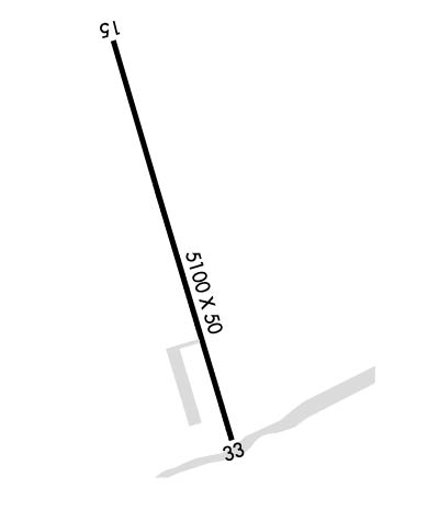
| Lat: N 3345.9 Long: W 11713.1 Elev: 1413 Var: -14 Longest Runway: 5100 | ||
| CTAF: 122.77 | ||
| ||||||||||||||||||||||||||||||||
| ||||||||||||||||||||||||||||||||
| Rwy | Rwy | |||||||
| 5100x50 | 3200' | 5100x50 | 4956' | |||||
| Runway ID | Single Wheel | Double Wheel | Double Tandem Wheel | Dual Double Wheel |
| 15/33 | N/A | N/A | N/A | N/A |
| These numbers are Advisory and are not limits. The Airport Manager should have more accurate Weight Limits | ||||
| FltPlan does not have IFR approach charts available for KL65. |
 Airport Diagram might not be current. | |
| Facility Name: | PERRIS VALLEY |
| City Name: | PERRIS |
| County: | RIVERSIDE |
| State abbrev: | CA |
| State Name: | CALIFORNIA |
| Ownership: | PRIVATELY OWNED |
| Use: | OPEN TO THE PUBLIC |
| Owner's Name: | B & D CONATSER |
| Address: | 2091 GOETZ ROAD |
| PERRIS, CA 92570 | |
| Owner's Phone: | 951-657-3904 |
| Manager's Name: | PAT CONATSER |
| Address: | P.O. BOX 1823 |
| PERRIS, CA 92370 | |
| Phone: | 951-657-1664; MAIN OFFICE TO LEAVE MSGS W/SECY - (951) 657-3904 FAX: (951) 657-6178. EMAIL: PERRISAIR@AOL.COM |
| FAA Region: | WESTERN-PACIFIC |
| FAA Field Office: | LAX |
| Date | Sunrise | Sunset |
|---|---|---|
| 09/24/21 Friday | 6:38 | 18:43 |
| 09/25/21 Saturday | 6:39 | 18:42 |
| 09/26/21 Sunday | 6:40 | 18:40 |
| 09/27/21 Monday | 6:40 | 18:39 |
| 09/28/21 Tuesday | 6:41 | 18:37 |
| 09/29/21 Wednesday | 6:42 | 18:36 |
| 09/30/21 Thursday | 6:42 | 18:35 |
| 10/01/21 Friday | 6:43 | 18:33 |
| 10/02/21 Saturday | 6:44 | 18:32 |
| 10/03/21 Sunday | 6:45 | 18:31 |
| 10/04/21 Monday | 6:45 | 18:29 |
| 10/05/21 Tuesday | 6:46 | 18:28 |
| 10/06/21 Wednesday | 6:47 | 18:27 |
| 10/07/21 Thursday | 6:48 | 18:25 |
| Airport Attendance Schedule | 7 Days A Week DAWN-DUSK |
| Airport Status | OPERATIONAL (This Status can change at any time - please check NOTAMS) |
| Airport Lighting Schedule | |
| Airport Storage Available | Tie Downs |
| Extra Services Available | Charter, Parachute Jumping |
| Wind Indicator | YES - (unlit) |
| Control Tower | NO |
| CTAF Frequency | 122.775 |
| Unicom Frequency | |
| Rotating Beacon Color | |
| Segmented Circle | YES |
| Landing Fee | NO |
| Airport Inspected | STATE - performed by STATE AERONAUTICAL PERSONNEL |
| Inspection Date | 04/12/2021 |
| Type of Fuel Available | Grade 100LL, JET A (freeze point -40C) |
| Airframe Repair Service | MAJOR |
| Power Plant Repair Service | MAJOR |
| Latitude | N3345.9 |
| Longitude | W11713.1 (ESTIMATED) |
| Arpt Elevation | 1413ft (ESTIMATED) |
| Magnetic Variation | 14E |
| 1 miles SE | of PERRIS |
| Traffic Pattern Altitude | |
| Sectional Chart | LOS ANGELES |
| Operations (Reported) | Yearly | Avg. Daily |
|---|---|---|
| General Aviation Transient | 1750 | 5 |
| General Aviation Local | 17500 | 48 |
| Air Taxi | 0 | 0 |
| Commerical | 0 | 0 |
| Commuter | 0 | 0 |
| Military | 35 | 0 |
| Aircraft based on Field | |
|---|---|
| General Aviation Singles | 10 |
| General Aviation Multi | 11 |
| Jet Aircraft | 1 |
| General Aviation Helicopters | 0 |
| Military Aircraft | 0 |
| Gliders | 0 |
| Ultralights | 35 |
| FSS on field | NO |
| FSS tie-in | RIVERSIDE |
| FSS Phone | 1-800-WX-BRIEF |
| Who issues Notams | RAL |
| Notam D service at airport | YES |
| ARTCC Name | LOS ANGELES |
| Airport Certification | |
| Aircraft Rescue & Firefighting Index | None |
| Airport of Entry | No |
| Custom Landing Rights | No |
| Joint Civil/Military | No |
| Military Landing rights | No |
| EXTSV ULTRALIGHT & PARACHUTING ACTIVITIES DAILY; DO NOT OVERFLY AIRPORT; AVOID AIRSPACE ADJ EAST. ULTRALIGHTS ON & INVOF ARPT. ULTRALIGHT AND PARACHUTING ACTIVITIES CAN BE MONITORED ON FREQ 122.775. |
| (A70) FUEL AVBL FOR EMERG USE ONLY. |
| FOR CD CTC SOCAL APCH AT 800-448-3724. |
| Runway: 15 | Runway: 33 | ||
| Mag heading: | N/A | Mag heading: | N/A |
| Approach: | Approach: | ||
| Pattern: | Right Traffic | Pattern: | Left Traffic |
| Markings: | BASIC | Markings: | BASIC |
| Marking Condition: | GOOD | Marking Condition: | GOOD |
| Arresting Dev: | Arresting Dev: | ||
| Lat & Long: | N3346.3 W11713.3 | Lat. & Long.: | N3345.5 W11713.0 |
| Elev: | 1413.0 ft. MSL | Elev: | N/A |
| TCH: | TCH: | ||
| Visual Glide Path: | Visual Glide Path: | ||
| Displaced Threshold: | 1900 feet | Displaced Threshold: | 144 feet |
| Touchdown Zone: | NO | Touchdown Zone: | NO |
| Touchdown Elev.: | Touchdown Elev.: | ||
| Visual Glide Slope: | Visual Glide Slope: | ||
| RVR Equipment: | RVR Equipment: | ||
| RVV Equipment: | NO | RVV Equipment: | NO |
| Approach Lights: | Approach Lights: | ||
| REIL: | NO | REIL: | NO |
| Centerline Lights: | NO | Centerline Lights: | NO |
| Touchdown lights: | NO | Touchdown lights: | NO |
| Runway Category: | Runway with a Visual Approach | Runway Category: | Runway with a Visual Approach |
| Declared Distances: | Declared Distances: | ||
| Obstructions: | TREES | Obstructions: | |
| Marked: | NOT Marked/Lighted | Marked: | |
| Clearance slope: | 5:1; APCH RATIO TO DSPLCD THR 20:1. | Clearance slope: | 20:1; APCH RATIO TO DSPLCD THLD 20:1. |
| Obstruction height: | 30 feet AGL | Obstruction height: | |
| Dist. from runway: | 150 feet | Dist. from runway: | |
| Centerline offset: | Centerline offset: | ||
| Comments: | Comments: |
Thanks for using FltPlan.com
all rights reserved © 1999-2021 by Flight Plan LLC
