
| LEESVILLE LEESVILLE LA |
| |
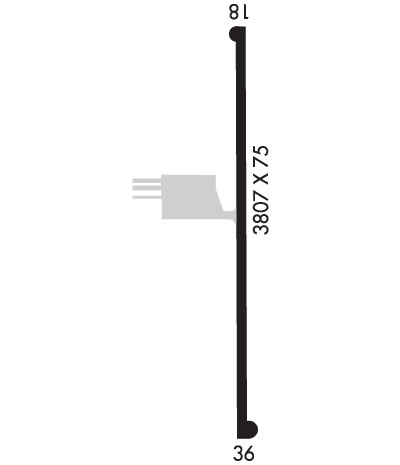
| Lat: N 3110.1 Long: W 09320.5 Elev: 282 Var: -02 Longest Runway: 3807 | ||
| CTAF: 122.8 | ||
| ||||||
|
| Rwy | Rwy | |||||||
| 3807x75 | 3807' | 3807x75 | 3807' | |||||
| Runway ID | Single Wheel | Double Wheel | Double Tandem Wheel | Dual Double Wheel |
| 18/36 | 31,000 | 47,000 | N/A | N/A |
| These numbers are Advisory and are not limits. The Airport Manager should have more accurate Weight Limits | ||||
 Airport Diagram might not be current. | |
| Facility Name: | LEESVILLE |
| City Name: | LEESVILLE |
| County: | VERNON |
| State abbrev: | LA |
| State Name: | LOUISIANA |
| Ownership: | PUBLICLY OWNED |
| Use: | OPEN TO THE PUBLIC |
| Owner's Name: | CITY OF LEESVILLE |
| Address: | 508 SOUTH 5TH ST |
| LEESVILLE, LA 71446 | |
| Owner's Phone: | 337-239-2444 |
| Manager's Name: | PAUL JACKSON |
| Address: | 424 AIRPORT ROAD |
| LEESVILLE, LA 71446 | |
| Phone: | 337-238-5968 |
| FAA Region: | SOUTHWEST |
| FAA Field Office: | LNM |
| Date | Sunrise | Sunset |
|---|---|---|
| 06/08/26 Monday | 6:09 | 20:16 |
| 06/09/26 Tuesday | 6:09 | 20:16 |
| 06/10/26 Wednesday | 6:09 | 20:17 |
| 06/11/26 Thursday | 6:09 | 20:17 |
| 06/12/26 Friday | 6:09 | 20:18 |
| 06/13/26 Saturday | 6:09 | 20:18 |
| 06/14/26 Sunday | 6:09 | 20:18 |
| 06/15/26 Monday | 6:09 | 20:19 |
| 06/16/26 Tuesday | 6:09 | 20:19 |
| 06/17/26 Wednesday | 6:09 | 20:19 |
| 06/18/26 Thursday | 6:09 | 20:20 |
| 06/19/26 Friday | 6:09 | 20:20 |
| 06/20/26 Saturday | 6:10 | 20:20 |
| 06/21/26 Sunday | 6:10 | 20:20 |
| Airport Attendance Schedule | CONTINUOUS; FUEL, RESTROOM & TERMINAL LOBBY AVAILABLE 24/7. MANAGER HOURS PART-TIME ON CALL. |
| Airport Status | OPERATIONAL (This Status can change at any time - please check NOTAMS) |
| Airport Lighting Schedule | DUSK-DAWN. MIRL RWY 18/36, REIL RYS 18 & 36 PRESET LOW INTST DUSK-DAWN; TO INCR INTST ACTVT - CTAF 122.8. |
| Airport Storage Available | Tie Downs, Hanger |
| Extra Services Available | Flight Instruction |
| Wind Indicator | YES - (lighted) |
| Control Tower | NO |
| CTAF Frequency | 122.800 |
| Unicom Frequency | 122.800 |
| Rotating Beacon Color | WG |
| Segmented Circle | NO |
| Landing Fee | NO |
| Airport Inspected | STATE - performed by STATE AERONAUTICAL PERSONNEL |
| Inspection Date | 10/10/2023 |
| Type of Fuel Available | Grade 100LL, JET A (freeze point -40C); -10FUEL AVBL 24 HRS WITH CREDIT CARD. |
| Airframe Repair Service | None |
| Power Plant Repair Service | None |
| Latitude | N3110.1 |
| Longitude | W09320.5 (ESTIMATED) |
| Arpt Elevation | 281ft (SURVEYED) |
| Magnetic Variation | 02E |
| 4 miles W | of LEESVILLE |
| Traffic Pattern Altitude | |
| Sectional Chart | HOUSTON |
| Operations (Reported) | Yearly | Avg. Daily |
|---|---|---|
| General Aviation Transient | 0 | 0 |
| General Aviation Local | 0 | 0 |
| Air Taxi | 0 | 0 |
| Commerical | 0 | 0 |
| Commuter | 0 | 0 |
| Military | 0 | 0 |
| Aircraft based on Field | |
|---|---|
| General Aviation Singles | 0 |
| General Aviation Multi | 0 |
| Jet Aircraft | 0 |
| General Aviation Helicopters | 0 |
| Military Aircraft | 0 |
| Gliders | 0 |
| Ultralights | 0 |
| FSS on field | NO |
| FSS tie-in | DE RIDDER |
| FSS Phone | 1-800-WX-BRIEF |
| Who issues Notams | DRI |
| Notam D service at airport | YES |
| ARTCC Name | HOUSTON |
| Airport Certification | |
| Aircraft Rescue & Firefighting Index | None |
| Airport of Entry | No |
| Custom Landing Rights | No |
| Joint Civil/Military | No |
| Military Landing rights | YES |
| NATIONAL PLAN OF INTEGRATED AIRPORT SYSTEMS (NPIAS) |
| GRANT AGREEMENTS UNDER FAAP/ADAP/AIP |
| ASSURANCES PURSUANT TO TITLE VI, CIVIL RIGHTS ACT OF 1964 |
| RWY 18/36 15 FT TERRAIN DROP EAST SIDE OF RWY. |
| WILDLIFE ON & INVOF ARPT. |
| USE RWY END TURNABOUTS TO AVOID LOCKED WHEEL AND SHARP TURNS ON RWY SFC. |
| FOR CD CTC MAKS APCH AT 726-780-0456. |
| CTC ARPT MGR FOR DSNGD RAMP SPACE FOR PUB USE AT ARPT |
Airport Communications & Frequencies:
| ||||||||||||||
| Runway: 18 | Runway: 36 | ||
| Mag heading: | 178° | Mag heading: | 358° |
| Rwy Slope: | -.39% Down | Rwy Slope: | .39% Up |
| Approach: | Approach: | ||
| Pattern: | Left Traffic | Pattern: | Left Traffic |
| Markings: | NONPRECISION INSTRUMENT | Markings: | NONPRECISION INSTRUMENT |
| Marking Condition: | GOOD | Marking Condition: | GOOD |
| Arresting Dev: | Arresting Dev: | ||
| Lat & Long: | N3110.4 W09320.5 | Lat. & Long.: | N3109.8 W09320.5 |
| Elev: | 281.0 ft. MSL | Elev: | 266.0 ft. MSL |
| TCH: | 48 ft. AGL | TCH: | 54 ft. AGL |
| Visual Glide Path: | 3.00 degrees | Visual Glide Path: | 3.00 degrees |
| Displaced Threshold: | No | Displaced Threshold: | No |
| Touchdown Zone: | YES | Touchdown Zone: | YES |
| Touchdown Elev.: | 281.5 feet | Touchdown Elev.: | 279.7 feet |
| Visual Glide Slope: | 2-Light PAPI on LEFT side of Runway | Visual Glide Slope: | 2-Light PAPI on LEFT side of Runway |
| RVR Equipment: | RVR Equipment: | ||
| RVV Equipment: | NO | RVV Equipment: | NO |
| Approach Lights: | Approach Lights: | ||
| REIL: | YES | REIL: | YES |
| Centerline Lights: | NO | Centerline Lights: | NO |
| Touchdown lights: | NO | Touchdown lights: | NO |
| Runway Category: | Runway with a Non-precision Approach | Runway Category: | Runway with a Non-precision Approach |
| Declared Distances: | Declared Distances: | ||
| Obstructions: | TREES | Obstructions: | TREES |
| Marked: | NOT Marked/Lighted | Marked: | NOT Marked/Lighted |
| Clearance slope: | 50:1 | Clearance slope: | 36:1 |
| Obstruction height: | 58 feet AGL | Obstruction height: | 39 feet AGL |
| Dist. from runway: | 872 feet | Dist. from runway: | 1596 feet |
| Centerline offset: | Centerline offset: | 493 feet right of centerline | |
| Comments: | Comments: |
Thanks for using FltPlan.com
all rights reserved © 1999-2026 by Flight Plan LLC
