NOTICE: Information listed below may not be current.Airport Ident: KL38
| Airport Name: LOUISIANA RGNL, LOUISIANA
Latitude: N3010.4 Longitude: W09056.4
Field Elevation: 15' Variation: E1° as of 01/06
Daylight Savings: First Sunday in April at 0200 to last Sunday in October at 0200 local time (Exception Arizona and that portion of Indiana in the Eastern Time Zone)
Customs: N/A
|
|
| DISTANCE from: | KTEB to KL38 = 1041 nm
| KMIA to KL38 = 622 nm
| KORD to KL38 = 724 nm
| KDAL to KL38 = 343 nm
| KSEA to KL38 = 1777 nm
| KLAX to KL38 = 1411 nm
|
|
| AIRPORT TYPE: | | Active airports having permanent type surface runways with less than the minimum facilities. |
|
Rotating Beacon: YES
|
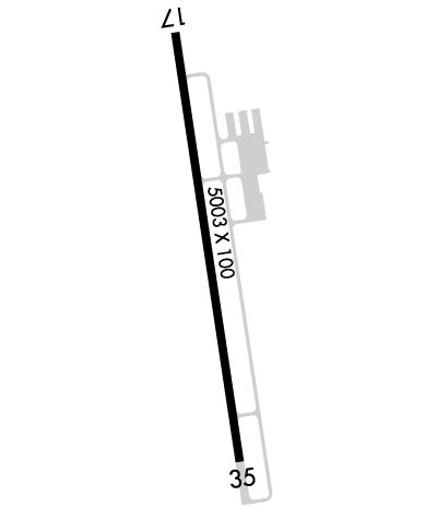
| RUNWAY INFORMATION: | Runway Ident: 35 /17
Runway Length: 4000
Runway Width: 100
Runway Surface: ASPHALT, ASPHALTIC CONCRETE, TAR MACADAM, OR BITUMEN BOUND MACADAM (INCLUDING ANY OF THESE SURFACE TYPES WITH CONCRETE ENDS).
Runway PCN Rating: -
Runway PCN Evaluation Method: N/A
Runway Open: YES
| Runway 35 Information
Runway True Heading: 351°
Takeoff Distance Available: 4000
Landing Distance Available: 4000
Runway Latitude: N3010.0
Runway Longitude: W09056.4
Runway Elevation: 14'
Runway Slope: 0°
Runway TDZE:
Runway Lighting: PCL, HIRL, REIL, PAPI
| Runway 17 Information
Runway True Heading: 171°
Takeoff Distance Available: 4000
Landing Distance Available: 4000
Runway Latitude: N3010.7
Runway Longitude: W09056.5
Runway Elevation: 14'
Runway Slope: 0°
Runway TDZE: N/A
Runway Lighting: PCL, HIRL, REIL, PAPI
|
|
|
COMMUNICATION INFORMATION
APPROACH/DEPARTURE CONTROL - BATON ROUGE APP/DEP (1100-0600Z OT ctc HOUSTON CENTER 126.35 338.25)
126.5 278.3
GROUND CONTROL OUTLET - DE RIDDER RDO
135.075
UNICOM OR CTAF/UNICOM - CTAF/UNICOM
123.0
|
COMMUNICATION REMARKS
GROUND CONTROL OUTLET - (135.075 GCO)
|
OPERATING HOURS
APPROACH/DEPARTURE CONTROL - 1100-0600Z OT ctc HOUSTON CENTER 126.35 338.25
|