
| TENSAS PARISH ST JOSEPH LA |
| |
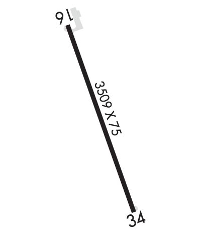
| Lat: N 3158.4 Long: W 09114.3 Elev: 74 Var: -04 Longest Runway: 3509 | ||
| CTAF: 122.9 | ||
| ||||||||||||||||||||||||||||||||
| ||||||||||||||||||||||||||||||||
| Rwy | Rwy | |||||||
| 3509x75 | 3509' | 3509x75 | 3509' | |||||
| Runway ID | Single Wheel | Double Wheel | Double Tandem Wheel | Dual Double Wheel |
| 16/34 | 12,000 | N/A | N/A | N/A |
| These numbers are Advisory and are not limits. The Airport Manager should have more accurate Weight Limits | ||||
| FltPlan does not have IFR approach charts available for KL33. |
 Airport Diagram might not be current. | |
| Facility Name: | TENSAS PARISH |
| City Name: | ST JOSEPH |
| County: | TENSAS |
| State abbrev: | LA |
| State Name: | LOUISIANA |
| Ownership: | PUBLICLY OWNED |
| Use: | OPEN TO THE PUBLIC |
| Owner's Name: | TENSAS PARISH POLICE JURY |
| Address: | PO BOX 6168 |
| ST JOSEPH, LA 71366 | |
| Owner's Phone: | 318-766-3542 |
| Manager's Name: | RON WILHITE |
| Address: | PO BOX 557 |
| ST JOSEPH, LA 71366 | |
| Phone: | (318) 537-1475 |
| FAA Region: | SOUTHWEST |
| FAA Field Office: | LNM |
| Date | Sunrise | Sunset |
|---|---|---|
| 09/24/21 Friday | 6:54 | 18:59 |
| 09/25/21 Saturday | 6:55 | 18:58 |
| 09/26/21 Sunday | 6:55 | 18:57 |
| 09/27/21 Monday | 6:56 | 18:55 |
| 09/28/21 Tuesday | 6:57 | 18:54 |
| 09/29/21 Wednesday | 6:57 | 18:53 |
| 09/30/21 Thursday | 6:58 | 18:51 |
| 10/01/21 Friday | 6:59 | 18:50 |
| 10/02/21 Saturday | 6:59 | 18:49 |
| 10/03/21 Sunday | 7:00 | 18:48 |
| 10/04/21 Monday | 7:01 | 18:46 |
| 10/05/21 Tuesday | 7:01 | 18:45 |
| 10/06/21 Wednesday | 7:02 | 18:44 |
| 10/07/21 Thursday | 7:03 | 18:42 |
| Airport Attendance Schedule | UNATTENDED; FOR ARPT ATTENDANT CALL 318-282-0348 OR 318-372-7277. |
| Airport Status | OPERATIONAL (This Status can change at any time - please check NOTAMS) |
| Airport Lighting Schedule | MIRL RY 16/34 PRESET LOW INTST; TO INCR INTST ACTVT - CTAF. |
| Airport Storage Available | Tie Downs |
| Extra Services Available | Air Ambulance |
| Wind Indicator | YES - (lighted) |
| Control Tower | NO |
| CTAF Frequency | 122.900 |
| Unicom Frequency | |
| Rotating Beacon Color | CLEAR-GREEN (Light Land Airport) |
| Segmented Circle | YES |
| Landing Fee | NO |
| Airport Inspected | STATE - performed by STATE AERONAUTICAL PERSONNEL |
| Inspection Date | 03/09/2021 |
| Type of Fuel Available | Grade 100LL |
| Airframe Repair Service | None |
| Power Plant Repair Service | None |
| Latitude | N3158.4 |
| Longitude | W09114.3 (ESTIMATED) |
| Arpt Elevation | 74ft (SURVEYED) |
| Magnetic Variation | 04E |
| 4 miles NE | of ST JOSEPH |
| Traffic Pattern Altitude | |
| Sectional Chart | HOUSTON |
| Operations (Reported) | Yearly | Avg. Daily |
|---|---|---|
| General Aviation Transient | 3000 | 8 |
| General Aviation Local | 12000 | 33 |
| Air Taxi | 0 | 0 |
| Commerical | 0 | 0 |
| Commuter | 0 | 0 |
| Military | 0 | 0 |
| Aircraft based on Field | |
|---|---|
| General Aviation Singles | 8 |
| General Aviation Multi | 0 |
| Jet Aircraft | 0 |
| General Aviation Helicopters | 0 |
| Military Aircraft | 0 |
| Gliders | 0 |
| Ultralights | 1 |
| FSS on field | NO |
| FSS tie-in | DE RIDDER |
| FSS Phone | 1-800-WX-BRIEF |
| Who issues Notams | DRI |
| Notam D service at airport | YES |
| ARTCC Name | MEMPHIS |
| Airport Certification | |
| Aircraft Rescue & Firefighting Index | None |
| Airport of Entry | No |
| Custom Landing Rights | No |
| Joint Civil/Military | No |
| Military Landing rights | No |
| BIRDS IN VICINITY OF AIRPORT. |
| FOR CD CTC MEMPHIS ARTCC AT 901-368-8453/8449. |
| Runway: 16 | Runway: 34 | ||
| Mag heading: | N/A | Mag heading: | N/A |
| Rwy Slope: | .00% Down | Rwy Slope: | .00% Up |
| Approach: | Approach: | ||
| Pattern: | Left Traffic | Pattern: | Left Traffic |
| Markings: | BASIC | Markings: | BASIC |
| Marking Condition: | GOOD | Marking Condition: | GOOD |
| Arresting Dev: | Arresting Dev: | ||
| Lat & Long: | N3158.7 W09114.4 | Lat. & Long.: | N3158.1 W09114.2 |
| Elev: | 74.2 ft. MSL | Elev: | 74.1 ft. MSL |
| TCH: | TCH: | ||
| Visual Glide Path: | Visual Glide Path: | ||
| Displaced Threshold: | No | Displaced Threshold: | No |
| Touchdown Zone: | NO | Touchdown Zone: | NO |
| Touchdown Elev.: | Touchdown Elev.: | ||
| Visual Glide Slope: | Visual Glide Slope: | ||
| RVR Equipment: | RVR Equipment: | ||
| RVV Equipment: | NO | RVV Equipment: | NO |
| Approach Lights: | Approach Lights: | ||
| REIL: | NO | REIL: | NO |
| Centerline Lights: | NO | Centerline Lights: | NO |
| Touchdown lights: | NO | Touchdown lights: | NO |
| Runway Category: | Runway with a Visual Approach | Runway Category: | Runway with a Visual Approach |
| Declared Distances: | Declared Distances: | ||
| Obstructions: | ROAD | Obstructions: | TREES |
| Marked: | NOT Marked/Lighted | Marked: | NOT Marked/Lighted |
| Clearance slope: | 15:1 | Clearance slope: | 18:1 |
| Obstruction height: | 15 feet AGL | Obstruction height: | 68 feet AGL |
| Dist. from runway: | 435 feet | Dist. from runway: | 1486 feet |
| Centerline offset: | Centerline offset: | ||
| Comments: | Comments: |
Thanks for using FltPlan.com
all rights reserved © 1999-2021 by Flight Plan LLC
