
| ST. TAMMANY RGNL COVINGTON LA |
| |
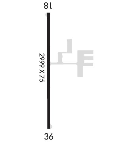
| Lat: N 3026.7 Long: W 08959.3 Elev: 38 Var: -02 Longest Runway: 3004 | ||
| CTAF: 122.8 | ||
| ||||||
|
| Rwy | Rwy | |||||||
| 3004x75 | 3004' | 3004x75 | 3004' | |||||
| Runway ID | Single Wheel | Double Wheel | Double Tandem Wheel | Dual Double Wheel |
| 18/36 | 17,500 | N/A | N/A | N/A |
| These numbers are Advisory and are not limits. The Airport Manager should have more accurate Weight Limits | ||||
| FltPlan does not have IFR approach charts available for KL31. |
 Airport Diagram might not be current. | |
| Facility Name: | ST TAMMANY RGNL |
| City Name: | COVINGTON |
| County: | ST TAMMANY |
| State abbrev: | LA |
| State Name: | LOUISIANA |
| Ownership: | PUBLICLY OWNED |
| Use: | OPEN TO THE PUBLIC |
| Owner's Name: | ST TAMMANY PARISH |
| Address: | PO BOX 628 |
| COVINGTON, LA 70434 | |
| Owner's Phone: | 985-898-2362 |
| Manager's Name: | JIM FORD |
| Address: | PO BOX 628 |
| COVINGTON, LA 70434 | |
| Phone: | (985) 898-2792 |
| FAA Region: | SOUTHWEST |
| FAA Field Office: | LNM |
| Date | Sunrise | Sunset |
|---|---|---|
| 06/08/26 Monday | 5:57 | 20:01 |
| 06/09/26 Tuesday | 5:57 | 20:01 |
| 06/10/26 Wednesday | 5:57 | 20:02 |
| 06/11/26 Thursday | 5:57 | 20:02 |
| 06/12/26 Friday | 5:57 | 20:02 |
| 06/13/26 Saturday | 5:57 | 20:03 |
| 06/14/26 Sunday | 5:57 | 20:03 |
| 06/15/26 Monday | 5:57 | 20:04 |
| 06/16/26 Tuesday | 5:57 | 20:04 |
| 06/17/26 Wednesday | 5:58 | 20:04 |
| 06/18/26 Thursday | 5:58 | 20:04 |
| 06/19/26 Friday | 5:58 | 20:05 |
| 06/20/26 Saturday | 5:58 | 20:05 |
| 06/21/26 Sunday | 5:58 | 20:05 |
| Airport Attendance Schedule | MON-FRI 0800-1500 |
| Airport Status | OPERATIONAL (This Status can change at any time - please check NOTAMS) |
| Airport Lighting Schedule | DUSK-DAWN. MIRL RY 18/36 PRESET MED INTST. |
| Airport Storage Available | Tie Downs, Hanger |
| Extra Services Available | Charter, Flight Instruction, Parachute Jumping, Aircraft Rental, Glider Towing |
| Wind Indicator | YES - (lighted) |
| Control Tower | NO |
| CTAF Frequency | 122.800 |
| Unicom Frequency | 122.800 |
| Rotating Beacon Color | WG |
| Segmented Circle | NO |
| Landing Fee | NO |
| Airport Inspected | STATE - performed by STATE AERONAUTICAL PERSONNEL |
| Inspection Date | 02/15/2024 |
| Type of Fuel Available | Grade 100LL; -10SELF SERVICE FUEL AVBL 24 HRS WITH CREDIT CARD. |
| Airframe Repair Service | MINOR |
| Power Plant Repair Service | MINOR |
| Latitude | N3026.7 |
| Longitude | W08959.3 (ESTIMATED) |
| Arpt Elevation | 37ft (SURVEYED) |
| Magnetic Variation | 02E |
| 6 miles SE | of COVINGTON |
| Traffic Pattern Altitude | |
| Sectional Chart | NEW ORLEANS |
| Operations (Reported) | Yearly | Avg. Daily |
|---|---|---|
| General Aviation Transient | 0 | 0 |
| General Aviation Local | 0 | 0 |
| Air Taxi | 0 | 0 |
| Commerical | 0 | 0 |
| Commuter | 0 | 0 |
| Military | 0 | 0 |
| Aircraft based on Field | |
|---|---|
| General Aviation Singles | 0 |
| General Aviation Multi | 0 |
| Jet Aircraft | 0 |
| General Aviation Helicopters | 0 |
| Military Aircraft | 0 |
| Gliders | 0 |
| Ultralights | 0 |
| FSS on field | NO |
| FSS tie-in | DE RIDDER |
| FSS Phone | 1-800-WX-BRIEF |
| Who issues Notams | DRI |
| Notam D service at airport | YES |
| ARTCC Name | HOUSTON |
| Airport Certification | |
| Aircraft Rescue & Firefighting Index | None |
| Airport of Entry | No |
| Custom Landing Rights | No |
| Joint Civil/Military | No |
| Military Landing rights | No |
| NATIONAL PLAN OF INTEGRATED AIRPORT SYSTEMS (NPIAS) |
| FOR CD CTC NEW ORLEANS APCH AT 504-471-4350. |
| PAJA AND SKYDIVING ACT ON WKENDS. |
| CTC APRT MGR FOR DSGND RAMP SPACE FOR PUB USE. |
Airport Communications & Frequencies:
| ||||||||||||||
| Runway: 18 | Runway: 36 | ||
| Mag heading: | 178° | Mag heading: | 358° |
| Rwy Slope: | -.03% Down | Rwy Slope: | .03% Up |
| Approach: | Approach: | ||
| Pattern: | Left Traffic | Pattern: | Left Traffic |
| Markings: | NONPRECISION INSTRUMENT | Markings: | NONPRECISION INSTRUMENT |
| Marking Condition: | GOOD | Marking Condition: | GOOD |
| Arresting Dev: | Arresting Dev: | ||
| Lat & Long: | N3027.0 W08959.3 | Lat. & Long.: | N3026.5 W08959.3 |
| Elev: | 37.6 ft. MSL | Elev: | 36.6 ft. MSL |
| TCH: | TCH: | ||
| Visual Glide Path: | Visual Glide Path: | ||
| Displaced Threshold: | No | Displaced Threshold: | No |
| Touchdown Zone: | YES | Touchdown Zone: | YES |
| Touchdown Elev.: | 37.7 feet | Touchdown Elev.: | 37.7 feet |
| Visual Glide Slope: | Visual Glide Slope: | ||
| RVR Equipment: | RVR Equipment: | ||
| RVV Equipment: | NO | RVV Equipment: | NO |
| Approach Lights: | Approach Lights: | ||
| REIL: | NO | REIL: | NO |
| Centerline Lights: | NO | Centerline Lights: | NO |
| Touchdown lights: | NO | Touchdown lights: | NO |
| Runway Category: | Runway with a Visual Approach | Runway Category: | Runway with a Visual Approach |
| Declared Distances: | Declared Distances: | ||
| Obstructions: | TREES | Obstructions: | TREES |
| Marked: | NOT Marked/Lighted | Marked: | NOT Marked/Lighted |
| Clearance slope: | 23:1 | Clearance slope: | 8:1 |
| Obstruction height: | 72 feet AGL | Obstruction height: | 88 feet AGL |
| Dist. from runway: | 1891 feet | Dist. from runway: | 905 feet |
| Centerline offset: | Centerline offset: | 180 feet left of centerline | |
| Comments: | Comments: |
Thanks for using FltPlan.com
all rights reserved © 1999-2026 by Flight Plan LLC
