
| TAFT-KERN COUNTY TAFT CA |
| |
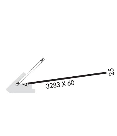
| Lat: N 3508.5 Long: W 11926.3 Elev: 858 Var: -14 Longest Runway: 3283 | ||
| CTAF: 122.8 | ||
| ||||||
|
| Rwy | Rwy | |||||||
| 3283x60 | 3283' | 3283x60 | 3283' | |||||
| Runway ID | Single Wheel | Double Wheel | Double Tandem Wheel | Dual Double Wheel |
| 07/25 | 4,000 | N/A | N/A | N/A |
| These numbers are Advisory and are not limits. The Airport Manager should have more accurate Weight Limits | ||||
| FltPlan does not have IFR approach charts available for KL17. |
 Airport Diagram might not be current. | |
| Facility Name: | TAFT-KERN COUNTY |
| City Name: | TAFT |
| County: | KERN |
| State abbrev: | CA |
| State Name: | CALIFORNIA |
| Ownership: | PUBLICLY OWNED |
| Use: | OPEN TO THE PUBLIC |
| Owner's Name: | COUNTY OF KERN DEPT OF AIRPORTS |
| Address: | 3701 WINGS WAY, SUITE 300 |
| BAKERSFIELD, CA 93308-7026 | |
| Owner's Phone: | 661-391-1800 |
| Manager's Name: | BILL LAMANQUE; DIRECTOR, KERN COUNTY AIRPORTS |
| Address: | 3701 WINGS WAY, SUITE 300 |
| BAKERSFIELD, CA 93308-7026 | |
| Phone: | (661) 391-1824; 24 HR EMERG PHONE 661-747-4055. |
| FAA Region: | WESTERN-PACIFIC |
| FAA Field Office: | LAX |
| Date | Sunrise | Sunset |
|---|---|---|
| 06/07/26 Sunday | 5:43 | 20:10 |
| 06/08/26 Monday | 5:43 | 20:11 |
| 06/09/26 Tuesday | 5:43 | 20:11 |
| 06/10/26 Wednesday | 5:43 | 20:12 |
| 06/11/26 Thursday | 5:43 | 20:12 |
| 06/12/26 Friday | 5:43 | 20:12 |
| 06/13/26 Saturday | 5:43 | 20:13 |
| 06/14/26 Sunday | 5:43 | 20:13 |
| 06/15/26 Monday | 5:43 | 20:14 |
| 06/16/26 Tuesday | 5:43 | 20:14 |
| 06/17/26 Wednesday | 5:43 | 20:14 |
| 06/18/26 Thursday | 5:43 | 20:15 |
| 06/19/26 Friday | 5:43 | 20:15 |
| 06/20/26 Saturday | 5:43 | 20:15 |
| Airport Attendance Schedule | SAT-SUN 1000-1600, MON-FRI 0800-1600 |
| Airport Status | OPERATIONAL (This Status can change at any time - please check NOTAMS) |
| Airport Lighting Schedule | MIRL RY 07/25 AND PAPI RY 25 NIGHT USE ONLY ACTVT- CTAF. |
| Airport Storage Available | Tie Downs |
| Extra Services Available | Flight Instruction, Aircraft Rental |
| Wind Indicator | YES - (lighted) |
| Control Tower | NO |
| CTAF Frequency | 122.800 |
| Unicom Frequency | 122.800 |
| Rotating Beacon Color | WG |
| Segmented Circle | YES |
| Landing Fee | NO |
| Airport Inspected | STATE - performed by STATE AERONAUTICAL PERSONNEL |
| Inspection Date | 03/05/2026 |
| Type of Fuel Available | Grade 100LL, JET A (freeze point -40C); -10SELF SERVICE ONLY. |
| Airframe Repair Service | MINOR |
| Power Plant Repair Service | MINOR |
| Latitude | N3508.5 |
| Longitude | W11926.3 (ESTIMATED) |
| Arpt Elevation | 858ft (SURVEYED) |
| Magnetic Variation | 14E |
| 1 miles E | of TAFT |
| Traffic Pattern Altitude | 800 |
| Sectional Chart | LOS ANGELES |
| Operations (Reported) | Yearly | Avg. Daily |
|---|---|---|
| General Aviation Transient | 0 | 0 |
| General Aviation Local | 0 | 0 |
| Air Taxi | 0 | 0 |
| Commerical | 0 | 0 |
| Commuter | 0 | 0 |
| Military | 0 | 0 |
| Aircraft based on Field | |
|---|---|
| General Aviation Singles | 0 |
| General Aviation Multi | 0 |
| Jet Aircraft | 0 |
| General Aviation Helicopters | 0 |
| Military Aircraft | 0 |
| Gliders | 0 |
| Ultralights | 0 |
| FSS on field | NO |
| FSS tie-in | RANCHO MURIETA |
| FSS Phone | 1-800-WX-BRIEF |
| Who issues Notams | RIU |
| Notam D service at airport | YES |
| ARTCC Name | LOS ANGELES |
| Airport Certification | |
| Aircraft Rescue & Firefighting Index | None |
| Airport of Entry | No |
| Custom Landing Rights | No |
| Joint Civil/Military | No |
| Military Landing rights | No |
| NATIONAL PLAN OF INTEGRATED AIRPORT SYSTEMS (NPIAS) |
| RY 25 STEEP UPHILL GRADE (2.2%). |
| RY 07/25 HAS A DRY STREAMBED NE END. |
| RY 07 NO TKOF WITH TAILWINDS. |
| NO STUDENT SOLO FLIGHTS PERMITTED. |
| FOR ARPT INFORMATION CALL (661) 393-7990. |
| FOR CD CTC LOS ANGELES ARTCC AT 661-575-2079. |
| Runway: 07 | Runway: 25 | ||
| Mag heading: | 66° | Mag heading: | 246° |
| Rwy Slope: | -3.02% Down | Rwy Slope: | 3.02% Up |
| Approach: | Approach: | ||
| Pattern: | Left Traffic | Pattern: | Left Traffic |
| Markings: | NONSTANDARD | Markings: | BASIC |
| Marking Condition: | FAIR; MKD WITH X'S NO LDGS TKOF ONLY. | Marking Condition: | FAIR |
| Arresting Dev: | Arresting Dev: | ||
| Lat & Long: | N3508.5 W11926.6 | Lat. & Long.: | N3508.5 W11925.9 |
| Elev: | 858.2 ft. MSL | Elev: | 759.2 ft. MSL |
| TCH: | TCH: | 57 ft. AGL | |
| Visual Glide Path: | Visual Glide Path: | 3.50 degrees | |
| Displaced Threshold: | No | Displaced Threshold: | No |
| Touchdown Zone: | YES | Touchdown Zone: | YES |
| Touchdown Elev.: | 858.2 feet | Touchdown Elev.: | 848.5 feet |
| Visual Glide Slope: | Visual Glide Slope: | 2-Light PAPI on LEFT side of Runway | |
| RVR Equipment: | RVR Equipment: | ||
| RVV Equipment: | NO | RVV Equipment: | NO |
| Approach Lights: | Approach Lights: | ||
| REIL: | NO | REIL: | NO |
| Centerline Lights: | NO | Centerline Lights: | NO |
| Touchdown lights: | NO | Touchdown lights: | NO |
| Runway Category: | Runway with a Visual Approach | Runway Category: | Runway with a Visual Approach |
| Declared Distances: | Declared Distances: | ||
| Obstructions: | POLE | Obstructions: | |
| Marked: | NOT Marked/Lighted | Marked: | |
| Clearance slope: | 7:1 | Clearance slope: | 50:1 |
| Obstruction height: | 25 feet AGL | Obstruction height: | |
| Dist. from runway: | 385 feet | Dist. from runway: | |
| Centerline offset: | 100 left of centerline | Centerline offset: | |
| Comments: | Comments: | RY 25 +4 FT BRUSH 150 FT FM EOR 50 FT RIGHT. |
Thanks for using FltPlan.com
all rights reserved © 1999-2026 by Flight Plan LLC
