
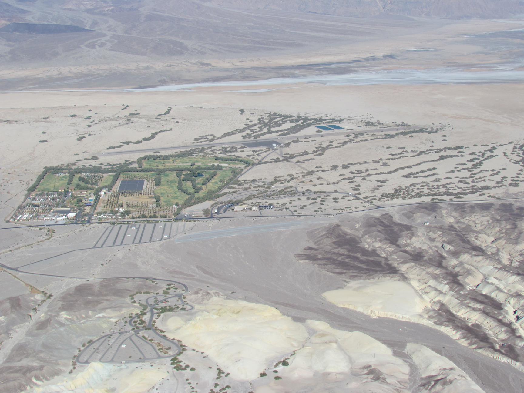
| FURNACE CREEK DEATH VALLEY NATL PK CA |
| |
| Lat: N 3627.6 Long: W 11652.8 Elev: -210 Var: -14 Longest Runway: 3065 | ||
| CTAF: 122.9 | ||
| ||||||||||||||||||||||||||||||||
| ||||||||||||||||||||||||||||||||
| Rwy | Rwy | |||||||
| 3065x70 | 3065' | 3065x70 | 3065' | |||||
| Runway ID | Single Wheel | Double Wheel | Double Tandem Wheel | Dual Double Wheel |
| 15/33 | 4,000 | N/A | N/A | N/A |
| These numbers are Advisory and are not limits. The Airport Manager should have more accurate Weight Limits | ||||
| FltPlan does not have IFR approach charts available for KL06. |
| Facility Name: | FURNACE CREEK |
| City Name: | DEATH VALLEY NATIONAL PARK |
| County: | INYO |
| State abbrev: | CA |
| State Name: | CALIFORNIA |
| Ownership: | PUBLICLY OWNED |
| Use: | OPEN TO THE PUBLIC |
| Owner's Name: | US DEPT OF INTERIOR/PARK SVC |
| Address: | DEATH VALLEY NATL PARK |
| DEATH VALLEY, CA 92328 | |
| Owner's Phone: | (760) 786-3292 |
| Manager's Name: | KEVIN ROSS |
| Address: | DEATH VALLEY NATL PARK |
| DEATH VALLEY, CA 92328 | |
| Phone: | (760) 786-3292; AIRPORT MANAGER IS A LAW ENFORCEMENT PARK RANGER, FOR EMERGENCIES CAN BE REACHED THROUGH PARK DISPATCH 760-786-2330 |
| FAA Region: | WESTERN-PACIFIC |
| FAA Field Office: | LAX |
| Date | Sunrise | Sunset |
|---|---|---|
| 09/24/21 Friday | 6:37 | 18:42 |
| 09/25/21 Saturday | 6:38 | 18:40 |
| 09/26/21 Sunday | 6:38 | 18:39 |
| 09/27/21 Monday | 6:39 | 18:37 |
| 09/28/21 Tuesday | 6:40 | 18:36 |
| 09/29/21 Wednesday | 6:41 | 18:34 |
| 09/30/21 Thursday | 6:42 | 18:33 |
| 10/01/21 Friday | 6:43 | 18:31 |
| 10/02/21 Saturday | 6:43 | 18:30 |
| 10/03/21 Sunday | 6:44 | 18:28 |
| 10/04/21 Monday | 6:45 | 18:27 |
| 10/05/21 Tuesday | 6:46 | 18:25 |
| 10/06/21 Wednesday | 6:47 | 18:24 |
| 10/07/21 Thursday | 6:48 | 18:23 |
| Airport Attendance Schedule | UNATTENDED |
| Airport Status | OPERATIONAL (This Status can change at any time - please check NOTAMS) |
| Airport Lighting Schedule | |
| Airport Storage Available | Tie Downs |
| Extra Services Available | NONE |
| Wind Indicator | YES - (lighted) |
| Control Tower | NO |
| CTAF Frequency | 122.900 |
| Unicom Frequency | |
| Rotating Beacon Color | |
| Segmented Circle | YES |
| Landing Fee | NO |
| Airport Inspected | STATE - performed by STATE AERONAUTICAL PERSONNEL |
| Inspection Date | 02/21/2020 |
| Type of Fuel Available | None |
| Airframe Repair Service | NONE |
| Power Plant Repair Service | NONE |
| Latitude | N3627.6 |
| Longitude | W11652.8 (ESTIMATED) |
| Arpt Elevation | -210ft (ESTIMATED) |
| Magnetic Variation | 14E |
| 0 miles N; ARPT LCTD 1 SM SW OF PARK HEADQUARTERS. | of DEATH VALLEY NATIONAL PARK |
| Traffic Pattern Altitude | |
| Sectional Chart | LAS VEGAS |
| Operations (Reported) | Yearly | Avg. Daily |
|---|---|---|
| General Aviation Transient | 10000 | 27 |
| General Aviation Local | 0 | 0 |
| Air Taxi | 0 | 0 |
| Commerical | 0 | 0 |
| Commuter | 0 | 0 |
| Military | 500 | 1 |
| Aircraft based on Field | |
|---|---|
| General Aviation Singles | 3 |
| General Aviation Multi | 0 |
| Jet Aircraft | 0 |
| General Aviation Helicopters | 0 |
| Military Aircraft | 0 |
| Gliders | 0 |
| Ultralights | 0 |
| FSS on field | NO |
| FSS tie-in | RIVERSIDE |
| FSS Phone | 1-800-WX-BRIEF |
| Who issues Notams | RAL |
| Notam D service at airport | YES |
| ARTCC Name | LOS ANGELES |
| Airport Certification | |
| Aircraft Rescue & Firefighting Index | None |
| Airport of Entry | No |
| Custom Landing Rights | No |
| Joint Civil/Military | No |
| Military Landing rights | No |
| USE ONLY MKD RY FOR GROUND OPNS. SAFETY AREA ROUGH & SOFT. |
| NO TIEDOWN ROPES OR CHAINS AVBL. |
| DITCH 145 FT RIGHT OF RY 33. |
| SAFETY AREAS ADJ RY CLSD, STAY ON PAVED AREA ONLY DUE TO EXTREMELY SOFT DIRT. |
| ARPT CLSD TO NIGHT OPS. |
| FOR CD IF UNA TO CTC ON FSS FREQ, CTC LOS ANGELES ARTCC AT 661-575-2079. |
| RWY 15/33 PAVEMENT HEAVING, EXTREMELY ROUGH SFC. POTENTIAL FOR DMG TO ACFT USING THIS RWY. |
| RWY 15/3 3 UP TO 4 INCH SALT HEAVE ARND RWY CRACKS. COULD DMG ACFT WITH WHEEL FAIRINGS OR CAUSE A POTENTIAL TO BLOW OUT A TIRE. |
| Runway: 15 | Runway: 33 | ||
| Mag heading: | N/A | Mag heading: | N/A |
| Approach: | Approach: | ||
| Pattern: | Right Traffic | Pattern: | Left Traffic |
| Markings: | BASIC | Markings: | BASIC |
| Marking Condition: | FAIR | Marking Condition: | FAIR |
| Arresting Dev: | Arresting Dev: | ||
| Lat & Long: | N3627.9 W11652.9 | Lat. & Long.: | N3627.4 W11652.7 |
| Elev: | N/A | Elev: | N/A |
| TCH: | TCH: | ||
| Visual Glide Path: | Visual Glide Path: | ||
| Displaced Threshold: | No | Displaced Threshold: | No |
| Touchdown Zone: | NO | Touchdown Zone: | NO |
| Touchdown Elev.: | Touchdown Elev.: | ||
| Visual Glide Slope: | Visual Glide Slope: | ||
| RVR Equipment: | RVR Equipment: | ||
| RVV Equipment: | NO | RVV Equipment: | NO |
| Approach Lights: | Approach Lights: | ||
| REIL: | NO | REIL: | NO |
| Centerline Lights: | NO | Centerline Lights: | NO |
| Touchdown lights: | NO | Touchdown lights: | NO |
| Runway Category: | Runway with a Visual Approach | Runway Category: | Runway with a Visual Approach |
| Declared Distances: | Declared Distances: | ||
| Obstructions: | BRUSH | Obstructions: | BRUSH |
| Marked: | NOT Marked/Lighted | Marked: | NOT Marked/Lighted |
| Clearance slope: | Clearance slope: | 20:1 | |
| Obstruction height: | 15 feet AGL | Obstruction height: | 15 feet AGL |
| Dist. from runway: | 210 feet | Dist. from runway: | 500 feet |
| Centerline offset: | 100 left of centerline | Centerline offset: | 130 feet left of centerline |
| Comments: | Comments: |
Thanks for using FltPlan.com
all rights reserved © 1999-2021 by Flight Plan LLC