
| HOLTVILLE HOLTVILLE CA |
| |
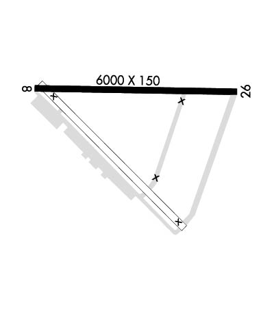
| Lat: N 3250.7 Long: W 11516.1 Elev: 59 Var: -13 Longest Runway: 6000 | ||
| CTAF: 123.0 | ||
| ||||||||||||||||||||||||||||||||
| ||||||||||||||||||||||||||||||||
| Rwy | Rwy | |||||||
| 6000x150 | 6000' | 6000x150 | 6000' | |||||
| Runway ID | Single Wheel | Double Wheel | Double Tandem Wheel | Dual Double Wheel |
| 08/26 | 30,000 | 50,000 | N/A | N/A |
| These numbers are Advisory and are not limits. The Airport Manager should have more accurate Weight Limits | ||||
| FltPlan does not have IFR approach charts available for KL04. |
 Airport Diagram might not be current. | |
| Facility Name: | HOLTVILLE |
| City Name: | HOLTVILLE |
| County: | IMPERIAL |
| State abbrev: | CA |
| State Name: | CALIFORNIA |
| Ownership: | PUBLICLY OWNED |
| Use: | OPEN TO THE PUBLIC |
| Owner's Name: | COUNTY OF IMPERIAL |
| Address: | 940 W. MAIN ST |
| EL CENTRO, CA 92243 | |
| Owner's Phone: | (442) 265-1001 |
| Manager's Name: | SANDY CARVER |
| Address: | 940 W. MAIN STREET, SUITE 208 |
| EL CENTRO, CA 95543 | |
| Phone: | (442) 265-3220X5; ARPT MANAGERS OFFICE AT IMPERIAL CO. ARPT. |
| FAA Region: | WESTERN-PACIFIC |
| FAA Field Office: | LAX |
| Date | Sunrise | Sunset |
|---|---|---|
| 09/24/21 Friday | 6:30 | 18:35 |
| 09/25/21 Saturday | 6:31 | 18:34 |
| 09/26/21 Sunday | 6:32 | 18:33 |
| 09/27/21 Monday | 6:32 | 18:31 |
| 09/28/21 Tuesday | 6:33 | 18:30 |
| 09/29/21 Wednesday | 6:34 | 18:29 |
| 09/30/21 Thursday | 6:34 | 18:27 |
| 10/01/21 Friday | 6:35 | 18:26 |
| 10/02/21 Saturday | 6:36 | 18:25 |
| 10/03/21 Sunday | 6:36 | 18:23 |
| 10/04/21 Monday | 6:37 | 18:22 |
| 10/05/21 Tuesday | 6:38 | 18:21 |
| 10/06/21 Wednesday | 6:39 | 18:19 |
| 10/07/21 Thursday | 6:39 | 18:18 |
| Airport Attendance Schedule | UNATTENDED |
| Airport Status | CLOSED INDEFINITELY (This Status can change at any time - please check NOTAMS) |
| Airport Lighting Schedule | |
| Airport Storage Available | NONE |
| Extra Services Available | NONE |
| Wind Indicator | NONE |
| Control Tower | NO |
| CTAF Frequency | 123.000 |
| Unicom Frequency | 123.000 |
| Rotating Beacon Color | |
| Segmented Circle | NO |
| Landing Fee | NO |
| Airport Inspected | STATE - performed by STATE AERONAUTICAL PERSONNEL |
| Inspection Date | 01/30/2017 |
| Type of Fuel Available | None |
| Airframe Repair Service | NONE |
| Power Plant Repair Service | NONE |
| Latitude | N3250.7 |
| Longitude | W11516.1 (ESTIMATED) |
| Arpt Elevation | 59ft (SURVEYED) |
| Magnetic Variation | 13E |
| 5 miles NE | of HOLTVILLE |
| Traffic Pattern Altitude | 800 |
| Sectional Chart | PHOENIX |
| Operations (Reported) | Yearly | Avg. Daily |
|---|---|---|
| General Aviation Transient | 0 | 0 |
| General Aviation Local | 0 | 0 |
| Air Taxi | 0 | 0 |
| Commerical | 0 | 0 |
| Commuter | 0 | 0 |
| Military | 0 | 0 |
| Aircraft based on Field | |
|---|---|
| General Aviation Singles | 0 |
| General Aviation Multi | 0 |
| Jet Aircraft | 0 |
| General Aviation Helicopters | 0 |
| Military Aircraft | 0 |
| Gliders | 0 |
| Ultralights | 0 |
| FSS on field | NO |
| FSS tie-in | SAN DIEGO |
| FSS Phone | 1-800-WX-BRIEF |
| Who issues Notams | SAN |
| Notam D service at airport | YES |
| ARTCC Name | LOS ANGELES |
| Airport Certification | |
| Aircraft Rescue & Firefighting Index | None |
| Airport of Entry | No |
| Custom Landing Rights | No |
| Joint Civil/Military | No |
| Military Landing rights | YES |
| SURPLUS PROPERTY AGREEMENT UNDER PUBLIC LAW 289 |
| BE ALERT FREQUENT MILITARY TRAINING ACTIVITY DURING DALGT HRS AND DARK; INCLUDES TACTICAL ACFT; HELICOPTERS AND PARACHUTING; CHECK LOCAL NOTAMS CALL 619-337-7792. |
| FOR CD CTC LOS ANGELES ARTCC AT 661-575-2079. |
| (ARPT STATUS) ARPT CLSD INDEFLY. |
| RWY 08/2 6 1-2 FT HOLES IN PAVEMENT, BUCKLED SECTION SLABS UP TO 5 FT. |
| RWY 08/2 6 LIMITED BY AMGR TO 20000 LBS; SINGLE WHEEL GEAR. |
| RWY 08/2 6 LIMITED BY AMGR TO 40000 LBS; DUAL TANDEM WHEEL GEAR. |
| Runway: 08 | Runway: 26 | ||
| Mag heading: | N/A | Mag heading: | N/A |
| Approach: | Approach: | ||
| Pattern: | Left Traffic | Pattern: | Left Traffic |
| Markings: | Markings: | ||
| Marking Condition: | Marking Condition: | ||
| Arresting Dev: | Arresting Dev: | ||
| Lat & Long: | N3250.7 W11516.7 | Lat. & Long.: | N3250.7 W11515.5 |
| Elev: | N/A | Elev: | N/A |
| TCH: | TCH: | ||
| Visual Glide Path: | Visual Glide Path: | ||
| Displaced Threshold: | No | Displaced Threshold: | No |
| Touchdown Zone: | NO | Touchdown Zone: | NO |
| Touchdown Elev.: | Touchdown Elev.: | ||
| Visual Glide Slope: | Visual Glide Slope: | ||
| RVR Equipment: | RVR Equipment: | ||
| RVV Equipment: | NO | RVV Equipment: | NO |
| Approach Lights: | Approach Lights: | ||
| REIL: | NO | REIL: | NO |
| Centerline Lights: | NO | Centerline Lights: | NO |
| Touchdown lights: | NO | Touchdown lights: | NO |
| Runway Category: | Runway Category: | ||
| Declared Distances: | Declared Distances: |
Thanks for using FltPlan.com
all rights reserved © 1999-2021 by Flight Plan LLC
