
| ALBUQUERQUE INTL SUNPORT ALBUQUERQUE NM |
| |
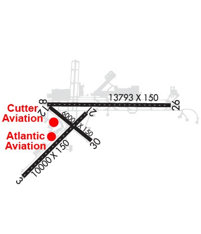
| Lat: N 3502.3 Long: W 10636.5 Elev: 5355 Var: -11 Longest Runway: 13793 | ||
| Clr Del: 119.2 Dept. ATIS: 118.0 Arr. ATIS: 118.0 Ground: 121.9 Tower: 120.3/123.77 | ||
| |||||||||||||||||||||||||||||||||||||||||||||||||||||||||||||||||||||
| |||||||||||||||||||||||||||||||||||||||||||||||||||||||||||||||||||||
| |||||||||||||||||||||||||||||||||||||||||||||||||||||||||||||||||||||
| |||||||||||||||||||||||||||||||||||||||||||||||||||||||||||||||||||||
| Rwy | Rwy | |||||||
| 10000x150 | 10000' | 111.50 - 033° | 10000x150 | 10000' | ||||
| 13793x150 | 12793' | 111.90 - 079° | 13793x150 | 13793' | ||||
| 6000x150 | 6000' | 6000x150 | 6000' | |||||
| Runway ID | Single Wheel | Double Wheel | Double Tandem Wheel | Dual Double Wheel |
| 03/21 | 100,000 | 210,000 | 360,000 | 720,000 |
| 08/26 | 100,000 | 210,000 | 360,000 | 720,000 |
| 12/30 | 65,000 | 120,000 | 155,000 | N/A |
| These numbers are Advisory and are not limits. The Airport Manager should have more accurate Weight Limits | ||||
 Airport Diagram might not be current. | |
| Facility Name: | ALBUQUERQUE INTL SUNPORT |
| City Name: | ALBUQUERQUE |
| County: | BERNALILLO |
| State abbrev: | NM |
| State Name: | NEW MEXICO |
| Ownership: | PUBLICLY OWNED |
| Use: | OPEN TO THE PUBLIC |
| Owner's Name: | CITY OF ALBUQUERQUE |
| Address: | PO BOX 1293 |
| ALBUQUERQUE, NM 87103 | |
| Owner's Phone: | 505-768-3000 |
| Manager's Name: | MANNY MANRIQUEZ; RICHARD MCCURLEY |
| Address: | PO BOX 9948 |
| ALBUQUERQUE, NM 87119 | |
| Phone: | 505-244-7700 |
| FAA Region: | SOUTHWEST |
| FAA Field Office: | LNM |
| Date | Sunrise | Sunset |
|---|---|---|
| 07/25/26 Saturday | 6:10 | 20:15 |
| 07/26/26 Sunday | 6:11 | 20:14 |
| 07/27/26 Monday | 6:12 | 20:14 |
| 07/28/26 Tuesday | 6:13 | 20:13 |
| 07/29/26 Wednesday | 6:13 | 20:12 |
| 07/30/26 Thursday | 6:14 | 20:11 |
| 07/31/26 Friday | 6:15 | 20:10 |
| 08/01/26 Saturday | 6:16 | 20:09 |
| 08/02/26 Sunday | 6:16 | 20:09 |
| 08/03/26 Monday | 6:17 | 20:08 |
| 08/04/26 Tuesday | 6:18 | 20:07 |
| 08/05/26 Wednesday | 6:19 | 20:06 |
| 08/06/26 Thursday | 6:19 | 20:05 |
| 08/07/26 Friday | 6:20 | 20:04 |
| Airport Attendance Schedule | CONTINUOUS |
| Airport Status | OPERATIONAL (This Status can change at any time - please check NOTAMS) |
| Airport Lighting Schedule | SS-SR |
| Airport Storage Available | Tie Downs, Hanger |
| Extra Services Available | Air Ambulance, Avionics, Cargo Handling, Charter, Flight Instruction, Aircraft Rental, Aircraft Sales, Annual Surveying |
| Wind Indicator | YES - (lighted) |
| Control Tower | YES |
| CTAF Frequency | |
| Unicom Frequency | 122.950 |
| Rotating Beacon Color | WG |
| Segmented Circle | NO |
| Landing Fee | NO |
| Airport Inspected | FEDERAL - performed by FAA AIRPORTS FIELD PERSONNEL |
| Inspection Date | 02/05/2026 |
| Type of Fuel Available | Grade 100LL, JET A (freeze point -40C), JET A-1 (freeze point -50C), JET A-1 (icing inhibitor, freeze point -50C) |
| Airframe Repair Service | MAJOR |
| Power Plant Repair Service | MAJOR |
| Latitude | N3502.3 |
| Longitude | W10636.5 (ESTIMATED) |
| Arpt Elevation | 5354ft (SURVEYED) |
| Magnetic Variation | 11E |
| 3 miles SE | of ALBUQUERQUE |
| Traffic Pattern Altitude | |
| Sectional Chart | ALBUQUERQUE |
| Operations (Reported) | Yearly | Avg. Daily |
|---|---|---|
| General Aviation Transient | 0 | 0 |
| General Aviation Local | 0 | 0 |
| Air Taxi | 0 | 0 |
| Commerical | 0 | 0 |
| Commuter | 0 | 0 |
| Military | 0 | 0 |
| Aircraft based on Field | |
|---|---|
| General Aviation Singles | 0 |
| General Aviation Multi | 0 |
| Jet Aircraft | 0 |
| General Aviation Helicopters | 0 |
| Military Aircraft | 0 |
| Gliders | 0 |
| Ultralights | 0 |
| FSS on field | NO |
| FSS tie-in | ALBUQUERQUE |
| FSS Phone | 1-800-WX-BRIEF |
| Who issues Notams | ABQ |
| Notam D service at airport | YES |
| ARTCC Name | ALBUQUERQUE |
| Airport Certification | AIRPORT RECEIVING SCHEDULED AIR CARRIER SERVICE FROM CARRIERS CERTIFICATED BY THE CIVIL AERONAUTICS BOARD |
| Aircraft Rescue & Firefighting Index | AIRPORT HAS A CERTIFICATE UNDER CFR PART 139 |
| Airport of Entry | No |
| Custom Landing Rights | YES |
| Joint Civil/Military | No |
| Military Landing rights | YES |
| NATIONAL PLAN OF INTEGRATED AIRPORT SYSTEMS (NPIAS) |
| GRANT AGREEMENTS UNDER FAAP/ADAP/AIP |
| SURPLUS PROPERTY AGREEMENT UNDER PUBLIC LAW 289 |
| CONVEYANCE UNDER SCETION 16, FEDERAL AIRPORT ACT OF 1946 OR SECTION 23, AIRPORT AND AIRWAY DEVELOPMENT ACT OF 1970 |
| ASSURANCES PURSUANT TO TITLE VI, CIVIL RIGHTS ACT OF 1964 |
| ACR GND HANDLING NA 0100-0430. |
| BIRD HAZ OCT-DEC & MAR-MAY; STUDENT HEL TFC. |
| TWY H MIL USE ONLY. |
| FIGHTER ACFT DEP S ONLY. |
| TWY E5 CLSD. |
| SVC: MIL FUEL A++; A++ 100. |
| MIL WX SVC AVBL 1300-0600Z++ MON-FRI; CLSD WKEND, HOL & DOWN DAYS. AFT HR MSN WX SUPPORT BRIEFINGS - 25 OWS/DAVIS-MONTHAN AFB D228-6604/C520-228-6604. NWS KABQ FCST - D246-9707/C505-846-9707. FAA OBS H24 - C505-246-4200. |
| MISC: FOR TMPRY DUTY OF 2 OR MORE DAYS, OR MSN REQ SPECIAL HANDLING, CTC 377ABW/IG AT DSN 253-4376/1304 OR C505-853-4376/1304 NLT 14 DAYS PRIOR TO ANTICIPATED ARR DATE. |
| AF - MIL WX SVC AVBL 1300-0600Z++ MON-FRI. |
| AF - KIRTLAND AFB AFLD MGMNT OPR 1400-2300Z++ MON-FRI; CLSD SAT, SUN, & FED HOLS. |
| CTL FIRING AREA S. |
| ARFF PRVDD BY USAF. |
| RWY 03 DEP RSTRD; PPR - ATCT. |
| RWY 08 RWY 08 & 12 APCH END DECOUPLED; COMMON HOLD SHORT LINE SHARED. |
| RWY 12 TKOF VIA TXY E; FULL LEN AVBL VIA BACK TAX. RWY 08 & 12 APCH ENDS DECOUPLED; COMMON HOLD SHORT LINE SHARED. |
| RWY 30 LNDG: LAST AVBL EXIT TXY E; EXIT E1 NOT PSBL. |
| RWY 03/2 1 PCR VALUE: 800/R/D/W/T |
| RWY 08/2 6 PCR VALUE: 700/R/B/W/T |
| RWY 12/3 0 PCR VALUE: 460/R/D/W/T |
Airport Communications & Frequencies:
| |||||||||||||||||||||||||||||||||||||||||||||||||||||||
| Runway: 03 | Runway: 21 | ||
| Mag heading: | 34° | Mag heading: | 214° |
| Rwy Slope: | .11% Up | Rwy Slope: | -.11% Down |
| Approach: | ILS | Approach: | |
| Pattern: | Right Traffic | Pattern: | Left Traffic |
| Markings: | PRECISION INSTRUMENT | Markings: | PRECISION INSTRUMENT |
| Marking Condition: | GOOD | Marking Condition: | GOOD |
| Arresting Dev: | Arresting Dev: | ||
| Lat & Long: | N3501.3 W10637.8 | Lat. & Long.: | N3502.5 W10636.4 |
| Elev: | 5305.1 ft. MSL | Elev: | 5316.1 ft. MSL |
| TCH: | 59 ft. AGL | TCH: | 74 ft. AGL |
| Visual Glide Path: | 3.00 degrees | Visual Glide Path: | 3.00 degrees |
| Displaced Threshold: | No | Displaced Threshold: | No |
| Touchdown Zone: | YES | Touchdown Zone: | YES |
| Touchdown Elev.: | 5312.2 feet | Touchdown Elev.: | 5316.2 feet |
| Visual Glide Slope: | 4-Light PAPI on LEFT side of Runway | Visual Glide Slope: | 4-Light PAPI on LEFT side of Runway |
| RVR Equipment: | TOUCHDOWN-ROLLOUT | RVR Equipment: | TOUCHDOWN-ROLLOUT |
| RVV Equipment: | NO | RVV Equipment: | NO |
| Approach Lights: | MALSR - 1,400 foot medium intensity approach lighting system with runway alignment indicator lights | Approach Lights: | |
| REIL: | NO | REIL: | YES |
| Centerline Lights: | YES | Centerline Lights: | YES |
| Touchdown lights: | YES | Touchdown lights: | NO |
| Runway Category: | Precision Instrument Runway | Runway Category: | Runway with a Visual Approach |
| Declared Distances: | TORA:10000' TODA:10000' ASDA:9754' LDA:9754' | Declared Distances: | TORA:10000' TODA:10000' ASDA:10000' LDA:10000' |
| Runway: 08 | Runway: 26 | ||
| Mag heading: | 79° | Mag heading: | 259° |
| Rwy Slope: | .31% Up | Rwy Slope: | -.31% Down |
| Approach: | ILS/DME | Approach: | |
| Pattern: | Right Traffic | Pattern: | Left Traffic |
| Markings: | PRECISION INSTRUMENT | Markings: | PRECISION INSTRUMENT |
| Marking Condition: | GOOD | Marking Condition: | GOOD |
| Arresting Dev: | Arresting Dev: | ||
| Lat & Long: | N3502.7 W10637.3 | Lat. & Long.: | N3502.6 W10634.5 |
| Elev: | 5311.9 ft. MSL | Elev: | 5354.9 ft. MSL |
| TCH: | 55 ft. AGL | TCH: | 83 ft. AGL |
| Visual Glide Path: | 2.95 degrees | Visual Glide Path: | 3.00 degrees |
| Displaced Threshold: | 1000 feet | Displaced Threshold: | No |
| Touchdown Zone: | YES | Touchdown Zone: | YES |
| Touchdown Elev.: | 5319.9 feet | Touchdown Elev.: | 5354.9 feet |
| Visual Glide Slope: | 6-BOX VASI ON LEFT SIDE OF RUNWAY | Visual Glide Slope: | 4-Light PAPI on LEFT side of Runway; PAPI DOES NOT PRVD OBST CLNC BYD 3.5 NM FM THR; UNUSBL BYD 3.5 NM. |
| RVR Equipment: | TOUCHDOWN | RVR Equipment: | ROLLOUT |
| RVV Equipment: | NO | RVV Equipment: | NO |
| Approach Lights: | MALSR - 1,400 foot medium intensity approach lighting system with runway alignment indicator lights | Approach Lights: | |
| REIL: | NO | REIL: | YES |
| Centerline Lights: | YES | Centerline Lights: | YES |
| Touchdown lights: | YES | Touchdown lights: | NO |
| Runway Category: | Precision Instrument Runway | Runway Category: | Runway with a Visual Approach |
| Declared Distances: | TORA:13793' TODA:13793' ASDA:13793' LDA:12793' | Declared Distances: | TORA:13793' TODA:13793' ASDA:13793' LDA:13793' |
| Runway: 12 | Runway: 30 | ||
| Mag heading: | 118° | Mag heading: | 298° |
| Rwy Slope: | .02% Up | Rwy Slope: | -.02% Down |
| Approach: | Approach: | ||
| Pattern: | Right Traffic | Pattern: | Left Traffic |
| Markings: | BASIC | Markings: | BASIC |
| Marking Condition: | GOOD | Marking Condition: | GOOD |
| Arresting Dev: | Arresting Dev: | ||
| Lat & Long: | N3502.6 W10637.2 | Lat. & Long.: | N3502.0 W10636.3 |
| Elev: | 5312.4 ft. MSL | Elev: | 5313.6 ft. MSL |
| TCH: | TCH: | 46 ft. AGL | |
| Visual Glide Path: | Visual Glide Path: | 3.00 degrees | |
| Displaced Threshold: | No | Displaced Threshold: | No |
| Touchdown Zone: | YES | Touchdown Zone: | YES |
| Touchdown Elev.: | 5314.5 feet | Touchdown Elev.: | 5316.1 feet |
| Visual Glide Slope: | Visual Glide Slope: | 4-Light PAPI on LEFT side of Runway | |
| RVR Equipment: | ROLLOUT | RVR Equipment: | TOUCHDOWN |
| RVV Equipment: | NO | RVV Equipment: | NO |
| Approach Lights: | Approach Lights: | ||
| REIL: | NO | REIL: | YES |
| Centerline Lights: | NO | Centerline Lights: | NO |
| Touchdown lights: | NO | Touchdown lights: | NO |
| Runway Category: | Runway with a Visual Approach | Runway Category: | Runway with a Visual Approach |
| Declared Distances: | TORA:6000' TODA:6000' ASDA:6000' LDA:6000' | Declared Distances: | TORA:6000' TODA:6000' ASDA:6000' LDA:6000' |
Thanks for using FltPlan.com
all rights reserved © 1999-2026 by Flight Plan LLC


