| ZANESVILLE MUNI ZANESVILLE OH |
| |
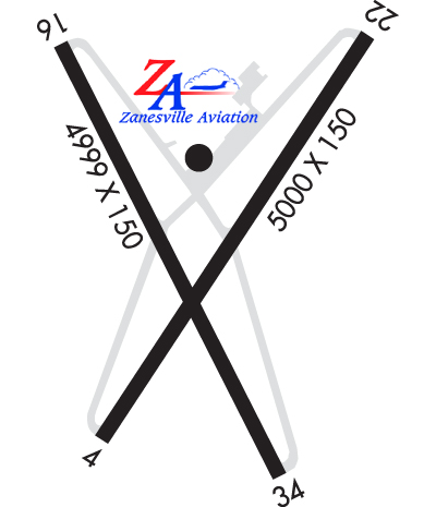
| Lat: N 3956.7 Long: W 08153.5 Elev: 900 Var: +06 Longest Runway: 4999 | ||
| AWOS: 111.4 CTAF: 123.0 | ||
| |||||||||||||||||||||||||||||||||||||||||||||||||||||||||||||||||||||
| |||||||||||||||||||||||||||||||||||||||||||||||||||||||||||||||||||||
| |||||||||||||||||||||||||||||||||||||||||||||||||||||||||||||||||||||
| Rwy | Rwy | |||||||
| 4999x150 | 4999' | 4999x150 | 4999' | 109.95 - 219° | ||||
| 4998x75 | 4798' | 4998x75 | 4798' | |||||
| Runway ID | Single Wheel | Double Wheel | Double Tandem Wheel | Dual Double Wheel |
| 04/22 | 38,000 | 50,000 | 75,000 | N/A |
| 16/34 | 38,000 | 50,000 | 75,000 | N/A |
| These numbers are Advisory and are not limits. The Airport Manager should have more accurate Weight Limits | ||||
 Airport Diagram might not be current. | |
| Facility Name: | ZANESVILLE MUNI |
| City Name: | ZANESVILLE |
| County: | MUSKINGUM |
| State abbrev: | OH |
| State Name: | OHIO |
| Ownership: | PUBLICLY OWNED |
| Use: | OPEN TO THE PUBLIC |
| Owner's Name: | CITY OF ZANESVILLE |
| Address: | 401 MARKET ST |
| ZANESVILLE, OH 43701-3520 | |
| Owner's Phone: | 740-455-0663 |
| Manager's Name: | JIM WITTE |
| Address: | 850 AIRPORT RD |
| ZANESVILLE, OH 43701-0969 | |
| Phone: | 740-452-3625 |
| FAA Region: | GREAT LAKES |
| FAA Field Office: | DET |
| Date | Sunrise | Sunset |
|---|---|---|
| 09/24/21 Friday | 7:17 | 19:22 |
| 09/25/21 Saturday | 7:18 | 19:20 |
| 09/26/21 Sunday | 7:19 | 19:18 |
| 09/27/21 Monday | 7:20 | 19:17 |
| 09/28/21 Tuesday | 7:21 | 19:15 |
| 09/29/21 Wednesday | 7:22 | 19:14 |
| 09/30/21 Thursday | 7:23 | 19:12 |
| 10/01/21 Friday | 7:24 | 19:10 |
| 10/02/21 Saturday | 7:25 | 19:09 |
| 10/03/21 Sunday | 7:26 | 19:07 |
| 10/04/21 Monday | 7:27 | 19:05 |
| 10/05/21 Tuesday | 7:28 | 19:04 |
| 10/06/21 Wednesday | 7:29 | 19:02 |
| 10/07/21 Thursday | 7:30 | 19:01 |
| Airport Attendance Schedule | MON-FRI 0800-1800, SAT-SUN 1000-1800 |
| Airport Status | OPERATIONAL (This Status can change at any time - please check NOTAMS) |
| Airport Lighting Schedule | ACTVT REIL RWY 04, 22, 16, & 34; HIRL RWY 04/22; MIRL RWY 16/34 - CTAF. PAPI RWY 04 & 22 OPR CONSLY. |
| Airport Storage Available | Tie Downs, Hanger |
| Extra Services Available | Charter |
| Wind Indicator | YES - (lighted) |
| Control Tower | NO |
| CTAF Frequency | 123.000 |
| Unicom Frequency | 123.000 |
| Rotating Beacon Color | CLEAR-GREEN (Light Land Airport) |
| Segmented Circle | NO |
| Landing Fee | NO |
| Airport Inspected | STATE - performed by PRIVATE CONTRACT PERSONNEL |
| Inspection Date | 06/30/2017 |
| Type of Fuel Available | Grade 100LL, JET A-1 (icing inhibitor, freeze point -50C) |
| Airframe Repair Service | NONE |
| Power Plant Repair Service | NONE |
| Latitude | N3956.7 |
| Longitude | W08153.5 (ESTIMATED) |
| Arpt Elevation | 899ft (SURVEYED) |
| Magnetic Variation | 06W |
| 5 miles E | of ZANESVILLE |
| Traffic Pattern Altitude | |
| Sectional Chart | CINCINNATI |
| Operations (Reported) | Yearly | Avg. Daily |
|---|---|---|
| General Aviation Transient | 6800 | 19 |
| General Aviation Local | 25000 | 68 |
| Air Taxi | 1064 | 3 |
| Commerical | 0 | 0 |
| Commuter | 0 | 0 |
| Military | 448 | 1 |
| Aircraft based on Field | |
|---|---|
| General Aviation Singles | 12 |
| General Aviation Multi | 3 |
| Jet Aircraft | 3 |
| General Aviation Helicopters | 0 |
| Military Aircraft | 0 |
| Gliders | 0 |
| Ultralights | 0 |
| FSS on field | NO |
| FSS tie-in | CLEVELAND |
| FSS Phone | 1-800-WX-BRIEF |
| Who issues Notams | ZZV |
| Notam D service at airport | YES |
| ARTCC Name | INDIANAPOLIS |
| Airport Certification | |
| Aircraft Rescue & Firefighting Index | None |
| Airport of Entry | No |
| Custom Landing Rights | No |
| Joint Civil/Military | No |
| Military Landing rights | YES |
| NATIONAL PLAN OF INTEGRATED AIRPORT SYSTEMS (NPIAS) |
| GRANT AGREEMENTS UNDER FAAP/ADAP/AIP |
| ASSURANCES PURSUANT TO TITLE VI, CIVIL RIGHTS ACT OF 1964 |
| AGREEMENT UNDER DLAND OR DCLA HAS EXPIRED. |
| DEER, BIRDS, & OTR WILDLIFE ON & INVOF ARPT. |
| RWY 04/22 & RWY 16/34 ACFT NOT VSB FM RWY ENDS. |
| TWY B LGTS U/S INDEFLY. |
| FOR CD IF UNA TO CTC ON FSS FREQ, CTC INDIANAPOLIS ARTCC AT 317-247-2411. |
Airport Communications & Frequencies:
| |||||||||
| Runway: 04 | Runway: 22 | ||
| Mag heading: | 40° | Mag heading: | 220° |
| Rwy Slope: | -.53% Down | Rwy Slope: | .53% Up |
| Approach: | Approach: | ILS/DME | |
| Pattern: | Left Traffic | Pattern: | Left Traffic |
| Markings: | NONPRECISION INSTRUMENT | Markings: | PRECISION INSTRUMENT |
| Marking Condition: | GOOD | Marking Condition: | GOOD |
| Arresting Dev: | Arresting Dev: | ||
| Lat & Long: | N3956.3 W08153.8 | Lat. & Long.: | N3957.0 W08153.2 |
| Elev: | 896.1 ft. MSL | Elev: | 869.4 ft. MSL |
| TCH: | 35 ft. AGL | TCH: | 47 ft. AGL |
| Visual Glide Path: | 3.00 degrees | Visual Glide Path: | 3.00 degrees |
| Displaced Threshold: | No | Displaced Threshold: | No |
| Touchdown Zone: | YES | Touchdown Zone: | YES |
| Touchdown Elev.: | 899.8 feet | Touchdown Elev.: | 891.7 feet |
| Visual Glide Slope: | 4-Light PAPI on RIGHT side of Runway; UNUSBL BYD 4 DEGS R OF CL. | Visual Glide Slope: | 4-Light PAPI on LEFT side of Runway |
| RVR Equipment: | RVR Equipment: | ||
| RVV Equipment: | NO | RVV Equipment: | NO |
| Approach Lights: | Approach Lights: | ||
| REIL: | YES | REIL: | YES |
| Centerline Lights: | NO | Centerline Lights: | NO |
| Touchdown lights: | NO | Touchdown lights: | NO |
| Runway Category: | Runway with a Non-precision Approach having visibility minimums greater than 3/4 mile | Runway Category: | Precision Instrument Runway |
| Declared Distances: | Declared Distances: | ||
| Comments: | +2-5 FT BRUSH, 0-95 FT DIST, 180-250 FT R. | Comments: |
| Runway: 16 | Runway: 34 | ||
| Mag heading: | 158° | Mag heading: | 338° |
| Rwy Slope: | .57% Up | Rwy Slope: | -.57% Down |
| Approach: | Approach: | ||
| Pattern: | Left Traffic | Pattern: | Left Traffic |
| Markings: | NONPRECISION INSTRUMENT | Markings: | NONPRECISION INSTRUMENT |
| Marking Condition: | GOOD | Marking Condition: | GOOD |
| Arresting Dev: | Arresting Dev: | ||
| Lat & Long: | N3957.0 W08153.8 | Lat. & Long.: | N3956.3 W08153.4 |
| Elev: | 866.7 ft. MSL | Elev: | 895.4 ft. MSL |
| TCH: | TCH: | ||
| Visual Glide Path: | Visual Glide Path: | ||
| Displaced Threshold: | 200 feet | Displaced Threshold: | 200 feet |
| Touchdown Zone: | YES | Touchdown Zone: | YES |
| Touchdown Elev.: | 895.3 feet | Touchdown Elev.: | 897.4 feet |
| Visual Glide Slope: | Visual Glide Slope: | 4-Light PAPI on LEFT side of Runway; U/S. | |
| RVR Equipment: | RVR Equipment: | ||
| RVV Equipment: | NO | RVV Equipment: | NO |
| Approach Lights: | Approach Lights: | ||
| REIL: | YES | REIL: | YES |
| Centerline Lights: | NO | Centerline Lights: | NO |
| Touchdown lights: | NO | Touchdown lights: | NO |
| Runway Category: | Runway with a Visual Approach | Runway Category: | Runway with a Visual Approach |
| Declared Distances: | TORA:4998' TODA:4998' ASDA:4798' LDA:4598' | Declared Distances: | TORA:4998' TODA:4998' ASDA:4798' LDA:4598' |
| Obstructions: | TREES | Obstructions: | TREES |
| Marked: | NOT Marked/Lighted | Marked: | NOT Marked/Lighted |
| Clearance slope: | 24:1 | Clearance slope: | 7:1 |
| Obstruction height: | 70 feet AGL | Obstruction height: | 10 feet AGL |
| Dist. from runway: | 1880 feet | Dist. from runway: | 275 feet |
| Centerline offset: | Centerline offset: | 105 feet left of centerline | |
| Comments: | Comments: |
Thanks for using FltPlan.com
all rights reserved © 1999-2021 by Flight Plan LLC