
| VIROQUA MUNI VIROQUA WI |
| |
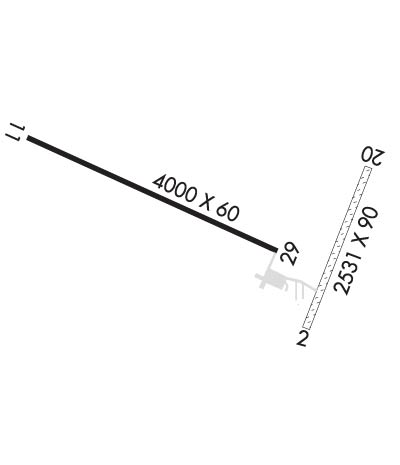
| Lat: N 4334.8 Long: W 09053.9 Elev: 1292 Var: -00 Longest Runway: 4000 | ||
| AWOS: 118.97 CTAF: 122.9 | ||
| ||||||||||||||||||||||||||||||||||||||||||||
| ||||||||||||||||||||||||||||||||||||||||||||
| ||||||||||||||||||||||||||||||||||||||||||||
| Rwy | Rwy | |||||||
| 2424x90 | 2424' | 2424x90 | 2424' | |||||
| 4000x60 | 4000' | 4000x60 | 4000' | |||||
| Runway ID | Single Wheel | Double Wheel | Double Tandem Wheel | Dual Double Wheel |
| 02/20 | N/A | N/A | N/A | N/A |
| 11/29 | 12,000 | N/A | N/A | N/A |
| These numbers are Advisory and are not limits. The Airport Manager should have more accurate Weight Limits | ||||
 Airport Diagram might not be current. | |
| Facility Name: | VIROQUA MUNI |
| City Name: | VIROQUA |
| County: | VERNON |
| State abbrev: | WI |
| State Name: | WISCONSIN |
| Ownership: | PUBLICLY OWNED |
| Use: | OPEN TO THE PUBLIC |
| Owner's Name: | CITY OF VIROQUA |
| Address: | 124 W DECKER ST |
| VIROQUA, WI 54665 | |
| Owner's Phone: | 608-637-7186 |
| Manager's Name: | MICHAEL OLSON |
| Address: | 124 W DECKER ST |
| VIROQUA, WI 54665 | |
| Phone: | 608-606-9563; ADDNL PHONE 608-637-2346. |
| FAA Region: | GREAT LAKES |
| FAA Field Office: | CHI |

| Date | Sunrise | Sunset |
|---|---|---|
| 06/08/26 Monday | 5:23 | 20:43 |
| 06/09/26 Tuesday | 5:22 | 20:43 |
| 06/10/26 Wednesday | 5:22 | 20:44 |
| 06/11/26 Thursday | 5:22 | 20:45 |
| 06/12/26 Friday | 5:22 | 20:45 |
| 06/13/26 Saturday | 5:22 | 20:46 |
| 06/14/26 Sunday | 5:22 | 20:46 |
| 06/15/26 Monday | 5:22 | 20:47 |
| 06/16/26 Tuesday | 5:22 | 20:47 |
| 06/17/26 Wednesday | 5:22 | 20:47 |
| 06/18/26 Thursday | 5:22 | 20:48 |
| 06/19/26 Friday | 5:22 | 20:48 |
| 06/20/26 Saturday | 5:22 | 20:48 |
| 06/21/26 Sunday | 5:22 | 20:48 |
| Airport Attendance Schedule | UNATTENDED |
| Airport Status | OPERATIONAL (This Status can change at any time - please check NOTAMS) |
| Airport Lighting Schedule | MIRL RWY 11/29 PRESET TO LOW SS-SR; TO INCR INTST AND ACTVT REIL 11 & 29; PAPI RWY 11 & 29; MIRL RWY 11/29 - CTAF. |
| Airport Storage Available | Tie Downs |
| Extra Services Available | Flight Instruction |
| Wind Indicator | YES - (lighted) |
| Control Tower | NO |
| CTAF Frequency | 122.900 |
| Unicom Frequency | |
| Rotating Beacon Color | |
| Segmented Circle | YES |
| Landing Fee | NO |
| Airport Inspected | STATE - performed by STATE AERONAUTICAL PERSONNEL |
| Inspection Date | 08/18/2023 |
| Type of Fuel Available | Grade 100LL; -1024 HR FUEL AVBL WITH CREDIT CARD. |
| Airframe Repair Service | NONE |
| Power Plant Repair Service | NONE |
| Latitude | N4334.8 |
| Longitude | W09053.9 (ESTIMATED) |
| Arpt Elevation | 1292ft (SURVEYED) |
| Magnetic Variation | 00E |
| 2 miles N | of VIROQUA |
| Traffic Pattern Altitude | |
| Sectional Chart | CHICAGO |
| Operations (Reported) | Yearly | Avg. Daily |
|---|---|---|
| General Aviation Transient | 0 | 0 |
| General Aviation Local | 0 | 0 |
| Air Taxi | 0 | 0 |
| Commerical | 0 | 0 |
| Commuter | 0 | 0 |
| Military | 0 | 0 |
| Aircraft based on Field | |
|---|---|
| General Aviation Singles | 0 |
| General Aviation Multi | 0 |
| Jet Aircraft | 0 |
| General Aviation Helicopters | 0 |
| Military Aircraft | 0 |
| Gliders | 0 |
| Ultralights | 0 |
| FSS on field | NO |
| FSS tie-in | GREEN BAY |
| FSS Phone | 1-800-WX-BRIEF |
| Who issues Notams | GRB |
| Notam D service at airport | YES |
| ARTCC Name | MINNEAPOLIS |
| Airport Certification | |
| Aircraft Rescue & Firefighting Index | None |
| Airport of Entry | No |
| Custom Landing Rights | No |
| Joint Civil/Military | No |
| Military Landing rights | No |
| NATIONAL PLAN OF INTEGRATED AIRPORT SYSTEMS (NPIAS) |
| FOR CD CTC MINNEAPOLIS ARTCC AT 651-463-5588. |
| RWY 02/2 0 CLSD NOV 15 THRU APR 15. |
| RWY 02/2 0 HAS SHARP 20 FT DROP-OFF EA END & SLOPES DOWNHILL TO THE NORTH APRXLY 1.5%. |
Airport Communications & Frequencies:
| |||||||
| Runway: 02 | Runway: 20 | ||
| Mag heading: | 22° | Mag heading: | 202° |
| Rwy Slope: | -1.00% Down | Rwy Slope: | 1.00% Up |
| Approach: | Approach: | ||
| Pattern: | Left Traffic | Pattern: | Left Traffic |
| Markings: | Markings: | ||
| Marking Condition: | MKD WITH YELLOW CONES. | Marking Condition: | MKD WITH YELLOW CONES. |
| Arresting Dev: | Arresting Dev: | ||
| Lat & Long: | N4334.5 W09053.6 | Lat. & Long.: | N4334.9 W09053.4 |
| Elev: | 1282.7 ft. MSL | Elev: | 1258.4 ft. MSL |
| TCH: | TCH: | ||
| Visual Glide Path: | Visual Glide Path: | ||
| Displaced Threshold: | No | Displaced Threshold: | No |
| Touchdown Zone: | YES | Touchdown Zone: | YES |
| Touchdown Elev.: | 1284.2 feet | Touchdown Elev.: | 1284.2 feet |
| Visual Glide Slope: | Visual Glide Slope: | ||
| RVR Equipment: | RVR Equipment: | ||
| RVV Equipment: | NO | RVV Equipment: | NO |
| Approach Lights: | Approach Lights: | ||
| REIL: | NO | REIL: | NO |
| Centerline Lights: | NO | Centerline Lights: | NO |
| Touchdown lights: | NO | Touchdown lights: | NO |
| Runway Category: | Runway with a Visual Approach | Runway Category: | Runway with a Visual Approach |
| Declared Distances: | Declared Distances: |
| Runway: 11 | Runway: 29 | ||
| Mag heading: | 114° | Mag heading: | 294° |
| Rwy Slope: | .72% Up | Rwy Slope: | -.72% Down |
| Approach: | Approach: | ||
| Pattern: | Left Traffic | Pattern: | Left Traffic |
| Markings: | NONPRECISION INSTRUMENT | Markings: | NONPRECISION INSTRUMENT |
| Marking Condition: | GOOD | Marking Condition: | GOOD |
| Arresting Dev: | Arresting Dev: | ||
| Lat & Long: | N4335.0 W09054.5 | Lat. & Long.: | N4334.7 W09053.7 |
| Elev: | 1263.1 ft. MSL | Elev: | 1291.8 ft. MSL |
| TCH: | 35 ft. AGL | TCH: | 37 ft. AGL |
| Visual Glide Path: | 3.00 degrees | Visual Glide Path: | 3.00 degrees |
| Displaced Threshold: | No | Displaced Threshold: | No |
| Touchdown Zone: | YES | Touchdown Zone: | YES |
| Touchdown Elev.: | 1285.1 feet | Touchdown Elev.: | 1292.0 feet |
| Visual Glide Slope: | 2-Light PAPI on LEFT side of Runway | Visual Glide Slope: | 2-Light PAPI on LEFT side of Runway; PAPI UNUSBL BYD 5 DEG L OF CNTRLN. |
| RVR Equipment: | RVR Equipment: | ||
| RVV Equipment: | NO | RVV Equipment: | NO |
| Approach Lights: | Approach Lights: | ||
| REIL: | YES | REIL: | YES |
| Centerline Lights: | NO | Centerline Lights: | NO |
| Touchdown lights: | NO | Touchdown lights: | NO |
| Runway Category: | Runway with a Visual Approach | Runway Category: | Runway with a Non-precision Approach |
| Declared Distances: | Declared Distances: | ||
| Comments: | 6 FT SIGN 50 FT FM THLD; 160 FT L. | Comments: |
Thanks for using FltPlan.com
all rights reserved © 1999-2026 by Flight Plan LLC