
| MASSEY RANCH AIRPARK NEW SMYRNA BEACH FL |
| |
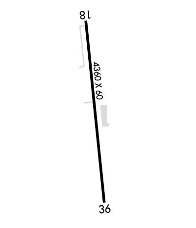
| Lat: N 2858.7 Long: W 08055.5 Elev: 11 Var: +07 Longest Runway: 4360 | ||
| CTAF: 122.7 | ||
| ||||||
|
| Rwy | Rwy | |||||||
| 4360x60 | 4045' | 4360x60 | 4160' | |||||
| Runway ID | Single Wheel | Double Wheel | Double Tandem Wheel | Dual Double Wheel |
| 18/36 | N/A | N/A | N/A | N/A |
| These numbers are Advisory and are not limits. The Airport Manager should have more accurate Weight Limits | ||||
 Airport Diagram might not be current. | |
| Facility Name: | MASSEY RANCH AIRPARK |
| City Name: | NEW SMYRNA BEACH |
| County: | VOLUSIA |
| State abbrev: | FL |
| State Name: | FLORIDA |
| Ownership: | PRIVATELY OWNED |
| Use: | OPEN TO THE PUBLIC |
| Owner's Name: | MASSEY RANCH AIRPARK |
| Address: | PO BOX 1947 |
| NEW SMYRA BEACH, FL 32170-1947 | |
| Owner's Phone: | 386-428-3818 |
| Manager's Name: | JOHN MASSEY; AIRPORT PHYSICAL ADDRESS: 635 AIRPORT ROAD EDGEWATER, FL 32132. |
| Address: | MASSEY RANCH AIRPARK, PO BOX 1947 |
| NEW SMYRA BEACH, FL 32170-1947 | |
| Phone: | 386-428-3818 |
| FAA Region: | SOUTHERN |
| FAA Field Office: | ORL |
| Date | Sunrise | Sunset |
|---|---|---|
| 09/24/21 Friday | 7:13 | 19:18 |
| 09/25/21 Saturday | 7:13 | 19:17 |
| 09/26/21 Sunday | 7:14 | 19:16 |
| 09/27/21 Monday | 7:15 | 19:14 |
| 09/28/21 Tuesday | 7:15 | 19:13 |
| 09/29/21 Wednesday | 7:16 | 19:12 |
| 09/30/21 Thursday | 7:16 | 19:11 |
| 10/01/21 Friday | 7:17 | 19:10 |
| 10/02/21 Saturday | 7:17 | 19:09 |
| 10/03/21 Sunday | 7:18 | 19:07 |
| 10/04/21 Monday | 7:18 | 19:06 |
| 10/05/21 Tuesday | 7:19 | 19:05 |
| 10/06/21 Wednesday | 7:19 | 19:04 |
| 10/07/21 Thursday | 7:20 | 19:03 |
| Airport Attendance Schedule | MON-FRI 0900-1700, SAT-SUN IREG |
| Airport Status | OPERATIONAL (This Status can change at any time - please check NOTAMS) |
| Airport Lighting Schedule | SS-SR |
| Airport Storage Available | Tie Downs |
| Extra Services Available | Avionics, Flight Instruction |
| Wind Indicator | YES - (lighted) |
| Control Tower | NO |
| CTAF Frequency | 122.700 |
| Unicom Frequency | 122.700 |
| Rotating Beacon Color | |
| Segmented Circle | NO |
| Landing Fee | NO |
| Airport Inspected | STATE - performed by STATE AERONAUTICAL PERSONNEL |
| Inspection Date | 08/15/2018 |
| Type of Fuel Available | Grade 100LL, JET A (freeze point -40C); -10SELF SERVICE. |
| Airframe Repair Service | MAJOR |
| Power Plant Repair Service | MAJOR |
| Latitude | N2858.7 |
| Longitude | W08055.5 (ESTIMATED) |
| Arpt Elevation | 10ft (SURVEYED) |
| Magnetic Variation | 07W |
| 3 miles S | of NEW SMYRNA BEACH |
| Traffic Pattern Altitude | |
| Sectional Chart | JACKSONVILLE |
| Operations (Reported) | Yearly | Avg. Daily |
|---|---|---|
| General Aviation Transient | 4000 | 11 |
| General Aviation Local | 5750 | 16 |
| Air Taxi | 0 | 0 |
| Commerical | 0 | 0 |
| Commuter | 0 | 0 |
| Military | 0 | 0 |
| Aircraft based on Field | |
|---|---|
| General Aviation Singles | 75 |
| General Aviation Multi | 12 |
| Jet Aircraft | 1 |
| General Aviation Helicopters | 5 |
| Military Aircraft | 0 |
| Gliders | 4 |
| Ultralights | 1 |
| FSS on field | NO |
| FSS tie-in | SAINT PETERSBURG |
| FSS Phone | 1-800-WX-BRIEF |
| Who issues Notams | PIE |
| Notam D service at airport | YES |
| ARTCC Name | JACKSONVILLE |
| Airport Certification | |
| Aircraft Rescue & Firefighting Index | None |
| Airport of Entry | No |
| Custom Landing Rights | No |
| Joint Civil/Military | No |
| Military Landing rights | No |
| GLIDER, BANNER TOWING, AEROBATICS & PARACHUTING ACTIVITY ON & INVOF ARPT. |
| ACFT MAINT CALL 386-426-6346. |
| FOR CD OR TO CNL IFR CTC DAB APCH AT 386-226-3939. |
| UNLGTD OBSTNS, TREES 55 FT TALL, 725 FT BFR THE AER PRSNT IN THE APCH TO RWY 36. |
| RWY 18/3 6 RY 18/36 LIRLS ARE POSITIONED 20 FT EITHER SIDE OF RY. |
Airport Communications & Frequencies:
| ||||||||||||||
| Runway: 18 | Runway: 36 | ||
| Mag heading: | 181° | Mag heading: | 1° |
| Rwy Slope: | .00% Down | Rwy Slope: | .00% Up |
| Approach: | Approach: | ||
| Pattern: | Left Traffic | Pattern: | Left Traffic |
| Markings: | NONPRECISION INSTRUMENT | Markings: | NONPRECISION INSTRUMENT |
| Marking Condition: | FAIR | Marking Condition: | FAIR |
| Arresting Dev: | Arresting Dev: | ||
| Lat & Long: | N2859.1 W08055.5 | Lat. & Long.: | N2858.4 W08055.4 |
| Elev: | 10.1 ft. MSL | Elev: | 9.9 ft. MSL |
| TCH: | TCH: | ||
| Visual Glide Path: | Visual Glide Path: | ||
| Displaced Threshold: | 315 feet | Displaced Threshold: | 200 feet |
| Touchdown Zone: | YES | Touchdown Zone: | YES |
| Touchdown Elev.: | 10.6 feet | Touchdown Elev.: | 10.6 feet |
| Visual Glide Slope: | Visual Glide Slope: | ||
| RVR Equipment: | RVR Equipment: | ||
| RVV Equipment: | NO | RVV Equipment: | NO |
| Approach Lights: | Approach Lights: | ||
| REIL: | NO | REIL: | NO |
| Centerline Lights: | NO | Centerline Lights: | NO |
| Touchdown lights: | NO | Touchdown lights: | NO |
| Runway Category: | Runway with a Visual Approach | Runway Category: | Runway with a Visual Approach |
| Declared Distances: | Declared Distances: | ||
| Obstructions: | ROAD | Obstructions: | ROAD |
| Marked: | NOT Marked/Lighted | Marked: | NOT Marked/Lighted |
| Clearance slope: | 4:1; RYW 18 APCH RATIO 20:1 TO DISP THLD DUE TO TREES 53 FT 830 FT FM END OF RWY 115 FT L OF CNTRLN. | Clearance slope: | 10:1; RY 36 APCH RATIO 15:1 DUE TO TREE 53 FT 592 FT FROM END OF RY 135 FT L OF CNTRLN. |
| Obstruction height: | 17 feet AGL | Obstruction height: | 15 feet AGL |
| Dist. from runway: | 275 feet | Dist. from runway: | 360 feet |
| Centerline offset: | 125 left of centerline; TREES L & R 125 FT FM CNTRLN OF RY. | Centerline offset: | 125 feet left of centerline |
| Comments: | Comments: |
Thanks for using FltPlan.com
all rights reserved © 1999-2021 by Flight Plan LLC
