
| CAMP PEARY LANDING STRIP (PVT) WILLIAMSBURG VA |
| |
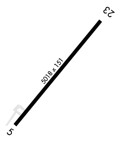
| Lat: N 3718.8 Long: W 07638.3 Elev: 41 Var: +11 Longest Runway: 5018 | ||
| CTAF: 122.8 | ||
| ||||||||||||||||||||||||||||||||
| ||||||||||||||||||||||||||||||||
| Rwy | Rwy | |||||||
| 5018x151 | 5018' | 5018x151 | 5018' | |||||
| Runway ID | Single Wheel | Double Wheel | Double Tandem Wheel | Dual Double Wheel |
| 05/23 | N/A | N/A | N/A | N/A |
| These numbers are Advisory and are not limits. The Airport Manager should have more accurate Weight Limits | ||||
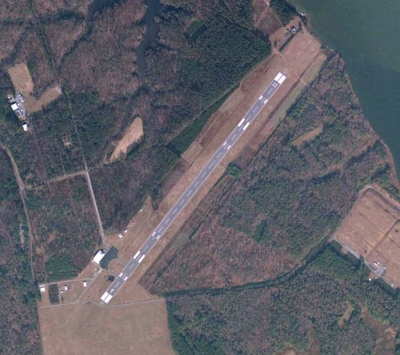
 Airport Diagram might not be current. | |
| Facility Name: | CAMP PEARY LNDG STRIP |
| City Name: | WILLIAMSBURG |
| County: | YORK |
| State abbrev: | VA |
| State Name: | VIRGINIA |
| Ownership: | ARMY OWNED |
| Use: | PRIVATE; THIS FLD IS DOD RESTRICTED. |
| Owner's Name: | US ARMY AERONAUTICAL SVCS AGENCY |
| Address: | |
| FT BELVOIR, VA 22060 | |
| Owner's Phone: | |
| Manager's Name: | DAVID J CROMLEY; COLONEL INFANTRY. |
| Address: | AFETA-CAMP PEARY |
| WILLIAMSBURG, VA 23185 | |
| Phone: | 804-229-2121 |
| FAA Region: | EASTERN |
| FAA Field Office: | DCA |
| Date | Sunrise | Sunset |
|---|---|---|
| 09/24/21 Friday | 6:56 | 19:01 |
| 09/25/21 Saturday | 6:57 | 18:59 |
| 09/26/21 Sunday | 6:57 | 18:58 |
| 09/27/21 Monday | 6:58 | 18:56 |
| 09/28/21 Tuesday | 6:59 | 18:55 |
| 09/29/21 Wednesday | 7:00 | 18:53 |
| 09/30/21 Thursday | 7:01 | 18:52 |
| 10/01/21 Friday | 7:02 | 18:50 |
| 10/02/21 Saturday | 7:03 | 18:49 |
| 10/03/21 Sunday | 7:03 | 18:47 |
| 10/04/21 Monday | 7:04 | 18:46 |
| 10/05/21 Tuesday | 7:05 | 18:44 |
| 10/06/21 Wednesday | 7:06 | 18:43 |
| 10/07/21 Thursday | 7:07 | 18:41 |
| Airport Attendance Schedule | MON-FRI 0800-1630 |
| Airport Status | OPERATIONAL (This Status can change at any time - please check NOTAMS) |
| Airport Lighting Schedule | SS-SR |
| Airport Storage Available | NONE |
| Extra Services Available | NONE |
| Wind Indicator | YES - (unlit) |
| Control Tower | NO |
| CTAF Frequency | |
| Unicom Frequency | |
| Rotating Beacon Color | |
| Segmented Circle | NO |
| Landing Fee | NO |
| Airport Inspected | No Inspection Data Available performed by the OWNER |
| Inspection Date | Unknown |
| Type of Fuel Available | None |
| Airframe Repair Service | NONE |
| Power Plant Repair Service | NONE |
| Latitude | N3718.8 |
| Longitude | W07638.3 (ESTIMATED) |
| Arpt Elevation | 40ft (ESTIMATED) |
| Magnetic Variation | 11W |
| 3 miles NE | of WILLIAMSBURG |
| Traffic Pattern Altitude | |
| Sectional Chart | WASHINGTON |
| Operations (Reported) | Yearly | Avg. Daily |
|---|---|---|
| General Aviation Transient | 0 | 0 |
| General Aviation Local | 0 | 0 |
| Air Taxi | 0 | 0 |
| Commerical | 0 | 0 |
| Commuter | 0 | 0 |
| Military | 0 | 0 |
| Aircraft based on Field | |
|---|---|
| General Aviation Singles | 0 |
| General Aviation Multi | 0 |
| Jet Aircraft | 0 |
| General Aviation Helicopters | 0 |
| Military Aircraft | 0 |
| Gliders | 0 |
| Ultralights | 0 |
| FSS on field | NO |
| FSS tie-in | LEESBURG |
| FSS Phone | 1-800-WX-BRIEF |
| Who issues Notams | DCA |
| Notam D service at airport | YES |
| ARTCC Name | WASHINGTON |
| Airport Certification | |
| Aircraft Rescue & Firefighting Index | None |
| Airport of Entry | No |
| Custom Landing Rights | No |
| Joint Civil/Military | No |
| Military Landing rights | No |
| CAUTION: FLD RSTD, PPR BY WRITTEN REQ TO BASE COMDR, ATTN: AIR OPS. EXC WHEN OPR UNDER PRIOR PERMS AUTH, PILOTS SHOULD MAINT AT LEAST 3000 FT ABV THE ARPT ELEV WITHIN 5 NM. |
| FOR CD CTC NORFOLK APCH AT 757-464-0757. |
| RWY 05/2 3 FLD CLSD TO ALL CIV & MIL ACFT WO PRIOR APVL OF BASE COMDR. |
Airport Communications & Frequencies:
| |||||||||||||
| Runway: 05 | Runway: 23 | ||
| Mag heading: | N/A | Mag heading: | N/A |
| Rwy Slope: | -.19% Down | Rwy Slope: | .19% Up |
| Approach: | Approach: | ||
| Pattern: | Left Traffic | Pattern: | Left Traffic |
| Markings: | Markings: | ||
| Marking Condition: | Marking Condition: | ||
| Arresting Dev: | Arresting Dev: | ||
| Lat & Long: | N3718.4 W07638.6 | Lat. & Long.: | N3719.1 W07638.0 |
| Elev: | 40.8 ft. MSL | Elev: | 31.3 ft. MSL |
| TCH: | TCH: | ||
| Visual Glide Path: | Visual Glide Path: | ||
| Displaced Threshold: | No | Displaced Threshold: | No |
| Touchdown Zone: | YES | Touchdown Zone: | YES |
| Touchdown Elev.: | 40.8 feet | Touchdown Elev.: | 34.3 feet |
| Visual Glide Slope: | 4-Light PAPI on LEFT side of Runway | Visual Glide Slope: | 4-Light PAPI on LEFT side of Runway |
| RVR Equipment: | RVR Equipment: | ||
| RVV Equipment: | NO | RVV Equipment: | NO |
| Approach Lights: | Approach Lights: | ||
| REIL: | NO | REIL: | NO |
| Centerline Lights: | NO | Centerline Lights: | NO |
| Touchdown lights: | NO | Touchdown lights: | NO |
| Runway Category: | Runway Category: | ||
| Declared Distances: | Declared Distances: |
Thanks for using FltPlan.com
all rights reserved © 1999-2021 by Flight Plan LLC