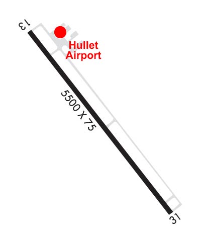
| HULETT MUNI HULETT WY |
| |
| Lat: N 4439.8 Long: W 10434.1 Elev: 4264 Var: -10 Longest Runway: 5500 | ||
| AWOS: 128.77 CTAF: 122.8 | ||
| ||||||||||||||||||||||||||||||
| ||||||||||||||||||||||||||||||
| ||||||||||||||||||||||||||||||
| Rwy | Rwy | |||||||
| 5500x75 | 5500' | 5500x75 | 5500' | |||||
| Runway ID | Single Wheel | Double Wheel | Double Tandem Wheel | Dual Double Wheel |
| 13/31 | 12,500 | N/A | N/A | N/A |
| These numbers are Advisory and are not limits. The Airport Manager should have more accurate Weight Limits | ||||
 Airport Diagram might not be current. | |
| Facility Name: | HULETT MUNI |
| City Name: | HULETT |
| County: | CROOK |
| State abbrev: | WY |
| State Name: | WYOMING |
| Ownership: | PUBLICLY OWNED |
| Use: | OPEN TO THE PUBLIC |
| Owner's Name: | TOWN OF HULETT |
| Address: | P.O. BOX 278 |
| HULETT, WY 82720 | |
| Owner's Phone: | 307-467-5771 |
| Manager's Name: | TOWN OF HULETT; MELISSA BEARS, TOWN CLERK |
| Address: | P.O. BOX 278 |
| HULETT, WY 82720 | |
| Phone: | 307-467-5771 |
| FAA Region: | NORTHWEST MOUNTAIN |
| FAA Field Office: | DEN |
| Date | Sunrise | Sunset |
|---|---|---|
| 06/07/26 Sunday | 5:13 | 20:41 |
| 06/08/26 Monday | 5:13 | 20:42 |
| 06/09/26 Tuesday | 5:13 | 20:42 |
| 06/10/26 Wednesday | 5:13 | 20:43 |
| 06/11/26 Thursday | 5:13 | 20:43 |
| 06/12/26 Friday | 5:12 | 20:44 |
| 06/13/26 Saturday | 5:12 | 20:44 |
| 06/14/26 Sunday | 5:12 | 20:45 |
| 06/15/26 Monday | 5:12 | 20:45 |
| 06/16/26 Tuesday | 5:12 | 20:46 |
| 06/17/26 Wednesday | 5:12 | 20:46 |
| 06/18/26 Thursday | 5:12 | 20:46 |
| 06/19/26 Friday | 5:12 | 20:47 |
| 06/20/26 Saturday | 5:13 | 20:47 |
| Airport Attendance Schedule | UNATTENDED |
| Airport Status | OPERATIONAL (This Status can change at any time - please check NOTAMS) |
| Airport Lighting Schedule | ACTVT REIL RWY 13 & 31; PAPI RWY 13 & 31; MIRL 13/31 - CTAF. |
| Airport Storage Available | Tie Downs |
| Extra Services Available | NONE |
| Wind Indicator | YES - (lighted) |
| Control Tower | NO |
| CTAF Frequency | 122.800 |
| Unicom Frequency | 122.800 |
| Rotating Beacon Color | WG |
| Segmented Circle | YES |
| Landing Fee |
| Airport Inspected | STATE - performed by STATE AERONAUTICAL PERSONNEL |
| Inspection Date | 05/29/2024 |
| Type of Fuel Available | Grade 100LL, JET A (freeze point -40C); -1024 HR SELF SVC CREDIT CARD FUEL AVBL. |
| Airframe Repair Service | NONE |
| Power Plant Repair Service | NONE |
| Latitude | N4439.8 |
| Longitude | W10434.1 (ESTIMATED) |
| Arpt Elevation | 4263ft (SURVEYED) |
| Magnetic Variation | 10E |
| 2 miles SE | of HULETT |
| Traffic Pattern Altitude | |
| Sectional Chart | BILLINGS |
| Operations (Reported) | Yearly | Avg. Daily |
|---|---|---|
| General Aviation Transient | 0 | 0 |
| General Aviation Local | 0 | 0 |
| Air Taxi | 0 | 0 |
| Commerical | 0 | 0 |
| Commuter | 0 | 0 |
| Military | 0 | 0 |
| Aircraft based on Field | |
|---|---|
| General Aviation Singles | 0 |
| General Aviation Multi | 0 |
| Jet Aircraft | 0 |
| General Aviation Helicopters | 0 |
| Military Aircraft | 0 |
| Gliders | 0 |
| Ultralights | 0 |
| FSS on field | NO |
| FSS tie-in | CASPER |
| FSS Phone | 1-800-WX-BRIEF |
| Who issues Notams | CPR |
| Notam D service at airport | YES |
| ARTCC Name | DENVER |
| Airport Certification | |
| Aircraft Rescue & Firefighting Index | None |
| Airport of Entry | No |
| Custom Landing Rights | No |
| Joint Civil/Military | No |
| Military Landing rights | No |
| NATIONAL PLAN OF INTEGRATED AIRPORT SYSTEMS (NPIAS) |
| GRANT AGREEMENTS UNDER FAAP/ADAP/AIP |
| ASSURANCES PURSUANT TO TITLE VI, CIVIL RIGHTS ACT OF 1964 |
| DEVILS TOWER NATIONAL MONUMENT LOCATED APRXLY 7 MILES SW OF THE ARPT. VOLUNTARY 2 MILE FLIGHT AVOIDANCE RADIUS IN EFFECT JAN-MAY AND JUL-DEC. VOLUNTARY 3 MILE FLIGHT AVOIDANCE RADIUS IN EFFECT IN JUN. |
| RETRO-REFLECTIVE MARKERS ALONG TAXIWAYS |
| FOR CD CTC DENVER ARTCC AT 303-651-4257. |
Airport Communications & Frequencies:
| |||||||||
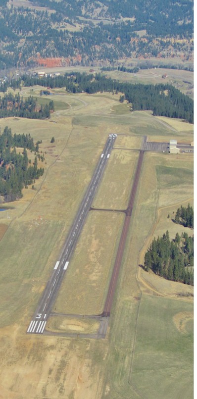
| Runway: 13 | Runway: 31 | ||
| Mag heading: | 132° | Mag heading: | 312° |
| Rwy Slope: | 1.25% Up | Rwy Slope: | -1.25% Down |
| Approach: | Approach: | ||
| Pattern: | Left Traffic | Pattern: | Right Traffic |
| Markings: | NONPRECISION INSTRUMENT | Markings: | NONPRECISION INSTRUMENT |
| Marking Condition: | FAIR | Marking Condition: | FAIR |
| Arresting Dev: | Arresting Dev: | ||
| Lat & Long: | N4440.1 W10434.5 | Lat. & Long.: | N4439.4 W10433.7 |
| Elev: | 4194.8 ft. MSL | Elev: | 4263.7 ft. MSL |
| TCH: | 38 ft. AGL | TCH: | 44 ft. AGL |
| Visual Glide Path: | 3.00 degrees | Visual Glide Path: | 4.00 degrees |
| Displaced Threshold: | No | Displaced Threshold: | No |
| Touchdown Zone: | YES | Touchdown Zone: | YES |
| Touchdown Elev.: | 4227.1 feet | Touchdown Elev.: | 4263.7 feet |
| Visual Glide Slope: | 2-Light PAPI on LEFT side of Runway | Visual Glide Slope: | 2-Light PAPI on LEFT side of Runway |
| RVR Equipment: | RVR Equipment: | ||
| RVV Equipment: | NO | RVV Equipment: | NO |
| Approach Lights: | Approach Lights: | ||
| REIL: | YES | REIL: | YES |
| Centerline Lights: | NO | Centerline Lights: | NO |
| Touchdown lights: | NO | Touchdown lights: | NO |
| Runway Category: | Runway with a Non-precision Approach | Runway Category: | Runway with a Visual Approach |
| Declared Distances: | Declared Distances: | ||
| Obstructions: | Obstructions: | HILL | |
| Marked: | Marked: | NOT Marked/Lighted | |
| Clearance slope: | 20:1 | Clearance slope: | 22:1 |
| Obstruction height: | Obstruction height: | 165 feet AGL | |
| Dist. from runway: | Dist. from runway: | 3900 feet | |
| Centerline offset: | Centerline offset: | 425 feet right of centerline | |
| Comments: | Comments: |
Thanks for using FltPlan.com
all rights reserved © 1999-2026 by Flight Plan LLC