
| VENICE MUNI VENICE FL |
| |
| Lat: N 2704.3 Long: W 08226.4 Elev: 18 Var: +05 Longest Runway: 5640 | ||
| Clr Del: 118.075 AWOS: 119.27 CTAF: 122.72 | ||
| ||||||||||||||||||||||||||||||||||||||||||||
| ||||||||||||||||||||||||||||||||||||||||||||
| ||||||||||||||||||||||||||||||||||||||||||||
| ||||||||||||||||||||||||||||||||||||||||||||
| ||||||||||||||||||||||||||||||||||||||||||||
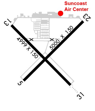
| Rwy | Rwy | |||||||
| 5000x150 | 5000' | 5000x150 | 4537' | |||||
| 5640x150 | 5001' | 5640x150 | 5001' | |||||
| Runway ID | Single Wheel | Double Wheel | Double Tandem Wheel | Dual Double Wheel |
| 05/23 | 75,000 | 108,000 | N/A | N/A |
| 13/31 | 75,000 | 108,000 | N/A | N/A |
| These numbers are Advisory and are not limits. The Airport Manager should have more accurate Weight Limits | ||||
 Airport Diagram might not be current. | |
| Facility Name: | VENICE MUNI |
| City Name: | VENICE |
| County: | SARASOTA |
| State abbrev: | FL |
| State Name: | FLORIDA |
| Ownership: | PUBLICLY OWNED |
| Use: | OPEN TO THE PUBLIC |
| Owner's Name: | CITY OF VENICE |
| Address: | 401 WEST VENICE AVE |
| VENICE, FL 34285 | |
| Owner's Phone: | 941-486-2626 |
| Manager's Name: | MARK J. CERVASIO |
| Address: | 150 EAST AIRPORT AVE |
| VENICE, FL 34285 | |
| Phone: | 941-486-2711 |
| FAA Region: | SOUTHERN |
| FAA Field Office: | ORL |

| Date | Sunrise | Sunset |
|---|---|---|
| 11/07/25 Friday | 6:44 | 17:43 |
| 11/08/25 Saturday | 6:45 | 17:42 |
| 11/09/25 Sunday | 6:45 | 17:42 |
| 11/10/25 Monday | 6:46 | 17:41 |
| 11/11/25 Tuesday | 6:47 | 17:41 |
| 11/12/25 Wednesday | 6:47 | 17:40 |
| 11/13/25 Thursday | 6:48 | 17:40 |
| 11/14/25 Friday | 6:49 | 17:39 |
| 11/15/25 Saturday | 6:50 | 17:39 |
| 11/16/25 Sunday | 6:50 | 17:38 |
| 11/17/25 Monday | 6:51 | 17:38 |
| 11/18/25 Tuesday | 6:52 | 17:38 |
| 11/19/25 Wednesday | 6:53 | 17:37 |
| 11/20/25 Thursday | 6:53 | 17:37 |
| Airport Attendance Schedule | 7 Days A Week 0700-1900 |
| Airport Status | OPERATIONAL (This Status can change at any time - please check NOTAMS) |
| Airport Lighting Schedule | ACTVT REIL RWY 5, 23, & 13; MIRL RWY 5/23, 13/31 - CTAF. |
| Airport Storage Available | Tie Downs, Hanger |
| Extra Services Available | Avionics, Charter, Flight Instruction, Aircraft Rental, Aircraft Sales |
| Wind Indicator | YES - (lighted) |
| Control Tower | NO |
| CTAF Frequency | 122.725 |
| Unicom Frequency | 122.725 |
| Rotating Beacon Color | WG |
| Segmented Circle | Y-L |
| Landing Fee | NO |
| Airport Inspected | STATE - performed by STATE AERONAUTICAL PERSONNEL |
| Inspection Date | 10/13/2025 |
| Type of Fuel Available | Grade 100LL, JET A (freeze point -40C) |
| Airframe Repair Service | MAJOR |
| Power Plant Repair Service | MAJOR |
| Latitude | N2704.3 |
| Longitude | W08226.4 (ESTIMATED) |
| Arpt Elevation | 18ft (SURVEYED) |
| Magnetic Variation | 05W |
| 2 miles S | of VENICE |
| Traffic Pattern Altitude | |
| Sectional Chart | MIAMI |
| Operations (Reported) | Yearly | Avg. Daily |
|---|---|---|
| General Aviation Transient | 0 | 0 |
| General Aviation Local | 0 | 0 |
| Air Taxi | 0 | 0 |
| Commerical | 0 | 0 |
| Commuter | 0 | 0 |
| Military | 0 | 0 |
| Aircraft based on Field | |
|---|---|
| General Aviation Singles | 0 |
| General Aviation Multi | 0 |
| Jet Aircraft | 0 |
| General Aviation Helicopters | 0 |
| Military Aircraft | 0 |
| Gliders | 0 |
| Ultralights | 0 |
| FSS on field | NO |
| FSS tie-in | SAINT PETERSBURG |
| FSS Phone | 1-800-WX-BRIEF |
| Who issues Notams | PIE |
| Notam D service at airport | YES |
| ARTCC Name | MIAMI |
| Airport Certification | |
| Aircraft Rescue & Firefighting Index | None |
| Airport of Entry | No |
| Custom Landing Rights | No |
| Joint Civil/Military | No |
| Military Landing rights | YES |
| NATIONAL PLAN OF INTEGRATED AIRPORT SYSTEMS (NPIAS) |
| GRANT AGREEMENTS UNDER FAAP/ADAP/AIP |
| SURPLUS PROPERTY AGREEMENT UNDER PUBLIC LAW 289 |
| SURPLUS PROPERTY AGREEMENT UNDER REGULATION 16-WAA |
| ASSURANCES PURSUANT TO TITLE VI, CIVIL RIGHTS ACT OF 1964 |
| NOISE ABATEMENT PROCEDURES IN EFFECT, CALL AMGR 941-486-2711. |
| ARPT SFC CONDS NOT RPRTD. |
| FOR CD CTC TAMPA APCH AT 813-878-2528 |
| ARPT HAS EXTENSIVE FLIGHT TRAINING. |
| BIRD AND WILDLIFE ON AND INVOF THE ARPT. |
| PAEW ADJ TO ALL RYS AND TWYS DURG DALGT HRS. |
| PPR FOR ACFT EXCEEDING RY WEIGHT BEARING CAPACITY. |
| PARASAILING ACTIVITY WEST THE ARPT ALONG BEACH. |
| RY 23 IS CALM WIND RY. |
| RWY 05 RWY 05/23 PREF APCH. |
| RWY 23 PREF DEP CALM WIND RWY. |
Airport Communications & Frequencies:
| ||||||||||||||||||||
| Runway: 05 | Runway: 23 | ||
| Mag heading: | 50° | Mag heading: | 230° |
| Rwy Slope: | .10% Up | Rwy Slope: | -.10% Down |
| Approach: | Approach: | ||
| Pattern: | Left Traffic | Pattern: | Left Traffic |
| Markings: | NONPRECISION INSTRUMENT | Markings: | NONPRECISION INSTRUMENT |
| Marking Condition: | GOOD | Marking Condition: | GOOD |
| Arresting Dev: | Arresting Dev: | ||
| Lat & Long: | N2704.0 W08226.7 | Lat. & Long.: | N2704.6 W08226.0 |
| Elev: | 12.4 ft. MSL | Elev: | 17.4 ft. MSL |
| TCH: | 43 ft. AGL | TCH: | 48 ft. AGL |
| Visual Glide Path: | 3.00 degrees | Visual Glide Path: | 3.00 degrees |
| Displaced Threshold: | No | Displaced Threshold: | 463 feet |
| Touchdown Zone: | YES | Touchdown Zone: | YES |
| Touchdown Elev.: | 17.7 feet | Touchdown Elev.: | 18.1 feet |
| Visual Glide Slope: | 2-Light PAPI on LEFT side of Runway | Visual Glide Slope: | 2-Light PAPI on LEFT side of Runway |
| RVR Equipment: | RVR Equipment: | ||
| RVV Equipment: | NO | RVV Equipment: | NO |
| Approach Lights: | Approach Lights: | ||
| REIL: | YES | REIL: | YES |
| Centerline Lights: | NO | Centerline Lights: | NO |
| Touchdown lights: | NO | Touchdown lights: | NO |
| Runway Category: | Runway with a Non-precision Approach having visibility minimums greater than 3/4 mile | Runway Category: | Runway with a Non-precision Approach having visibility minimums greater than 3/4 mile |
| Declared Distances: | Declared Distances: | TORA:5000' TODA:5000' ASDA:4840' LDA:4377' | |
| Obstructions: | TREES | Obstructions: | BRDG |
| Marked: | NOT Marked/Lighted | Marked: | LIGHTED |
| Clearance slope: | 50:1 | Clearance slope: | 18:1; RWY 23 APCH RATIO 30:1 TO DTHR. |
| Obstruction height: | 14 feet AGL | Obstruction height: | 55 feet AGL |
| Dist. from runway: | 865 feet | Dist. from runway: | 1190 feet |
| Centerline offset: | 225 left of centerline | Centerline offset: | 90 feet left of centerline |
| Comments: | Comments: |
| Runway: 13 | Runway: 31 | ||
| Mag heading: | 140° | Mag heading: | 320° |
| Rwy Slope: | .02% Up | Rwy Slope: | -.02% Down |
| Approach: | Approach: | ||
| Pattern: | Right Traffic | Pattern: | Left Traffic |
| Markings: | NONPRECISION INSTRUMENT | Markings: | NONPRECISION INSTRUMENT |
| Marking Condition: | GOOD | Marking Condition: | GOOD |
| Arresting Dev: | Arresting Dev: | EMAS | |
| Lat & Long: | N2704.6 W08226.8 | Lat. & Long.: | N2703.9 W08226.1 |
| Elev: | 14.9 ft. MSL | Elev: | 16.3 ft. MSL |
| TCH: | 46 ft. AGL | TCH: | 40 ft. AGL |
| Visual Glide Path: | 3.00 degrees | Visual Glide Path: | 3.00 degrees |
| Displaced Threshold: | 639 feet | Displaced Threshold: | 639 feet |
| Touchdown Zone: | YES | Touchdown Zone: | YES |
| Touchdown Elev.: | 16.5 feet | Touchdown Elev.: | 16.5 feet |
| Visual Glide Slope: | 4-Light PAPI on LEFT side of Runway | Visual Glide Slope: | 4-Light PAPI on LEFT side of Runway |
| RVR Equipment: | RVR Equipment: | ||
| RVV Equipment: | NO | RVV Equipment: | NO |
| Approach Lights: | Approach Lights: | ||
| REIL: | YES | REIL: | YES |
| Centerline Lights: | NO | Centerline Lights: | NO |
| Touchdown lights: | NO | Touchdown lights: | NO |
| Runway Category: | Runway with a Non-precision Approach having visibility minimums greater than 3/4 mile | Runway Category: | Runway with a Non-precision Approach having visibility minimums greater than 3/4 mile |
| Declared Distances: | TORA:5000' TODA:5000' ASDA:5000' LDA:5000' | Declared Distances: | TORA:5000' TODA:5000' ASDA:5000' LDA:5000' |
| Obstructions: | TREES | Obstructions: | TREE |
| Marked: | NOT Marked/Lighted | Marked: | NOT Marked/Lighted |
| Clearance slope: | 23:1; RWY 13 APCH SLOPE 45:1 TO DTHR. | Clearance slope: | 15:1; RWY 31 APCH SLOPE 34:1 TO DTHR. |
| Obstruction height: | 40 feet AGL | Obstruction height: | 45 feet AGL |
| Dist. from runway: | 1155 feet | Dist. from runway: | 890 feet |
| Centerline offset: | 255 right of centerline | Centerline offset: | 110 feet right of centerline |
| Comments: | Comments: |
Thanks for using FltPlan.com
all rights reserved © 1999-2025 by Flight Plan LLC