
| VICKSBURG MUNI VICKSBURG MS |
| |
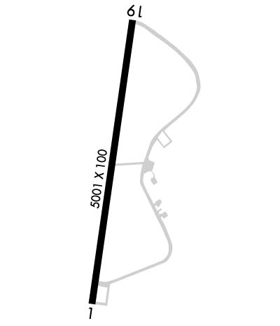
| Lat: N 3214.3 Long: W 09055.7 Elev: 107 Var: +00 Longest Runway: 5001 | ||
| AWOS: 118.85 CTAF: 122.8 | ||
| ||||||||||||||||||||||||||||||||||||||||||||
| ||||||||||||||||||||||||||||||||||||||||||||
| ||||||||||||||||||||||||||||||||||||||||||||
| Rwy | Rwy | |||||||
| 5001x100 | 4702' | 5001x100 | 4529' | |||||
| Runway ID | Single Wheel | Double Wheel | Double Tandem Wheel | Dual Double Wheel |
| 01/19 | 30,000 | 50,000 | 90,000 | N/A |
| These numbers are Advisory and are not limits. The Airport Manager should have more accurate Weight Limits | ||||
 Airport Diagram might not be current. | |
| Facility Name: | VICKSBURG MUNI |
| City Name: | VICKSBURG |
| County: | WARREN |
| State abbrev: | MS |
| State Name: | MISSISSIPPI |
| Ownership: | PUBLICLY OWNED |
| Use: | OPEN TO THE PUBLIC |
| Owner's Name: | CITY OF VICKSBURG |
| Address: | PO BOX 150 |
| VICKSBURG, MS 39180 | |
| Owner's Phone: | 601-634-4525 |
| Manager's Name: | RON DAVIS |
| Address: | 5855 HIGHWAY 61 SOUTH |
| VICKSBURG, MS 39180 | |
| Phone: | 601-218-5789; 601-218-5789 OR 601-636-4925. |
| FAA Region: | SOUTHERN |
| FAA Field Office: | JAN |
| Date | Sunrise | Sunset |
|---|---|---|
| 09/24/21 Friday | 6:53 | 18:58 |
| 09/25/21 Saturday | 6:54 | 18:57 |
| 09/26/21 Sunday | 6:54 | 18:55 |
| 09/27/21 Monday | 6:55 | 18:54 |
| 09/28/21 Tuesday | 6:56 | 18:53 |
| 09/29/21 Wednesday | 6:56 | 18:51 |
| 09/30/21 Thursday | 6:57 | 18:50 |
| 10/01/21 Friday | 6:58 | 18:49 |
| 10/02/21 Saturday | 6:58 | 18:47 |
| 10/03/21 Sunday | 6:59 | 18:46 |
| 10/04/21 Monday | 7:00 | 18:45 |
| 10/05/21 Tuesday | 7:00 | 18:44 |
| 10/06/21 Wednesday | 7:01 | 18:42 |
| 10/07/21 Thursday | 7:02 | 18:41 |
| Airport Attendance Schedule | MON-FRI 0730-1630; AFT HRS CALL 601-218-5428. CALL OUT FEE RQRD. |
| Airport Status | OPERATIONAL (This Status can change at any time - please check NOTAMS) |
| Airport Lighting Schedule | ACTVT PAPI RWY 19; MIRL RWY 01/19 - CTAF. PAPI RWY 01 OPR CONSLY. |
| Airport Storage Available | Tie Downs, Hanger |
| Extra Services Available | Flight Instruction |
| Wind Indicator | YES - (lighted) |
| Control Tower | NO |
| CTAF Frequency | 122.800 |
| Unicom Frequency | 122.800 |
| Rotating Beacon Color | CLEAR-GREEN (Light Land Airport) |
| Segmented Circle | YES |
| Landing Fee | NO |
| Airport Inspected | STATE - performed by STATE AERONAUTICAL PERSONNEL |
| Inspection Date | 02/09/2021 |
| Type of Fuel Available | Grade 100LL, JET A-1 (icing inhibitor, freeze point -50C); -10FUEL H24 WITH CREDIT CARD. |
| Airframe Repair Service | NONE; AVBL - 601-529-2909. |
| Power Plant Repair Service | NONE; AVBL - 601-529-2909. |
| Latitude | N3214.3 |
| Longitude | W09055.7 (ESTIMATED) |
| Arpt Elevation | 107ft (SURVEYED) |
| Magnetic Variation | 00W |
| 7 miles SW | of VICKSBURG |
| Traffic Pattern Altitude | |
| Sectional Chart | MEMPHIS |
| Operations (Reported) | Yearly | Avg. Daily |
|---|---|---|
| General Aviation Transient | 419 | 1 |
| General Aviation Local | 950 | 3 |
| Air Taxi | 0 | 0 |
| Commerical | 0 | 0 |
| Commuter | 0 | 0 |
| Military | 156 | 0 |
| Aircraft based on Field | |
|---|---|
| General Aviation Singles | 6 |
| General Aviation Multi | 1 |
| Jet Aircraft | 0 |
| General Aviation Helicopters | 0 |
| Military Aircraft | 0 |
| Gliders | 0 |
| Ultralights | 0 |
| FSS on field | NO |
| FSS tie-in | GREENWOOD |
| FSS Phone | 1-800-WX-BRIEF |
| Who issues Notams | GWO |
| Notam D service at airport | YES |
| ARTCC Name | MEMPHIS |
| Airport Certification | |
| Aircraft Rescue & Firefighting Index | None |
| Airport of Entry | No |
| Custom Landing Rights | YES |
| Joint Civil/Military | No |
| Military Landing rights | YES |
| NATIONAL PLAN OF INTEGRATED AIRPORT SYSTEMS (NPIAS) |
| GRANT AGREEMENT HAS EXPIRED; HOWEVER, AGREEMENT REMAINS IN EFFECT FOR THIS FACILITY AS LONG AS IT IS PUBLIC USE. |
| N PARL TWY CLSD. |
| TERM STUB TWY ONLY. |
| FOR CD CTC MEMPHIS ARTCC AT 901-368-8453/8449. |
Airport Communications & Frequencies:
| |||||||||
| Runway: 01 | Runway: 19 | ||
| Mag heading: | 8° | Mag heading: | 188° |
| Rwy Slope: | .12% Up | Rwy Slope: | -.12% Down |
| Approach: | Approach: | ||
| Pattern: | Left Traffic | Pattern: | Left Traffic |
| Markings: | NONPRECISION INSTRUMENT | Markings: | NONPRECISION INSTRUMENT |
| Marking Condition: | FAIR | Marking Condition: | FAIR |
| Arresting Dev: | Arresting Dev: | ||
| Lat & Long: | N3213.9 W09055.8 | Lat. & Long.: | N3214.8 W09055.6 |
| Elev: | 100.7 ft. MSL | Elev: | 106.8 ft. MSL |
| TCH: | 41 ft. AGL | TCH: | 44 ft. AGL |
| Visual Glide Path: | 3.00 degrees | Visual Glide Path: | 3.00 degrees |
| Displaced Threshold: | 299 feet | Displaced Threshold: | 472 feet |
| Touchdown Zone: | YES | Touchdown Zone: | YES |
| Touchdown Elev.: | 103.9 feet | Touchdown Elev.: | 106.3 feet |
| Visual Glide Slope: | 2-Light PAPI on RIGHT side of Runway | Visual Glide Slope: | 2-Light PAPI on LEFT side of Runway |
| RVR Equipment: | RVR Equipment: | ||
| RVV Equipment: | NO | RVV Equipment: | NO |
| Approach Lights: | Approach Lights: | ||
| REIL: | NO | REIL: | NO |
| Centerline Lights: | NO | Centerline Lights: | NO |
| Touchdown lights: | NO | Touchdown lights: | NO |
| Runway Category: | Runway with a Non-precision Approach having visibility minimums greater than 3/4 mile | Runway Category: | Runway with a Non-precision Approach having visibility minimums greater than 3/4 mile |
| Declared Distances: | Declared Distances: | ||
| Obstructions: | TREES | Obstructions: | TREE |
| Marked: | NOT Marked/Lighted | Marked: | NOT Marked/Lighted |
| Clearance slope: | 21:1; APCH RATIO 28:1 TO DSPLCD THR. | Clearance slope: | 23:1; APCH RATIO 41:1 TO DSPLCD THR. |
| Obstruction height: | 105 feet AGL | Obstruction height: | 38 feet AGL |
| Dist. from runway: | 2500 feet | Dist. from runway: | 1100 feet |
| Centerline offset: | Centerline offset: | 200 feet left of centerline | |
| Comments: | Comments: |
Thanks for using FltPlan.com
all rights reserved © 1999-2021 by Flight Plan LLC
