
| WILKES COUNTY NORTH WILKESBORO NC |
| |
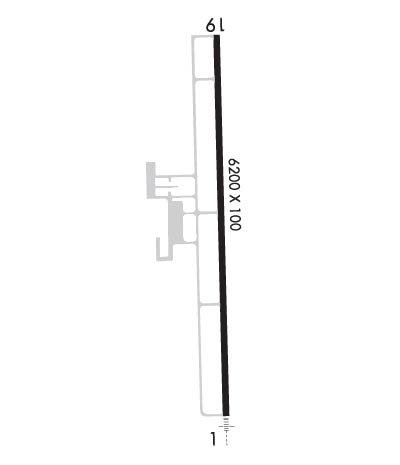
| Lat: N 3613.4 Long: W 08105.9 Elev: 1303 Var: +08 Longest Runway: 6200 | ||
| Clr Del: 122.4 RCO AWOS: 126.62 CTAF: 122.7 | ||
| ||||||||||||||||||||||||||||||||||||||||||||
| ||||||||||||||||||||||||||||||||||||||||||||
| ||||||||||||||||||||||||||||||||||||||||||||
| Rwy | Rwy | |||||||
| 6200x100 | 6200' | 111.55 - 006° | 6200x100 | 6200' | ||||
| Runway ID | Single Wheel | Double Wheel | Double Tandem Wheel | Dual Double Wheel |
| 01/19 | 45,000 | 60,000 | N/A | N/A |
| These numbers are Advisory and are not limits. The Airport Manager should have more accurate Weight Limits | ||||
 Airport Diagram might not be current. | |
| Facility Name: | WILKES COUNTY |
| City Name: | NORTH WILKESBORO |
| County: | WILKES |
| State abbrev: | NC |
| State Name: | NORTH CAROLINA |
| Ownership: | PUBLICLY OWNED |
| Use: | OPEN TO THE PUBLIC |
| Owner's Name: | WILKES COUNTY |
| Address: | 110 NORTH STREET |
| WILKESBORO, NC 28697 | |
| Owner's Phone: | 336-651-7345 |
| Manager's Name: | ROBERT GOSS |
| Address: | 640 WOOD WALLACE |
| NORTH WILKESBORO, NC 28659 | |
| Phone: | 336-696-2000; FOR SVC AFTER HOURS CALL NUMBER POSTED ON DOOR. |
| FAA Region: | SOUTHERN |
| FAA Field Office: | MEM |

| Date | Sunrise | Sunset |
|---|---|---|
| 09/24/21 Friday | 7:14 | 19:19 |
| 09/25/21 Saturday | 7:14 | 19:17 |
| 09/26/21 Sunday | 7:15 | 19:16 |
| 09/27/21 Monday | 7:16 | 19:14 |
| 09/28/21 Tuesday | 7:17 | 19:13 |
| 09/29/21 Wednesday | 7:18 | 19:11 |
| 09/30/21 Thursday | 7:18 | 19:10 |
| 10/01/21 Friday | 7:19 | 19:08 |
| 10/02/21 Saturday | 7:20 | 19:07 |
| 10/03/21 Sunday | 7:21 | 19:05 |
| 10/04/21 Monday | 7:22 | 19:04 |
| 10/05/21 Tuesday | 7:23 | 19:03 |
| 10/06/21 Wednesday | 7:23 | 19:01 |
| 10/07/21 Thursday | 7:24 | 19:00 |
| Airport Attendance Schedule | 7 Days A Week DAWN-DUSK; ARPT UNATTENDED THANKSGIVING & CHRISTMAS. |
| Airport Status | OPERATIONAL (This Status can change at any time - please check NOTAMS) |
| Airport Lighting Schedule | ACTVT MALSR RWY 01; REIL 19; PAPI RWY 01 & 19; MIRL RWY 01/19; TWY LGTS - CTAF. |
| Airport Storage Available | Tie Downs |
| Extra Services Available | Charter, Flight Instruction |
| Wind Indicator | YES - (lighted) |
| Control Tower | NO |
| CTAF Frequency | 122.700 |
| Unicom Frequency | 122.700 |
| Rotating Beacon Color | CLEAR-GREEN (Light Land Airport) |
| Segmented Circle | YES |
| Landing Fee |
| Airport Inspected | STATE - performed by STATE AERONAUTICAL PERSONNEL |
| Inspection Date | 07/05/2021 |
| Type of Fuel Available | Grade 100LL, JET A-1 (icing inhibitor, freeze point -50C); -10FUELING DURING REGULAR FBO BUSINESS HOURS, PLUS 24 HOURS CALL-OUT SERVICE (WITH PRIOR ARRANGEMENT AND/OR A CALLOUT FEE); CALL FBO FOR DETAILS. |
| Airframe Repair Service | MAJOR |
| Power Plant Repair Service | MAJOR |
| Latitude | N3613.4 |
| Longitude | W08105.9 (ESTIMATED) |
| Arpt Elevation | 1303ft (SURVEYED) |
| Magnetic Variation | 08W |
| 4 miles NE | of NORTH WILKESBORO |
| Traffic Pattern Altitude | |
| Sectional Chart | CINCINNATI |
| Operations (Reported) | Yearly | Avg. Daily |
|---|---|---|
| General Aviation Transient | 3500 | 10 |
| General Aviation Local | 5000 | 14 |
| Air Taxi | 1500 | 4 |
| Commerical | 0 | 0 |
| Commuter | 0 | 0 |
| Military | 100 | 0 |
| Aircraft based on Field | |
|---|---|
| General Aviation Singles | 25 |
| General Aviation Multi | 6 |
| Jet Aircraft | 5 |
| General Aviation Helicopters | 2 |
| Military Aircraft | 0 |
| Gliders | 0 |
| Ultralights | 0 |
| FSS on field | NO |
| FSS tie-in | RALEIGH |
| FSS Phone | 1-800-WX-BRIEF |
| Who issues Notams | UKF |
| Notam D service at airport | YES |
| ARTCC Name | ATLANTA |
| Airport Certification | |
| Aircraft Rescue & Firefighting Index | None |
| Airport of Entry | No |
| Custom Landing Rights | No |
| Joint Civil/Military | No |
| Military Landing rights | No |
| NATIONAL PLAN OF INTEGRATED AIRPORT SYSTEMS (NPIAS) |
| GRANT AGREEMENTS UNDER FAAP/ADAP/AIP |
| ASSURANCES PURSUANT TO TITLE VI, CIVIL RIGHTS ACT OF 1964 |
| DEER ON & INVOF ARPT. |
| NO LINE OF SIGHT BTWN RWY ENDS. |
| FOR CD IF UNA TO CTC ON FSS FREQ, CTC ATLANTA ARTCC AT 770-210-7692. |
Airport Communications & Frequencies:
| |||||||||
| Runway: 01 | Runway: 19 | ||
| Mag heading: | 7° | Mag heading: | 187° |
| Rwy Slope: | .90% Up | Rwy Slope: | -.90% Down |
| Approach: | ILS/DME | Approach: | |
| Pattern: | Left Traffic | Pattern: | Left Traffic |
| Markings: | PRECISION INSTRUMENT | Markings: | NONPRECISION INSTRUMENT |
| Marking Condition: | GOOD | Marking Condition: | GOOD |
| Arresting Dev: | Arresting Dev: | ||
| Lat & Long: | N3612.9 W08105.9 | Lat. & Long.: | N3613.9 W08105.9 |
| Elev: | 1247.0 ft. MSL | Elev: | 1303.1 ft. MSL |
| TCH: | 59 ft. AGL | TCH: | 47 ft. AGL |
| Visual Glide Path: | 3.00 degrees | Visual Glide Path: | 3.00 degrees |
| Displaced Threshold: | No | Displaced Threshold: | No |
| Touchdown Zone: | YES | Touchdown Zone: | YES |
| Touchdown Elev.: | 1275.8 feet | Touchdown Elev.: | 1303.1 feet |
| Visual Glide Slope: | 2-Light PAPI on LEFT side of Runway; RWY 01 PAPI UNUSBL BYD 8 DEGS RIGHT OF CNTRLN. | Visual Glide Slope: | 2-Light PAPI on LEFT side of Runway |
| RVR Equipment: | RVR Equipment: | ||
| RVV Equipment: | NO | RVV Equipment: | NO |
| Approach Lights: | MALSR - 1,400 foot medium intensity approach lighting system with runway alignment indicator lights | Approach Lights: | |
| REIL: | NO | REIL: | YES |
| Centerline Lights: | NO | Centerline Lights: | NO |
| Touchdown lights: | NO | Touchdown lights: | NO |
| Runway Category: | Precision Instrument Runway | Runway Category: | Runway with a Non-precision Approach having visibility minimums greater than 3/4 mile |
| Declared Distances: | Declared Distances: | ||
| Obstructions: | TREES | Obstructions: | TREES |
| Marked: | NOT Marked/Lighted | Marked: | NOT Marked/Lighted |
| Clearance slope: | 8:1 | Clearance slope: | 1:1 |
| Obstruction height: | 8 feet AGL | Obstruction height: | 41 feet AGL |
| Dist. from runway: | 271 feet | Dist. from runway: | 228 feet |
| Centerline offset: | 231 right of centerline | Centerline offset: | 315 feet right of centerline |
| Comments: | 7 FT BRUSH 0-200 FT FM THR OFFSET 274 R OF CNTRLN AND 10 FT BRUSH 0-200 FT FM THR OFFSET 299 L OF CNTRLN. | Comments: | 34 FT TREES 0-200 FT FM THR OFFSET 363 FT R OF CNTRLN AND 31 FT TREES 0-200 FT FM THR OFFSET 291 FT L OF CNTRLN. |
Thanks for using FltPlan.com
all rights reserved © 1999-2021 by Flight Plan LLC