
| TYLER POUNDS RGNL TYLER TX |
| |
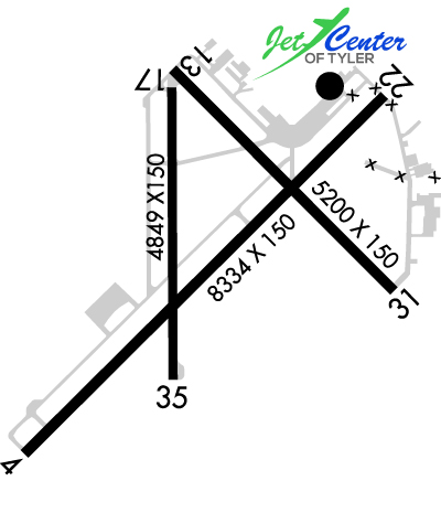
| Lat: N 3221.2 Long: W 09524.2 Elev: 544 Var: -03 Longest Runway: 8334 | ||
| Dept. ATIS: 126.25 Arr. ATIS: 126.25 Ground: 121.9 Tower: 120.1 | ||
| |||||||||||||||||||||||||||||||||||||||||||||||||||||||||||||||||||||
| |||||||||||||||||||||||||||||||||||||||||||||||||||||||||||||||||||||
| |||||||||||||||||||||||||||||||||||||||||||||||||||||||||||||||||||||
| |||||||||||||||||||||||||||||||||||||||||||||||||||||||||||||||||||||
| Rwy | Rwy | |||||||
| 8334x150 | 8334' | 111.95 - 042° | 8334x150 | 7734' | ||||
| 5198x150 | 5198' | 5198x150 | 5198' | |||||
| 4832x150 | 4832' | 4832x150 | 4832' | |||||
| Runway ID | Single Wheel | Double Wheel | Double Tandem Wheel | Dual Double Wheel |
| 04/22 | 120,000 | 222,000 | 357,000 | N/A |
| 13/31 | 25,000 | 40,000 | N/A | N/A |
| 18/36 | 109,000 | 172,000 | 289,000 | N/A |
| These numbers are Advisory and are not limits. The Airport Manager should have more accurate Weight Limits | ||||
 Airport Diagram might not be current. | |
| Facility Name: | TYLER POUNDS RGNL |
| City Name: | TYLER |
| County: | SMITH |
| State abbrev: | TX |
| State Name: | TEXAS |
| Ownership: | PUBLICLY OWNED |
| Use: | OPEN TO THE PUBLIC |
| Owner's Name: | CITY OF TYLER |
| Address: | PO BOX 2039 |
| TYLER, TX 75710 | |
| Owner's Phone: | 903-531-9825 |
| Manager's Name: | STEVE M. THOMPSON |
| Address: | 700 SKYWAY BLVD, SUITE 201 |
| TYLER, TX 75704 | |
| Phone: | 903-531-2343 |
| FAA Region: | SOUTHWEST |
| FAA Field Office: | TEX |
| Date | Sunrise | Sunset |
|---|---|---|
| 03/24/26 Tuesday | 7:21 | 19:36 |
| 03/25/26 Wednesday | 7:19 | 19:37 |
| 03/26/26 Thursday | 7:18 | 19:37 |
| 03/27/26 Friday | 7:17 | 19:38 |
| 03/28/26 Saturday | 7:15 | 19:39 |
| 03/29/26 Sunday | 7:14 | 19:39 |
| 03/30/26 Monday | 7:13 | 19:40 |
| 03/31/26 Tuesday | 7:11 | 19:41 |
| 04/01/26 Wednesday | 7:10 | 19:41 |
| 04/02/26 Thursday | 7:09 | 19:42 |
| 04/03/26 Friday | 7:08 | 19:43 |
| 04/04/26 Saturday | 7:06 | 19:44 |
| 04/05/26 Sunday | 7:05 | 19:44 |
| 04/06/26 Monday | 7:04 | 19:45 |
| Airport Attendance Schedule | 7 Days A Week 0500-2200 |
| Airport Status | OPERATIONAL (This Status can change at any time - please check NOTAMS) |
| Airport Lighting Schedule | WHEN ATCT CLSD ACTVT MALSR RWY 04; REIL RWY 22; HIRL RWY 04/22; MIRL RWY 18/36; TWY LGTS - CTAF. HIRL RWY 13/31 PRESET MED INTST, TO INCR INTST ACTVT - CTAF. PAPI RWYS 04 & 22, VASI RWY 31 OPR CONSLY. |
| Airport Storage Available | Tie Downs, Hanger |
| Extra Services Available | Air Freight, Cargo Handling, Charter, Flight Instruction, Aircraft Rental, Aircraft Sales, Annual Surveying |
| Wind Indicator | YES - (lighted) |
| Control Tower | YES |
| CTAF Frequency | 120.100 |
| Unicom Frequency | 122.950 |
| Rotating Beacon Color | WG |
| Segmented Circle | YES |
| Landing Fee | NO |
| Airport Inspected | FEDERAL - performed by FAA AIRPORTS FIELD PERSONNEL |
| Inspection Date | 03/28/2025 |
| Type of Fuel Available | Grade 100LL, JET A (freeze point -40C) |
| Airframe Repair Service | MAJOR |
| Power Plant Repair Service | MAJOR |
| Latitude | N3221.2 |
| Longitude | W09524.2 (ESTIMATED) |
| Arpt Elevation | 543ft (SURVEYED) |
| Magnetic Variation | 03E |
| 3 miles W | of TYLER |
| Traffic Pattern Altitude | |
| Sectional Chart | DALLAS-FT WORTH |
| Operations (Reported) | Yearly | Avg. Daily |
|---|---|---|
| General Aviation Transient | 0 | 0 |
| General Aviation Local | 0 | 0 |
| Air Taxi | 0 | 0 |
| Commerical | 0 | 0 |
| Commuter | 0 | 0 |
| Military | 0 | 0 |
| Aircraft based on Field | |
|---|---|
| General Aviation Singles | 0 |
| General Aviation Multi | 0 |
| Jet Aircraft | 0 |
| General Aviation Helicopters | 0 |
| Military Aircraft | 0 |
| Gliders | 0 |
| Ultralights | 0 |
| FSS on field | NO |
| FSS tie-in | FORT WORTH |
| FSS Phone | 1-800-WX-BRIEF |
| Who issues Notams | TYR |
| Notam D service at airport | YES |
| ARTCC Name | FORT WORTH |
| Airport Certification | AIRPORT RECEIVING SCHEDULED AIR CARRIER SERVICE FROM CARRIERS CERTIFICATED BY THE CIVIL AERONAUTICS BOARD |
| Aircraft Rescue & Firefighting Index | AIRPORT HAS A CERTIFICATE UNDER CFR PART 139 |
| Airport of Entry | No |
| Custom Landing Rights | No |
| Joint Civil/Military | No |
| Military Landing rights | YES |
| NATIONAL PLAN OF INTEGRATED AIRPORT SYSTEMS (NPIAS) |
| GRANT AGREEMENTS UNDER FAAP/ADAP/AIP |
| ASSURANCES PURSUANT TO TITLE VI, CIVIL RIGHTS ACT OF 1964 |
| AGREEMENT UNDER DLAND OR DCLA HAS EXPIRED. |
| HELICOPTERS OPERATING INBOUND OR OUTBOUND TO/FROM THE DOWNTOWN HOSPITALS STATE INTENTION ON 123.075. |
| WEST SIDE PSGR TERMINAL RAMP ACCESS RSTD TO ACR. |
| NOISE ABATEMENT PROCEDURES IN EFFECT CALL 903-590-3048. |
| CONDS NOT MNTD BTN THE HRS OF 9:30 PM AND 6:30 AM LOCAL. |
| FOR CD IF UNA TO CTC ON FSS FREQ, CTC FORT WORTH ARTCC AT 817-858-7584. |
| RWY 04/2 2 PCR VALUE: 640/R/B/W/T |
| RWY 13/3 1 PCR VALUE: 150/F/D/X/T |
| RWY 18/3 6 PCR VALUE: 670/F/C/X/T |
Airport Communications & Frequencies:
| |||||||||||||||||||||||||||||
| Runway: 04 | Runway: 22 | ||
| Mag heading: | 42° | Mag heading: | 222° |
| Rwy Slope: | -.13% Down | Rwy Slope: | .13% Up |
| Approach: | ILS/DME | Approach: | |
| Pattern: | Left Traffic | Pattern: | Left Traffic |
| Markings: | PRECISION INSTRUMENT | Markings: | PRECISION INSTRUMENT |
| Marking Condition: | GOOD | Marking Condition: | GOOD |
| Arresting Dev: | Arresting Dev: | ||
| Lat & Long: | N3220.6 W09524.8 | Lat. & Long.: | N3221.6 W09523.7 |
| Elev: | 540.3 ft. MSL | Elev: | 529.5 ft. MSL |
| TCH: | 55 ft. AGL | TCH: | 54 ft. AGL |
| Visual Glide Path: | 3.00 degrees | Visual Glide Path: | 3.00 degrees |
| Displaced Threshold: | No | Displaced Threshold: | 600 feet |
| Touchdown Zone: | YES | Touchdown Zone: | YES |
| Touchdown Elev.: | 542.3 feet | Touchdown Elev.: | 539.1 feet |
| Visual Glide Slope: | 4-Light PAPI on LEFT side of Runway | Visual Glide Slope: | 4-Light PAPI on LEFT side of Runway; UNUSBL BYD 9 DEG LEFT AND RIGHT OF RWY CNTRLN. |
| RVR Equipment: | RVR Equipment: | ||
| RVV Equipment: | NO | RVV Equipment: | NO |
| Approach Lights: | MALSR - 1,400 foot medium intensity approach lighting system with runway alignment indicator lights | Approach Lights: | |
| REIL: | NO | REIL: | YES |
| Centerline Lights: | NO | Centerline Lights: | NO |
| Touchdown lights: | NO | Touchdown lights: | NO |
| Runway Category: | Precision Instrument Runway | Runway Category: | Runway with a Non-precision Approach having visibility minimums greater than 3/4 mile |
| Declared Distances: | TORA:8334' TODA:8334' ASDA:7734' LDA:7734' | Declared Distances: | TORA:8334' TODA:8334' ASDA:8334' LDA:7734' |
| Obstructions: | Obstructions: | TREE | |
| Marked: | Marked: | NOT Marked/Lighted | |
| Clearance slope: | 50:1 | Clearance slope: | 33:1 |
| Obstruction height: | Obstruction height: | 28 feet AGL | |
| Dist. from runway: | Dist. from runway: | 1146 feet | |
| Centerline offset: | Centerline offset: | 80 feet right of centerline | |
| Comments: | Comments: |
| Runway: 13 | Runway: 31 | ||
| Mag heading: | 132° | Mag heading: | 312° |
| Rwy Slope: | .52% Up | Rwy Slope: | -.52% Down |
| Approach: | Approach: | ||
| Pattern: | Left Traffic | Pattern: | Left Traffic |
| Markings: | PRECISION INSTRUMENT | Markings: | PRECISION INSTRUMENT |
| Marking Condition: | GOOD | Marking Condition: | GOOD |
| Arresting Dev: | Arresting Dev: | ||
| Lat & Long: | N3221.7 W09524.3 | Lat. & Long.: | N3221.1 W09523.6 |
| Elev: | 515.4 ft. MSL | Elev: | 542.3 ft. MSL |
| TCH: | TCH: | 54 ft. AGL | |
| Visual Glide Path: | Visual Glide Path: | 3.00 degrees | |
| Displaced Threshold: | No | Displaced Threshold: | No |
| Touchdown Zone: | YES | Touchdown Zone: | YES |
| Touchdown Elev.: | 538.9 feet | Touchdown Elev.: | 543.9 feet |
| Visual Glide Slope: | Visual Glide Slope: | 4-BOX VASI ON LEFT SIDE OF RUNWAY | |
| RVR Equipment: | RVR Equipment: | ||
| RVV Equipment: | NO | RVV Equipment: | NO |
| Approach Lights: | Approach Lights: | ||
| REIL: | NO | REIL: | NO |
| Centerline Lights: | NO | Centerline Lights: | NO |
| Touchdown lights: | NO | Touchdown lights: | NO |
| Runway Category: | Runway with a Non-precision Approach having visibility minimums greater than 3/4 mile | Runway Category: | Runway with a Non-precision Approach having visibility minimums greater than 3/4 mile |
| Declared Distances: | TORA:5198' TODA:5198' ASDA:5198' LDA:5198' | Declared Distances: | TORA:5198' TODA:5198' ASDA:5198' LDA:5198' |
| Obstructions: | POLE | Obstructions: | ROAD |
| Marked: | NOT Marked/Lighted | Marked: | NOT Marked/Lighted |
| Clearance slope: | 49:1 | Clearance slope: | 28:1 |
| Obstruction height: | 28 feet AGL | Obstruction height: | 14 feet AGL |
| Dist. from runway: | 1550 feet | Dist. from runway: | 600 feet |
| Centerline offset: | 550 right of centerline | Centerline offset: | 520 feet right of centerline |
| Comments: | Comments: |
| Runway: 18 | Runway: 36 | ||
| Mag heading: | 177° | Mag heading: | 357° |
| Rwy Slope: | .55% Up | Rwy Slope: | -.55% Down |
| Approach: | Approach: | ||
| Pattern: | Left Traffic | Pattern: | Left Traffic |
| Markings: | NONPRECISION INSTRUMENT | Markings: | NONPRECISION INSTRUMENT |
| Marking Condition: | GOOD | Marking Condition: | GOOD |
| Arresting Dev: | Arresting Dev: | ||
| Lat & Long: | N3221.6 W09524.3 | Lat. & Long.: | N3220.8 W09524.3 |
| Elev: | 517.0 ft. MSL | Elev: | 543.6 ft. MSL |
| TCH: | TCH: | ||
| Visual Glide Path: | Visual Glide Path: | ||
| Displaced Threshold: | No | Displaced Threshold: | No |
| Touchdown Zone: | YES | Touchdown Zone: | YES |
| Touchdown Elev.: | 538.3 feet | Touchdown Elev.: | 543.9 feet |
| Visual Glide Slope: | Visual Glide Slope: | ||
| RVR Equipment: | RVR Equipment: | ||
| RVV Equipment: | NO | RVV Equipment: | NO |
| Approach Lights: | Approach Lights: | ||
| REIL: | NO | REIL: | NO |
| Centerline Lights: | NO | Centerline Lights: | NO |
| Touchdown lights: | NO | Touchdown lights: | NO |
| Runway Category: | Runway with a Visual Approach | Runway Category: | Runway with a Visual Approach |
| Declared Distances: | TORA:4832' TODA:4832' ASDA:4832' LDA:4832' | Declared Distances: | TORA:4832' TODA:4832' ASDA:4832' LDA:4832' |
| Obstructions: | TREE | Obstructions: | TREE |
| Marked: | NOT Marked/Lighted | Marked: | NOT Marked/Lighted |
| Clearance slope: | 23:1 | Clearance slope: | 30:1 |
| Obstruction height: | 38 feet AGL | Obstruction height: | 43 feet AGL |
| Dist. from runway: | 1100 feet | Dist. from runway: | 1158 feet |
| Centerline offset: | 13 left of centerline | Centerline offset: | 239 feet left of centerline |
| Comments: | Comments: |
Thanks for using FltPlan.com
all rights reserved © 1999-2026 by Flight Plan LLC