
| JACQUELINE COCHRAN RGNL PALM SPRINGS CA |
| |
| Lat: N 3337.6 Long: W 11609.6 Elev: -114 Var: -13 Longest Runway: 8500 | ||
| Clr Del: 120.225 AWOS: 118.32 CTAF: 123.0 | ||
| |||||||||||||||||||||||||||||||||||||||||||||||||||||||||||||||||||||
| |||||||||||||||||||||||||||||||||||||||||||||||||||||||||||||||||||||
| |||||||||||||||||||||||||||||||||||||||||||||||||||||||||||||||||||||
| |||||||||||||||||||||||||||||||||||||||||||||||||||||||||||||||||||||
| |||||||||||||||||||||||||||||||||||||||||||||||||||||||||||||||||||||
| Rwy | Rwy | |||||||
| 4995x100 | 4995' | 4995x100 | 4995' | |||||
| 8500x150 | 8500' | 8500x150 | 8500' | |||||
| Runway ID | Single Wheel | Double Wheel | Double Tandem Wheel | Dual Double Wheel |
| 12/30 | 20,000 | 60,000 | N/A | N/A |
| 17/35 | 75,000 | 200,000 | 325,000 | 850,000 |
| These numbers are Advisory and are not limits. The Airport Manager should have more accurate Weight Limits | ||||
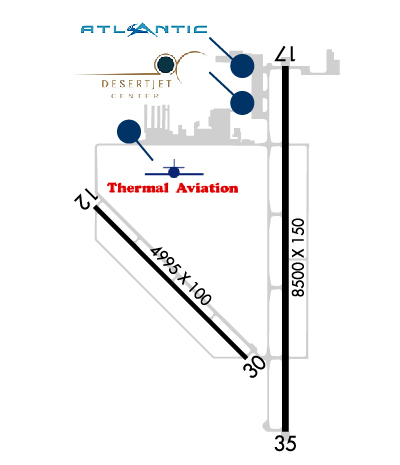 Airport Diagram might not be current. | |
| Facility Name: | JACQUELINE COCHRAN RGNL |
| City Name: | PALM SPRINGS |
| County: | RIVERSIDE |
| State abbrev: | CA |
| State Name: | CALIFORNIA |
| Ownership: | PUBLICLY OWNED |
| Use: | OPEN TO THE PUBLIC |
| Owner's Name: | COUNTY OF RIVERSIDE |
| Address: | 4080 LEMON STREET, 14TH FLOOR |
| RIVERSIDE, CA 92501 | |
| Owner's Phone: | 951-955-9722 |
| Manager's Name: | ANGELA JAMISON |
| Address: | 4080 LEMON STREET, 14TH FLOOR |
| RIVERSIDE, CA 92501 | |
| Phone: | 951-955-9418 |
| FAA Region: | WESTERN-PACIFIC |
| FAA Field Office: | LAX |
| Date | Sunrise | Sunset |
|---|---|---|
| 04/26/26 Sunday | 6:02 | 19:24 |
| 04/27/26 Monday | 6:00 | 19:25 |
| 04/28/26 Tuesday | 5:59 | 19:25 |
| 04/29/26 Wednesday | 5:58 | 19:26 |
| 04/30/26 Thursday | 5:57 | 19:27 |
| 05/01/26 Friday | 5:56 | 19:28 |
| 05/02/26 Saturday | 5:55 | 19:28 |
| 05/03/26 Sunday | 5:54 | 19:29 |
| 05/04/26 Monday | 5:53 | 19:30 |
| 05/05/26 Tuesday | 5:52 | 19:31 |
| 05/06/26 Wednesday | 5:51 | 19:32 |
| 05/07/26 Thursday | 5:51 | 19:32 |
| 05/08/26 Friday | 5:50 | 19:33 |
| 05/09/26 Saturday | 5:49 | 19:34 |
| Airport Attendance Schedule | 7 Days A Week 0700-1800 |
| Airport Status | OPERATIONAL (This Status can change at any time - please check NOTAMS) |
| Airport Lighting Schedule | ACTVT REIL RWYS 17 & 35; PAPI RWYS 12, 17, 30 & 35; MIRL RWYS 12/30 & 17/35 - CTAF. |
| Airport Storage Available | Tie Downs, Hanger |
| Extra Services Available | Air Ambulance, Charter |
| Wind Indicator | YES - (lighted) |
| Control Tower | NO |
| CTAF Frequency | 123.000 |
| Unicom Frequency | 123.000 |
| Rotating Beacon Color | WG |
| Segmented Circle | YES |
| Landing Fee | NO |
| Airport Inspected | STATE - performed by STATE AERONAUTICAL PERSONNEL |
| Inspection Date | 11/04/2025 |
| Type of Fuel Available | Grade 100LL, JET A (freeze point -40C) |
| Airframe Repair Service | MAJOR |
| Power Plant Repair Service | MAJOR |
| Latitude | N3337.6 |
| Longitude | W11609.6 (ESTIMATED) |
| Arpt Elevation | -115ft (SURVEYED) |
| Magnetic Variation | 13E |
| 20 miles SE | of PALM SPRINGS |
| Traffic Pattern Altitude | |
| Sectional Chart | LOS ANGELES |
| Operations (Reported) | Yearly | Avg. Daily |
|---|---|---|
| General Aviation Transient | 0 | 0 |
| General Aviation Local | 0 | 0 |
| Air Taxi | 0 | 0 |
| Commerical | 0 | 0 |
| Commuter | 0 | 0 |
| Military | 0 | 0 |
| Aircraft based on Field | |
|---|---|
| General Aviation Singles | 0 |
| General Aviation Multi | 0 |
| Jet Aircraft | 0 |
| General Aviation Helicopters | 0 |
| Military Aircraft | 0 |
| Gliders | 0 |
| Ultralights | 0 |
| FSS on field | NO |
| FSS tie-in | RIVERSIDE |
| FSS Phone | 1-800-WX-BRIEF |
| Who issues Notams | TRM |
| Notam D service at airport | YES |
| ARTCC Name | LOS ANGELES |
| Airport Certification | |
| Aircraft Rescue & Firefighting Index | None |
| Airport of Entry | No |
| Custom Landing Rights | No |
| Joint Civil/Military | No |
| Military Landing rights | YES |
| NATIONAL PLAN OF INTEGRATED AIRPORT SYSTEMS (NPIAS) |
| GRANT AGREEMENTS UNDER FAAP/ADAP/AIP |
| SURPLUS PROPERTY AGREEMENT UNDER PUBLIC LAW 289 |
| ASSURANCES PURSUANT TO TITLE VI, CIVIL RIGHTS ACT OF 1964 |
| SOFT GND OFF RWY PAVEMENT. |
| FOR CD CTC SOCAL APCH AT 800-448-3724. |
| RWY 17/3 5 200 FT BLAST PADS BOTH ENDS. |
Airport Communications & Frequencies:
| |||||||||||||||||||
| Runway: 12 | Runway: 30 | ||
| Mag heading: | 122° | Mag heading: | 302° |
| Rwy Slope: | -.31% Down | Rwy Slope: | .31% Up |
| Approach: | Approach: | ||
| Pattern: | Left Traffic | Pattern: | Left Traffic |
| Markings: | BASIC | Markings: | NONPRECISION INSTRUMENT |
| Marking Condition: | GOOD | Marking Condition: | GOOD |
| Arresting Dev: | Arresting Dev: | ||
| Lat & Long: | N3337.8 W11610.3 | Lat. & Long.: | N3337.2 W11609.6 |
| Elev: | -115.0 ft. MSL | Elev: | -130.3 ft. MSL |
| TCH: | 25 ft. AGL | TCH: | 25 ft. AGL |
| Visual Glide Path: | 3.00 degrees | Visual Glide Path: | 3.00 degrees |
| Displaced Threshold: | No | Displaced Threshold: | No |
| Touchdown Zone: | YES | Touchdown Zone: | YES |
| Touchdown Elev.: | -115.0 feet | Touchdown Elev.: | -120.4 feet |
| Visual Glide Slope: | 2-Light PAPI on LEFT side of Runway | Visual Glide Slope: | 2-Light PAPI on LEFT side of Runway |
| RVR Equipment: | RVR Equipment: | ||
| RVV Equipment: | NO | RVV Equipment: | NO |
| Approach Lights: | Approach Lights: | ||
| REIL: | NO | REIL: | NO |
| Centerline Lights: | NO | Centerline Lights: | NO |
| Touchdown lights: | NO | Touchdown lights: | NO |
| Runway Category: | Runway with a Visual Approach | Runway Category: | Runway with a Non-precision Approach having visibility minimums greater than 3/4 mile |
| Declared Distances: | Declared Distances: |
| Runway: 17 | Runway: 35 | ||
| Mag heading: | 167° | Mag heading: | 347° |
| Rwy Slope: | -.24% Down | Rwy Slope: | .24% Up |
| Approach: | Approach: | ||
| Pattern: | Left Traffic | Pattern: | Left Traffic |
| Markings: | BASIC | Markings: | NONPRECISION INSTRUMENT |
| Marking Condition: | GOOD | Marking Condition: | GOOD |
| Arresting Dev: | Arresting Dev: | ||
| Lat & Long: | N3338.3 W11609.4 | Lat. & Long.: | N3336.9 W11609.4 |
| Elev: | -114.4 ft. MSL | Elev: | -134.4 ft. MSL |
| TCH: | 51 ft. AGL | TCH: | 52 ft. AGL |
| Visual Glide Path: | 3.00 degrees | Visual Glide Path: | 3.00 degrees |
| Displaced Threshold: | No | Displaced Threshold: | No |
| Touchdown Zone: | YES | Touchdown Zone: | YES |
| Touchdown Elev.: | -114.4 feet | Touchdown Elev.: | -127.8 feet |
| Visual Glide Slope: | 4-Light PAPI on LEFT side of Runway | Visual Glide Slope: | 4-Light PAPI on LEFT side of Runway; UNUSBL BYD 8 NM DUE TO TERRAIN. |
| RVR Equipment: | RVR Equipment: | ||
| RVV Equipment: | NO | RVV Equipment: | NO |
| Approach Lights: | Approach Lights: | ||
| REIL: | YES | REIL: | YES |
| Centerline Lights: | NO | Centerline Lights: | NO |
| Touchdown lights: | NO | Touchdown lights: | NO |
| Runway Category: | Runway with a Visual Approach | Runway Category: | Runway with a Non-precision Approach having visibility minimums greater than 3/4 mile |
| Declared Distances: | Declared Distances: |
Thanks for using FltPlan.com
all rights reserved © 1999-2026 by Flight Plan LLC