| STATESBORO-BULLOCH COUNTY STATESBORO GA |
| |
| Lat: N 3229.0 Long: W 08144.2 Elev: 187 Var: +05 Longest Runway: 6000 | ||
| AWOS: 119.02 CTAF: 122.72 | ||
| |||||||||||||||||||||||||||||||||||||||||||||||||||||||||||||||||||||
| |||||||||||||||||||||||||||||||||||||||||||||||||||||||||||||||||||||
| |||||||||||||||||||||||||||||||||||||||||||||||||||||||||||||||||||||
| Rwy | Rwy | |||||||
| 4382x100 | 4382' | 4382x100 | 4382' | |||||
| 6000x100 | 6000' | 6000x100 | 5701' | 111.50 - 320° | ||||
| Runway ID | Single Wheel | Double Wheel | Double Tandem Wheel | Dual Double Wheel |
| 06/24 | 73,000 | 105,000 | 172,000 | N/A |
| 14/32 | 120,000 | 211,000 | 358,000 | 851,000 |
| These numbers are Advisory and are not limits. The Airport Manager should have more accurate Weight Limits | ||||
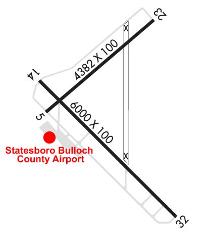 Airport Diagram might not be current. | |
| Facility Name: | STATESBORO-BULLOCH COUNTY |
| City Name: | STATESBORO |
| County: | BULLOCH |
| State abbrev: | GA |
| State Name: | GEORGIA |
| Ownership: | PUBLICLY OWNED |
| Use: | OPEN TO THE PUBLIC |
| Owner's Name: | STATESBORO CITY & BULLOCH COUNTY |
| Address: | 115 NORTH MAIN STREET |
| STATESBORO, GA 30458 | |
| Owner's Phone: | 912-764-5468 |
| Manager's Name: | KATHY BOYKIN |
| Address: | 601 AIRPORT BLVD |
| STATESBORO, GA 30461 | |
| Phone: | 912-764-9083 |
| FAA Region: | SOUTHERN |
| FAA Field Office: | ATL |

| Date | Sunrise | Sunset |
|---|---|---|
| 06/12/26 Friday | 6:19 | 20:35 |
| 06/13/26 Saturday | 6:19 | 20:35 |
| 06/14/26 Sunday | 6:19 | 20:35 |
| 06/15/26 Monday | 6:19 | 20:36 |
| 06/16/26 Tuesday | 6:19 | 20:36 |
| 06/17/26 Wednesday | 6:19 | 20:36 |
| 06/18/26 Thursday | 6:19 | 20:37 |
| 06/19/26 Friday | 6:20 | 20:37 |
| 06/20/26 Saturday | 6:20 | 20:37 |
| 06/21/26 Sunday | 6:20 | 20:37 |
| 06/22/26 Monday | 6:20 | 20:38 |
| 06/23/26 Tuesday | 6:20 | 20:38 |
| 06/24/26 Wednesday | 6:21 | 20:38 |
| 06/25/26 Thursday | 6:21 | 20:38 |
| Airport Attendance Schedule | MON-FRI 0800-1900, SAT-SUN 0900-1700 |
| Airport Status | OPERATIONAL (This Status can change at any time - please check NOTAMS) |
| Airport Lighting Schedule | HIRL RWY 14/32 PRESET ON MED INTST DUSK-2300; TO INCR INTST & ACTVT HIRL AFTER 2300 - CTAF. ACTVT MALSR RWY 32; PAPI RWY 14 & 32 - CTAF. |
| Airport Storage Available | Tie Downs |
| Extra Services Available | Flight Instruction, Aircraft Rental |
| Wind Indicator | YES - (lighted) |
| Control Tower | NO |
| CTAF Frequency | 122.725 |
| Unicom Frequency | 122.725 |
| Rotating Beacon Color | WG |
| Segmented Circle | YES |
| Landing Fee | NO |
| Airport Inspected | STATE - performed by STATE AERONAUTICAL PERSONNEL |
| Inspection Date | 04/04/2025 |
| Type of Fuel Available | Grade 100LL, JET A; -1024 HR SELF-SERVE FUEL AVBL. |
| Airframe Repair Service | MAJOR |
| Power Plant Repair Service | MAJOR |
| Latitude | N3229.0 |
| Longitude | W08144.2 (ESTIMATED) |
| Arpt Elevation | 186ft (SURVEYED) |
| Magnetic Variation | 05W |
| 3 miles NE | of STATESBORO |
| Traffic Pattern Altitude | |
| Sectional Chart | ATLANTA |
| Operations (Reported) | Yearly | Avg. Daily |
|---|---|---|
| General Aviation Transient | 0 | 0 |
| General Aviation Local | 0 | 0 |
| Air Taxi | 0 | 0 |
| Commerical | 0 | 0 |
| Commuter | 0 | 0 |
| Military | 0 | 0 |
| Aircraft based on Field | |
|---|---|
| General Aviation Singles | 0 |
| General Aviation Multi | 0 |
| Jet Aircraft | 0 |
| General Aviation Helicopters | 0 |
| Military Aircraft | 0 |
| Gliders | 0 |
| Ultralights | 0 |
| FSS on field | NO |
| FSS tie-in | MACON |
| FSS Phone | 1-800-WX-BRIEF |
| Who issues Notams | TBR |
| Notam D service at airport | YES |
| ARTCC Name | JACKSONVILLE |
| Airport Certification | |
| Aircraft Rescue & Firefighting Index | None |
| Airport of Entry | No |
| Custom Landing Rights | No |
| Joint Civil/Military | No |
| Military Landing rights | YES |
| NATIONAL PLAN OF INTEGRATED AIRPORT SYSTEMS (NPIAS) |
| GRANT AGREEMENTS UNDER FAAP/ADAP/AIP |
| SURPLUS PROPERTY AGREEMENT UNDER REGULATION 16-WAA |
| ASSURANCES PURSUANT TO TITLE VI, CIVIL RIGHTS ACT OF 1964 |
| AGREEMENT UNDER DLAND OR DCLA HAS EXPIRED. |
| THIS AIRPORT HAS BEEN SURVEYED BY THE NATIONAL GEODETIC SURVEY. |
| BIRDS & DEER ON & INVOF ARPT. |
| FOR CD CTC SAVANNAH APCH AT 912-964-3205, WHEN APCH CLSD CTC JACKSONVILLE ARTCC AT 904-845-1592. |
| RWY 06/2 4 PCR VALUE: 285/F/C/X/T |
| RWY 14/3 2 PCR VALUE: 522/F/B/X/T |
Airport Communications & Frequencies:
| |||||||||||||||||
| Runway: 06 | Runway: 24 | ||
| Mag heading: | 55° | Mag heading: | 235° |
| Rwy Slope: | .20% Up | Rwy Slope: | -.20% Down |
| Approach: | Approach: | ||
| Pattern: | Left Traffic | Pattern: | Left Traffic |
| Markings: | BASIC | Markings: | BASIC |
| Marking Condition: | GOOD | Marking Condition: | GOOD |
| Arresting Dev: | Arresting Dev: | ||
| Lat & Long: | N3229.0 W08144.6 | Lat. & Long.: | N3229.4 W08143.9 |
| Elev: | 177.8 ft. MSL | Elev: | 186.7 ft. MSL |
| TCH: | TCH: | ||
| Visual Glide Path: | Visual Glide Path: | ||
| Displaced Threshold: | No | Displaced Threshold: | No |
| Touchdown Zone: | YES | Touchdown Zone: | YES |
| Touchdown Elev.: | 180.8 feet | Touchdown Elev.: | 186.7 feet |
| Visual Glide Slope: | Visual Glide Slope: | ||
| RVR Equipment: | RVR Equipment: | ||
| RVV Equipment: | NO | RVV Equipment: | NO |
| Approach Lights: | Approach Lights: | ||
| REIL: | NO | REIL: | NO |
| Centerline Lights: | NO | Centerline Lights: | NO |
| Touchdown lights: | NO | Touchdown lights: | NO |
| Runway Category: | Runway with a Visual Approach | Runway Category: | Runway with a Visual Approach |
| Declared Distances: | Declared Distances: | ||
| Obstructions: | TREES | Obstructions: | TREES |
| Marked: | NOT Marked/Lighted | Marked: | NOT Marked/Lighted |
| Clearance slope: | 19:1 | Clearance slope: | 12:1 |
| Obstruction height: | 78 feet AGL | Obstruction height: | 72 feet AGL |
| Dist. from runway: | 1729 feet | Dist. from runway: | 1126 feet |
| Centerline offset: | 385 left of centerline | Centerline offset: | 300 feet right of centerline |
| Comments: | Comments: |
| Runway: 14 | Runway: 32 | ||
| Mag heading: | 140° | Mag heading: | 320° |
| Rwy Slope: | -.39% Down | Rwy Slope: | .39% Up |
| Approach: | Approach: | ILS | |
| Pattern: | Left Traffic | Pattern: | Left Traffic |
| Markings: | PRECISION INSTRUMENT | Markings: | PRECISION INSTRUMENT |
| Marking Condition: | GOOD | Marking Condition: | GOOD |
| Arresting Dev: | Arresting Dev: | ||
| Lat & Long: | N3229.1 W08144.6 | Lat. & Long.: | N3228.4 W08143.8 |
| Elev: | 180.8 ft. MSL | Elev: | 157.2 ft. MSL |
| TCH: | 42 ft. AGL | TCH: | 47 ft. AGL |
| Visual Glide Path: | 4.00 degrees | Visual Glide Path: | 3.00 degrees |
| Displaced Threshold: | No | Displaced Threshold: | 299 feet |
| Touchdown Zone: | YES | Touchdown Zone: | YES |
| Touchdown Elev.: | 180.9 feet | Touchdown Elev.: | 178.7 feet |
| Visual Glide Slope: | 2-Light PAPI on LEFT side of Runway | Visual Glide Slope: | 2-Light PAPI on LEFT side of Runway |
| RVR Equipment: | RVR Equipment: | ||
| RVV Equipment: | NO | RVV Equipment: | NO |
| Approach Lights: | Approach Lights: | MALSR - 1,400 foot medium intensity approach lighting system with runway alignment indicator lights | |
| REIL: | NO | REIL: | NO |
| Centerline Lights: | NO | Centerline Lights: | NO |
| Touchdown lights: | NO | Touchdown lights: | NO |
| Runway Category: | Runway with a Non-precision Approach having visibility minimums greater than 3/4 mile | Runway Category: | Precision Instrument Runway |
| Declared Distances: | TORA:6000' TODA:6000' ASDA:6000' LDA:6000' | Declared Distances: | TORA:6000' TODA:6000' ASDA:6000' LDA:5701' |
| Obstructions: | TREES | Obstructions: | ROAD |
| Marked: | NOT Marked/Lighted | Marked: | NOT Marked/Lighted |
| Clearance slope: | 22:1 | Clearance slope: | 12:1; APPROACH SLOPE TO DSPLCD THLD IS 30:1; TREES 570FT FROM DSPLCD THLD 288FT LEFT. |
| Obstruction height: | 72 feet AGL | Obstruction height: | 15 feet AGL |
| Dist. from runway: | 1793 feet | Dist. from runway: | 380 feet |
| Centerline offset: | 637 left of centerline | Centerline offset: | 540 feet right of centerline |
| Comments: | Comments: |
Thanks for using FltPlan.com
all rights reserved © 1999-2026 by Flight Plan LLC