
| NORMAN Y. MINETA SAN JOSE INTL SAN JOSE CA |
| |
| Lat: N 3721.8 Long: W 12155.7 Elev: 62 Var: -13 Longest Runway: 11000 | ||
| Clr Del: 118.0 Dept. ATIS: 126.95 Arr. ATIS: 126.95 Ground: 121.7 Tower: 124.0 | ||
| ||||||||||||||||||||||||||||||||||||||||||||||||||||||||||||||||||||
| ||||||||||||||||||||||||||||||||||||||||||||||||||||||||||||||||||||
| ||||||||||||||||||||||||||||||||||||||||||||||||||||||||||||||||||||
| ||||||||||||||||||||||||||||||||||||||||||||||||||||||||||||||||||||
| ||||||||||||||||||||||||||||||||||||||||||||||||||||||||||||||||||||
| ||||||||||||||||||||||||||||||||||||||||||||||||||||||||||||||||||||
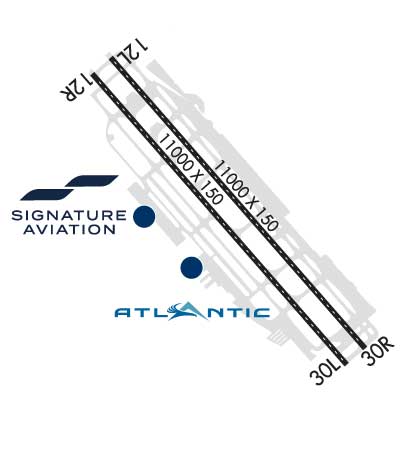
| Rwy | Rwy | |||||||
| 11000x150 | 9693' | 11000x150 | 8463' | |||||
| 11000x150 | 9703' | 110.90 - 125° | 11000x150 | 8463' | 110.90 - 305° | |||
| Runway ID | Single Wheel | Double Wheel | Double Tandem Wheel | Dual Double Wheel |
| 12L/30R | 120,000 | 250,000 | 550,000 | 1,116,000 |
| 12R/30L | 120,000 | 250,000 | 550,000 | 1,120,000 |
| These numbers are Advisory and are not limits. The Airport Manager should have more accurate Weight Limits | ||||
 Airport Diagram might not be current. | |
| Facility Name: | NORMAN Y MINETA SAN JOSE INTL |
| City Name: | SAN JOSE |
| County: | SANTA CLARA |
| State abbrev: | CA |
| State Name: | CALIFORNIA |
| Ownership: | PUBLICLY OWNED |
| Use: | OPEN TO THE PUBLIC |
| Owner's Name: | CITY OF SAN JOSE |
| Address: | 200 E. SANTA CLARA STREET |
| SAN JOSE, CA 95113 | |
| Owner's Phone: | 408-277-5100 |
| Manager's Name: | MUKESH (MOOKIE) PATEL |
| Address: | 1701 AIRPORT BLVD., SUITE B-1130 |
| SAN JOSE, CA 95110-1206 | |
| Phone: | (408) 277-5100 |
| FAA Region: | WESTERN-PACIFIC |
| FAA Field Office: | SFO |

| Date | Sunrise | Sunset |
|---|---|---|
| 07/13/26 Monday | 5:57 | 20:29 |
| 07/14/26 Tuesday | 5:58 | 20:29 |
| 07/15/26 Wednesday | 5:59 | 20:28 |
| 07/16/26 Thursday | 5:59 | 20:28 |
| 07/17/26 Friday | 6:00 | 20:27 |
| 07/18/26 Saturday | 6:01 | 20:27 |
| 07/19/26 Sunday | 6:02 | 20:26 |
| 07/20/26 Monday | 6:02 | 20:25 |
| 07/21/26 Tuesday | 6:03 | 20:25 |
| 07/22/26 Wednesday | 6:04 | 20:24 |
| 07/23/26 Thursday | 6:05 | 20:23 |
| 07/24/26 Friday | 6:05 | 20:22 |
| 07/25/26 Saturday | 6:06 | 20:22 |
| 07/26/26 Sunday | 6:07 | 20:21 |
| Airport Attendance Schedule | CONTINUOUS |
| Airport Status | OPERATIONAL (This Status can change at any time - please check NOTAMS) |
| Airport Lighting Schedule | ACTVT MALSR RWY 12R, MALSR RWY 30L, HIRL RWY 12L/30R, HIRL RWY 12R/30L - FREQ 124.0 WHEN TWR CLSD. |
| Airport Storage Available | Tie Downs, Hanger |
| Extra Services Available | Air Freight, Avionics, Cargo Handling, Charter, Flight Instruction, Aircraft Rental, Aircraft Sales |
| Wind Indicator | YES - (lighted) |
| Control Tower | YES |
| CTAF Frequency | 124.000 |
| Unicom Frequency | 122.950 |
| Rotating Beacon Color | WG |
| Segmented Circle | YES |
| Landing Fee | NO |
| Airport Inspected | FEDERAL - performed by FAA AIRPORTS FIELD PERSONNEL |
| Inspection Date | 06/25/2024 |
| Type of Fuel Available | Grade 100LL, JET A (freeze point -40C) |
| Airframe Repair Service | MAJOR |
| Power Plant Repair Service | MAJOR |
| Latitude | N3721.8 |
| Longitude | W12155.7 (ESTIMATED) |
| Arpt Elevation | 62ft (SURVEYED) |
| Magnetic Variation | 13E |
| 2 miles NW | of SAN JOSE |
| Traffic Pattern Altitude | TPA 942 FT AGL SINGLE-ENGINE ACFT, 1442 FT AGL MULTI-ENGINE & TURBINE POWERED ACFT. |
| Sectional Chart | SAN FRANCISCO |
| Operations (Reported) | Yearly | Avg. Daily |
|---|---|---|
| General Aviation Transient | 0 | 0 |
| General Aviation Local | 0 | 0 |
| Air Taxi | 0 | 0 |
| Commerical | 0 | 0 |
| Commuter | 0 | 0 |
| Military | 0 | 0 |
| Aircraft based on Field | |
|---|---|
| General Aviation Singles | 0 |
| General Aviation Multi | 0 |
| Jet Aircraft | 0 |
| General Aviation Helicopters | 0 |
| Military Aircraft | 0 |
| Gliders | 0 |
| Ultralights | 0 |
| FSS on field | NO |
| FSS tie-in | OAKLAND |
| FSS Phone | 1-800-WX-BRIEF |
| Who issues Notams | SJC |
| Notam D service at airport | YES |
| ARTCC Name | OAKLAND |
| Airport Certification | AIRPORT RECEIVING SCHEDULED AIR CARRIER SERVICE FROM CARRIERS CERTIFICATED BY THE CIVIL AERONAUTICS BOARD |
| Aircraft Rescue & Firefighting Index | AIRPORT HAS A CERTIFICATE UNDER CFR PART 139 |
| Airport of Entry | No |
| Custom Landing Rights | YES |
| Joint Civil/Military | No |
| Military Landing rights | YES |
| NATIONAL PLAN OF INTEGRATED AIRPORT SYSTEMS (NPIAS) |
| GRANT AGREEMENTS UNDER FAAP/ADAP/AIP |
| ASSURANCES PURSUANT TO TITLE VI, CIVIL RIGHTS ACT OF 1964 |
| TWY Y WILL BE PERIODICALLY RSTRD TO ACFT WITH A WINGSPAN OF LESS THAN 171 FT (MD-11 OR SMALLER) DRG B-787 AND B-747 OPNS ON RWY 12L/30R. |
| TWY Z WILL BE PERIODICALLY RSTRD TO ACFT WITH A WINGSPAN OF LESS THAN 118 FT (B-737-900 OR SMALLER) DRG B-787 AND B-747 OPNS. TWY Z BTN 200 FT NW OF TWY H AND 200 FT NW OF TWY K LTD TO ACFT WITH WINGSPAN OF LESS THAN 135 FT (B-757-300 OR SMALLER). |
| BIRDS FREQUENTLY ON OR IN VICINITY OF AIRPORT. |
| TWY V LTD TO ACFT WITH WINGSPAN OF LESS THAN 118 FT (B-737-900 OR SMALLER). |
| UNSCHEDULED OPNS BY GROUP 5 ACFT (B747) AND LARGER NOT AUTH EXCEPT WITH PRIOR ARPT APPROVAL CTC AMGR (408) 392-3500. |
| NOISE ABATEMENT PROCEDURE: RY 30L/12R IS PREFERRED ARRIVAL RY FOR JET ACFT AND RY 12L/30R IS THE PREFERRED DEP RY FOR JET ACFT. ALL JET ACFT TKOFS ARE TO BE INITIATED FM EOR UNLESS DIRECTED OTHERWISE BY ATCT. |
| CURFEW HRS 2300-0700 FAR 36 STAGE II, 2330-0630 FAR 36 STAGE III ACFT LISTED ON THE SCHEDULE OF AUTHORIZED AIRCRAFT ISSUED BY THE DIRECTOR OF AVIATION. DELAYED SCHEDULED FLIGHTS, AND ALTERNATE/EMERGENCY OPERATIONS MAY BE EXEMPT FROM CURFEW HOUR RESTRICTIONS. |
| PRIOR AIRPORT NOTIFICATION IS REQUIRED FOR ALL LATE/EARLY ARRIVALS. CONTACT MANAGER ON DUTY AT (408) 392-3500. |
| FIRST 400 FT RY 30R & RY 30L CLSD FOR TKOF DC10, MD11, L1011. |
| ALL TURBINE ENGINE RUN-UPS REQUIRE PRIOR AIRPORT APPROVAL, CONTACT MGR ON DUTY (408) 392-3500. |
| TWY D BETWEEN TWY W AND TWY V LIMITED TO ACFT WITH A WINGSPAN OF LESS THAN 118 FT (B-737-900 OR SMALLER). |
| TWY W BETWEEN TWY J AND TWY L CAN SUPPORT GROUP IV ACFT. |
| HIGH INTENSITY LIGHT ACTIVITY: HIGH INTENSITY LIGHTS (LASERS AND LARGE MEDIA SCREENS) MAY BE VISIBLE TO ARR AND DEP ACFT TO SAN JOSE INTERNATIONAL AIRPORT DURING EVENTS AT THE LEVI STADIUM COMPLEX (37-24-15N/121-58-14W, SJC VORTAC R-303/2.1 DME). FLIGHT CREWS SHOULD USE CAUTION WHEN OPERATING IN THIS AREA DURING STADIUM EVENTS. COCKPIT ILLUMINATION AND GLARE EFFECT REDUCING VIS MAY BE INTENSIFIED DURING ARR AND DEP OPS ESPECIALLY AT NIGHT. |
| RRP RQRD FM FBO FOR TSNT HEL OPS. |
| FOR CD WHEN ATCT IS CLSD CTC NORCAL APCH AT 916-361-3748. |
| RWY 12L/ 30RPCR VALUE: 1008/R/B/W/T |
| RWY 12R/ 30LPCR VALUE: 1035/R/A/W/T |
Airport Communications & Frequencies:
| |||||||||||||||||||||||||||||||||||||||||||||||||||||
| Runway: 12L | Runway: 30R | ||
| Mag heading: | 126° | Mag heading: | 306° |
| Rwy Slope: | .21% Up | Rwy Slope: | -.21% Down |
| Approach: | Approach: | ||
| Pattern: | Left Traffic | Pattern: | Right Traffic |
| Markings: | PRECISION INSTRUMENT | Markings: | PRECISION INSTRUMENT |
| Marking Condition: | GOOD | Marking Condition: | GOOD |
| Arresting Dev: | Arresting Dev: | ||
| Lat & Long: | N3722.5 W12156.4 | Lat. & Long.: | N3721.1 W12154.9 |
| Elev: | 37.9 ft. MSL | Elev: | 61.3 ft. MSL |
| TCH: | 70 ft. AGL | TCH: | 69 ft. AGL |
| Visual Glide Path: | 3.00 degrees | Visual Glide Path: | 3.00 degrees |
| Displaced Threshold: | 1307 feet | Displaced Threshold: | 2537 feet |
| Touchdown Zone: | YES | Touchdown Zone: | YES |
| Touchdown Elev.: | 44.0 feet | Touchdown Elev.: | 55.4 feet |
| Visual Glide Slope: | 4-Light PAPI on RIGHT side of Runway | Visual Glide Slope: | 4-Light PAPI on LEFT side of Runway |
| RVR Equipment: | RVR Equipment: | ||
| RVV Equipment: | NO | RVV Equipment: | NO |
| Approach Lights: | Approach Lights: | ||
| REIL: | YES | REIL: | NO |
| Centerline Lights: | YES | Centerline Lights: | YES |
| Touchdown lights: | NO | Touchdown lights: | NO |
| Runway Category: | D | Runway Category: | D |
| Declared Distances: | TORA:10139' TODA:11000' ASDA:10139' LDA:8831' | Declared Distances: | TORA:10134' TODA:11000' ASDA:10134' LDA:7597' |
| Obstructions: | POLE | Obstructions: | TREE |
| Marked: | NOT Marked/Lighted | Marked: | NOT Marked/Lighted |
| Clearance slope: | 38:1 | Clearance slope: | 23:1 |
| Obstruction height: | 32 feet AGL | Obstruction height: | 54 feet AGL |
| Dist. from runway: | 1441 feet | Dist. from runway: | 1435 feet |
| Centerline offset: | 580 right of centerline | Centerline offset: | 550 feet right of centerline |
| Comments: | Comments: |
| Runway: 12R | Runway: 30L | ||
| Mag heading: | 126° | Mag heading: | 306° |
| Rwy Slope: | .22% Up | Rwy Slope: | -.22% Down |
| Approach: | ILS/DME | Approach: | ILS/DME |
| Pattern: | Right Traffic | Pattern: | Left Traffic |
| Markings: | PRECISION INSTRUMENT | Markings: | PRECISION INSTRUMENT |
| Marking Condition: | GOOD | Marking Condition: | GOOD |
| Arresting Dev: | Arresting Dev: | ||
| Lat & Long: | N3722.4 W12156.5 | Lat. & Long.: | N3721.1 W12155.0 |
| Elev: | 38.3 ft. MSL | Elev: | 62.3 ft. MSL |
| TCH: | 75 ft. AGL | TCH: | 70 ft. AGL |
| Visual Glide Path: | 3.00 degrees | Visual Glide Path: | 3.00 degrees |
| Displaced Threshold: | 1297 feet | Displaced Threshold: | 2537 feet |
| Touchdown Zone: | YES | Touchdown Zone: | YES |
| Touchdown Elev.: | 45.8 feet | Touchdown Elev.: | 57.2 feet |
| Visual Glide Slope: | 4-Light PAPI on RIGHT side of Runway | Visual Glide Slope: | 4-Light PAPI on LEFT side of Runway; RWY 30L PAPI UNUSBL BYD 7 DEGS OF CNTRLN OF RWY. |
| RVR Equipment: | TOUCHDOWN-ROLLOUT | RVR Equipment: | TOUCHDOWN-ROLLOUT |
| RVV Equipment: | NO | RVV Equipment: | YES |
| Approach Lights: | MALSR - 1,400 foot medium intensity approach lighting system with runway alignment indicator lights | Approach Lights: | MALSR - 1,400 foot medium intensity approach lighting system with runway alignment indicator lights |
| REIL: | NO | REIL: | NO |
| Centerline Lights: | YES | Centerline Lights: | YES |
| Touchdown lights: | NO | Touchdown lights: | NO |
| Runway Category: | Precision Instrument Runway | Runway Category: | Precision Instrument Runway |
| Declared Distances: | TORA:9883' TODA:11000' ASDA:9883' LDA:8587' | Declared Distances: | TORA:10152' TODA:11000' ASDA:10152' LDA:7614' |
| Obstructions: | POLE | Obstructions: | FENCE |
| Marked: | NOT Marked/Lighted | Marked: | NOT Marked/Lighted |
| Clearance slope: | 13:1; APCH RATIO 50:1 TO DSPLCD THR. | Clearance slope: | 2:1; APCH RATIO 50:1 TO DSPLCD THR. |
| Obstruction height: | 29 feet AGL | Obstruction height: | 14 feet AGL |
| Dist. from runway: | 580 feet | Dist. from runway: | 230 feet |
| Centerline offset: | 480 right of centerline | Centerline offset: | 170 feet right of centerline |
| Comments: | Comments: |
Thanks for using FltPlan.com
all rights reserved © 1999-2026 by Flight Plan LLC


