
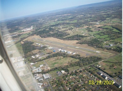
| RUSSELLVILLE RGNL RUSSELLVILLE AR |
| |
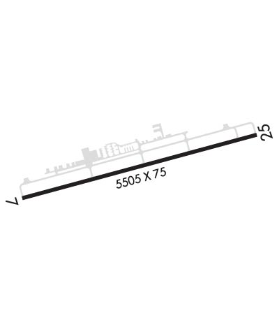
| Lat: N 3515.6 Long: W 09305.6 Elev: 409 Var: -03 Longest Runway: 5505 | ||
| AWOS: 132.47 CTAF: 122.7 | ||
| ||||||||||||||||||||||||||||||||||||||||||||
| ||||||||||||||||||||||||||||||||||||||||||||
| ||||||||||||||||||||||||||||||||||||||||||||
| Rwy | Rwy | |||||||
| 5505x75 | 5505' | 5505x75 | 4799' | |||||
| Runway ID | Single Wheel | Double Wheel | Double Tandem Wheel | Dual Double Wheel |
| 07/25 | 32,000 | 46,000 | N/A | N/A |
| These numbers are Advisory and are not limits. The Airport Manager should have more accurate Weight Limits | ||||
 Airport Diagram might not be current. | |
| Facility Name: | RUSSELLVILLE RGNL |
| City Name: | RUSSELLVILLE |
| County: | POPE |
| State abbrev: | AR |
| State Name: | ARKANSAS |
| Ownership: | PUBLICLY OWNED |
| Use: | OPEN TO THE PUBLIC |
| Owner's Name: | CITY OF RUSSELLVILLE |
| Address: | 203 S. COMMERCE STR |
| RUSSELLVILLE, AR 72801 | |
| Owner's Phone: | 479-968-2098 |
| Manager's Name: | KEITH FRAZIER |
| Address: | 1759 AIRPORT ROAD |
| RUSSELLVILLE, AR 72802 | |
| Phone: | 479-967-1227 |
| FAA Region: | SOUTHWEST |
| FAA Field Office: | AOK |
| Date | Sunrise | Sunset |
|---|---|---|
| 09/24/21 Friday | 7:02 | 19:07 |
| 09/25/21 Saturday | 7:02 | 19:05 |
| 09/26/21 Sunday | 7:03 | 19:04 |
| 09/27/21 Monday | 7:04 | 19:02 |
| 09/28/21 Tuesday | 7:05 | 19:01 |
| 09/29/21 Wednesday | 7:05 | 18:59 |
| 09/30/21 Thursday | 7:06 | 18:58 |
| 10/01/21 Friday | 7:07 | 18:57 |
| 10/02/21 Saturday | 7:08 | 18:55 |
| 10/03/21 Sunday | 7:09 | 18:54 |
| 10/04/21 Monday | 7:09 | 18:52 |
| 10/05/21 Tuesday | 7:10 | 18:51 |
| 10/06/21 Wednesday | 7:11 | 18:50 |
| 10/07/21 Thursday | 7:12 | 18:48 |
| Airport Attendance Schedule | NOV-MAR SAT-SUN 0800-1700, NOV-MAR M-F 0730-1700, MAR-NOV M-F 0730-1830, MAR-NOV SAT-SUN 0800-1800; FOR SVC AFT HRS CALL 479-857-0362 |
| Airport Status | OPERATIONAL (This Status can change at any time - please check NOTAMS) |
| Airport Lighting Schedule | DUSK-DAWN. ACTVT PAPI RWYS 07 & 25; MIRL 07/25 - CTAF. |
| Airport Storage Available | Tie Downs |
| Extra Services Available | Air Freight, Crop Dusting, Air Ambulance, Flight Instruction, Aircraft Rental |
| Wind Indicator | YES - (lighted) |
| Control Tower | NO |
| CTAF Frequency | 122.700 |
| Unicom Frequency | 122.700 |
| Rotating Beacon Color | CLEAR-GREEN (Light Land Airport) |
| Segmented Circle | Y-L |
| Landing Fee | NO |
| Airport Inspected | STATE - performed by STATE AERONAUTICAL PERSONNEL |
| Inspection Date | 04/11/2018 |
| Type of Fuel Available | Grade 100LL, JET A (freeze point -40C); -10SELF SVC FUEL AVBL 24 HRS WITH CREDIT CARD (100 LL) |
| Airframe Repair Service | MAJOR |
| Power Plant Repair Service | MAJOR |
| Latitude | N3515.6 |
| Longitude | W09305.6 (ESTIMATED) |
| Arpt Elevation | 409ft (SURVEYED) |
| Magnetic Variation | 03E |
| 2 miles SE | of RUSSELLVILLE |
| Traffic Pattern Altitude | 1005 |
| Sectional Chart | MEMPHIS |
| Operations (Reported) | Yearly | Avg. Daily |
|---|---|---|
| General Aviation Transient | 5000 | 14 |
| General Aviation Local | 5000 | 14 |
| Air Taxi | 100 | 0 |
| Commerical | 0 | 0 |
| Commuter | 0 | 0 |
| Military | 200 | 1 |
| Aircraft based on Field | |
|---|---|
| General Aviation Singles | 37 |
| General Aviation Multi | 7 |
| Jet Aircraft | 3 |
| General Aviation Helicopters | 4 |
| Military Aircraft | 0 |
| Gliders | 0 |
| Ultralights | 0 |
| FSS on field | NO |
| FSS tie-in | JONESBORO |
| FSS Phone | 1-800-WX-BRIEF |
| Who issues Notams | RUE |
| Notam D service at airport | YES |
| ARTCC Name | MEMPHIS |
| Airport Certification | |
| Aircraft Rescue & Firefighting Index | None |
| Airport of Entry | No |
| Custom Landing Rights | No |
| Joint Civil/Military | No |
| Military Landing rights | YES |
| NATIONAL PLAN OF INTEGRATED AIRPORT SYSTEMS (NPIAS) |
| GRANT AGREEMENTS UNDER FAAP/ADAP/AIP |
| ASSURANCES PURSUANT TO TITLE VI, CIVIL RIGHTS ACT OF 1964 |
| FLOCKS OF MIGRATORY BIRDS INVOF ARPT. |
| DEER ON & INVOF RY. |
| FOR CD CTC MEMPHIS ARTCC AT 901-368-8453/8449. |
| HELI SERVICE CENTER ON FLD. |
Airport Communications & Frequencies:
| |||||||||
| Runway: 07 | Runway: 25 | ||
| Mag heading: | 72° | Mag heading: | 252° |
| Rwy Slope: | .71% Up | Rwy Slope: | -.71% Down |
| Approach: | Approach: | ||
| Pattern: | Left Traffic | Pattern: | Left Traffic |
| Markings: | NONPRECISION INSTRUMENT | Markings: | NONPRECISION INSTRUMENT |
| Marking Condition: | GOOD | Marking Condition: | GOOD |
| Arresting Dev: | Arresting Dev: | ||
| Lat & Long: | N3515.4 W09306.1 | Lat. & Long.: | N3515.7 W09305.0 |
| Elev: | 370.1 ft. MSL | Elev: | 409.2 ft. MSL |
| TCH: | 60 ft. AGL | TCH: | 83 ft. AGL |
| Visual Glide Path: | 3.00 degrees | Visual Glide Path: | 4.00 degrees |
| Displaced Threshold: | No | Displaced Threshold: | 706 feet |
| Touchdown Zone: | YES | Touchdown Zone: | YES |
| Touchdown Elev.: | 389.5 feet | Touchdown Elev.: | 403.6 feet |
| Visual Glide Slope: | 4-Light PAPI on LEFT side of Runway | Visual Glide Slope: | 4-Light PAPI on LEFT side of Runway |
| RVR Equipment: | RVR Equipment: | ||
| RVV Equipment: | NO | RVV Equipment: | NO |
| Approach Lights: | Approach Lights: | ||
| REIL: | YES | REIL: | NO |
| Centerline Lights: | NO | Centerline Lights: | NO |
| Touchdown lights: | NO | Touchdown lights: | NO |
| Runway Category: | Runway with a Non-precision Approach having visibility minimums greater than 3/4 mile | Runway Category: | Runway with a Non-precision Approach having visibility minimums greater than 3/4 mile |
| Declared Distances: | Declared Distances: | ||
| Obstructions: | TREE | Obstructions: | TREE |
| Marked: | NOT Marked/Lighted | Marked: | NOT Marked/Lighted |
| Clearance slope: | 36:1 | Clearance slope: | 20:1; APCH SLOPE 29:1 TO DSPLCD THLD. |
| Obstruction height: | 35 feet AGL | Obstruction height: | 78 feet AGL |
| Dist. from runway: | 1475 feet | Dist. from runway: | 1825 feet |
| Centerline offset: | 125 right of centerline | Centerline offset: | 115 feet right of centerline |
| Comments: | Comments: |
Thanks for using FltPlan.com
all rights reserved © 1999-2021 by Flight Plan LLC