| CHICAGO/ROCKFORD INTL CHICAGO/ROCKFORD IL |
| |
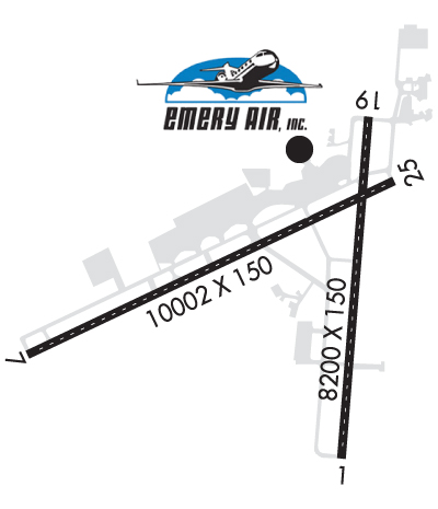
| Lat: N 4211.7 Long: W 08905.8 Elev: 742 Var: +03 Longest Runway: 10002 | ||
| Clr Del: 119.25 Dept. ATIS: 127.6 Arr. ATIS: 127.6 Ground: 121.9 Tower: 118.1 | ||
| |||||||||||||||||||||||||||||||||||||||||||||||||||||||||||||||||||||
| |||||||||||||||||||||||||||||||||||||||||||||||||||||||||||||||||||||
| |||||||||||||||||||||||||||||||||||||||||||||||||||||||||||||||||||||
| |||||||||||||||||||||||||||||||||||||||||||||||||||||||||||||||||||||
| Rwy | Rwy | |||||||
| 8200x150 | 8200' | 109.30 - 008° | 8200x150 | 8200' | ||||
| 10002x150 | 10002' | 109.55 - 068° | 10002x150 | 10002' | ||||
| Runway ID | Single Wheel | Double Wheel | Double Tandem Wheel | Dual Double Wheel |
| 01/19 | 100,000 | 210,000 | 390,000 | 850,000 |
| 07/25 | 100,000 | 190,000 | 360,000 | 850,000 |
| These numbers are Advisory and are not limits. The Airport Manager should have more accurate Weight Limits | ||||
 Airport Diagram might not be current. | |
| Facility Name: | CHICAGO/ROCKFORD INTL |
| City Name: | CHICAGO/ROCKFORD |
| County: | WINNEBAGO |
| State abbrev: | IL |
| State Name: | ILLINOIS |
| Ownership: | PUBLICLY OWNED |
| Use: | OPEN TO THE PUBLIC |
| Owner's Name: | GREATER ROCKFORD ARPT. AUTH. |
| Address: | 60 ARPT DRIVE |
| ROCKFORD, IL 61109-2902 | |
| Owner's Phone: | 815-969-4011 |
| Manager's Name: | MIKE DUNN |
| Address: | 60 AIRPORT DR |
| ROCKFORD, IL 61109-2902 | |
| Phone: | 815-965-4011 |
| FAA Region: | GREAT LAKES |
| FAA Field Office: | CHI |
| Date | Sunrise | Sunset |
|---|---|---|
| 09/24/21 Friday | 6:46 | 18:51 |
| 09/25/21 Saturday | 6:47 | 18:49 |
| 09/26/21 Sunday | 6:48 | 18:47 |
| 09/27/21 Monday | 6:49 | 18:45 |
| 09/28/21 Tuesday | 6:50 | 18:44 |
| 09/29/21 Wednesday | 6:51 | 18:42 |
| 09/30/21 Thursday | 6:52 | 18:40 |
| 10/01/21 Friday | 6:53 | 18:38 |
| 10/02/21 Saturday | 6:54 | 18:37 |
| 10/03/21 Sunday | 6:55 | 18:35 |
| 10/04/21 Monday | 6:56 | 18:33 |
| 10/05/21 Tuesday | 6:58 | 18:31 |
| 10/06/21 Wednesday | 6:59 | 18:30 |
| 10/07/21 Thursday | 7:00 | 18:28 |
| Airport Attendance Schedule | CONTINUOUS |
| Airport Status | OPERATIONAL (This Status can change at any time - please check NOTAMS) |
| Airport Lighting Schedule | |
| Airport Storage Available | Tie Downs, Hanger |
| Extra Services Available | Cargo Handling, Charter, Flight Instruction, Aircraft Rental |
| Wind Indicator | YES - (lighted) |
| Control Tower | YES |
| CTAF Frequency | |
| Unicom Frequency | 122.950 |
| Rotating Beacon Color | CLEAR-GREEN (Light Land Airport) |
| Segmented Circle | NO |
| Landing Fee | NO |
| Airport Inspected | FEDERAL - performed by FAA AIRPORTS FIELD PERSONNEL |
| Inspection Date | 02/21/2019 |
| Type of Fuel Available | Grade 100LL, JET A (freeze point -40C), JET A-1 (icing inhibitor, freeze point -50C) |
| Airframe Repair Service | MAJOR |
| Power Plant Repair Service | MAJOR |
| Latitude | N4211.7 |
| Longitude | W08905.8 (ESTIMATED) |
| Arpt Elevation | 742ft (SURVEYED) |
| Magnetic Variation | 03W |
| 68 miles NW | of CHICAGO/ROCKFORD |
| Traffic Pattern Altitude | |
| Sectional Chart | CHICAGO |
| Operations (Reported) | Yearly | Avg. Daily |
|---|---|---|
| General Aviation Transient | 14495 | 40 |
| General Aviation Local | 5403 | 15 |
| Air Taxi | 1289 | 4 |
| Commerical | 17810 | 49 |
| Commuter | 0 | 0 |
| Military | 1496 | 4 |
| Aircraft based on Field | |
|---|---|
| General Aviation Singles | 78 |
| General Aviation Multi | 18 |
| Jet Aircraft | 15 |
| General Aviation Helicopters | 3 |
| Military Aircraft | 0 |
| Gliders | 0 |
| Ultralights | 0 |
| FSS on field | NO |
| FSS tie-in | KANKAKEE |
| FSS Phone | 1-800-WX-BRIEF |
| Who issues Notams | RFD |
| Notam D service at airport | YES |
| ARTCC Name | CHICAGO |
| Airport Certification | AIRPORT RECEIVING SCHEDULED AIR CARRIER SERVICE FROM CARRIERS CERTIFICATED BY THE CIVIL AERONAUTICS BOARD |
| Aircraft Rescue & Firefighting Index | AIRPORT HAS A CERTIFICATE UNDER CFR PART 139 |
| Airport of Entry | No |
| Custom Landing Rights | YES |
| Joint Civil/Military | No |
| Military Landing rights | YES |
| NATIONAL PLAN OF INTEGRATED AIRPORT SYSTEMS (NPIAS) |
| GRANT AGREEMENTS UNDER FAAP/ADAP/AIP |
| SURPLUS PROPERTY AGREEMENT UNDER PUBLIC LAW 289 |
| CONVEYANCE UNDER SCETION 16, FEDERAL AIRPORT ACT OF 1946 OR SECTION 23, AIRPORT AND AIRWAY DEVELOPMENT ACT OF 1970 |
| ASSURANCES PURSUANT TO TITLE VI, CIVIL RIGHTS ACT OF 1964 |
| ARFF INDEX E EQUIP AVBL WITH 1 HR PPR CALL 815-969-4011 |
| BIRDS & DEER ON & INVOF ARPT. |
| TRIPLE-TANDEM TRT550 RY 07/25 & TRT590 RY 01/19. |
| US CUSTOMS OFFICE RQR 2 HR ADVANCE NOTICE DURING BUSINESS HRS MON-FRI 0830-1700. |
| RWY 07/2 5 CONC PORTION GOOD CONDITION. |
Airport Communications & Frequencies:
| ||||||||||||||||||||||||||||||||
| Runway: 01 | Runway: 19 | ||
| Mag heading: | 8° | Mag heading: | 188° |
| Rwy Slope: | .33% Up | Rwy Slope: | -.33% Down |
| Approach: | ILS/DME | Approach: | |
| Pattern: | Left Traffic | Pattern: | Left Traffic |
| Markings: | PRECISION INSTRUMENT | Markings: | PRECISION INSTRUMENT |
| Marking Condition: | GOOD | Marking Condition: | GOOD |
| Arresting Dev: | Arresting Dev: | ||
| Lat & Long: | N4211.0 W08905.5 | Lat. & Long.: | N4212.4 W08905.3 |
| Elev: | 708.8 ft. MSL | Elev: | 735.8 ft. MSL |
| TCH: | TCH: | 75 ft. AGL | |
| Visual Glide Path: | Visual Glide Path: | 3.00 degrees | |
| Displaced Threshold: | No | Displaced Threshold: | No |
| Touchdown Zone: | YES | Touchdown Zone: | YES |
| Touchdown Elev.: | 729.2 feet | Touchdown Elev.: | 735.9 feet |
| Visual Glide Slope: | Visual Glide Slope: | 4-Light PAPI on LEFT side of Runway | |
| RVR Equipment: | TOUCHDOWN | RVR Equipment: | ROLLOUT |
| RVV Equipment: | NO | RVV Equipment: | NO |
| Approach Lights: | MALSR - 1,400 foot medium intensity approach lighting system with runway alignment indicator lights | Approach Lights: | |
| REIL: | NO | REIL: | YES |
| Centerline Lights: | YES | Centerline Lights: | YES |
| Touchdown lights: | YES | Touchdown lights: | NO |
| Runway Category: | Precision Instrument Runway | Runway Category: | D |
| Declared Distances: | TORA:8199' TODA:8199' ASDA:8199' LDA:8199' | Declared Distances: | TORA:8199' TODA:8199' ASDA:8099' LDA:8099' |
| Obstructions: | ROAD | Obstructions: | TREE |
| Marked: | NOT Marked/Lighted | Marked: | NOT Marked/Lighted |
| Clearance slope: | 48:1 | Clearance slope: | 37:1 |
| Obstruction height: | 7 feet AGL | Obstruction height: | 65 feet AGL |
| Dist. from runway: | 541 feet | Dist. from runway: | 2613 feet |
| Centerline offset: | 542 right of centerline | Centerline offset: | 561 feet right of centerline |
| Comments: | Comments: |
| Runway: 07 | Runway: 25 | ||
| Mag heading: | 68° | Mag heading: | 248° |
| Rwy Slope: | -.06% Down | Rwy Slope: | .06% Up |
| Approach: | ILS | Approach: | |
| Pattern: | Left Traffic | Pattern: | Left Traffic |
| Markings: | PRECISION INSTRUMENT | Markings: | PRECISION INSTRUMENT |
| Marking Condition: | GOOD | Marking Condition: | GOOD |
| Arresting Dev: | Arresting Dev: | ||
| Lat & Long: | N4211.4 W08907.2 | Lat. & Long.: | N4212.1 W08905.2 |
| Elev: | 742.0 ft. MSL | Elev: | 735.9 ft. MSL |
| TCH: | 69 ft. AGL | TCH: | 75 ft. AGL |
| Visual Glide Path: | 3.00 degrees | Visual Glide Path: | 3.00 degrees |
| Displaced Threshold: | No | Displaced Threshold: | No |
| Touchdown Zone: | YES | Touchdown Zone: | YES |
| Touchdown Elev.: | 742.0 feet | Touchdown Elev.: | 736.1 feet |
| Visual Glide Slope: | 4-Light PAPI on RIGHT side of Runway | Visual Glide Slope: | 4-Light PAPI on LEFT side of Runway |
| RVR Equipment: | TOUCHDOWN-MIDFIELD-ROLLOUT | RVR Equipment: | TOUCHDOWN-MIDFIELD-ROLLOUT |
| RVV Equipment: | NO | RVV Equipment: | NO |
| Approach Lights: | ALSF2 - standard 2,400 foot high intensity approach lighting system with sequenced flashers, Category II or III | Approach Lights: | |
| REIL: | NO | REIL: | YES |
| Centerline Lights: | YES | Centerline Lights: | YES |
| Touchdown lights: | YES | Touchdown lights: | NO |
| Runway Category: | Precision Instrument Runway | Runway Category: | Runway with a Non-precision Approach having visibility minimums greater than 3/4 mile |
| Declared Distances: | TORA:10002' TODA:10002' ASDA:10002' LDA:10002' | Declared Distances: | TORA:10002' TODA:10002' ASDA:10002' LDA:10002' |
| Obstructions: | TREES | Obstructions: | TREE |
| Marked: | NOT Marked/Lighted | Marked: | NOT Marked/Lighted |
| Clearance slope: | 34:1 | Clearance slope: | 20:1 |
| Obstruction height: | 128 feet AGL | Obstruction height: | 51 feet AGL |
| Dist. from runway: | 4660 feet | Dist. from runway: | 1222 feet |
| Centerline offset: | 1236 right of centerline | Centerline offset: | 420 feet left of centerline |
| Comments: | Comments: |
Thanks for using FltPlan.com
all rights reserved © 1999-2021 by Flight Plan LLC