
| HUDSON VALLEY REGIONAL AIRPORT POUGHKEEPSIE NY |
| |
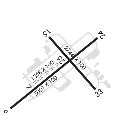
| Lat: N 4137.6 Long: W 07353.1 Elev: 164 Var: +12 Longest Runway: 5001 | ||
| Clr Del: 121.8 Dept. ATIS: 126.75 Arr. ATIS: 126.75 AWOS: 126.75 Ground: 121.8 Tower: 124.0 | ||
| ||||||||||||||||||||||||||||||||||||||||||||
| ||||||||||||||||||||||||||||||||||||||||||||
| ||||||||||||||||||||||||||||||||||||||||||||
| Rwy | Rwy | |||||||
| 5001x100 | 5001' | 111.30 - 063° | 5001x100 | 4886' | ||||
| 1358x100 | 1358' | 1358x100 | 1358' | |||||
| 2744x100 | 2744' | 2744x100 | 2744' | |||||
| Runway ID | Single Wheel | Double Wheel | Double Tandem Wheel | Dual Double Wheel |
| 06/24 | 50,000 | 60,000 | 110,000 | N/A |
| 07/25 | N/A | N/A | N/A | N/A |
| 15/33 | 35,000 | 45,000 | 80,000 | N/A |
| These numbers are Advisory and are not limits. The Airport Manager should have more accurate Weight Limits | ||||
 Airport Diagram might not be current. | |
| Facility Name: | HUDSON VALLEY RGNL |
| City Name: | POUGHKEEPSIE |
| County: | DUTCHESS |
| State abbrev: | NY |
| State Name: | NEW YORK |
| Ownership: | PUBLICLY OWNED |
| Use: | OPEN TO THE PUBLIC |
| Owner's Name: | DUTCHESS COUNTY |
| Address: | 22 MARKET ST |
| POUGHKEEPSIE, NY 12601 | |
| Owner's Phone: | 845-486-2000 |
| Manager's Name: | JEFF DURAND |
| Address: | 263 NEW HACKENSACK RD |
| WAPPINGERS FALLS, NY 12590 | |
| Phone: | 845-463-6000 |
| FAA Region: | EASTERN |
| FAA Field Office: | NYC |
| Date | Sunrise | Sunset |
|---|---|---|
| 09/24/21 Friday | 6:45 | 18:50 |
| 09/25/21 Saturday | 6:46 | 18:48 |
| 09/26/21 Sunday | 6:47 | 18:46 |
| 09/27/21 Monday | 6:48 | 18:45 |
| 09/28/21 Tuesday | 6:49 | 18:43 |
| 09/29/21 Wednesday | 6:50 | 18:41 |
| 09/30/21 Thursday | 6:51 | 18:39 |
| 10/01/21 Friday | 6:52 | 18:38 |
| 10/02/21 Saturday | 6:53 | 18:36 |
| 10/03/21 Sunday | 6:54 | 18:34 |
| 10/04/21 Monday | 6:55 | 18:33 |
| 10/05/21 Tuesday | 6:56 | 18:31 |
| 10/06/21 Wednesday | 6:57 | 18:29 |
| 10/07/21 Thursday | 6:58 | 18:28 |
| Airport Attendance Schedule | 7 Days A Week 0700-2130 |
| Airport Status | OPERATIONAL (This Status can change at any time - please check NOTAMS) |
| Airport Lighting Schedule | WHEN ATCT CLSD ACTIVATE HIRL RY 06/24; REILS RY 24; MALSR RY 06 - CTAF. |
| Airport Storage Available | Tie Downs, Hanger |
| Extra Services Available | Cargo Handling, Charter, Flight Instruction, Aircraft Rental, Aircraft Sales |
| Wind Indicator | YES - (lighted) |
| Control Tower | YES |
| CTAF Frequency | 124.000 |
| Unicom Frequency | 122.950 |
| Rotating Beacon Color | CLEAR-GREEN (Light Land Airport) |
| Segmented Circle | NO |
| Landing Fee | YES; LANDING FEE FOR MULTI-ENGINE AIRCRAFT. |
| Airport Inspected | FEDERAL - performed by STATE AERONAUTICAL PERSONNEL |
| Inspection Date | 06/04/2021 |
| Type of Fuel Available | Grade 100LL, JET A (freeze point -40C) |
| Airframe Repair Service | MAJOR |
| Power Plant Repair Service | MAJOR |
| Latitude | N4137.6 |
| Longitude | W07353.1 (ESTIMATED) |
| Arpt Elevation | 163ft (SURVEYED) |
| Magnetic Variation | 12W |
| 4 miles S | of POUGHKEEPSIE |
| Traffic Pattern Altitude | TPA SMALL ACFT 1034 FT, LARGE ACFT 1834 FT. |
| Sectional Chart | NEW YORK |
| Operations (Reported) | Yearly | Avg. Daily |
|---|---|---|
| General Aviation Transient | 21041 | 58 |
| General Aviation Local | 27093 | 74 |
| Air Taxi | 2382 | 7 |
| Commerical | 16 | 0 |
| Commuter | 0 | 0 |
| Military | 204 | 1 |
| Aircraft based on Field | |
|---|---|
| General Aviation Singles | 73 |
| General Aviation Multi | 5 |
| Jet Aircraft | 0 |
| General Aviation Helicopters | 4 |
| Military Aircraft | 2 |
| Gliders | 0 |
| Ultralights | 0 |
| FSS on field | NO |
| FSS tie-in | NEW YORK |
| FSS Phone | 1-800-WX-BRIEF |
| Who issues Notams | POU |
| Notam D service at airport | YES |
| ARTCC Name | NEW YORK |
| Airport Certification | PPR 24 HRS FOR ACR OPNS WITH MORE THAN 30 PSGR SEATS; CALL AMGR 845-463-6000. INDEX "B" COVERAGE IS PRVDD. |
| Aircraft Rescue & Firefighting Index | AIRPORT HAS A CERTIFICATE UNDER CFR PART 139 |
| Airport of Entry | No |
| Custom Landing Rights | No |
| Joint Civil/Military | No |
| Military Landing rights | YES |
| NATIONAL PLAN OF INTEGRATED AIRPORT SYSTEMS (NPIAS) |
| GRANT AGREEMENTS UNDER FAAP/ADAP/AIP |
| SURPLUS PROPERTY AGREEMENT UNDER REGULATION 16-WAA |
| ASSURANCES PURSUANT TO TITLE VI, CIVIL RIGHTS ACT OF 1964 |
| CTC FBO DURING BUSINESS HRS AT (845) 849-3770 FOR AFTER HRS FUEL SERVICE. |
| TWY B-1; 'G' T-HGR TAXILANE; & 'J' T-HGR TAXILANE CLSD TO AIR CARRIER ACFT. |
| FOR CD WHEN ATCT CLSD CTC NEW YORK APCH AT 516-683-2448 OR 121.8. |
| RWY 15/33 CLSD TO ACR ACFT. |
| NOISE ABATEMENT PROCEDURES IN EFFECT CTC ARPT MGR FOR DETAILS. |
| BIRDS & DEER ON & INVOF ARPT. |
| RWY 07/25 RESTRICTED TO ACFT LESS THAN 12,500 LBS. |
| RWY 07/2 5 CLSD NGTS; DURING IMC & FROM NOV 1 - APR 15. |
Airport Communications & Frequencies:
| ||||||||||||||||||||||||
| Runway: 06 | Runway: 24 | ||
| Mag heading: | 63° | Mag heading: | 243° |
| Rwy Slope: | .16% Up | Rwy Slope: | -.16% Down |
| Approach: | ILS | Approach: | |
| Pattern: | Left Traffic | Pattern: | Left Traffic |
| Markings: | PRECISION INSTRUMENT | Markings: | NONPRECISION INSTRUMENT |
| Marking Condition: | GOOD | Marking Condition: | GOOD |
| Arresting Dev: | Arresting Dev: | ||
| Lat & Long: | N4137.3 W07353.5 | Lat. & Long.: | N4137.8 W07352.7 |
| Elev: | 146.7 ft. MSL | Elev: | 154.8 ft. MSL |
| TCH: | 57 ft. AGL | TCH: | 57 ft. AGL |
| Visual Glide Path: | 3.00 degrees | Visual Glide Path: | 3.42 degrees |
| Displaced Threshold: | No | Displaced Threshold: | 115 feet |
| Touchdown Zone: | YES | Touchdown Zone: | YES |
| Touchdown Elev.: | 156.0 feet | Touchdown Elev.: | 156.9 feet |
| Visual Glide Slope: | 4-Light PAPI on LEFT side of Runway | Visual Glide Slope: | 4-Light PAPI on LEFT side of Runway |
| RVR Equipment: | RVR Equipment: | ||
| RVV Equipment: | NO | RVV Equipment: | NO |
| Approach Lights: | MALSR - 1,400 foot medium intensity approach lighting system with runway alignment indicator lights | Approach Lights: | |
| REIL: | NO | REIL: | YES |
| Centerline Lights: | NO | Centerline Lights: | NO |
| Touchdown lights: | NO | Touchdown lights: | NO |
| Runway Category: | Precision Instrument Runway | Runway Category: | Runway with a Non-precision Approach having visibility minimums greater than 3/4 mile |
| Declared Distances: | TORA:5001' TODA:5001' ASDA:5001' LDA:5001' | Declared Distances: | TORA:5001' TODA:5001' ASDA:5001' LDA:4888' |
| Obstructions: | TREE | Obstructions: | TREE |
| Marked: | NOT Marked/Lighted | Marked: | LIGHTED |
| Clearance slope: | 10:1 | Clearance slope: | RY 24 APCH SLOPE 4:1 TO DSPLCD THR. |
| Obstruction height: | 18 feet AGL | Obstruction height: | 71 feet AGL |
| Dist. from runway: | 380 feet | Dist. from runway: | 210 feet |
| Centerline offset: | 300 left of centerline | Centerline offset: | 400 feet left of centerline |
| Comments: | Comments: |
| Runway: 07 | Runway: 25 | ||
| Mag heading: | 63° | Mag heading: | 243° |
| Rwy Slope: | .13% Up | Rwy Slope: | -.13% Down |
| Approach: | Approach: | ||
| Pattern: | Left Traffic | Pattern: | Left Traffic |
| Markings: | Markings: | ||
| Marking Condition: | Marking Condition: | ||
| Arresting Dev: | Arresting Dev: | ||
| Lat & Long: | N4137.5 W07353.3 | Lat. & Long.: | N4137.6 W07353.1 |
| Elev: | 151.6 ft. MSL | Elev: | 153.4 ft. MSL |
| TCH: | TCH: | ||
| Visual Glide Path: | Visual Glide Path: | ||
| Displaced Threshold: | No | Displaced Threshold: | No |
| Touchdown Zone: | YES | Touchdown Zone: | YES |
| Touchdown Elev.: | 153.4 feet | Touchdown Elev.: | 153.4 feet |
| Visual Glide Slope: | Visual Glide Slope: | ||
| RVR Equipment: | RVR Equipment: | ||
| RVV Equipment: | NO | RVV Equipment: | NO |
| Approach Lights: | Approach Lights: | ||
| REIL: | NO | REIL: | NO |
| Centerline Lights: | NO | Centerline Lights: | NO |
| Touchdown lights: | NO | Touchdown lights: | NO |
| Runway Category: | Runway with a Visual Approach | Runway Category: | Runway with a Visual Approach |
| Declared Distances: | TORA:1358' TODA:1358' ASDA:1358' LDA:1358' | Declared Distances: | TORA:1358' TODA:1358' ASDA:1358' LDA:1358' |
| Obstructions: | Obstructions: | ANT | |
| Marked: | Marked: | MARKED and LIGHTED | |
| Clearance slope: | 20:1 | Clearance slope: | 8:1 |
| Obstruction height: | Obstruction height: | 24 feet AGL | |
| Dist. from runway: | Dist. from runway: | 215 feet | |
| Centerline offset: | Centerline offset: | 90 feet right of centerline | |
| Comments: | Comments: |
| Runway: 15 | Runway: 33 | ||
| Mag heading: | 151° | Mag heading: | 331° |
| Rwy Slope: | .29% Up | Rwy Slope: | -.29% Down |
| Approach: | Approach: | ||
| Pattern: | Left Traffic | Pattern: | Left Traffic |
| Markings: | BASIC | Markings: | BASIC |
| Marking Condition: | GOOD | Marking Condition: | GOOD |
| Arresting Dev: | Arresting Dev: | ||
| Lat & Long: | N4137.8 W07353.1 | Lat. & Long.: | N4137.5 W07352.7 |
| Elev: | 155.6 ft. MSL | Elev: | 163.5 ft. MSL |
| TCH: | TCH: | 64 ft. AGL | |
| Visual Glide Path: | Visual Glide Path: | 3.75 degrees | |
| Displaced Threshold: | No | Displaced Threshold: | No |
| Touchdown Zone: | YES | Touchdown Zone: | YES |
| Touchdown Elev.: | 163.5 feet | Touchdown Elev.: | 163.5 feet |
| Visual Glide Slope: | Visual Glide Slope: | 4-BOX VASI ON LEFT SIDE OF RUNWAY; USE OF VASI RSTD TO CATEGORY A ACFT ONLY. | |
| RVR Equipment: | RVR Equipment: | ||
| RVV Equipment: | NO | RVV Equipment: | NO |
| Approach Lights: | Approach Lights: | ||
| REIL: | NO | REIL: | YES |
| Centerline Lights: | NO | Centerline Lights: | NO |
| Touchdown lights: | NO | Touchdown lights: | NO |
| Runway Category: | Runway with a Visual Approach | Runway Category: | Runway with a Visual Approach |
| Declared Distances: | TORA:2743' TODA:2743' ASDA:2743' LDA:2743' | Declared Distances: | TORA:2743' TODA:2743' ASDA:2743' LDA:2743' |
| Obstructions: | TREES | Obstructions: | TREES |
| Marked: | NOT Marked/Lighted | Marked: | NOT Marked/Lighted |
| Clearance slope: | 13:1 | Clearance slope: | 1:1 |
| Obstruction height: | 51 feet AGL | Obstruction height: | 37 feet AGL |
| Dist. from runway: | 900 feet | Dist. from runway: | 240 feet |
| Centerline offset: | 100 right of centerline | Centerline offset: | 200 feet left of centerline |
| Comments: | Comments: | RY 33 +13 FT OBSTRUCTION LGTD POLE 160 FT FM THLD 150 FT LEFT. |
Thanks for using FltPlan.com
all rights reserved © 1999-2021 by Flight Plan LLC