
| PALM BEACH CO GLADES PAHOKEE FL |
| |
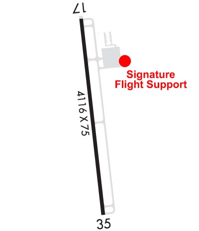
| Lat: N 2647.1 Long: W 08041.6 Elev: 16 Var: +07 Longest Runway: 4116 | ||
| AWOS: 124.17 CTAF: 122.8 | ||
| ||||||||||||||||||||||||||||||||||||||||||||
| ||||||||||||||||||||||||||||||||||||||||||||
| Rwy | Rwy | |||||||
| 4116x75 | 4016' | 4116x75 | 4064' | |||||
| Runway ID | Single Wheel | Double Wheel | Double Tandem Wheel | Dual Double Wheel |
| 18/36 | 20,000 | N/A | N/A | N/A |
| These numbers are Advisory and are not limits. The Airport Manager should have more accurate Weight Limits | ||||
 Airport Diagram might not be current. | |
| Facility Name: | PALM BEACH COUNTY GLADES |
| City Name: | PAHOKEE |
| County: | PALM BEACH |
| State abbrev: | FL |
| State Name: | FLORIDA |
| Ownership: | PUBLICLY OWNED |
| Use: | OPEN TO THE PUBLIC |
| Owner's Name: | PALM BEACH COUNTY |
| Address: | DEPARTMENT OF AIRPORTS, 846 PBIA |
| WEST PALM BEACH, FL 33406-1491 | |
| Owner's Phone: | 561-471-7420 |
| Manager's Name: | LAURA BEEBE |
| Address: | 846 PALM BEACH INTL AIRPORT |
| WEST PALM BEACH, FL 33406-1470 | |
| Phone: | 561-471-7420 |
| FAA Region: | SOUTHERN |
| FAA Field Office: | ORL |
| Date | Sunrise | Sunset |
|---|---|---|
| 09/24/21 Friday | 7:12 | 19:17 |
| 09/25/21 Saturday | 7:12 | 19:16 |
| 09/26/21 Sunday | 7:13 | 19:15 |
| 09/27/21 Monday | 7:13 | 19:14 |
| 09/28/21 Tuesday | 7:14 | 19:13 |
| 09/29/21 Wednesday | 7:14 | 19:12 |
| 09/30/21 Thursday | 7:15 | 19:10 |
| 10/01/21 Friday | 7:15 | 19:09 |
| 10/02/21 Saturday | 7:16 | 19:08 |
| 10/03/21 Sunday | 7:16 | 19:07 |
| 10/04/21 Monday | 7:17 | 19:06 |
| 10/05/21 Tuesday | 7:17 | 19:05 |
| 10/06/21 Wednesday | 7:18 | 19:04 |
| 10/07/21 Thursday | 7:18 | 19:03 |
| Airport Attendance Schedule | 7 Days A Week 0800-1800; SVC AFT HR - 561-626-9799. |
| Airport Status | OPERATIONAL (This Status can change at any time - please check NOTAMS) |
| Airport Lighting Schedule | ACTVT MIRL RWY 18/36 - CTAF. |
| Airport Storage Available | Tie Downs, Hanger |
| Extra Services Available | Parachute Jumping |
| Wind Indicator | YES - (lighted) |
| Control Tower | NO |
| CTAF Frequency | 122.800 |
| Unicom Frequency | 122.800 |
| Rotating Beacon Color | CLEAR-GREEN (Light Land Airport) |
| Segmented Circle | Y-L |
| Landing Fee | NO |
| Airport Inspected | STATE - performed by STATE AERONAUTICAL PERSONNEL |
| Inspection Date | 01/12/2018 |
| Type of Fuel Available | Grade 100LL, JET A (freeze point -40C) |
| Airframe Repair Service | NONE |
| Power Plant Repair Service | NONE |
| Latitude | N2647.1 |
| Longitude | W08041.6 (ESTIMATED) |
| Arpt Elevation | 15ft (SURVEYED) |
| Magnetic Variation | 07W |
| 3 miles SW | of PAHOKEE |
| Traffic Pattern Altitude | |
| Sectional Chart | MIAMI |
| Operations (Reported) | Yearly | Avg. Daily |
|---|---|---|
| General Aviation Transient | 29200 | 80 |
| General Aviation Local | 7300 | 20 |
| Air Taxi | 250 | 1 |
| Commerical | 0 | 0 |
| Commuter | 0 | 0 |
| Military | 0 | 0 |
| Aircraft based on Field | |
|---|---|
| General Aviation Singles | 10 |
| General Aviation Multi | 1 |
| Jet Aircraft | 0 |
| General Aviation Helicopters | 1 |
| Military Aircraft | 0 |
| Gliders | 0 |
| Ultralights | 0 |
| FSS on field | NO |
| FSS tie-in | MIAMI |
| FSS Phone | 1-800-WX-BRIEF |
| Who issues Notams | MIA |
| Notam D service at airport | YES |
| ARTCC Name | MIAMI |
| Airport Certification | |
| Aircraft Rescue & Firefighting Index | None |
| Airport of Entry | No |
| Custom Landing Rights | No |
| Joint Civil/Military | No |
| Military Landing rights | YES |
| NATIONAL PLAN OF INTEGRATED AIRPORT SYSTEMS (NPIAS) |
| GRANT AGREEMENTS UNDER FAAP/ADAP/AIP |
| ASSURANCES PURSUANT TO TITLE VI, CIVIL RIGHTS ACT OF 1964 |
| THIS AIRPORT HAS BEEN SURVEYED BY THE NATIONAL GEODETIC SURVEY. |
| BIRDS ON AND INVOF ARPT. |
| ARPT SFC COND NOT RPRTD FOR ALL RWYS. |
| FOR CD IF UNA TO CTC ON FSS FREQ, CTC PALM BEACH APCH AT 561-275-1430 OR 561-684-9047. |
| FBO SVC FEE MAY APPLY. |
Airport Communications & Frequencies:
| ||||||||||||||
| Runway: 18 | Runway: 36 | ||
| Mag heading: | 181° | Mag heading: | 1° |
| Rwy Slope: | .01% Up | Rwy Slope: | -.01% Down |
| Approach: | Approach: | ||
| Pattern: | Left Traffic | Pattern: | Left Traffic |
| Markings: | NONPRECISION INSTRUMENT | Markings: | NONPRECISION INSTRUMENT |
| Marking Condition: | GOOD | Marking Condition: | GOOD |
| Arresting Dev: | Arresting Dev: | ||
| Lat & Long: | N2647.4 W08041.6 | Lat. & Long.: | N2646.8 W08041.6 |
| Elev: | 15.3 ft. MSL | Elev: | 15.6 ft. MSL |
| TCH: | 44 ft. AGL | TCH: | 44 ft. AGL |
| Visual Glide Path: | 3.00 degrees | Visual Glide Path: | 3.00 degrees |
| Displaced Threshold: | 100 feet | Displaced Threshold: | 52 feet |
| Touchdown Zone: | YES | Touchdown Zone: | YES |
| Touchdown Elev.: | 15.9 feet | Touchdown Elev.: | 15.8 feet |
| Visual Glide Slope: | 2-Light PAPI on LEFT side of Runway | Visual Glide Slope: | 2-Light PAPI on LEFT side of Runway |
| RVR Equipment: | RVR Equipment: | ||
| RVV Equipment: | NO | RVV Equipment: | NO |
| Approach Lights: | Approach Lights: | ||
| REIL: | YES | REIL: | YES |
| Centerline Lights: | NO | Centerline Lights: | NO |
| Touchdown lights: | NO | Touchdown lights: | NO |
| Runway Category: | Runway with a Non-precision Approach | Runway Category: | Runway with a Non-precision Approach |
| Declared Distances: | TORA:4069' TODA:4069' ASDA:4119' LDA:4016' | Declared Distances: | TORA:4016' TODA:4016' ASDA:4170' LDA:4069' |
| Obstructions: | TREE | Obstructions: | FENCE |
| Marked: | NOT Marked/Lighted | Marked: | NOT Marked/Lighted |
| Clearance slope: | 23:1; APCH RATIO 34:1 AT DSPLCD THR. | Clearance slope: | 6:1; APCH RATIO 34:1 AT DSPLCD THR DUE TO 25 FT PLINE 820 FT FM RWY END 250 FT R OF CNTRLN. |
| Obstruction height: | 36 feet AGL | Obstruction height: | 3 feet AGL |
| Dist. from runway: | 1050 feet | Dist. from runway: | 213 feet |
| Centerline offset: | 155 right of centerline | Centerline offset: | 250 feet left of centerline |
| Comments: | Comments: |
Thanks for using FltPlan.com
all rights reserved © 1999-2021 by Flight Plan LLC
