
| MIAMI-OPA LOCKA EXECUTIVE MIAMI FL |
| |
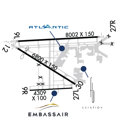
| Lat: N 2554.4 Long: W 08016.7 Elev: 8 Var: +06 Longest Runway: 8002 | ||
| Clr Del: 119.2 Dept. ATIS: 125.9 Arr. ATIS: 125.9 Ground: 120.02 Tower: 134.67 | ||
| |||||||||||||||||||||||||||||||||||||||||||||||||||||||||||||||||||||
| |||||||||||||||||||||||||||||||||||||||||||||||||||||||||||||||||||||
| |||||||||||||||||||||||||||||||||||||||||||||||||||||||||||||||||||||
| |||||||||||||||||||||||||||||||||||||||||||||||||||||||||||||||||||||
| |||||||||||||||||||||||||||||||||||||||||||||||||||||||||||||||||||||
| |||||||||||||||||||||||||||||||||||||||||||||||||||||||||||||||||||||
| FBOs at nearby airports who want your business: | |||||||||||
| |||||||||||
| Rwy | Rwy | |||||||
| 8002x150 | 8002' | 110.50 - 092° | 8002x150 | 8002' | 111.35 - 272° | |||
| 4309x100 | 4309' | 4309x100 | 4309' | |||||
| 6800x150 | 6000' | 111.55 - 127° | 6800x150 | 6800' | ||||
| Runway ID | Single Wheel | Double Wheel | Double Tandem Wheel | Dual Double Wheel |
| 09L/27R | 120,000 | 249,000 | 484,000 | 1,000,000 |
| 09R/27L | 96,000 | 154,000 | N/A | N/A |
| 12/30 | 120,000 | 249,000 | 484,000 | 1,000,000 |
| These numbers are Advisory and are not limits. The Airport Manager should have more accurate Weight Limits | ||||
 Airport Diagram might not be current. | |
| Facility Name: | MIAMI-OPA LOCKA EXEC |
| City Name: | MIAMI |
| County: | DADE |
| State abbrev: | FL |
| State Name: | FLORIDA |
| Ownership: | PUBLICLY OWNED |
| Use: | OPEN TO THE PUBLIC |
| Owner's Name: | MIAMI-DADE COUNTY; CONTACT PERSON: LIONEL BECKLES |
| Address: | MIAMI-DADE AVIATION DEPARTMENT, P.O. BOX 025504 |
| MIAMI, FL 33102-5504 | |
| Owner's Phone: | 305-876-0464 |
| Manager's Name: | JERSLEY MCFARLANE |
| Address: | 14201 NW LEJEUNE RD |
| OPA-LOCKA, FL 33054 | |
| Phone: | 305-869-1662 |
| FAA Region: | SOUTHERN |
| FAA Field Office: | ORL |
| Date | Sunrise | Sunset |
|---|---|---|
| 06/07/26 Sunday | 6:29 | 20:11 |
| 06/08/26 Monday | 6:29 | 20:12 |
| 06/09/26 Tuesday | 6:29 | 20:12 |
| 06/10/26 Wednesday | 6:29 | 20:12 |
| 06/11/26 Thursday | 6:29 | 20:13 |
| 06/12/26 Friday | 6:29 | 20:13 |
| 06/13/26 Saturday | 6:29 | 20:13 |
| 06/14/26 Sunday | 6:29 | 20:14 |
| 06/15/26 Monday | 6:29 | 20:14 |
| 06/16/26 Tuesday | 6:29 | 20:14 |
| 06/17/26 Wednesday | 6:29 | 20:15 |
| 06/18/26 Thursday | 6:29 | 20:15 |
| 06/19/26 Friday | 6:30 | 20:15 |
| 06/20/26 Saturday | 6:30 | 20:15 |
| Airport Attendance Schedule | CONTINUOUS |
| Airport Status | OPERATIONAL (This Status can change at any time - please check NOTAMS) |
| Airport Lighting Schedule | WHEN ATCT CLSD ACTVT MALSR RWY 12; PAPI RWY 12 & 30; HIRL RWY 12/30 - CTAF. 30 MIN PPR TO REQ ACTVN OF MALSR RWY 09L; MALS RWY 27R; PAPI RWY 09L & 27R; HIRL RWY 09L/27R - 305-869-1660 AND CTAF. |
| Airport Storage Available | Tie Downs, Hanger |
| Extra Services Available | Air Ambulance, Avionics, Cargo Handling, Charter, Flight Instruction, Aircraft Rental, Aircraft Sales |
| Wind Indicator | YES - (lighted) |
| Control Tower | YES |
| CTAF Frequency | 134.675 |
| Unicom Frequency | |
| Rotating Beacon Color | WG |
| Segmented Circle | Y-L |
| Landing Fee | NO |
| Airport Inspected | STATE - performed by STATE AERONAUTICAL PERSONNEL |
| Inspection Date | 05/14/2025 |
| Type of Fuel Available | Grade 100LL, JET A (freeze point -40C) |
| Airframe Repair Service | MAJOR |
| Power Plant Repair Service | MAJOR |
| Latitude | N2554.4 |
| Longitude | W08016.7 (ESTIMATED) |
| Arpt Elevation | 8ft (SURVEYED) |
| Magnetic Variation | 06W |
| 10 miles N | of MIAMI |
| Traffic Pattern Altitude | |
| Sectional Chart | MIAMI |
| Operations (Reported) | Yearly | Avg. Daily |
|---|---|---|
| General Aviation Transient | 0 | 0 |
| General Aviation Local | 0 | 0 |
| Air Taxi | 0 | 0 |
| Commerical | 0 | 0 |
| Commuter | 0 | 0 |
| Military | 0 | 0 |
| Aircraft based on Field | |
|---|---|
| General Aviation Singles | 0 |
| General Aviation Multi | 0 |
| Jet Aircraft | 0 |
| General Aviation Helicopters | 0 |
| Military Aircraft | 0 |
| Gliders | 0 |
| Ultralights | 0 |
| FSS on field | NO |
| FSS tie-in | MIAMI |
| FSS Phone | 1-800-WX-BRIEF |
| Who issues Notams | OPF |
| Notam D service at airport | YES |
| ARTCC Name | MIAMI |
| Airport Certification | |
| Aircraft Rescue & Firefighting Index | None |
| Airport of Entry | No |
| Custom Landing Rights | YES |
| Joint Civil/Military | No |
| Military Landing rights | YES |
| NATIONAL PLAN OF INTEGRATED AIRPORT SYSTEMS (NPIAS) |
| GRANT AGREEMENTS UNDER FAAP/ADAP/AIP |
| SURPLUS PROPERTY AGREEMENT UNDER PUBLIC LAW 289 |
| ASSURANCES PURSUANT TO TITLE VI, CIVIL RIGHTS ACT OF 1964 |
| THIS AIRPORT HAS BEEN SURVEYED BY THE NATIONAL GEODETIC SURVEY. |
| TWY C & B SOUTH OF P ARE NON MOVEMENT AREAS. |
| ACFT WITH WINGSPANS GTR THAN 117 FT ARE PROHIBITED FM TXIG ON TWY P BTN TWY H AND TWY N8. |
| VEHICLE LANE XNG TWY E TO THE FIRE STN IS NON-MOVEMENT. |
| ALL ACFT AND VEHICLES SHUD RPRT PSNS TO ATC BY USING THE SFC PAINTED SPOT NRS ON ALL EXITS TO THE RAMP AND NON-MOVEMENT AREAS. |
| MILITARY FUEL: CONTRACT FUEL - 305-685-4646. |
| TWY T BTN TWY E AND TWY T8 RDCD SPD RQRD FOR ACFT WINGSPAN MORE THAN 117 FT. |
| TWY R BTN TWY F & G RSTRD TO ACFT WITH WINGSPAN LESS THAN 94 FT. |
| FOR CD, IF UNA VIA GCO, CTC MIAMI APCH AT 305-869-5432. |
| GCO AVBL ON FREQ 119.45. |
| RWY 09L-27R CLSD DLY 0400-1200Z++ EXC PPR 60 MINS-305-869-1660. RWY 09R-27L CLSD DLY 0400-1200Z++. |
| MILITARY REMARKS: CG OFFL BUS, MIN 24 HR PPR (AIR STN MIAMI OPS CNTR: D07-SMB-ODOAIRSTAMIA@USCG.MIL OR 305-953-2130). CTC MIAMI AIR 345.0 15 MIN PRIOR TO ENTERING CG RAMP. NO TRAN FAC. IF DESTN CG, INCL CGAS MIAMI IN |
| 24 HR PPR FOR ACFT EQUIPPED WITH WEATHER MODIFICATION OR GEOENGINEERING EQPT 305-869-1660. |
| HEL ARR & DEP AVOID FLYING OVER PARKED OR TWY ACFT. |
| SPECIFIC TFC PATS ARE PUBLISHED FOR HEL AND FIXED WING TFC; COMPLIANCE IS MANDATORY. OBTAIN INFO FM ATCT OR FBO OR AMGR; OR REQ SPECIFIC TFC PAT INSTRUCTIONS ON INITIAL CTC. |
| DUAL TFC PATS FOR HELS & FIXED WING ACFT IN USE RWY 09R/27L. |
| BIRDS INVOF ARPT. |
| FLT NOTIFICATION SVC (ADCUS) AVBL 0800-2300. |
| NOISE SENSITIVE ARPT. FLT T IS LTD TO ACFT 40000 LBS MAX GROSS TKOF WT & BLW & ONLY BTN 0700-2300. |
| RWY 09R/ 27LCLSD DLY 0400-1200++ FOR ACFT NOISE ABATEMENT TO SRNDG ARPT COMMUNITY. |
Airport Communications & Frequencies:
| ||||||||||||||||||||
| Runway: 09L | Runway: 27R | ||
| Mag heading: | 93° | Mag heading: | 273° |
| Rwy Slope: | .01% Up | Rwy Slope: | -.01% Down |
| Approach: | ILS | Approach: | ILS/DME |
| Pattern: | Left Traffic | Pattern: | Right Traffic |
| Markings: | PRECISION INSTRUMENT | Markings: | PRECISION INSTRUMENT |
| Marking Condition: | GOOD | Marking Condition: | GOOD |
| Arresting Dev: | Arresting Dev: | ||
| Lat & Long: | N2554.8 W08017.3 | Lat. & Long.: | N2554.8 W08015.9 |
| Elev: | 6.8 ft. MSL | Elev: | 7.3 ft. MSL |
| TCH: | 55 ft. AGL | TCH: | 58 ft. AGL |
| Visual Glide Path: | 3.00 degrees | Visual Glide Path: | 3.00 degrees |
| Displaced Threshold: | No | Displaced Threshold: | No |
| Touchdown Zone: | YES | Touchdown Zone: | YES |
| Touchdown Elev.: | 7.8 feet | Touchdown Elev.: | 7.8 feet |
| Visual Glide Slope: | 4-Light PAPI on LEFT side of Runway; UNUSBL BYD 7 DEGS R OF CNTRLN. | Visual Glide Slope: | 4-Light PAPI on LEFT side of Runway |
| RVR Equipment: | RVR Equipment: | ||
| RVV Equipment: | NO | RVV Equipment: | NO |
| Approach Lights: | MALSR - 1,400 foot medium intensity approach lighting system with runway alignment indicator lights | Approach Lights: | MALS - 1,400 foot medium intensity approach lighting system |
| REIL: | NO | REIL: | NO |
| Centerline Lights: | NO | Centerline Lights: | NO |
| Touchdown lights: | NO | Touchdown lights: | NO |
| Runway Category: | Precision Instrument Runway | Runway Category: | Precision Instrument Runway |
| Declared Distances: | TORA:8002' TODA:8202' ASDA:8202' LDA:8002' | Declared Distances: | TORA:8002' TODA:8202' ASDA:8202' LDA:8002' |
| Obstructions: | TREES | Obstructions: | TREES |
| Marked: | NOT Marked/Lighted | Marked: | NOT Marked/Lighted |
| Clearance slope: | 50:1 | Clearance slope: | 50:1 |
| Obstruction height: | 51 feet AGL | Obstruction height: | 47 feet AGL |
| Dist. from runway: | 2740 feet | Dist. from runway: | 2550 feet |
| Centerline offset: | 430 right of centerline | Centerline offset: | 500 feet right of centerline |
| Comments: | Comments: |
| Runway: 09R | Runway: 27L | ||
| Mag heading: | 93° | Mag heading: | 273° |
| Rwy Slope: | .00% | Rwy Slope: | .00% |
| Approach: | Approach: | ||
| Pattern: | Right Traffic | Pattern: | Left Traffic |
| Markings: | BASIC | Markings: | BASIC |
| Marking Condition: | FAIR | Marking Condition: | FAIR |
| Arresting Dev: | Arresting Dev: | ||
| Lat & Long: | N2553.9 W08017.1 | Lat. & Long.: | N2554.0 W08016.3 |
| Elev: | 5.8 ft. MSL | Elev: | 5.8 ft. MSL |
| TCH: | 26 ft. AGL | TCH: | 52 ft. AGL |
| Visual Glide Path: | 3.00 degrees | Visual Glide Path: | 3.50 degrees |
| Displaced Threshold: | No | Displaced Threshold: | No |
| Touchdown Zone: | YES | Touchdown Zone: | YES |
| Touchdown Elev.: | 6.1 feet | Touchdown Elev.: | 6.1 feet |
| Visual Glide Slope: | 4-BOX VASI ON LEFT SIDE OF RUNWAY | Visual Glide Slope: | 4-Light PAPI on LEFT side of Runway |
| RVR Equipment: | RVR Equipment: | ||
| RVV Equipment: | NO | RVV Equipment: | NO |
| Approach Lights: | Approach Lights: | ||
| REIL: | NO | REIL: | NO |
| Centerline Lights: | NO | Centerline Lights: | NO |
| Touchdown lights: | NO | Touchdown lights: | NO |
| Runway Category: | Runway with a Visual Approach | Runway Category: | Runway with a Visual Approach |
| Declared Distances: | TORA:4306' TODA:4306' ASDA:4306' LDA:4306' | Declared Distances: | TORA:4306' TODA:4306' ASDA:4306' LDA:4306' |
| Obstructions: | POLE | Obstructions: | TREES |
| Marked: | NOT Marked/Lighted | Marked: | NOT Marked/Lighted |
| Clearance slope: | 36:1 | Clearance slope: | 48:1 |
| Obstruction height: | 35 feet AGL | Obstruction height: | 45 feet AGL |
| Dist. from runway: | 1450 feet | Dist. from runway: | 2395 feet |
| Centerline offset: | 150 right of centerline | Centerline offset: | 125 feet right of centerline |
| Comments: | Comments: |
| Runway: 12 | Runway: 30 | ||
| Mag heading: | 128° | Mag heading: | 308° |
| Rwy Slope: | .00% Up | Rwy Slope: | .00% Down |
| Approach: | ILS/DME | Approach: | |
| Pattern: | Left Traffic | Pattern: | Left Traffic |
| Markings: | PRECISION INSTRUMENT | Markings: | NONPRECISION INSTRUMENT |
| Marking Condition: | GOOD | Marking Condition: | GOOD |
| Arresting Dev: | Arresting Dev: | ||
| Lat & Long: | N2554.6 W08017.3 | Lat. & Long.: | N2554.0 W08016.3 |
| Elev: | 7.9 ft. MSL | Elev: | 8.0 ft. MSL |
| TCH: | 53 ft. AGL | TCH: | 52 ft. AGL |
| Visual Glide Path: | 3.00 degrees | Visual Glide Path: | 3.00 degrees |
| Displaced Threshold: | 800 feet | Displaced Threshold: | No |
| Touchdown Zone: | YES | Touchdown Zone: | YES |
| Touchdown Elev.: | 8.0 feet | Touchdown Elev.: | 8.0 feet |
| Visual Glide Slope: | 4-Light PAPI on LEFT side of Runway | Visual Glide Slope: | 4-Light PAPI on LEFT side of Runway |
| RVR Equipment: | RVR Equipment: | ||
| RVV Equipment: | NO | RVV Equipment: | NO |
| Approach Lights: | MALSR - 1,400 foot medium intensity approach lighting system with runway alignment indicator lights | Approach Lights: | |
| REIL: | NO | REIL: | NO |
| Centerline Lights: | NO | Centerline Lights: | NO |
| Touchdown lights: | NO | Touchdown lights: | NO |
| Runway Category: | Precision Instrument Runway | Runway Category: | D |
| Declared Distances: | TORA:6800' TODA:7800' ASDA:7000' LDA:6000' | Declared Distances: | TORA:6800' TODA:7000' ASDA:7000' LDA:6800' |
| Obstructions: | TREES | Obstructions: | TREE |
| Marked: | NOT Marked/Lighted | Marked: | NOT Marked/Lighted |
| Clearance slope: | 38:1; APCH SLOPE 50:1 TO DSPLCD THR. | Clearance slope: | 25:1 |
| Obstruction height: | 30 feet AGL | Obstruction height: | 56 feet AGL |
| Dist. from runway: | 1340 feet | Dist. from runway: | 1580 feet |
| Centerline offset: | 495 right of centerline | Centerline offset: | 500 feet left of centerline |
| Comments: | Comments: |
Thanks for using FltPlan.com
all rights reserved © 1999-2026 by Flight Plan LLC