
| ONTONAGON COUNTY - SCHUSTER ONTONAGON MI |
| |
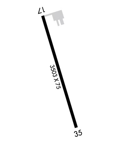
| Lat: N 4650.7 Long: W 08922.0 Elev: 665. Var: +03 Longest Runway: 3503 | ||
| CTAF: 122.9 | ||
| ||||||
|
| Rwy | Rwy | |||||||
| 3503x75 | 3503' | 3503x75 | 3503' | |||||
| Runway ID | Single Wheel | Double Wheel | Double Tandem Wheel | Dual Double Wheel |
| 17/35 | 12,000 | N/A | N/A | N/A |
| These numbers are Advisory and are not limits. The Airport Manager should have more accurate Weight Limits | ||||
 Airport Diagram might not be current. | |
| Facility Name: | ONTONAGON COUNTY - SCHUSTER FLD |
| City Name: | ONTONAGON |
| County: | ONTONAGON |
| State abbrev: | MI |
| State Name: | MICHIGAN |
| Ownership: | PUBLICLY OWNED |
| Use: | OPEN TO THE PUBLIC |
| Owner's Name: | ONTONAGON COUNTY |
| Address: | COURTHOUSE, 725 GREENLAND RD |
| ONTONAGON, MI 49953-1400 | |
| Owner's Phone: | 906-884-4255 |
| Manager's Name: | LISA LINNA |
| Address: | 35932 AIRPORT RD |
| ONTONAGON, MI 49953-9036 | |
| Phone: | 906-884-6214; CELL 906-390-0027. |
| FAA Region: | GREAT LAKES |
| FAA Field Office: | DET |
| Date | Sunrise | Sunset |
|---|---|---|
| 09/24/21 Friday | 7:47 | 19:52 |
| 09/25/21 Saturday | 7:48 | 19:50 |
| 09/26/21 Sunday | 7:49 | 19:48 |
| 09/27/21 Monday | 7:51 | 19:46 |
| 09/28/21 Tuesday | 7:52 | 19:44 |
| 09/29/21 Wednesday | 7:53 | 19:42 |
| 09/30/21 Thursday | 7:55 | 19:40 |
| 10/01/21 Friday | 7:56 | 19:38 |
| 10/02/21 Saturday | 7:57 | 19:36 |
| 10/03/21 Sunday | 7:59 | 19:34 |
| 10/04/21 Monday | 8:00 | 19:32 |
| 10/05/21 Tuesday | 8:01 | 19:30 |
| 10/06/21 Wednesday | 8:03 | 19:28 |
| 10/07/21 Thursday | 8:04 | 19:26 |
| Airport Attendance Schedule | UNATTENDED |
| Airport Status | OPERATIONAL (This Status can change at any time - please check NOTAMS) |
| Airport Lighting Schedule | LGTS OPR CONSLY DUSK-2300. AFT 2300 ACTVT REIL RWY 17 & 35; PAPI RWY 17 & 35; MIRL RWY 17/35 - CTAF. |
| Airport Storage Available | Tie Downs |
| Extra Services Available | NONE |
| Wind Indicator | YES - (lighted) |
| Control Tower | NO |
| CTAF Frequency | 122.900 |
| Unicom Frequency | |
| Rotating Beacon Color | CLEAR-GREEN (Light Land Airport) |
| Segmented Circle | YES |
| Landing Fee | NO |
| Airport Inspected | STATE - performed by STATE AERONAUTICAL PERSONNEL |
| Inspection Date | 09/03/2020 |
| Type of Fuel Available | Grade 100LL; -10AVBL H24 SELF SVC WITH VISA OR MASTERCARD. |
| Airframe Repair Service | NONE |
| Power Plant Repair Service | NONE |
| Latitude | N4650.7 |
| Longitude | W08922.0 (ESTIMATED) |
| Arpt Elevation | 665ft (SURVEYED) |
| Magnetic Variation | 03W |
| 3 miles W | of ONTONAGON |
| Traffic Pattern Altitude | |
| Sectional Chart | GREEN BAY |
| Operations (Reported) | Yearly | Avg. Daily |
|---|---|---|
| General Aviation Transient | 0 | 0 |
| General Aviation Local | 100 | 0 |
| Air Taxi | 0 | 0 |
| Commerical | 0 | 0 |
| Commuter | 0 | 0 |
| Military | 0 | 0 |
| Aircraft based on Field | |
|---|---|
| General Aviation Singles | 6 |
| General Aviation Multi | 0 |
| Jet Aircraft | 0 |
| General Aviation Helicopters | 0 |
| Military Aircraft | 0 |
| Gliders | 0 |
| Ultralights | 0 |
| FSS on field | NO |
| FSS tie-in | GREEN BAY |
| FSS Phone | 1-800-WX-BRIEF |
| Who issues Notams | GRB |
| Notam D service at airport | YES |
| ARTCC Name | MINNEAPOLIS |
| Airport Certification | |
| Aircraft Rescue & Firefighting Index | None |
| Airport of Entry | No |
| Custom Landing Rights | No |
| Joint Civil/Military | No |
| Military Landing rights | YES |
| NATIONAL PLAN OF INTEGRATED AIRPORT SYSTEMS (NPIAS) |
| GRANT AGREEMENTS UNDER FAAP/ADAP/AIP |
| ASSURANCES PURSUANT TO TITLE VI, CIVIL RIGHTS ACT OF 1964 |
| DEER & BIRDS ON & INVOF ARPT. |
| FOR CD CTC MINNEAPOLIS ARTCC AT 651-463-5588. |
Airport Communications & Frequencies:
| |||||||
| Runway: 17 | Runway: 35 | ||
| Mag heading: | 166° | Mag heading: | 346° |
| Rwy Slope: | .73% Up | Rwy Slope: | -.73% Down |
| Approach: | Approach: | ||
| Pattern: | Left Traffic | Pattern: | Left Traffic |
| Markings: | NONPRECISION INSTRUMENT | Markings: | NONPRECISION INSTRUMENT |
| Marking Condition: | GOOD | Marking Condition: | GOOD |
| Arresting Dev: | Arresting Dev: | ||
| Lat & Long: | N4651.0 W08922.1 | Lat. & Long.: | N4650.5 W08921.9 |
| Elev: | 639.5 ft. MSL | Elev: | 665.2 ft. MSL |
| TCH: | 25 ft. AGL | TCH: | 25 ft. AGL |
| Visual Glide Path: | 3.50 degrees | Visual Glide Path: | 3.50 degrees |
| Displaced Threshold: | No | Displaced Threshold: | No |
| Touchdown Zone: | YES | Touchdown Zone: | YES |
| Touchdown Elev.: | 661.0 feet | Touchdown Elev.: | 665.2 feet |
| Visual Glide Slope: | 2-Light PAPI on LEFT side of Runway | Visual Glide Slope: | 2-Light PAPI on LEFT side of Runway |
| RVR Equipment: | RVR Equipment: | ||
| RVV Equipment: | NO | RVV Equipment: | NO |
| Approach Lights: | Approach Lights: | ||
| REIL: | YES | REIL: | YES |
| Centerline Lights: | NO | Centerline Lights: | NO |
| Touchdown lights: | NO | Touchdown lights: | NO |
| Runway Category: | Runway with a Visual Approach | Runway Category: | Runway with a Non-precision Approach |
| Declared Distances: | Declared Distances: | ||
| Obstructions: | TREES | Obstructions: | TREES |
| Marked: | NOT Marked/Lighted | Marked: | NOT Marked/Lighted |
| Clearance slope: | Clearance slope: | 1:1 | |
| Obstruction height: | 11 feet AGL | Obstruction height: | 30 feet AGL |
| Dist. from runway: | 200 feet | Dist. from runway: | 230 feet |
| Centerline offset: | 230 right of centerline | Centerline offset: | 150 feet left of centerline |
| Comments: | 8 FT BRUSH, 105 FT DIST, 110 FT R; 11 FT TREES, 150-199 FT DIST, 230 FT R. | Comments: | 10 FT BRUSH, 0-180 FT DIST, 130 FT L. |
Thanks for using FltPlan.com
all rights reserved © 1999-2021 by Flight Plan LLC
