
| COLUMBIA COLUMBIA CA |
| |
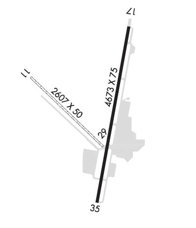
| Lat: N 3801.8 Long: W 12024.9 Elev: 2121 Var: -16 Longest Runway: 4673 | ||
| AWOS: 124.65 CTAF: 122.97 | ||
| ||||||||||||||||||||||||||||||||||||||||||||
| ||||||||||||||||||||||||||||||||||||||||||||
| ||||||||||||||||||||||||||||||||||||||||||||
| Rwy | Rwy | |||||||
| 2607x50 | 2607' | 2607x50 | 2607' | |||||
| 4673x75 | 4075' | 4673x75 | 4289' | |||||
| Runway ID | Single Wheel | Double Wheel | Double Tandem Wheel | Dual Double Wheel |
| 11/29 | N/A | N/A | N/A | N/A |
| 17/35 | 30,000 | N/A | N/A | N/A |
| These numbers are Advisory and are not limits. The Airport Manager should have more accurate Weight Limits | ||||
 Airport Diagram might not be current. | |
| Facility Name: | COLUMBIA |
| City Name: | COLUMBIA |
| County: | TUOLUMNE |
| State abbrev: | CA |
| State Name: | CALIFORNIA |
| Ownership: | PUBLICLY OWNED |
| Use: | OPEN TO THE PUBLIC |
| Owner's Name: | COUNTY OF TUOLUMNE |
| Address: | 2 SOUTH GREEN ST. |
| SONORA, CA 95370 | |
| Owner's Phone: | 209-533-5685 |
| Manager's Name: | BENEDICT STUTH |
| Address: | 10723 AIRPORT RD |
| COLUMBIA, CA 95310 | |
| Phone: | (209) 533-6684 |
| FAA Region: | WESTERN-PACIFIC |
| FAA Field Office: | SFO |

| Date | Sunrise | Sunset |
|---|---|---|
| 09/24/21 Friday | 6:51 | 18:56 |
| 09/25/21 Saturday | 6:52 | 18:54 |
| 09/26/21 Sunday | 6:53 | 18:53 |
| 09/27/21 Monday | 6:54 | 18:51 |
| 09/28/21 Tuesday | 6:55 | 18:49 |
| 09/29/21 Wednesday | 6:55 | 18:48 |
| 09/30/21 Thursday | 6:56 | 18:46 |
| 10/01/21 Friday | 6:57 | 18:45 |
| 10/02/21 Saturday | 6:58 | 18:43 |
| 10/03/21 Sunday | 6:59 | 18:42 |
| 10/04/21 Monday | 7:00 | 18:40 |
| 10/05/21 Tuesday | 7:01 | 18:39 |
| 10/06/21 Wednesday | 7:02 | 18:37 |
| 10/07/21 Thursday | 7:03 | 18:36 |
| Airport Attendance Schedule | 7 Days A Week 0800-1700 |
| Airport Status | OPERATIONAL (This Status can change at any time - please check NOTAMS) |
| Airport Lighting Schedule | ACTVT MIRL RY 17/35 & REIL RYS 17 & 35 - CTAF. VASI RY 17 & RY 35 OPER CONTINUOUSLY. |
| Airport Storage Available | Tie Downs |
| Extra Services Available | Air Freight, Charter, Flight Instruction, Aircraft Rental, Aircraft Sales |
| Wind Indicator | YES - (lighted) |
| Control Tower | NO |
| CTAF Frequency | 122.975 |
| Unicom Frequency | 122.975 |
| Rotating Beacon Color | CLEAR-GREEN (Light Land Airport); ARPT HAS TWO ROTG BCNS; ONE ON THE ARPT AND ONE 6500' SE THR RWY 35. |
| Segmented Circle | YES |
| Landing Fee | YES |
| Airport Inspected | STATE - performed by STATE AERONAUTICAL PERSONNEL |
| Inspection Date | 01/07/2021 |
| Type of Fuel Available | Grade 100LL, JET A (freeze point -40C) |
| Airframe Repair Service | MAJOR |
| Power Plant Repair Service | MAJOR |
| Latitude | N3801.8 |
| Longitude | W12024.9 (ESTIMATED) |
| Arpt Elevation | 2120ft (SURVEYED) |
| Magnetic Variation | 16E |
| 1 miles SW | of COLUMBIA |
| Traffic Pattern Altitude | TPA RWY 11/29 800 FT AGL. |
| Sectional Chart | SAN FRANCISCO |
| Operations (Reported) | Yearly | Avg. Daily |
|---|---|---|
| General Aviation Transient | 22900 | 63 |
| General Aviation Local | 21000 | 58 |
| Air Taxi | 1740 | 5 |
| Commerical | 0 | 0 |
| Commuter | 0 | 0 |
| Military | 17 | 0 |
| Aircraft based on Field | |
|---|---|
| General Aviation Singles | 95 |
| General Aviation Multi | 7 |
| Jet Aircraft | 0 |
| General Aviation Helicopters | 1 |
| Military Aircraft | 0 |
| Gliders | 0 |
| Ultralights | 0 |
| FSS on field | NO |
| FSS tie-in | RANCHO MURIETA |
| FSS Phone | 1-800-WX-BRIEF |
| Who issues Notams | RIU |
| Notam D service at airport | YES |
| ARTCC Name | OAKLAND |
| Airport Certification | |
| Aircraft Rescue & Firefighting Index | None |
| Airport of Entry | No |
| Custom Landing Rights | No |
| Joint Civil/Military | No |
| Military Landing rights | YES |
| NATIONAL PLAN OF INTEGRATED AIRPORT SYSTEMS (NPIAS) |
| GRANT AGREEMENTS UNDER FAAP/ADAP/AIP |
| ASSURANCES PURSUANT TO TITLE VI, CIVIL RIGHTS ACT OF 1964 |
| CALFIRE AIR TANKER OPRS FM ARPT DRG FIRE SEASON. |
| LANDING FEE FOR ALL COMMERCIAL OPERATORS REGARDLESS OF SIZE & CORPORATE ACFT OVER 12500 LBS GROSS LANDING WEIGHT. |
| HEL PRKNG AREA 300 FT BY 120 FT (4 POSITIONS). |
| AVOID FLIGHTS OVER COLUMBIA STATE PARK NE OF ARPT, AND HWY 49 BRIDGE 5 NM SW OF ARPT & VICINITY. |
| FOR CD CTC NORCAL APCH AT 916-361-0516. |
| VARYING WIND DIRECTION & VELOCITY MAY BE ENCOUNTERED AT MID POINT OF RY 17/35 DUE TO TERRAIN FEATURES & WIND FLOW PATTERNS. |
| RY 11 DEPS PROHIBITED DUE TO CONFLICT WITH MAIN RY. |
| TURF TWY NORTH SIDE OF RY 11/29 NOT RECOMMENDED FOR USE NOV - MAR |
| RY 29 NOT RECOMMENDED FOR USE DURING WINTER MONTHS NOV THROUGH MAR. |
| ALL JET ACFT ARE REQUESTED TO LAND RY 35 & DEPART RY 17 WIND & WEATHER PERMITTING. |
| RWY 17/3 5 RY END SAFETY AREAS NSTD LENGTH; RY 17 210 FT; RY 35 300 FT. |
Airport Communications & Frequencies:
| |||||||||||||||||
| Runway: 11 | Runway: 29 | ||
| Mag heading: | 118° | Mag heading: | 298° |
| Rwy Slope: | -.88% Down | Rwy Slope: | .88% Up |
| Approach: | Approach: | ||
| Pattern: | Right Traffic | Pattern: | Left Traffic |
| Markings: | NONE | Markings: | NUMBERS ONLY |
| Marking Condition: | Marking Condition: | GOOD | |
| Arresting Dev: | Arresting Dev: | ||
| Lat & Long: | N3802.0 W12025.2 | Lat. & Long.: | N3801.7 W12024.8 |
| Elev: | 2100.6 ft. MSL | Elev: | 2077.6 ft. MSL |
| TCH: | TCH: | ||
| Visual Glide Path: | Visual Glide Path: | ||
| Displaced Threshold: | No | Displaced Threshold: | No |
| Touchdown Zone: | YES | Touchdown Zone: | YES |
| Touchdown Elev.: | 2100.6 feet | Touchdown Elev.: | 2100.6 feet |
| Visual Glide Slope: | Visual Glide Slope: | ||
| RVR Equipment: | RVR Equipment: | ||
| RVV Equipment: | NO | RVV Equipment: | NO |
| Approach Lights: | Approach Lights: | ||
| REIL: | NO | REIL: | NO |
| Centerline Lights: | NO | Centerline Lights: | NO |
| Touchdown lights: | NO | Touchdown lights: | NO |
| Runway Category: | Runway with a Visual Approach | Runway Category: | Runway with a Visual Approach |
| Declared Distances: | Declared Distances: | ||
| Obstructions: | TREES | Obstructions: | TREES |
| Marked: | NOT Marked/Lighted | Marked: | NOT Marked/Lighted |
| Clearance slope: | 16:1 | Clearance slope: | 13:1 |
| Obstruction height: | 135 feet AGL | Obstruction height: | 115 feet AGL |
| Dist. from runway: | 2190 feet | Dist. from runway: | 1600 feet |
| Centerline offset: | 125 left of centerline | Centerline offset: | 100 feet right of centerline |
| Comments: | Comments: |
| Runway: 17 | Runway: 35 | ||
| Mag heading: | 174° | Mag heading: | 354° |
| Rwy Slope: | -1.01% Down | Rwy Slope: | 1.01% Up |
| Approach: | Approach: | ||
| Pattern: | Right Traffic | Pattern: | Left Traffic |
| Markings: | NONPRECISION INSTRUMENT | Markings: | NONPRECISION INSTRUMENT |
| Marking Condition: | FAIR | Marking Condition: | FAIR |
| Arresting Dev: | Arresting Dev: | ||
| Lat & Long: | N3802.2 W12024.7 | Lat. & Long.: | N3801.4 W12024.9 |
| Elev: | 2120.7 ft. MSL | Elev: | 2073.6 ft. MSL |
| TCH: | 56 ft. AGL | TCH: | 54 ft. AGL |
| Visual Glide Path: | 4.55 degrees | Visual Glide Path: | 4.00 degrees |
| Displaced Threshold: | 598 feet | Displaced Threshold: | 384 feet |
| Touchdown Zone: | YES | Touchdown Zone: | YES |
| Touchdown Elev.: | 2112.2 feet | Touchdown Elev.: | 2104.7 feet |
| Visual Glide Slope: | 2-Box VASI on LEFT side of Runway | Visual Glide Slope: | 2-Box VASI on LEFT side of Runway; RY 35 VASI UNUSABLE BYD 5 DEG LEFT AND RIGHT OF RY CNTRLN. |
| RVR Equipment: | RVR Equipment: | ||
| RVV Equipment: | NO | RVV Equipment: | NO |
| Approach Lights: | Approach Lights: | ||
| REIL: | YES | REIL: | YES |
| Centerline Lights: | NO | Centerline Lights: | NO |
| Touchdown lights: | NO | Touchdown lights: | NO |
| Runway Category: | Runway with a Visual Approach | Runway Category: | Runway with a Non-precision Approach |
| Declared Distances: | Declared Distances: | ||
| Obstructions: | GND | Obstructions: | TREES |
| Marked: | NOT Marked/Lighted | Marked: | NOT Marked/Lighted |
| Clearance slope: | 8:1; APCH RATIO FM DSPLCD THLD 31:1. | Clearance slope: | 24:1; APCH RATIO FM DSPLCD THLD 37:1. |
| Obstruction height: | 33 feet AGL | Obstruction height: | 61 feet AGL |
| Dist. from runway: | 450 feet | Dist. from runway: | 1700 feet |
| Centerline offset: | 125 right of centerline | Centerline offset: | 350 feet right of centerline |
| Comments: | Comments: |
Thanks for using FltPlan.com
all rights reserved © 1999-2021 by Flight Plan LLC