
| LEMOORE NAS (REEVES FLD) LEMOORE CA |
| |
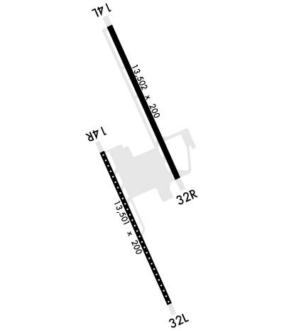
| Lat: N 3620.0 Long: W 11957.1 Elev: 228 Var: -14 Longest Runway: 13502 | ||
| Clr Del: 124.1 Dept. ATIS: 121.57 Arr. ATIS: 121.57 AWOS: 121.57 Ground: 121.65 Tower: 128.3 | ||
| ||||||||||||||||||||||||||||||||
| ||||||||||||||||||||||||||||||||
| ||||||||||||||||||||||||||||||||
| Rwy | Rwy | |||||||
| 13502x200 | 13502' | 13502x200 | 13502' | |||||
| 13501x200 | 13501' | 13501x200 | 13501' | |||||
| Runway ID | Single Wheel | Double Wheel | Double Tandem Wheel | Dual Double Wheel |
| 14L/32R | N/A | N/A | N/A | N/A |
| 14R/32L | N/A | N/A | N/A | N/A |
| These numbers are Advisory and are not limits. The Airport Manager should have more accurate Weight Limits | ||||
 Airport Diagram might not be current. | |
| Facility Name: | LEMOORE NAS (REEVES FLD) |
| City Name: | LEMOORE |
| County: | KINGS |
| State abbrev: | CA |
| State Name: | CALIFORNIA |
| Ownership: | NAVY OWNED |
| Use: | PRIVATE |
| Owner's Name: | US NAVY |
| Address: | OCEANOGRAPHIC OFC - CODE 3142 |
| WASHINGTON, DC 20373 | |
| Owner's Phone: | |
| Manager's Name: | COMMANDING OFFICER |
| Address: | NAVAL AIR STATION |
| LEMOORE, CA 93245 | |
| Phone: | |
| FAA Region: | WESTERN-PACIFIC |
| FAA Field Office: | SFO |
| Date | Sunrise | Sunset |
|---|---|---|
| 09/24/21 Friday | 6:49 | 18:54 |
| 09/25/21 Saturday | 6:50 | 18:52 |
| 09/26/21 Sunday | 6:51 | 18:51 |
| 09/27/21 Monday | 6:52 | 18:49 |
| 09/28/21 Tuesday | 6:52 | 18:48 |
| 09/29/21 Wednesday | 6:53 | 18:46 |
| 09/30/21 Thursday | 6:54 | 18:45 |
| 10/01/21 Friday | 6:55 | 18:44 |
| 10/02/21 Saturday | 6:56 | 18:42 |
| 10/03/21 Sunday | 6:56 | 18:41 |
| 10/04/21 Monday | 6:57 | 18:39 |
| 10/05/21 Tuesday | 6:58 | 18:38 |
| 10/06/21 Wednesday | 6:59 | 18:36 |
| 10/07/21 Thursday | 7:00 | 18:35 |
| Airport Attendance Schedule | MON-FRI 1600-0800Z++, SAT-SUN 1800-0200Z++; FIELD HOURS SUBJECT TO CHANGE VIA NOTAM. SEE FLIP AP/1 SUPPLEMENTARY ARPT |
| Airport Status | OPERATIONAL (This Status can change at any time - please check NOTAMS) |
| Airport Lighting Schedule | AVBL ONLY DURING HRS OF OPERATION.; ROT BCN NOT OPR WHEN ARPT CLSD. |
| Airport Storage Available | NONE |
| Extra Services Available | NONE |
| Wind Indicator | NONE |
| Control Tower | YES |
| CTAF Frequency | |
| Unicom Frequency | |
| Rotating Beacon Color | SPLIT-CLEAR-GREEN (LIGHTED MILITARY AIRPORT) |
| Segmented Circle | NO |
| Landing Fee |
| Airport Inspected | No Inspection Data Available performed by the OWNER |
| Inspection Date | Unknown |
| Type of Fuel Available | None |
| Airframe Repair Service | NONE |
| Power Plant Repair Service | NONE |
| Latitude | N3620.0 |
| Longitude | W11957.1 (ESTIMATED) |
| Arpt Elevation | 228ft (SURVEYED) |
| Magnetic Variation | 14E |
| 7 miles W | of LEMOORE |
| Traffic Pattern Altitude | |
| Sectional Chart | SAN FRANCISCO |
| Operations (Reported) | Yearly | Avg. Daily |
|---|---|---|
| General Aviation Transient | 0 | 0 |
| General Aviation Local | 0 | 0 |
| Air Taxi | 0 | 0 |
| Commerical | 0 | 0 |
| Commuter | 0 | 0 |
| Military | 0 | 0 |
| Aircraft based on Field | |
|---|---|
| General Aviation Singles | 0 |
| General Aviation Multi | 0 |
| Jet Aircraft | 0 |
| General Aviation Helicopters | 0 |
| Military Aircraft | 0 |
| Gliders | 0 |
| Ultralights | 0 |
| FSS on field | NO |
| FSS tie-in | RANCHO MURIETA |
| FSS Phone | 1-800-WX-BRIEF |
| Who issues Notams | NLC |
| Notam D service at airport | YES |
| ARTCC Name | OAKLAND |
| Airport Certification | |
| Aircraft Rescue & Firefighting Index | None |
| Airport of Entry | No |
| Custom Landing Rights | No |
| Joint Civil/Military | No |
| Military Landing rights | No |
| FLUID: SP PRESAIR OXRB (LOX AVBL 1600-2400Z++ MON-FRI ONLY.) |
| TRAN ALERT: LTD TRAN SVC/MAINT AVBL DUR ARPT OPR HR. HI-SPEED FUEL LANES NOT AVBL TO TRAN ACFT. |
| RSTD: PPR DSN 949-1023, C559-998-1023 EXC AIREVAC. CIV ACFT LDG PERMS RQR. PRIOR COORD OR FLT ADVSY RQR FOR AMC AND SKED AIRLIFTS. 24 HR PN RQR FOR ACFT WITH HAZ CARGO. |
| CAUTION: BIRD HAZ. HI INTS JET OPR 25 NM RAD 0-15,000' MON-FRI. BLACK TOP AREAS ADJ TO TWY AND HGR FOR EROSION CTL ONLY, WILL NOT SUPPORT ACFT. |
| TFC PAT: HVY ACFT EXECUTING PRACTICE INST APCH LTD TO LO APCH. REDUCED RWY SEPARATION STD IN EFF USN/USMC ACFT. |
| OIL: O-128-133-156. |
| SERVICE LGT - CARRIER DECK LGT RWY 14L AND RWY 32L |
| MISC: PRIOR COORD REQ FOR PRACTICE INST APCH DSN 949-1099 C559-998-1099. |
| JASU: 2(GTC-85) 2(NC-5) 2(NC-8) 1(NCPP-105). |
| FUEL: J5. |
Airport Communications & Frequencies:
| |||||||||||||||||||||||||||||||||||||||
| Runway: 14L | Runway: 32R | ||
| Mag heading: | 142° | Mag heading: | 322° |
| Rwy Slope: | .04% Up | Rwy Slope: | -.04% Down |
| Approach: | Approach: | ||
| Pattern: | Left Traffic | Pattern: | Left Traffic |
| Markings: | Markings: | ||
| Marking Condition: | Marking Condition: | ||
| Arresting Dev: | E28; HOOK E28(B) (1849') | Arresting Dev: | E28; HOOK E28(B) (1756') |
| Lat & Long: | N3621.8 W11957.6 | Lat. & Long.: | N3619.8 W11956.5 |
| Elev: | 216.2 ft. MSL | Elev: | 221.0 ft. MSL |
| TCH: | TCH: | ||
| Visual Glide Path: | Visual Glide Path: | ||
| Displaced Threshold: | No | Displaced Threshold: | No |
| Touchdown Zone: | YES | Touchdown Zone: | YES |
| Touchdown Elev.: | 218.9 feet | Touchdown Elev.: | 221.4 feet |
| Visual Glide Slope: | Visual Glide Slope: | ||
| RVR Equipment: | RVR Equipment: | ||
| RVV Equipment: | NO | RVV Equipment: | NO |
| Approach Lights: | OLS | Approach Lights: | OLS |
| REIL: | YES | REIL: | YES |
| Centerline Lights: | NO | Centerline Lights: | NO |
| Touchdown lights: | NO | Touchdown lights: | NO |
| Runway Category: | Runway Category: | ||
| Declared Distances: | Declared Distances: |
| Runway: 14R | Runway: 32L | ||
| Mag heading: | 142° | Mag heading: | 322° |
| Rwy Slope: | -.01% Down | Rwy Slope: | .01% Up |
| Approach: | Approach: | ||
| Pattern: | Left Traffic | Pattern: | Left Traffic |
| Markings: | Markings: | ||
| Marking Condition: | Marking Condition: | ||
| Arresting Dev: | E28; HOOK E28(B) (1600') | Arresting Dev: | E28; HOOK E28(B) (3495') |
| Lat & Long: | N3620.2 W11957.7 | Lat. & Long.: | N3618.1 W11956.6 |
| Elev: | 227.0 ft. MSL | Elev: | 225.7 ft. MSL |
| TCH: | TCH: | ||
| Visual Glide Path: | Visual Glide Path: | ||
| Displaced Threshold: | No | Displaced Threshold: | No |
| Touchdown Zone: | YES | Touchdown Zone: | YES |
| Touchdown Elev.: | 227.9 feet | Touchdown Elev.: | 227.0 feet |
| Visual Glide Slope: | Visual Glide Slope: | ||
| RVR Equipment: | RVR Equipment: | ||
| RVV Equipment: | NO | RVV Equipment: | NO |
| Approach Lights: | OLS | Approach Lights: | ALSF2 - standard 2,400 foot high intensity approach lighting system with sequenced flashers, Category II or III; SF, OLS, WAVE-OFF |
| REIL: | YES | REIL: | YES |
| Centerline Lights: | YES | Centerline Lights: | YES |
| Touchdown lights: | NO | Touchdown lights: | NO |
| Runway Category: | Runway Category: | ||
| Declared Distances: | Declared Distances: |
Thanks for using FltPlan.com
all rights reserved © 1999-2021 by Flight Plan LLC
