
| STORMVILLE STORMVILLE NY |
| |
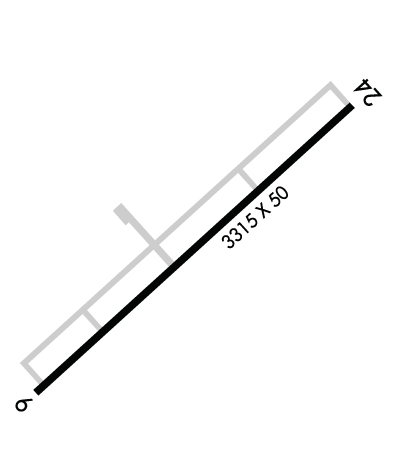
| Lat: N 4134.6 Long: W 07343.9 Elev: 358 Var: +12 Longest Runway: 3315 | ||
| CTAF: 122.8 | ||
| ||||||||||||||||||||||||||||||||
| ||||||||||||||||||||||||||||||||
| Rwy | Rwy | |||||||
| 3315x50 | 3315' | 3315x50 | 3315' | |||||
| Runway ID | Single Wheel | Double Wheel | Double Tandem Wheel | Dual Double Wheel |
| 06/24 | 25,000 | N/A | N/A | N/A |
| These numbers are Advisory and are not limits. The Airport Manager should have more accurate Weight Limits | ||||
| FltPlan does not have IFR approach charts available for KN69. |
 Airport Diagram might not be current. | |
| Facility Name: | STORMVILLE |
| City Name: | STORMVILLE |
| County: | DUTCHESS |
| State abbrev: | NY |
| State Name: | NEW YORK |
| Ownership: | PRIVATELY OWNED |
| Use: | OPEN TO THE PUBLIC |
| Owner's Name: | TOM CARNAHAN |
| Address: | PO BOX 85 |
| STORMVILLE, NY 12582 | |
| Owner's Phone: | 845-221-6561 |
| Manager's Name: | SEAN BOGART |
| Address: | 725 ROUTE 216 |
| POUGHQUAG, NY 12570 | |
| Phone: | (845) 227-4444 |
| FAA Region: | EASTERN |
| FAA Field Office: | NYC |
| Date | Sunrise | Sunset |
|---|---|---|
| 09/24/21 Friday | 6:44 | 18:49 |
| 09/25/21 Saturday | 6:45 | 18:47 |
| 09/26/21 Sunday | 6:46 | 18:46 |
| 09/27/21 Monday | 6:47 | 18:44 |
| 09/28/21 Tuesday | 6:48 | 18:42 |
| 09/29/21 Wednesday | 6:49 | 18:41 |
| 09/30/21 Thursday | 6:50 | 18:39 |
| 10/01/21 Friday | 6:51 | 18:37 |
| 10/02/21 Saturday | 6:52 | 18:35 |
| 10/03/21 Sunday | 6:54 | 18:34 |
| 10/04/21 Monday | 6:55 | 18:32 |
| 10/05/21 Tuesday | 6:56 | 18:30 |
| 10/06/21 Wednesday | 6:57 | 18:29 |
| 10/07/21 Thursday | 6:58 | 18:27 |
| Airport Attendance Schedule | UNATTENDED |
| Airport Status | OPERATIONAL (This Status can change at any time - please check NOTAMS) |
| Airport Lighting Schedule | |
| Airport Storage Available | Tie Downs |
| Extra Services Available | NONE |
| Wind Indicator | YES - (unlit) |
| Control Tower | NO |
| CTAF Frequency | 122.800 |
| Unicom Frequency | 122.800 |
| Rotating Beacon Color | |
| Segmented Circle | NO |
| Landing Fee | NO |
| Airport Inspected | STATE - performed by STATE AERONAUTICAL PERSONNEL |
| Inspection Date | 07/19/2018 |
| Type of Fuel Available | None |
| Airframe Repair Service | NONE |
| Power Plant Repair Service | NONE |
| Latitude | N4134.6 |
| Longitude | W07343.9 (ESTIMATED) |
| Arpt Elevation | 358ft (SURVEYED) |
| Magnetic Variation | 12W |
| 1 miles NE | of STORMVILLE |
| Traffic Pattern Altitude | |
| Sectional Chart | NEW YORK |
| Operations (Reported) | Yearly | Avg. Daily |
|---|---|---|
| General Aviation Transient | 200 | 1 |
| General Aviation Local | 200 | 1 |
| Air Taxi | 0 | 0 |
| Commerical | 0 | 0 |
| Commuter | 0 | 0 |
| Military | 0 | 0 |
| Aircraft based on Field | |
|---|---|
| General Aviation Singles | 0 |
| General Aviation Multi | 0 |
| Jet Aircraft | 0 |
| General Aviation Helicopters | 0 |
| Military Aircraft | 0 |
| Gliders | 0 |
| Ultralights | 0 |
| FSS on field | NO |
| FSS tie-in | NEW YORK |
| FSS Phone | 1-800-WX-BRIEF |
| Who issues Notams | ISP |
| Notam D service at airport | YES |
| ARTCC Name | NEW YORK |
| Airport Certification | |
| Aircraft Rescue & Firefighting Index | None |
| Airport of Entry | No |
| Custom Landing Rights | No |
| Joint Civil/Military | No |
| Military Landing rights | No |
| GEESE ON & INVOF RWY. |
| FOR CD CTC NEW YORK APCH AT 516-683-2448. |
| RWY 06/2 4 NOT PLOWED. FLEE MARKET OBSTNS & MATERIAL MAY BE NEXT TO RWY ENDS. |
| RWY 06/2 4 WIDE CRACKS & WEEDS ON RWY. |
Airport Communications & Frequencies:
| ||||||||||||||
| Runway: 06 | Runway: 24 | ||
| Mag heading: | 58° | Mag heading: | 238° |
| Rwy Slope: | .75% Up | Rwy Slope: | -.75% Down |
| Approach: | Approach: | ||
| Pattern: | Left Traffic | Pattern: | Left Traffic |
| Markings: | NONE | Markings: | NONE |
| Marking Condition: | POOR | Marking Condition: | POOR |
| Arresting Dev: | Arresting Dev: | ||
| Lat & Long: | N4134.4 W07344.2 | Lat. & Long.: | N4134.8 W07343.7 |
| Elev: | 326.0 ft. MSL | Elev: | 351.0 ft. MSL |
| TCH: | TCH: | ||
| Visual Glide Path: | Visual Glide Path: | ||
| Displaced Threshold: | No | Displaced Threshold: | No |
| Touchdown Zone: | YES | Touchdown Zone: | YES |
| Touchdown Elev.: | 358.0 feet | Touchdown Elev.: | 358.0 feet |
| Visual Glide Slope: | Visual Glide Slope: | ||
| RVR Equipment: | RVR Equipment: | ||
| RVV Equipment: | NO | RVV Equipment: | NO |
| Approach Lights: | Approach Lights: | ||
| REIL: | NO | REIL: | NO |
| Centerline Lights: | NO | Centerline Lights: | NO |
| Touchdown lights: | NO | Touchdown lights: | NO |
| Runway Category: | Runway with a Visual Approach | Runway Category: | Runway with a Visual Approach |
| Declared Distances: | Declared Distances: | ||
| Obstructions: | TREES | Obstructions: | |
| Marked: | NOT Marked/Lighted | Marked: | |
| Clearance slope: | Clearance slope: | 20:1 | |
| Obstruction height: | 60 feet AGL | Obstruction height: | |
| Dist. from runway: | 200 feet | Dist. from runway: | |
| Centerline offset: | Centerline offset: | ||
| Comments: | 65 FT TREES 30-105 FT RIGHT & 55-129 FT LEFT OF RWY END. | Comments: | +10 FT GRVL RDS 25 FT FM THR; 3 FT BERM PARELLEL TO 3RD ROAD 75 FT FM THR. |
Thanks for using FltPlan.com
all rights reserved © 1999-2021 by Flight Plan LLC
