
| MANKATO RGNL MANKATO MN |
| |
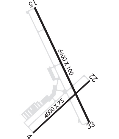
| Lat: N 4413.4 Long: W 09355.2 Elev: 1021 Var: -04 Longest Runway: 6600 | ||
| AWOS: 118.17 CTAF: 122.72 | ||
| ||||||||||||||||||||||||||||||||||||||||||||
| ||||||||||||||||||||||||||||||||||||||||||||
| ||||||||||||||||||||||||||||||||||||||||||||
| Rwy | Rwy | |||||||
| 4000x75 | 4000' | 4000x75 | 4000' | |||||
| 6600x100 | 6600' | 6600x100 | 6600' | 108.70 - 330° | ||||
| Runway ID | Single Wheel | Double Wheel | Double Tandem Wheel | Dual Double Wheel |
| 04/22 | 18,000 | 25,000 | N/A | N/A |
| 15/33 | 60,000 | 120,000 | 155,000 | 237,000 |
| These numbers are Advisory and are not limits. The Airport Manager should have more accurate Weight Limits | ||||
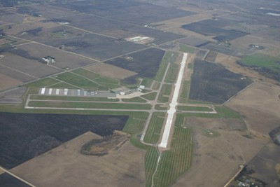
 Airport Diagram might not be current. | |
| Facility Name: | MANKATO RGNL |
| City Name: | MANKATO |
| County: | BLUE EARTH |
| State abbrev: | MN |
| State Name: | MINNESOTA |
| Ownership: | PUBLICLY OWNED |
| Use: | OPEN TO THE PUBLIC |
| Owner's Name: | CITY OF MANKATO |
| Address: | 10 CIVIC CENTER PLAZA, P.O. BOX 3368 |
| MANKATO, MN 56001 | |
| Owner's Phone: | 507-387-8600 |
| Manager's Name: | JOE GRABIANOWSKI |
| Address: | 3030 AIRPORT ROAD |
| MANKATO, MN 56001 | |
| Phone: | 507-380-3880 |
| FAA Region: | GREAT LAKES |
| FAA Field Office: | DMA |
| Date | Sunrise | Sunset |
|---|---|---|
| 09/24/21 Friday | 7:05 | 19:10 |
| 09/25/21 Saturday | 7:06 | 19:08 |
| 09/26/21 Sunday | 7:07 | 19:06 |
| 09/27/21 Monday | 7:08 | 19:04 |
| 09/28/21 Tuesday | 7:10 | 19:02 |
| 09/29/21 Wednesday | 7:11 | 19:00 |
| 09/30/21 Thursday | 7:12 | 18:59 |
| 10/01/21 Friday | 7:13 | 18:57 |
| 10/02/21 Saturday | 7:14 | 18:55 |
| 10/03/21 Sunday | 7:16 | 18:53 |
| 10/04/21 Monday | 7:17 | 18:51 |
| 10/05/21 Tuesday | 7:18 | 18:50 |
| 10/06/21 Wednesday | 7:19 | 18:48 |
| 10/07/21 Thursday | 7:20 | 18:46 |
| Airport Attendance Schedule | MON-FRI 0700-2000, SAT-SUN 0800-1900 |
| Airport Status | OPERATIONAL (This Status can change at any time - please check NOTAMS) |
| Airport Lighting Schedule | ACTIVATE MALSR RWY 33; REIL RWY 04, 15 & 22; PAPI RWY 04, 15, 22 & 33; MIRL RWY 04/22; HIRL RWY 15/33 - CTAF. |
| Airport Storage Available | Tie Downs, Hanger |
| Extra Services Available | Charter, Flight Instruction, Aircraft Rental, Aircraft Sales |
| Wind Indicator | YES - (lighted) |
| Control Tower | NO |
| CTAF Frequency | 122.725 |
| Unicom Frequency | 122.725 |
| Rotating Beacon Color | CLEAR-GREEN (Light Land Airport) |
| Segmented Circle | YES |
| Landing Fee | NO |
| Airport Inspected | FEDERAL - performed by STATE AERONAUTICAL PERSONNEL |
| Inspection Date | 07/16/2018 |
| Type of Fuel Available | Grade 100LL, JET A (freeze point -40C); -A AFT HRS CALL 507-469-0228.; -10100LL AVBL H24 WITH CREDIT CARD. |
| Airframe Repair Service | MAJOR |
| Power Plant Repair Service | MAJOR |
| Latitude | N4413.4 |
| Longitude | W09355.2 (ESTIMATED) |
| Arpt Elevation | 1020ft (SURVEYED) |
| Magnetic Variation | 04E |
| 5 miles NE | of MANKATO |
| Traffic Pattern Altitude | TPA 2000 FT MSL (LT TFC) FOR LIGHT ACFT, 2500 FT MSL (LT TFC) FOR TURBINE ACFT & 2000 FT MSL (RT TFC) FOR ROTORCRAFT ACFT. |
| Sectional Chart | OMAHA |
| Operations (Reported) | Yearly | Avg. Daily |
|---|---|---|
| General Aviation Transient | 45914 | 126 |
| General Aviation Local | 76685 | 210 |
| Air Taxi | 3037 | 8 |
| Commerical | 0 | 0 |
| Commuter | 0 | 0 |
| Military | 500 | 1 |
| Aircraft based on Field | |
|---|---|
| General Aviation Singles | 78 |
| General Aviation Multi | 12 |
| Jet Aircraft | 2 |
| General Aviation Helicopters | 3 |
| Military Aircraft | 0 |
| Gliders | 2 |
| Ultralights | 0 |
| FSS on field | NO |
| FSS tie-in | PRINCETON |
| FSS Phone | 1-800-WX-BRIEF |
| Who issues Notams | MKT |
| Notam D service at airport | YES |
| ARTCC Name | MINNEAPOLIS |
| Airport Certification | |
| Aircraft Rescue & Firefighting Index | None |
| Airport of Entry | No |
| Custom Landing Rights | No |
| Joint Civil/Military | No |
| Military Landing rights | YES |
| NATIONAL PLAN OF INTEGRATED AIRPORT SYSTEMS (NPIAS) |
| GRANT AGREEMENTS UNDER FAAP/ADAP/AIP |
| ASSURANCES PURSUANT TO TITLE VI, CIVIL RIGHTS ACT OF 1964 |
| DEER & MIGRATORY WATERFOWL ON & INVOF ARPT. |
| INTENSIVE FLIGHT TRAINING |
| FBO AVBL ON 123.5. |
| RWY 33 CALM WIND RWY. |
Airport Communications & Frequencies:
| |||||||||
| Runway: 04 | Runway: 22 | ||
| Mag heading: | 43° | Mag heading: | 223° |
| Rwy Slope: | .31% Up | Rwy Slope: | -.31% Down |
| Approach: | Approach: | ||
| Pattern: | Left Traffic | Pattern: | Left Traffic |
| Markings: | NONPRECISION INSTRUMENT | Markings: | NONPRECISION INSTRUMENT |
| Marking Condition: | GOOD | Marking Condition: | GOOD |
| Arresting Dev: | Arresting Dev: | ||
| Lat & Long: | N4412.9 W09355.5 | Lat. & Long.: | N4413.4 W09354.8 |
| Elev: | 1007.2 ft. MSL | Elev: | 1019.7 ft. MSL |
| TCH: | 39 ft. AGL | TCH: | 26 ft. AGL |
| Visual Glide Path: | 3.00 degrees | Visual Glide Path: | 3.00 degrees |
| Displaced Threshold: | No | Displaced Threshold: | No |
| Touchdown Zone: | YES | Touchdown Zone: | YES |
| Touchdown Elev.: | 1017.9 feet | Touchdown Elev.: | 1020.8 feet |
| Visual Glide Slope: | 4-Light PAPI on LEFT side of Runway | Visual Glide Slope: | 4-Light PAPI on LEFT side of Runway |
| RVR Equipment: | RVR Equipment: | ||
| RVV Equipment: | NO | RVV Equipment: | NO |
| Approach Lights: | Approach Lights: | ||
| REIL: | YES | REIL: | YES |
| Centerline Lights: | NO | Centerline Lights: | NO |
| Touchdown lights: | NO | Touchdown lights: | NO |
| Runway Category: | Runway with a Non-precision Approach having visibility minimums greater than 3/4 mile | Runway Category: | Runway with a Non-precision Approach having visibility minimums greater than 3/4 mile |
| Declared Distances: | Declared Distances: |
| Runway: 15 | Runway: 33 | ||
| Mag heading: | 151° | Mag heading: | 331° |
| Rwy Slope: | .03% Up | Rwy Slope: | -.03% Down |
| Approach: | Approach: | ILS | |
| Pattern: | Left Traffic | Pattern: | Left Traffic |
| Markings: | PRECISION INSTRUMENT | Markings: | PRECISION INSTRUMENT |
| Marking Condition: | GOOD | Marking Condition: | GOOD |
| Arresting Dev: | Arresting Dev: | ||
| Lat & Long: | N4414.0 W09355.5 | Lat. & Long.: | N4413.0 W09354.8 |
| Elev: | 1018.7 ft. MSL | Elev: | 1020.8 ft. MSL |
| TCH: | 48 ft. AGL | TCH: | 49 ft. AGL |
| Visual Glide Path: | 3.00 degrees | Visual Glide Path: | 3.00 degrees |
| Displaced Threshold: | No | Displaced Threshold: | No |
| Touchdown Zone: | YES | Touchdown Zone: | YES |
| Touchdown Elev.: | 1019.8 feet | Touchdown Elev.: | 1020.8 feet |
| Visual Glide Slope: | 4-Light PAPI on LEFT side of Runway | Visual Glide Slope: | 4-Light PAPI on LEFT side of Runway |
| RVR Equipment: | RVR Equipment: | ||
| RVV Equipment: | NO | RVV Equipment: | NO |
| Approach Lights: | Approach Lights: | MALSR - 1,400 foot medium intensity approach lighting system with runway alignment indicator lights | |
| REIL: | YES | REIL: | NO |
| Centerline Lights: | NO | Centerline Lights: | NO |
| Touchdown lights: | NO | Touchdown lights: | NO |
| Runway Category: | Runway with a Non-precision Approach having visibility minimums greater than 3/4 mile | Runway Category: | Precision Instrument Runway |
| Declared Distances: | Declared Distances: | ||
| Comments: | Comments: | 2 FT CROPS 186 FT FROM RWY END 344 FT L. |
Thanks for using FltPlan.com
all rights reserved © 1999-2021 by Flight Plan LLC