
| HARBOR SPRINGS HARBOR SPRINGS MI |
| |
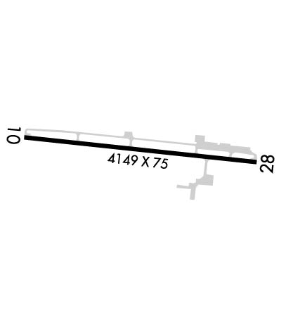
| Lat: N 4525.5 Long: W 08454.8 Elev: 686 Var: +05 Longest Runway: 4149 | ||
| AWOS: 119.92 CTAF: 122.8 | ||
| ||||||
| ||||||
|
| Rwy | Rwy | |||||||
| 4149x75 | 3712' | 4149x75 | 3705' | |||||
| Runway ID | Single Wheel | Double Wheel | Double Tandem Wheel | Dual Double Wheel |
| 10/28 | 22,000 | 30,000 | N/A | N/A |
| These numbers are Advisory and are not limits. The Airport Manager should have more accurate Weight Limits | ||||
 Airport Diagram might not be current. | |
| Facility Name: | HARBOR SPRINGS |
| City Name: | HARBOR SPRINGS |
| County: | EMMET |
| State abbrev: | MI |
| State Name: | MICHIGAN |
| Ownership: | PUBLICLY OWNED |
| Use: | OPEN TO THE PUBLIC |
| Owner's Name: | HARBOR/PETOSKEY AREA AIRPORT AUTHOR |
| Address: | C/O WILLIAM P. DOHM, P. O. BOX 274 |
| CONWAY, MI 49722-0274 | |
| Owner's Phone: | 231-347-2812 |
| Manager's Name: | MARK ZABAWA |
| Address: | 8350 M-119 |
| HARBOR SPRINGS, MI 49740-9595 | |
| Phone: | 231-347-2812 |
| FAA Region: | GREAT LAKES |
| FAA Field Office: | DET |
| Date | Sunrise | Sunset |
|---|---|---|
| 09/24/21 Friday | 7:29 | 19:34 |
| 09/25/21 Saturday | 7:30 | 19:32 |
| 09/26/21 Sunday | 7:31 | 19:30 |
| 09/27/21 Monday | 7:33 | 19:28 |
| 09/28/21 Tuesday | 7:34 | 19:26 |
| 09/29/21 Wednesday | 7:35 | 19:24 |
| 09/30/21 Thursday | 7:36 | 19:22 |
| 10/01/21 Friday | 7:38 | 19:20 |
| 10/02/21 Saturday | 7:39 | 19:18 |
| 10/03/21 Sunday | 7:40 | 19:17 |
| 10/04/21 Monday | 7:41 | 19:15 |
| 10/05/21 Tuesday | 7:43 | 19:13 |
| 10/06/21 Wednesday | 7:44 | 19:11 |
| 10/07/21 Thursday | 7:45 | 19:09 |
| Airport Attendance Schedule | 7 Days A Week 0800-DUSK |
| Airport Status | OPERATIONAL (This Status can change at any time - please check NOTAMS) |
| Airport Lighting Schedule | ACTVT PAPI RY 10 & PAPI RY 28; MIRL RY 10/28 - CTAF. |
| Airport Storage Available | Tie Downs |
| Extra Services Available | NONE |
| Wind Indicator | YES - (lighted) |
| Control Tower | NO |
| CTAF Frequency | 122.800 |
| Unicom Frequency | 122.800 |
| Rotating Beacon Color | CLEAR-GREEN (Light Land Airport) |
| Segmented Circle | NO |
| Landing Fee | YES |
| Airport Inspected | STATE - performed by STATE AERONAUTICAL PERSONNEL |
| Inspection Date | 06/24/2019 |
| Type of Fuel Available | Grade 100LL, JET A (freeze point -40C) |
| Airframe Repair Service | None |
| Power Plant Repair Service | None |
| Latitude | N4525.5 |
| Longitude | W08454.8 (ESTIMATED) |
| Arpt Elevation | 685ft (SURVEYED) |
| Magnetic Variation | 05W |
| 3 miles E | of HARBOR SPRINGS |
| Traffic Pattern Altitude | |
| Sectional Chart | LAKE HURON |
| Operations (Reported) | Yearly | Avg. Daily |
|---|---|---|
| General Aviation Transient | 12000 | 33 |
| General Aviation Local | 4500 | 12 |
| Air Taxi | 0 | 0 |
| Commerical | 0 | 0 |
| Commuter | 0 | 0 |
| Military | 0 | 0 |
| Aircraft based on Field | |
|---|---|
| General Aviation Singles | 17 |
| General Aviation Multi | 1 |
| Jet Aircraft | 1 |
| General Aviation Helicopters | 0 |
| Military Aircraft | 0 |
| Gliders | 0 |
| Ultralights | 0 |
| FSS on field | NO |
| FSS tie-in | LANSING |
| FSS Phone | 1-800-WX-BRIEF |
| Who issues Notams | MGN |
| Notam D service at airport | YES |
| ARTCC Name | MINNEAPOLIS |
| Airport Certification | |
| Aircraft Rescue & Firefighting Index | None |
| Airport of Entry | No |
| Custom Landing Rights | No |
| Joint Civil/Military | No |
| Military Landing rights | No |
| NATIONAL PLAN OF INTEGRATED AIRPORT SYSTEMS (NPIAS) |
| RY 10 HAS 2 LGTD OBSTN POLES 189 FT L; +70 FT TREES ON N SIDE. |
| RY 28, 46 FT ANT. 260 FT FM RY END 234 FT N OF RWY CL.; 42 FT ANT NEXT TO TERM. BLDG 335 FT N OF RY CL. |
| LDG FEE WAIVED WITH MIN FUEL PURCHASE. |
| FOR CD CTC MINNEAPOLIS ARTCC AT 651-463-5588. |
| RY 28 HAS LGTD OBSTN POLES EACH SIDE OF RY. 80 FT TREES IN SIDE SLOPE LGTD. |
| BIRDS & DEER ON & INVOF ARPT. |
| NOISE ABATEMENT PROCEDURES; NO TURBOJET/TURBOFAN ACFT DEPS FM 2300 TO 0700, NO LOW FLIGHT OVR SURROUNDING COMMUNITY, ALL ACFT DEPG TO THE W TURN S OVR THE WATER AS SOON AS PRACTICAL. |
Airport Communications & Frequencies:
| |||||||||
| Runway: 10 | Runway: 28 | ||
| Mag heading: | 101° | Mag heading: | 281° |
| Rwy Slope: | .20% Up | Rwy Slope: | -.20% Down |
| Approach: | Approach: | ||
| Pattern: | Left Traffic | Pattern: | Left Traffic |
| Markings: | NONPRECISION INSTRUMENT | Markings: | NONPRECISION INSTRUMENT |
| Marking Condition: | FAIR | Marking Condition: | FAIR |
| Arresting Dev: | Arresting Dev: | ||
| Lat & Long: | N4525.6 W08455.3 | Lat. & Long.: | N4525.5 W08454.3 |
| Elev: | 677.3 ft. MSL | Elev: | 685.6 ft. MSL |
| TCH: | 28 ft. AGL | TCH: | 35 ft. AGL |
| Visual Glide Path: | 3.50 degrees | Visual Glide Path: | 4.00 degrees |
| Displaced Threshold: | 437 feet | Displaced Threshold: | 444 feet |
| Touchdown Zone: | YES | Touchdown Zone: | YES |
| Touchdown Elev.: | 685.1 feet | Touchdown Elev.: | 685.7 feet |
| Visual Glide Slope: | 4-Light PAPI on RIGHT side of Runway | Visual Glide Slope: | 4-Light PAPI on LEFT side of Runway; NSTD. RY 28 PAPI UNUSBL BYD 2 DEG LEFT OF CNTRLN. |
| RVR Equipment: | RVR Equipment: | ||
| RVV Equipment: | NO | RVV Equipment: | NO |
| Approach Lights: | Approach Lights: | ||
| REIL: | NO | REIL: | NO |
| Centerline Lights: | NO | Centerline Lights: | NO |
| Touchdown lights: | NO | Touchdown lights: | NO |
| Runway Category: | Runway with a Non-precision Approach | Runway Category: | Runway with a Non-precision Approach |
| Declared Distances: | Declared Distances: | ||
| Obstructions: | POLE | Obstructions: | TREES |
| Marked: | LIGHTED | Marked: | LIGHTED |
| Clearance slope: | Clearance slope: | ||
| Obstruction height: | 80 feet AGL | Obstruction height: | 80 feet AGL |
| Dist. from runway: | 215 feet | Dist. from runway: | 201 feet |
| Centerline offset: | 222 left of centerline | Centerline offset: | 170B |
| Comments: | RY 10 4 FT FENCE 0 FT DSTC 48 FT R; 15 FT ROAD 0 FT DSTC 75 FT R. 85 FT LIGHTED POLE, 180 FT DSTC, 170 FT L. | Comments: | RY 28 4 FT FENCE 199 FT DSTC. 70 FT TREES 0 FT DSTC 168 FT L 21 FT RD 250 FT DSTC. 0 FT BOTH |
Thanks for using FltPlan.com
all rights reserved © 1999-2021 by Flight Plan LLC
