
| LAURINBURG-MAXTON MAXTON NC |
| |
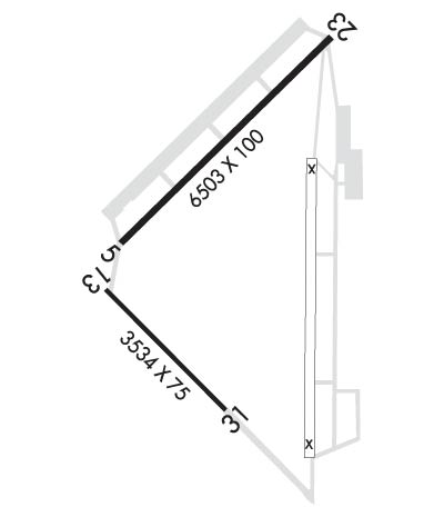
| Lat: N 3447.5 Long: W 07922.0 Elev: 216 Var: +08 Longest Runway: 6503 | ||
| Clr Del: 135.07 GCO AWOS: 134.12 CTAF: 122.8 | ||
| |||||||||||||||||||||||
| |||||||||||||||||||||||
| |||||||||||||||||||||||
| Rwy | Rwy | |||||||
| 6503x100 | 6503' | 110.70 - 053° | 6503x100 | 6316' | ||||
| 3536x75 | 3536' | 3536x75 | 3536' | |||||
| Runway ID | Single Wheel | Double Wheel | Double Tandem Wheel | Dual Double Wheel |
| 05/23 | 60,000 | 160,000 | 256,000 | N/A |
| 13/31 | 25,000 | 35,000 | N/A | N/A |
| These numbers are Advisory and are not limits. The Airport Manager should have more accurate Weight Limits | ||||
 Airport Diagram might not be current. | |
| Facility Name: | LAURINBURG-MAXTON |
| City Name: | MAXTON |
| County: | SCOTLAND |
| State abbrev: | NC |
| State Name: | NORTH CAROLINA |
| Ownership: | PUBLICLY OWNED |
| Use: | OPEN TO THE PUBLIC |
| Owner's Name: | TOWN OF LAURINBURG & MAXTON |
| Address: | 16701 AIRPORT RD |
| MAXTON, NC 28364 | |
| Owner's Phone: | (910) 844-3601 |
| Manager's Name: | RANDY HOFFMAN; JO ANN GENTRY EXEC DIR AIRPORT COMMISSION. |
| Address: | 16701 AIRPORT RD |
| MAXTON, NC 28364 | |
| Phone: | (910) 844-3601 |
| FAA Region: | SOUTHERN |
| FAA Field Office: | MEM |
| Date | Sunrise | Sunset |
|---|---|---|
| 09/24/21 Friday | 7:07 | 19:12 |
| 09/25/21 Saturday | 7:07 | 19:10 |
| 09/26/21 Sunday | 7:08 | 19:09 |
| 09/27/21 Monday | 7:09 | 19:07 |
| 09/28/21 Tuesday | 7:10 | 19:06 |
| 09/29/21 Wednesday | 7:10 | 19:05 |
| 09/30/21 Thursday | 7:11 | 19:03 |
| 10/01/21 Friday | 7:12 | 19:02 |
| 10/02/21 Saturday | 7:13 | 19:00 |
| 10/03/21 Sunday | 7:13 | 18:59 |
| 10/04/21 Monday | 7:14 | 18:58 |
| 10/05/21 Tuesday | 7:15 | 18:56 |
| 10/06/21 Wednesday | 7:16 | 18:55 |
| 10/07/21 Thursday | 7:17 | 18:54 |
| Airport Attendance Schedule | MON-FRI 0800-1700; FOR SERVICE AFTER HRS CALL 910-277-0367 OR 910-318-6907. |
| Airport Status | OPERATIONAL (This Status can change at any time - please check NOTAMS) |
| Airport Lighting Schedule | ACTVT MALSR RWY 05, PAPI RWY 05/23, HIRL RWY 05/23 - CTAF. |
| Airport Storage Available | Tie Downs, Hanger |
| Extra Services Available | Flight Instruction, Parachute Jumping, Aircraft Sales |
| Wind Indicator | YES - (lighted) |
| Control Tower | NO |
| CTAF Frequency | 122.800 |
| Unicom Frequency | 122.800 |
| Rotating Beacon Color | CLEAR-GREEN (Light Land Airport) |
| Segmented Circle | YES |
| Landing Fee | YES |
| Airport Inspected | STATE - performed by STATE AERONAUTICAL PERSONNEL |
| Inspection Date | 07/04/2019 |
| Type of Fuel Available | Grade 100LL, JET A-1 (icing inhibitor, freeze point -50C); -1024 HR SELF SERVICE WITH CREDIT CARD. |
| Airframe Repair Service | MINOR; CALL AIRPORT TO ARRANGE FOR SERVICE |
| Power Plant Repair Service | MINOR |
| Latitude | N3447.5 |
| Longitude | W07922.0 (ESTIMATED) |
| Arpt Elevation | 215ft (SURVEYED) |
| Magnetic Variation | 08W |
| 3 miles N | of MAXTON |
| Traffic Pattern Altitude | |
| Sectional Chart | CHARLOTTE |
| Operations (Reported) | Yearly | Avg. Daily |
|---|---|---|
| General Aviation Transient | 10000 | 27 |
| General Aviation Local | 10000 | 27 |
| Air Taxi | 4000 | 11 |
| Commerical | 0 | 0 |
| Commuter | 0 | 0 |
| Military | 30000 | 82 |
| Aircraft based on Field | |
|---|---|
| General Aviation Singles | 13 |
| General Aviation Multi | 3 |
| Jet Aircraft | 0 |
| General Aviation Helicopters | 0 |
| Military Aircraft | 0 |
| Gliders | 0 |
| Ultralights | 0 |
| FSS on field | NO |
| FSS tie-in | RALEIGH |
| FSS Phone | 1-800-WX-BRIEF |
| Who issues Notams | MEB |
| Notam D service at airport | YES |
| ARTCC Name | WASHINGTON |
| Airport Certification | |
| Aircraft Rescue & Firefighting Index | None |
| Airport of Entry | No |
| Custom Landing Rights | No |
| Joint Civil/Military | No |
| Military Landing rights | YES |
| NATIONAL PLAN OF INTEGRATED AIRPORT SYSTEMS (NPIAS) |
| GRANT AGREEMENTS UNDER FAAP/ADAP/AIP |
| SURPLUS PROPERTY AGREEMENT UNDER PUBLIC LAW 289 |
| SURPLUS PROPERTY AGREEMENT UNDER REGULATION 16-WAA |
| ASSURANCES PURSUANT TO TITLE VI, CIVIL RIGHTS ACT OF 1964 |
| MIL ACFT FQTLY OPER FM CLSD PTN OF RWY 13/31 & CLSD RWY 18/36. |
| HVY PAJA AT SOUTH END OF CLSD RWY 18/36 & SOUTH SIDE RWY 13/31. |
| GCO AVBL ON FREQ 135.075 THRU FAY CD. |
| FARMING EQPT AND MIL OPS ON & INVOF ARPT. |
| RWY 13/31 DALGT USE ONLY. |
| NO LN OF SIGHT BTN RWY ENDS. |
| FOR CD IF UNA VIA GCO CTC FAYETTEVILLE APCH AT 910-484-8012. |
| RWY 13/3 1 2750 FT CONC STOPWAY ON SE END. |
Airport Communications & Frequencies:
| ||||||||||||||
| Runway: 05 | Runway: 23 | ||
| Mag heading: | 54° | Mag heading: | 234° |
| Rwy Slope: | -.24% Down | Rwy Slope: | .24% Up |
| Approach: | ILS | Approach: | |
| Pattern: | Left Traffic | Pattern: | Right Traffic |
| Markings: | PRECISION INSTRUMENT | Markings: | PRECISION INSTRUMENT |
| Marking Condition: | GOOD | Marking Condition: | GOOD |
| Arresting Dev: | Arresting Dev: | ||
| Lat & Long: | N3447.4 W07922.3 | Lat. & Long.: | N3448.2 W07921.4 |
| Elev: | 215.6 ft. MSL | Elev: | 200.0 ft. MSL |
| TCH: | 52 ft. AGL | TCH: | 38 ft. AGL |
| Visual Glide Path: | 3.00 degrees | Visual Glide Path: | 3.00 degrees |
| Displaced Threshold: | No | Displaced Threshold: | 187 feet |
| Touchdown Zone: | YES | Touchdown Zone: | YES |
| Touchdown Elev.: | 215.6 feet | Touchdown Elev.: | 214.3 feet |
| Visual Glide Slope: | 4-Light PAPI on LEFT side of Runway | Visual Glide Slope: | 4-Light PAPI on LEFT side of Runway; PAPI OTS INDEF. |
| RVR Equipment: | RVR Equipment: | ||
| RVV Equipment: | NO | RVV Equipment: | NO |
| Approach Lights: | MALSR - 1,400 foot medium intensity approach lighting system with runway alignment indicator lights | Approach Lights: | |
| REIL: | NO | REIL: | NO |
| Centerline Lights: | NO | Centerline Lights: | NO |
| Touchdown lights: | NO | Touchdown lights: | NO |
| Runway Category: | Precision Instrument Runway | Runway Category: | Runway with a Non-precision Approach having visibility minimums greater than 3/4 mile |
| Declared Distances: | Declared Distances: | ||
| Obstructions: | Obstructions: | ROAD | |
| Marked: | Marked: | NOT Marked/Lighted | |
| Clearance slope: | 50:1; APPROACH SLOPE 35:1 AT MARKED DSPLCD THLD | Clearance slope: | 20:1 |
| Obstruction height: | Obstruction height: | 20 feet AGL | |
| Dist. from runway: | Dist. from runway: | 617 feet | |
| Centerline offset: | Centerline offset: | ||
| Comments: | Comments: |
| Runway: 13 | Runway: 31 | ||
| Mag heading: | 143° | Mag heading: | 323° |
| Rwy Slope: | -.24% Down | Rwy Slope: | .24% Up |
| Approach: | Approach: | ||
| Pattern: | Right Traffic | Pattern: | Left Traffic |
| Markings: | BASIC | Markings: | BASIC |
| Marking Condition: | GOOD | Marking Condition: | GOOD |
| Arresting Dev: | Arresting Dev: | ||
| Lat & Long: | N3447.2 W07922.4 | Lat. & Long.: | N3446.8 W07921.9 |
| Elev: | 215.5 ft. MSL | Elev: | 207.0 ft. MSL |
| TCH: | TCH: | ||
| Visual Glide Path: | Visual Glide Path: | ||
| Displaced Threshold: | No | Displaced Threshold: | No |
| Touchdown Zone: | YES | Touchdown Zone: | YES |
| Touchdown Elev.: | 215.5 feet | Touchdown Elev.: | 215.2 feet |
| Visual Glide Slope: | Visual Glide Slope: | ||
| RVR Equipment: | RVR Equipment: | ||
| RVV Equipment: | NO | RVV Equipment: | NO |
| Approach Lights: | Approach Lights: | ||
| REIL: | NO | REIL: | NO |
| Centerline Lights: | NO | Centerline Lights: | NO |
| Touchdown lights: | NO | Touchdown lights: | NO |
| Runway Category: | Runway with a Visual Approach | Runway Category: | Runway with a Visual Approach |
| Declared Distances: | Declared Distances: | ||
| Obstructions: | TREES | Obstructions: | ACFT |
| Marked: | NOT Marked/Lighted | Marked: | NOT Marked/Lighted |
| Clearance slope: | 22:1 | Clearance slope: | 13:1 |
| Obstruction height: | 67 feet AGL | Obstruction height: | 59 feet AGL |
| Dist. from runway: | 1685 feet | Dist. from runway: | 976 feet |
| Centerline offset: | 219 left of centerline | Centerline offset: | 241 feet left of centerline |
| Comments: | Comments: |
Thanks for using FltPlan.com
all rights reserved © 1999-2021 by Flight Plan LLC


