
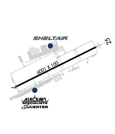
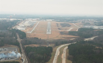
| GWINNETT COUNTY - BRISCOE FLD LAWRENCEVILLE GA |
| |
| Lat: N 3358.7 Long: W 08357.7 Elev: 1062 Var: +05 Longest Runway: 6001 | ||
| Clr Del: 121.8/134.0 Dept. ATIS: 132.27 Arr. ATIS: 132.27 AWOS: 132.27 Ground: 121.8 Tower: 124.1 | ||
| |||||||||||||||||||||||||||||||||||||||||||||||||||||||||||||||||||||
| |||||||||||||||||||||||||||||||||||||||||||||||||||||||||||||||||||||
| |||||||||||||||||||||||||||||||||||||||||||||||||||||||||||||||||||||
| |||||||||||||||||||||||||||||||||||||||||||||||||||||||||||||||||||||
| Rwy | Rwy | |||||||
| 6001x100 | 6001' | 6001x100 | 6001' | 109.95 - 248° | ||||
| Runway ID | Single Wheel | Double Wheel | Double Tandem Wheel | Dual Double Wheel |
| 07/25 | 93,000 | 120,000 | N/A | N/A |
| These numbers are Advisory and are not limits. The Airport Manager should have more accurate Weight Limits | ||||
 Airport Diagram might not be current. | |
| Facility Name: | GWINNETT COUNTY/BRISCOE FLD |
| City Name: | LAWRENCEVILLE |
| County: | GWINNETT |
| State abbrev: | GA |
| State Name: | GEORGIA |
| Ownership: | PUBLICLY OWNED |
| Use: | OPEN TO THE PUBLIC |
| Owner's Name: | GWINNETT COUNTY |
| Address: | 75 LANGELY DR |
| LAWRENCEVILLE, GA 30046 | |
| Owner's Phone: | 770-822-7000 |
| Manager's Name: | MATTHEW SMITH |
| Address: | 600 BRISCOE BLVD |
| LAWRENCEVILLE, GA 30046 | |
| Phone: | 770-822-5196 |
| FAA Region: | SOUTHERN |
| FAA Field Office: | ATL |
| Date | Sunrise | Sunset |
|---|---|---|
| 06/09/26 Tuesday | 6:24 | 20:46 |
| 06/10/26 Wednesday | 6:24 | 20:47 |
| 06/11/26 Thursday | 6:24 | 20:47 |
| 06/12/26 Friday | 6:24 | 20:47 |
| 06/13/26 Saturday | 6:24 | 20:48 |
| 06/14/26 Sunday | 6:24 | 20:48 |
| 06/15/26 Monday | 6:24 | 20:49 |
| 06/16/26 Tuesday | 6:24 | 20:49 |
| 06/17/26 Wednesday | 6:24 | 20:49 |
| 06/18/26 Thursday | 6:24 | 20:49 |
| 06/19/26 Friday | 6:25 | 20:50 |
| 06/20/26 Saturday | 6:25 | 20:50 |
| 06/21/26 Sunday | 6:25 | 20:50 |
| 06/22/26 Monday | 6:25 | 20:50 |
| Airport Attendance Schedule | CONTINUOUS |
| Airport Status | OPERATIONAL (This Status can change at any time - please check NOTAMS) |
| Airport Lighting Schedule | WHEN ATCT CLSD ACTVT MALSR RWY 25; HIRL RWY 07/25 - CTAF. PAPI RWY 07 & 25 OPR CONSLY. |
| Airport Storage Available | Tie Downs |
| Extra Services Available | Air Freight, Air Ambulance, Charter, Flight Instruction, Aircraft Rental, Aircraft Sales, Annual Surveying, Glider Towing |
| Wind Indicator | YES - (lighted) |
| Control Tower | YES |
| CTAF Frequency | 124.100 |
| Unicom Frequency | 123.050 |
| Rotating Beacon Color | WG |
| Segmented Circle | YES |
| Landing Fee | NO |
| Airport Inspected | STATE - performed by STATE AERONAUTICAL PERSONNEL |
| Inspection Date | 05/02/2025 |
| Type of Fuel Available | Grade 100LL, JET A |
| Airframe Repair Service | MAJOR |
| Power Plant Repair Service | MAJOR |
| Latitude | N3358.7 |
| Longitude | W08357.7 (ESTIMATED) |
| Arpt Elevation | 1061ft (SURVEYED) |
| Magnetic Variation | 05W |
| 2 miles NE | of LAWRENCEVILLE |
| Traffic Pattern Altitude | 1039; TPA FOR LIGHT ACFT 1039 FT; TPA FOR JET & TURBO PROP ACFT 1539 FT. |
| Sectional Chart | ATLANTA |
| Operations (Reported) | Yearly | Avg. Daily |
|---|---|---|
| General Aviation Transient | 0 | 0 |
| General Aviation Local | 0 | 0 |
| Air Taxi | 0 | 0 |
| Commerical | 0 | 0 |
| Commuter | 0 | 0 |
| Military | 0 | 0 |
| Aircraft based on Field | |
|---|---|
| General Aviation Singles | 0 |
| General Aviation Multi | 0 |
| Jet Aircraft | 0 |
| General Aviation Helicopters | 0 |
| Military Aircraft | 0 |
| Gliders | 0 |
| Ultralights | 0 |
| FSS on field | NO |
| FSS tie-in | MACON |
| FSS Phone | 1-800-WX-BRIEF |
| Who issues Notams | LZU |
| Notam D service at airport | YES |
| ARTCC Name | ATLANTA |
| Airport Certification | |
| Aircraft Rescue & Firefighting Index | None |
| Airport of Entry | No |
| Custom Landing Rights | No |
| Joint Civil/Military | No |
| Military Landing rights | YES |
| NATIONAL PLAN OF INTEGRATED AIRPORT SYSTEMS (NPIAS) |
| GRANT AGREEMENTS UNDER FAAP/ADAP/AIP |
| ASSURANCES PURSUANT TO TITLE VI, CIVIL RIGHTS ACT OF 1964 |
| TWY T HAS NSTD MARKING. |
| RWY 07/2 5 PCR VALUE: 330/F/C/X/T |
Airport Communications & Frequencies:
| ||||||||||||||||||||||||
| Runway: 07 | Runway: 25 | ||
| Mag heading: | 69° | Mag heading: | 249° |
| Rwy Slope: | -.50% Down | Rwy Slope: | .50% Up |
| Approach: | Approach: | ILS | |
| Pattern: | Left Traffic | Pattern: | Left Traffic |
| Markings: | PRECISION INSTRUMENT | Markings: | PRECISION INSTRUMENT |
| Marking Condition: | GOOD | Marking Condition: | GOOD |
| Arresting Dev: | Arresting Dev: | ||
| Lat & Long: | N3358.5 W08358.3 | Lat. & Long.: | N3358.9 W08357.2 |
| Elev: | 1061.5 ft. MSL | Elev: | 1031.3 ft. MSL |
| TCH: | 41 ft. AGL | TCH: | 48 ft. AGL |
| Visual Glide Path: | 3.00 degrees | Visual Glide Path: | 3.00 degrees |
| Displaced Threshold: | No | Displaced Threshold: | No |
| Touchdown Zone: | YES | Touchdown Zone: | YES |
| Touchdown Elev.: | 1061.5 feet | Touchdown Elev.: | 1038.7 feet |
| Visual Glide Slope: | 2-Light PAPI on LEFT side of Runway | Visual Glide Slope: | 2-Light PAPI on LEFT side of Runway |
| RVR Equipment: | RVR Equipment: | ||
| RVV Equipment: | NO | RVV Equipment: | NO |
| Approach Lights: | Approach Lights: | MALSR - 1,400 foot medium intensity approach lighting system with runway alignment indicator lights | |
| REIL: | NO | REIL: | NO |
| Centerline Lights: | NO | Centerline Lights: | NO |
| Touchdown lights: | NO | Touchdown lights: | NO |
| Runway Category: | Runway with a Non-precision Approach having visibility minimums greater than 3/4 mile | Runway Category: | Precision Instrument Runway |
| Declared Distances: | Declared Distances: | ||
| Obstructions: | POLE | Obstructions: | TREES |
| Marked: | NOT Marked/Lighted | Marked: | NOT Marked/Lighted |
| Clearance slope: | 20:1 | Clearance slope: | 10:1 |
| Obstruction height: | 48 feet AGL | Obstruction height: | 10 feet AGL |
| Dist. from runway: | 1160 feet | Dist. from runway: | 301 feet |
| Centerline offset: | 511 right of centerline | Centerline offset: | 505 feet left of centerline |
| Comments: | Comments: |
Thanks for using FltPlan.com
all rights reserved © 1999-2026 by Flight Plan LLC