
| SOUTH HAVEN AREA RGNL SOUTH HAVEN MI |
| |
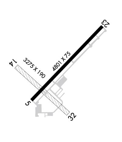
| Lat: N 4221.1 Long: W 08615.3 Elev: 666 Var: +03 Longest Runway: 4801 | ||
| AWOS: 118.02 CTAF: 122.8 | ||
| ||||||||||||||||||||||||||||||||||||||||||||
| ||||||||||||||||||||||||||||||||||||||||||||
| ||||||||||||||||||||||||||||||||||||||||||||
| Rwy | Rwy | |||||||
| 4801x75 | 4801' | 4801x75 | 4801' | |||||
| 3275x190 | 2310' | 3275x190 | 2033' | |||||
| Runway ID | Single Wheel | Double Wheel | Double Tandem Wheel | Dual Double Wheel |
| 05/23 | 12,000 | N/A | N/A | N/A |
| 14/32 | N/A | N/A | N/A | N/A |
| These numbers are Advisory and are not limits. The Airport Manager should have more accurate Weight Limits | ||||
 Airport Diagram might not be current. | |
| Facility Name: | SOUTH HAVEN AREA RGNL |
| City Name: | SOUTH HAVEN |
| County: | VAN BUREN |
| State abbrev: | MI |
| State Name: | MICHIGAN |
| Ownership: | PUBLICLY OWNED |
| Use: | OPEN TO THE PUBLIC |
| Owner's Name: | SO HAVEN AREA RGNL ARPT AUTH |
| Address: | 73020 COUNTY ROAD 380 |
| SOUTH HAVEN, MI 49090-9441 | |
| Owner's Phone: | 269-637-7343 |
| Manager's Name: | JOHN CARLSON |
| Address: | 73020 COUNTY ROAD 380 |
| SOUTH HAVEN, MI 49090-9441 | |
| Phone: | 269-637-7343; CELL 269-906-2233. |
| FAA Region: | GREAT LAKES |
| FAA Field Office: | DET |
| Date | Sunrise | Sunset |
|---|---|---|
| 09/24/21 Friday | 7:34 | 19:39 |
| 09/25/21 Saturday | 7:35 | 19:37 |
| 09/26/21 Sunday | 7:36 | 19:36 |
| 09/27/21 Monday | 7:37 | 19:34 |
| 09/28/21 Tuesday | 7:39 | 19:32 |
| 09/29/21 Wednesday | 7:40 | 19:30 |
| 09/30/21 Thursday | 7:41 | 19:29 |
| 10/01/21 Friday | 7:42 | 19:27 |
| 10/02/21 Saturday | 7:43 | 19:25 |
| 10/03/21 Sunday | 7:44 | 19:23 |
| 10/04/21 Monday | 7:45 | 19:22 |
| 10/05/21 Tuesday | 7:46 | 19:20 |
| 10/06/21 Wednesday | 7:47 | 19:18 |
| 10/07/21 Thursday | 7:48 | 19:17 |
| Airport Attendance Schedule | 7 Days A Week 0900-1700 |
| Airport Status | OPERATIONAL (This Status can change at any time - please check NOTAMS) |
| Airport Lighting Schedule | ACTVT OR INCR INTST REIL RWY 05 & 23; MIRL RWY 05/23 - CTAF. PAPI RWY 05 & 23 OPR CONSLY; MIRL RWY 05/23 PRESET LOW INTST DUSK-2300. |
| Airport Storage Available | Tie Downs |
| Extra Services Available | NONE |
| Wind Indicator | YES - (lighted) |
| Control Tower | NO |
| CTAF Frequency | 122.800 |
| Unicom Frequency | 122.800 |
| Rotating Beacon Color | CLEAR-GREEN (Light Land Airport) |
| Segmented Circle | YES |
| Landing Fee | NO |
| Airport Inspected | STATE - performed by STATE AERONAUTICAL PERSONNEL |
| Inspection Date | 01/06/2021 |
| Type of Fuel Available | Grade 100LL, JET A |
| Airframe Repair Service | MAJOR |
| Power Plant Repair Service | MAJOR |
| Latitude | N4221.1 |
| Longitude | W08615.3 (ESTIMATED) |
| Arpt Elevation | 665ft (SURVEYED) |
| Magnetic Variation | 03W |
| 3 miles S | of SOUTH HAVEN |
| Traffic Pattern Altitude | |
| Sectional Chart | CHICAGO |
| Operations (Reported) | Yearly | Avg. Daily |
|---|---|---|
| General Aviation Transient | 13508 | 37 |
| General Aviation Local | 13508 | 37 |
| Air Taxi | 0 | 0 |
| Commerical | 0 | 0 |
| Commuter | 0 | 0 |
| Military | 0 | 0 |
| Aircraft based on Field | |
|---|---|
| General Aviation Singles | 40 |
| General Aviation Multi | 3 |
| Jet Aircraft | 0 |
| General Aviation Helicopters | 0 |
| Military Aircraft | 0 |
| Gliders | 0 |
| Ultralights | 0 |
| FSS on field | NO |
| FSS tie-in | LANSING |
| FSS Phone | 1-800-WX-BRIEF |
| Who issues Notams | LWA |
| Notam D service at airport | YES |
| ARTCC Name | CHICAGO |
| Airport Certification | |
| Aircraft Rescue & Firefighting Index | None |
| Airport of Entry | No |
| Custom Landing Rights | No |
| Joint Civil/Military | No |
| Military Landing rights | No |
| NATIONAL PLAN OF INTEGRATED AIRPORT SYSTEMS (NPIAS) |
| GRANT AGREEMENTS UNDER FAAP/ADAP/AIP |
| ASSURANCES PURSUANT TO TITLE VI, CIVIL RIGHTS ACT OF 1964 |
| THIS AIRPORT HAS BEEN SURVEYED BY THE NATIONAL GEODETIC SURVEY. |
| DEER & LRG BIRDS ON & INVOF ARPT. |
| AG OPS SUMMER MONTHS. |
| ADMIN BLDG ACES, PRESS V, THEN III & II SIMUL, THEN I. |
| FOR FLD CONDS AFT HRS CALL AMGR CELL. |
| CK LCL CONDS BFR USE OF TURF RWY 14/32 - CALL AMGR. |
| FOR CD CTC CHICAGO ARTCC AT 630-906-8921. |
Airport Communications & Frequencies:
| |||||||||||||||||
| Runway: 05 | Runway: 23 | ||
| Mag heading: | 47° | Mag heading: | 227° |
| Rwy Slope: | .28% Up | Rwy Slope: | -.28% Down |
| Approach: | Approach: | ||
| Pattern: | Left Traffic | Pattern: | Left Traffic |
| Markings: | NONPRECISION INSTRUMENT | Markings: | NONPRECISION INSTRUMENT |
| Marking Condition: | GOOD | Marking Condition: | GOOD |
| Arresting Dev: | Arresting Dev: | ||
| Lat & Long: | N4220.9 W08615.6 | Lat. & Long.: | N4221.4 W08614.9 |
| Elev: | 652.0 ft. MSL | Elev: | 665.6 ft. MSL |
| TCH: | 33 ft. AGL | TCH: | 33 ft. AGL |
| Visual Glide Path: | 3.50 degrees | Visual Glide Path: | 3.50 degrees |
| Displaced Threshold: | No | Displaced Threshold: | No |
| Touchdown Zone: | YES | Touchdown Zone: | YES |
| Touchdown Elev.: | 659.1 feet | Touchdown Elev.: | 665.6 feet |
| Visual Glide Slope: | 4-Light PAPI on LEFT side of Runway | Visual Glide Slope: | 4-Light PAPI on LEFT side of Runway |
| RVR Equipment: | RVR Equipment: | ||
| RVV Equipment: | NO | RVV Equipment: | NO |
| Approach Lights: | Approach Lights: | ||
| REIL: | YES | REIL: | YES |
| Centerline Lights: | NO | Centerline Lights: | NO |
| Touchdown lights: | NO | Touchdown lights: | NO |
| Runway Category: | Runway with a Non-precision Approach | Runway Category: | Runway with a Non-precision Approach |
| Declared Distances: | Declared Distances: | ||
| Obstructions: | TREES | Obstructions: | TREES |
| Marked: | NOT Marked/Lighted | Marked: | NOT Marked/Lighted |
| Clearance slope: | 16:1 | Clearance slope: | 15:1 |
| Obstruction height: | 74 feet AGL | Obstruction height: | 57 feet AGL |
| Dist. from runway: | 1445 feet | Dist. from runway: | 1060 feet |
| Centerline offset: | 300 right of centerline | Centerline offset: | 195 feet right of centerline |
| Comments: | Comments: |
| Runway: 14 | Runway: 32 | ||
| Mag heading: | 136° | Mag heading: | 316° |
| Rwy Slope: | -.31% Down | Rwy Slope: | .31% Up |
| Approach: | Approach: | ||
| Pattern: | Left Traffic | Pattern: | Left Traffic |
| Markings: | Markings: | ||
| Marking Condition: | DTHR MKD WITH 3 FT YELLOW CONES, 3 EACH SIDE. | Marking Condition: | DTHR MKD WITH 3 FT YELLOW CONES, 3 EACH SIDE. |
| Arresting Dev: | Arresting Dev: | ||
| Lat & Long: | N4221.2 W08615.8 | Lat. & Long.: | N4220.8 W08615.2 |
| Elev: | 658.0 ft. MSL | Elev: | 648.0 ft. MSL |
| TCH: | TCH: | ||
| Visual Glide Path: | Visual Glide Path: | ||
| Displaced Threshold: | 965 feet | Displaced Threshold: | 1242 feet |
| Touchdown Zone: | YES | Touchdown Zone: | YES |
| Touchdown Elev.: | 661.0 feet | Touchdown Elev.: | 657.0 feet |
| Visual Glide Slope: | Visual Glide Slope: | ||
| RVR Equipment: | RVR Equipment: | ||
| RVV Equipment: | NO | RVV Equipment: | NO |
| Approach Lights: | Approach Lights: | ||
| REIL: | NO | REIL: | NO |
| Centerline Lights: | NO | Centerline Lights: | NO |
| Touchdown lights: | NO | Touchdown lights: | NO |
| Runway Category: | Runway with a Visual Approach | Runway Category: | Runway with a Visual Approach |
| Declared Distances: | Declared Distances: | ||
| Obstructions: | TREES | Obstructions: | TREE |
| Marked: | NOT Marked/Lighted | Marked: | NOT Marked/Lighted |
| Clearance slope: | APCH RATIO 7:1 TO DTHR OVR 42 FT TREES, 326 FT DIST, 157 FT L; 14:1 BASED ON STRAIGHT OUT OVR 77 FT TREES, 1081 FT DIST, 95 FT L/R. | Clearance slope: | 5:1; APCH RATIO 20:1 TO DTHR. |
| Obstruction height: | 64 feet AGL | Obstruction height: | 46 feet AGL |
| Dist. from runway: | 0 feet | Dist. from runway: | 235 feet |
| Centerline offset: | 103 left of centerline | Centerline offset: | 148 feet left of centerline |
| Comments: | Comments: |
Thanks for using FltPlan.com
all rights reserved © 1999-2021 by Flight Plan LLC
