
| SOUTHWEST WASHINGTON RGNL KELSO WA |
| |
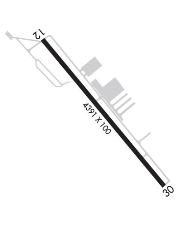
| Lat: N 4607.1 Long: W 12253.9 Elev: 20 Var: -17 Longest Runway: 4391 | ||
| AWOS: 135.07 CTAF: 122.8 | ||
| ||||||
| ||||||
|
| Rwy | Rwy | |||||||
| 4391x100 | 4391' | 4391x100 | 4391' | |||||
| Runway ID | Single Wheel | Double Wheel | Double Tandem Wheel | Dual Double Wheel |
| 12/30 | 38,000 | 46,000 | 74,000 | N/A |
| These numbers are Advisory and are not limits. The Airport Manager should have more accurate Weight Limits | ||||
 Airport Diagram might not be current. | |
| Facility Name: | SOUTHWEST WASHINGTON RGNL |
| City Name: | KELSO |
| County: | COWLITZ |
| State abbrev: | WA |
| State Name: | WASHINGTON |
| Ownership: | PUBLICLY OWNED |
| Use: | OPEN TO THE PUBLIC |
| Owner's Name: | CITY OF KELSO |
| Address: | 203 S. PACIFIC AVE , PO BOX 819 |
| KELSO, WA 98626 | |
| Owner's Phone: | (360) 577-3370 |
| Manager's Name: | CHRISTOPHER PAOLINI |
| Address: | 2222 SOUTH PACIFIC AVENUE; ARPT OFC ADS (NOT FOR MAILING): 2215 B PARROTT WAY, KELSO, WA 98626 |
| KELSO, WA 98626 | |
| Phone: | (360) 261-8268 |
| FAA Region: | NORTHWEST MOUNTAIN |
| FAA Field Office: | SEA |
| Date | Sunrise | Sunset |
|---|---|---|
| 09/24/21 Friday | 7:01 | 19:06 |
| 09/25/21 Saturday | 7:02 | 19:04 |
| 09/26/21 Sunday | 7:03 | 19:02 |
| 09/27/21 Monday | 7:05 | 19:00 |
| 09/28/21 Tuesday | 7:06 | 18:58 |
| 09/29/21 Wednesday | 7:07 | 18:56 |
| 09/30/21 Thursday | 7:09 | 18:54 |
| 10/01/21 Friday | 7:10 | 18:52 |
| 10/02/21 Saturday | 7:11 | 18:50 |
| 10/03/21 Sunday | 7:12 | 18:48 |
| 10/04/21 Monday | 7:14 | 18:46 |
| 10/05/21 Tuesday | 7:15 | 18:44 |
| 10/06/21 Wednesday | 7:16 | 18:42 |
| 10/07/21 Thursday | 7:18 | 18:40 |
| Airport Attendance Schedule | 7 Days A Week 0800-1700 |
| Airport Status | OPERATIONAL (This Status can change at any time - please check NOTAMS) |
| Airport Lighting Schedule | ACTVT REIL RWY 12 & 30; PAPI RWY 12; MIRL RWY 12/30 - CTAF. |
| Airport Storage Available | Tie Downs |
| Extra Services Available | Crop Dusting, Avionics, Charter, Flight Instruction, Aircraft Rental, Aircraft Sales |
| Wind Indicator | YES - (lighted) |
| Control Tower | NO |
| CTAF Frequency | 122.800 |
| Unicom Frequency | 122.800 |
| Rotating Beacon Color | CLEAR-GREEN (Light Land Airport) |
| Segmented Circle | YES |
| Landing Fee | NO |
| Airport Inspected | STATE - performed by STATE AERONAUTICAL PERSONNEL |
| Inspection Date | 05/06/2021 |
| Type of Fuel Available | Grade 100LL, JET A (freeze point -40C); -1024 HR SELF SVC CREDIT CARD FUEL FAC 100LL. AFT HRS JET-A SVC CALL-OUT AVBL. |
| Airframe Repair Service | MAJOR |
| Power Plant Repair Service | MAJOR |
| Latitude | N4607.1 |
| Longitude | W12253.9 (ESTIMATED) |
| Arpt Elevation | 20ft (SURVEYED) |
| Magnetic Variation | 17E |
| 2 miles SE | of KELSO |
| Traffic Pattern Altitude | |
| Sectional Chart | SEATTLE |
| Operations (Reported) | Yearly | Avg. Daily |
|---|---|---|
| General Aviation Transient | 18800 | 52 |
| General Aviation Local | 19700 | 54 |
| Air Taxi | 1675 | 5 |
| Commerical | 0 | 0 |
| Commuter | 0 | 0 |
| Military | 685 | 2 |
| Aircraft based on Field | |
|---|---|
| General Aviation Singles | 53 |
| General Aviation Multi | 5 |
| Jet Aircraft | 1 |
| General Aviation Helicopters | 1 |
| Military Aircraft | 0 |
| Gliders | 0 |
| Ultralights | 0 |
| FSS on field | NO |
| FSS tie-in | SEATTLE |
| FSS Phone | 1-800-WX-BRIEF |
| Who issues Notams | KLS |
| Notam D service at airport | YES |
| ARTCC Name | SEATTLE |
| Airport Certification | |
| Aircraft Rescue & Firefighting Index | None |
| Airport of Entry | No |
| Custom Landing Rights | YES; FLIGHT NOTIFICATION SERVICE (ADCUS) AVBL. |
| Joint Civil/Military | No |
| Military Landing rights | YES |
| NATIONAL PLAN OF INTEGRATED AIRPORT SYSTEMS (NPIAS) |
| GRANT AGREEMENTS UNDER FAAP/ADAP/AIP |
| ASSURANCES PURSUANT TO TITLE VI, CIVIL RIGHTS ACT OF 1964 |
| NMRS FLOCKS OF BIRDS ON & INVOF ARPT. |
| NO FLD COND NOTAMS AVBL M-F 1700-0800 AND ALL DAY SAT AND SUN. |
| FOR CD IF UNA TO CTC ON FSS FREQ, CTC SEATTLE ARTCC AT 253-351-3694. |
| RWY 12/3 0 RY 12/30 MIRL NSTD SPACING. |
Airport Communications & Frequencies:
| |||||||||
| Runway: 12 | Runway: 30 | ||
| Mag heading: | 123° | Mag heading: | 303° |
| Rwy Slope: | -.09% Down | Rwy Slope: | .09% Up |
| Approach: | Approach: | ||
| Pattern: | Right Traffic | Pattern: | Left Traffic |
| Markings: | NONPRECISION INSTRUMENT | Markings: | NONPRECISION INSTRUMENT |
| Marking Condition: | GOOD | Marking Condition: | GOOD |
| Arresting Dev: | Arresting Dev: | ||
| Lat & Long: | N4607.4 W12254.2 | Lat. & Long.: | N4606.8 W12253.6 |
| Elev: | 20.0 ft. MSL | Elev: | 15.9 ft. MSL |
| TCH: | 65 ft. AGL | TCH: | 62 ft. AGL |
| Visual Glide Path: | 4.00 degrees | Visual Glide Path: | 4.00 degrees |
| Displaced Threshold: | No | Displaced Threshold: | No |
| Touchdown Zone: | YES | Touchdown Zone: | YES |
| Touchdown Elev.: | 20.1 feet | Touchdown Elev.: | 17.2 feet |
| Visual Glide Slope: | 4-Light PAPI on RIGHT side of Runway | Visual Glide Slope: | 4-Light PAPI on LEFT side of Runway |
| RVR Equipment: | RVR Equipment: | ||
| RVV Equipment: | NO | RVV Equipment: | NO |
| Approach Lights: | Approach Lights: | ||
| REIL: | YES | REIL: | YES |
| Centerline Lights: | NO | Centerline Lights: | NO |
| Touchdown lights: | NO | Touchdown lights: | NO |
| Runway Category: | Runway with a Non-precision Approach | Runway Category: | Runway with a Visual Approach |
| Declared Distances: | Declared Distances: | ||
| Obstructions: | TREES | Obstructions: | TREES |
| Marked: | NOT Marked/Lighted | Marked: | NOT Marked/Lighted |
| Clearance slope: | 24:1 | Clearance slope: | 22:1 |
| Obstruction height: | 45 feet AGL | Obstruction height: | 31 feet AGL |
| Dist. from runway: | 1300 feet | Dist. from runway: | 900 feet |
| Centerline offset: | 110 left of centerline | Centerline offset: | |
| Comments: | Comments: | +3' HILL FROM 40' TO 200'; 105L. |
Thanks for using FltPlan.com
all rights reserved © 1999-2021 by Flight Plan LLC
