
| DERBY FIELD LOVELOCK NV |
| |
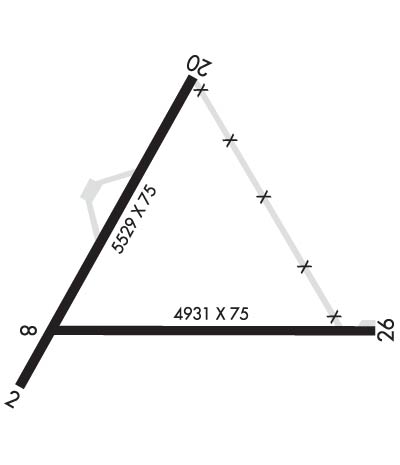
| Lat: N 4004.0 Long: W 11833.9 Elev: 3908 Var: -14 Longest Runway: 5529 | ||
| AWOS: 120.67 CTAF: 122.8 | ||
| ||||||||||||||||||||||||||||||||||||||||||||
| ||||||||||||||||||||||||||||||||||||||||||||
| ||||||||||||||||||||||||||||||||||||||||||||
| Rwy | Rwy | |||||||
| 5529x75 | 5529' | 5529x75 | 5529' | |||||
| 4931x75 | 4931' | 4931x75 | 4811' | |||||
| Runway ID | Single Wheel | Double Wheel | Double Tandem Wheel | Dual Double Wheel |
| 02/20 | 30,000 | N/A | N/A | N/A |
| 08/26 | 17,000 | N/A | N/A | N/A |
| These numbers are Advisory and are not limits. The Airport Manager should have more accurate Weight Limits | ||||
 Airport Diagram might not be current. | |
| Facility Name: | DERBY FLD |
| City Name: | LOVELOCK |
| County: | PERSHING |
| State abbrev: | NV |
| State Name: | NEVADA |
| Ownership: | PUBLICLY OWNED |
| Use: | OPEN TO THE PUBLIC |
| Owner's Name: | PERSHING COUNTY |
| Address: | COUNTY CLERKS OFFICE, PO BOX 820 |
| LOVELOCK, NV 89419 | |
| Owner's Phone: | 775-273-2208 |
| Manager's Name: | CHUCK SAYLES |
| Address: | P. O. BOX DRAWER E |
| LOVELOCK, NV 89419 | |
| Phone: | 775-304-2010 |
| FAA Region: | WESTERN-PACIFIC |
| FAA Field Office: | PHX |
| Date | Sunrise | Sunset |
|---|---|---|
| 06/07/26 Sunday | 5:25 | 20:21 |
| 06/08/26 Monday | 5:25 | 20:22 |
| 06/09/26 Tuesday | 5:25 | 20:22 |
| 06/10/26 Wednesday | 5:25 | 20:23 |
| 06/11/26 Thursday | 5:25 | 20:23 |
| 06/12/26 Friday | 5:25 | 20:24 |
| 06/13/26 Saturday | 5:25 | 20:24 |
| 06/14/26 Sunday | 5:25 | 20:25 |
| 06/15/26 Monday | 5:25 | 20:25 |
| 06/16/26 Tuesday | 5:25 | 20:25 |
| 06/17/26 Wednesday | 5:25 | 20:26 |
| 06/18/26 Thursday | 5:25 | 20:26 |
| 06/19/26 Friday | 5:25 | 20:26 |
| 06/20/26 Saturday | 5:25 | 20:27 |
| Airport Attendance Schedule | UNATTENDED |
| Airport Status | OPERATIONAL (This Status can change at any time - please check NOTAMS) |
| Airport Lighting Schedule | ACTVT REIL RWY 02 & 20, MIRL RWY 02/20 - CTAF. |
| Airport Storage Available | Tie Downs |
| Extra Services Available | Air Ambulance |
| Wind Indicator | YES - (unlit) |
| Control Tower | NO |
| CTAF Frequency | 122.800 |
| Unicom Frequency | 122.800 |
| Rotating Beacon Color | WG |
| Segmented Circle | YES |
| Landing Fee | NO |
| Airport Inspected | STATE - performed by STATE AERONAUTICAL PERSONNEL |
| Inspection Date | 07/17/2023 |
| Type of Fuel Available | Grade 100LL; -1024 HR SELF-SERVICE |
| Airframe Repair Service | None |
| Power Plant Repair Service | None |
| Latitude | N4004.0 |
| Longitude | W11833.9 (ESTIMATED) |
| Arpt Elevation | 3907ft (SURVEYED) |
| Magnetic Variation | 14E |
| 8 miles SW | of LOVELOCK |
| Traffic Pattern Altitude | 800 |
| Sectional Chart | KLAMATH FALLS |
| Operations (Reported) | Yearly | Avg. Daily |
|---|---|---|
| General Aviation Transient | 0 | 0 |
| General Aviation Local | 0 | 0 |
| Air Taxi | 0 | 0 |
| Commerical | 0 | 0 |
| Commuter | 0 | 0 |
| Military | 0 | 0 |
| Aircraft based on Field | |
|---|---|
| General Aviation Singles | 0 |
| General Aviation Multi | 0 |
| Jet Aircraft | 0 |
| General Aviation Helicopters | 0 |
| Military Aircraft | 0 |
| Gliders | 0 |
| Ultralights | 0 |
| FSS on field | NO |
| FSS tie-in | RENO |
| FSS Phone | 1-800-WX-BRIEF |
| Who issues Notams | LOL |
| Notam D service at airport | YES |
| ARTCC Name | OAKLAND |
| Airport Certification | |
| Aircraft Rescue & Firefighting Index | None |
| Airport of Entry | No |
| Custom Landing Rights | No |
| Joint Civil/Military | No |
| Military Landing rights | YES |
| NATIONAL PLAN OF INTEGRATED AIRPORT SYSTEMS (NPIAS) |
| GRANT AGREEMENTS UNDER FAAP/ADAP/AIP |
| ASSURANCES PURSUANT TO TITLE VI, CIVIL RIGHTS ACT OF 1964 |
| SECTION 303(C) AUTHORITY FROM FAA ACT OF 1958 HAS EXPIRED; HOWEVER, AGREEMENT REMAINS IN EFFECT FOR THIS FACILITY AS LONG AS IT IS PUBLIC USE. |
| TWY CLSD PERMLY. |
| RWY 02/2 0 NO LINE OF SIGHT BTN RWYS. |
Airport Communications & Frequencies:
| |||||||||
| Runway: 02 | Runway: 20 | ||
| Mag heading: | 16° | Mag heading: | 196° |
| Rwy Slope: | .07% Up | Rwy Slope: | -.07% Down |
| Approach: | Approach: | ||
| Pattern: | Left Traffic | Pattern: | Left Traffic |
| Markings: | NONPRECISION INSTRUMENT | Markings: | NONPRECISION INSTRUMENT |
| Marking Condition: | GOOD | Marking Condition: | POOR |
| Arresting Dev: | Arresting Dev: | ||
| Lat & Long: | N4003.7 W11834.4 | Lat. & Long.: | N4004.5 W11833.8 |
| Elev: | 3903.1 ft. MSL | Elev: | 3907.2 ft. MSL |
| TCH: | 44 ft. AGL | TCH: | 45 ft. AGL |
| Visual Glide Path: | 3.00 degrees | Visual Glide Path: | 3.00 degrees |
| Displaced Threshold: | No | Displaced Threshold: | No |
| Touchdown Zone: | YES | Touchdown Zone: | YES |
| Touchdown Elev.: | 3905.6 feet | Touchdown Elev.: | 3907.6 feet |
| Visual Glide Slope: | 2-Light PAPI on LEFT side of Runway | Visual Glide Slope: | 2-Light PAPI on LEFT side of Runway |
| RVR Equipment: | RVR Equipment: | ||
| RVV Equipment: | NO | RVV Equipment: | NO |
| Approach Lights: | Approach Lights: | ||
| REIL: | YES | REIL: | YES |
| Centerline Lights: | NO | Centerline Lights: | NO |
| Touchdown lights: | NO | Touchdown lights: | NO |
| Runway Category: | Runway with a Non-precision Approach | Runway Category: | Runway with a Visual Approach |
| Declared Distances: | Declared Distances: | ||
| Obstructions: | Obstructions: | FENCE | |
| Marked: | Marked: | NOT Marked/Lighted | |
| Clearance slope: | 50:1 | Clearance slope: | 25:1 |
| Obstruction height: | Obstruction height: | 4 feet AGL | |
| Dist. from runway: | Dist. from runway: | 300 feet | |
| Centerline offset: | Centerline offset: | ||
| Comments: | Comments: |
| Runway: 08 | Runway: 26 | ||
| Mag heading: | 76° | Mag heading: | 256° |
| Rwy Slope: | -.01% Down | Rwy Slope: | .01% Up |
| Approach: | Approach: | ||
| Pattern: | Left Traffic | Pattern: | Left Traffic |
| Markings: | BASIC | Markings: | BASIC |
| Marking Condition: | GOOD | Marking Condition: | FAIR |
| Arresting Dev: | Arresting Dev: | ||
| Lat & Long: | N4003.9 W11834.2 | Lat. & Long.: | N4003.9 W11833.2 |
| Elev: | 3903.3 ft. MSL | Elev: | 3902.8 ft. MSL |
| TCH: | TCH: | ||
| Visual Glide Path: | Visual Glide Path: | ||
| Displaced Threshold: | No | Displaced Threshold: | 120 feet |
| Touchdown Zone: | YES | Touchdown Zone: | YES |
| Touchdown Elev.: | 3903.4 feet | Touchdown Elev.: | 3902.9 feet |
| Visual Glide Slope: | Visual Glide Slope: | ||
| RVR Equipment: | RVR Equipment: | ||
| RVV Equipment: | NO | RVV Equipment: | NO |
| Approach Lights: | Approach Lights: | ||
| REIL: | NO | REIL: | NO |
| Centerline Lights: | NO | Centerline Lights: | NO |
| Touchdown lights: | NO | Touchdown lights: | NO |
| Runway Category: | Runway with a Visual Approach | Runway Category: | Runway with a Visual Approach |
| Declared Distances: | Declared Distances: | ||
| Obstructions: | Obstructions: | FENCE | |
| Marked: | Marked: | NOT Marked/Lighted | |
| Clearance slope: | 50:1 | Clearance slope: | 10:1 |
| Obstruction height: | Obstruction height: | 5 feet AGL | |
| Dist. from runway: | Dist. from runway: | 250 feet | |
| Centerline offset: | Centerline offset: | ||
| Comments: | 3 FT BERM 175 FT FM EOR. | Comments: |
Thanks for using FltPlan.com
all rights reserved © 1999-2026 by Flight Plan LLC
