| LINCOLN LINCOLN NE |
| |
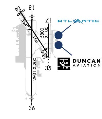
| Lat: N 4051.1 Long: W 09645.5 Elev: 1219 Var: -03 Longest Runway: 12901 | ||
| Clr Del: 120.7 Dept. ATIS: 118.05 Arr. ATIS: 118.05 Ground: 121.9 Tower: 118.5/125.7 | ||
| |||||||||||||||||||||||||||||||||||||||||||||||||||||||||||||||||||||
| |||||||||||||||||||||||||||||||||||||||||||||||||||||||||||||||||||||
| |||||||||||||||||||||||||||||||||||||||||||||||||||||||||||||||||||||
| |||||||||||||||||||||||||||||||||||||||||||||||||||||||||||||||||||||
| Rwy | Rwy | |||||||
| 8649x150 | 8286' | 8649x150 | 8179' | |||||
| 5801x100 | 5801' | 5801x100 | 5801' | |||||
| 12901x200 | 12901' | 111.10 - 177° | 12901x200 | 12901' | 109.90 - 357° | |||
| Runway ID | Single Wheel | Double Wheel | Double Tandem Wheel | Dual Double Wheel |
| 14/32 | 80,000 | 170,000 | 280,000 | N/A |
| 17/35 | 45,000 | 59,000 | N/A | N/A |
| 18/36 | 100,000 | 200,000 | 400,000 | N/A |
| These numbers are Advisory and are not limits. The Airport Manager should have more accurate Weight Limits | ||||
 Airport Diagram might not be current. | |
| Facility Name: | LINCOLN |
| City Name: | LINCOLN |
| County: | LANCASTER |
| State abbrev: | NE |
| State Name: | NEBRASKA |
| Ownership: | PUBLICLY OWNED |
| Use: | OPEN TO THE PUBLIC |
| Owner's Name: | LINCOLN ARPT AUTH |
| Address: | BOX 80407 |
| LINCOLN, NE 68501 | |
| Owner's Phone: | 402-458-2400 |
| Manager's Name: | MR. ANTHONY DUDAS; EXECUTIVE DIRECTOR. |
| Address: | LINCOLN AIRPORT AUTHORITY, P.O. BOX 80407 |
| LINCOLN, NE 68501 | |
| Phone: | 402-458-2400 |
| FAA Region: | CENTRAL |
| FAA Field Office: | NONE |

| Date | Sunrise | Sunset |
|---|---|---|
| 07/14/26 Tuesday | 6:07 | 20:58 |
| 07/15/26 Wednesday | 6:08 | 20:57 |
| 07/16/26 Thursday | 6:09 | 20:57 |
| 07/17/26 Friday | 6:10 | 20:56 |
| 07/18/26 Saturday | 6:10 | 20:56 |
| 07/19/26 Sunday | 6:11 | 20:55 |
| 07/20/26 Monday | 6:12 | 20:54 |
| 07/21/26 Tuesday | 6:13 | 20:53 |
| 07/22/26 Wednesday | 6:14 | 20:53 |
| 07/23/26 Thursday | 6:15 | 20:52 |
| 07/24/26 Friday | 6:16 | 20:51 |
| 07/25/26 Saturday | 6:17 | 20:50 |
| 07/26/26 Sunday | 6:17 | 20:49 |
| 07/27/26 Monday | 6:18 | 20:48 |
| Airport Attendance Schedule | CONTINUOUS |
| Airport Status | OPERATIONAL (This Status can change at any time - please check NOTAMS) |
| Airport Lighting Schedule | WHEN ATCT CLSD, MALSR RWYS 18 & 36 OPR CONSLY ON LOW INTST; ODALS RWY 35 OPR CONSLY ON MED INTST; REIL RWY 14 OPR CONSLY ON LOW INTST; REIL RWY 17 OPR CONSLY ON MED INTST; MIRL RWY 14/32 AND RWY 17/35 OPR CONSLY ON LOW INTST; HIRL RWY 18/36 OPR CONSLY ON MED INTST. VASI RWY 32; PAPI RWYS 14, 17, |
| Airport Storage Available | Tie Downs, Hanger |
| Extra Services Available | Air Freight, Air Ambulance, Avionics, Cargo Handling, Charter, Flight Instruction, Aircraft Rental, Aircraft Sales, Annual Surveying |
| Wind Indicator | YES - (lighted) |
| Control Tower | YES |
| CTAF Frequency | 118.500 |
| Unicom Frequency | 122.950 |
| Rotating Beacon Color | WG |
| Segmented Circle | NO |
| Landing Fee | NO |
| Airport Inspected | FEDERAL - performed by FAA AIRPORTS FIELD PERSONNEL |
| Inspection Date | 03/24/2026 |
| Type of Fuel Available | Grade 100LL, JET A (freeze point -40C) |
| Airframe Repair Service | MAJOR |
| Power Plant Repair Service | MAJOR |
| Latitude | N4051.1 |
| Longitude | W09645.5 (ESTIMATED) |
| Arpt Elevation | 1218ft (SURVEYED) |
| Magnetic Variation | 03E |
| 4 miles NW | of LINCOLN |
| Traffic Pattern Altitude | HVY MIL JET TPA 1781 FT AGL |
| Sectional Chart | OMAHA |
| Operations (Reported) | Yearly | Avg. Daily |
|---|---|---|
| General Aviation Transient | 0 | 0 |
| General Aviation Local | 0 | 0 |
| Air Taxi | 0 | 0 |
| Commerical | 0 | 0 |
| Commuter | 0 | 0 |
| Military | 0 | 0 |
| Aircraft based on Field | |
|---|---|
| General Aviation Singles | 0 |
| General Aviation Multi | 0 |
| Jet Aircraft | 0 |
| General Aviation Helicopters | 0 |
| Military Aircraft | 0 |
| Gliders | 0 |
| Ultralights | 0 |
| FSS on field | NO |
| FSS tie-in | COLUMBUS |
| FSS Phone | 1-800-WX-BRIEF |
| Who issues Notams | LNK |
| Notam D service at airport | YES |
| ARTCC Name | MINNEAPOLIS |
| Airport Certification | AIRPORT RECEIVING SCHEDULED AIR CARRIER SERVICE FROM CARRIERS CERTIFICATED BY THE CIVIL AERONAUTICS BOARD; INDEX C LVL ARFF EQPT PRVDD; FOR ARFF SVC - CTAF. |
| Aircraft Rescue & Firefighting Index | AIRPORT HAS A CERTIFICATE UNDER CFR PART 139 |
| Airport of Entry | No |
| Custom Landing Rights | No |
| Joint Civil/Military | No |
| Military Landing rights | YES |
| NATIONAL PLAN OF INTEGRATED AIRPORT SYSTEMS (NPIAS) |
| GRANT AGREEMENTS UNDER FAAP/ADAP/AIP |
| SURPLUS PROPERTY AGREEMENT UNDER PUBLIC LAW 289 |
| ASSURANCES PURSUANT TO TITLE VI, CIVIL RIGHTS ACT OF 1964 |
| BIRDS INVOF ARPT. |
| ANG: CTC AM OPS 234.65 20 MIN PRIOR TO LDG. |
| ANG: PROVISIONAL PORT OF ENTRY: US CUSTOMS AVBL ONLY WITH 24 HR NOTICE AND ONLY FOR DOD AIRCREW AND DOD DUTY PAX ON TRAVEL ORDERS. CTC COMD POST. SPACE-A US CUSTOMS ENTRY TO THE US AT THIS ARPT LIMITED TO ACTIVE DUTY MILITARY PERSONNEL ON LEAVE (NO DEPENDENTS). |
| ARNG: OPR 1300-2100Z++ TUE-FRI, LTD TRAN MAINT. |
| ARNG: RAMP IS OFFL BUS/PPR TO PRK ARNG RAMP CTC FLT OPS DSN 279-1844, C402-309-1844. |
| ENSURE CORRECT RWY LINEUP. RWY 17/35 IS THE SHRTR, PARL RWY ON E SIDE OF ARPT. |
| ANG: AM OPS DSN 279-1293; C402-309-1293. |
| PPR 24 HRS FOR ACFT PARKING ON THE WEST RAMP - CTC ARPT 402-458-2480. |
| ANG: CTC AM OPS 234.65 FOR BWC. |
| FOR CD WHEN ATCT IS CLSD CTC OMAHA APCH AT 402-682-4395. |
| AF: USAF TMPRY OPS ON WEST RAMP FR APRX SPRING 2021 TO FALL 2022. |
| PPR TO PARK ON ANG RAMP. |
| RWY 18 CALM WIND RWY. |
| RWY 32 APCH HOLDLINE ON SOUTH TWY A. |
| RWY 14/3 2 PCR VALUE: 450/F/B/X/U |
| RWY 17/3 5 PCR VALUE: 140/R/C/W/T |
| RWY 18/3 6 PCR VALUE: 672/R/B/W/U |
Airport Communications & Frequencies:
| ||||||||||||||||||||||||||||||||||||
| Runway: 14 | Runway: 32 | ||
| Mag heading: | 142° | Mag heading: | 322° |
| Rwy Slope: | -.25% Down | Rwy Slope: | .25% Up |
| Approach: | Approach: | ||
| Pattern: | Left Traffic | Pattern: | Left Traffic |
| Markings: | NONPRECISION INSTRUMENT | Markings: | NONPRECISION INSTRUMENT |
| Marking Condition: | GOOD | Marking Condition: | GOOD |
| Arresting Dev: | Arresting Dev: | ||
| Lat & Long: | N4052.0 W09646.2 | Lat. & Long.: | N4050.9 W09645.1 |
| Elev: | 1198.9 ft. MSL | Elev: | 1177.7 ft. MSL |
| TCH: | 48 ft. AGL | TCH: | 54 ft. AGL |
| Visual Glide Path: | 3.00 degrees | Visual Glide Path: | 3.00 degrees |
| Displaced Threshold: | 363 feet | Displaced Threshold: | 470 feet |
| Touchdown Zone: | YES | Touchdown Zone: | YES |
| Touchdown Elev.: | 1199.0 feet | Touchdown Elev.: | 1192.0 feet |
| Visual Glide Slope: | 4-Light PAPI on LEFT side of Runway | Visual Glide Slope: | 4-BOX VASI ON LEFT SIDE OF RUNWAY; VASI UNUSBL BYD 8 DEGS LEFT OF CNTRLN AND 6 DEGS RIGHT OF CNTRLN. |
| RVR Equipment: | RVR Equipment: | ||
| RVV Equipment: | NO | RVV Equipment: | NO |
| Approach Lights: | Approach Lights: | ||
| REIL: | YES | REIL: | NO |
| Centerline Lights: | NO | Centerline Lights: | NO |
| Touchdown lights: | NO | Touchdown lights: | NO |
| Runway Category: | Runway with a Non-precision Approach having visibility minimums greater than 3/4 mile | Runway Category: | Runway with a Non-precision Approach having visibility minimums greater than 3/4 mile |
| Declared Distances: | TORA:8649' TODA:8649' ASDA:8649' LDA:8286' | Declared Distances: | TORA:8649' TODA:8649' ASDA:8286' LDA:7816' |
| Obstructions: | Obstructions: | POLE | |
| Marked: | Marked: | NOT Marked/Lighted | |
| Clearance slope: | 50:1 | Clearance slope: | 38:1; APCH RATIO FM DTHR 49:1. |
| Obstruction height: | Obstruction height: | 59 feet AGL | |
| Dist. from runway: | Dist. from runway: | 2475 feet | |
| Centerline offset: | Centerline offset: | 375 feet right of centerline | |
| Comments: | Comments: |
| Runway: 17 | Runway: 35 | ||
| Mag heading: | 177° | Mag heading: | 357° |
| Rwy Slope: | -.79% Down | Rwy Slope: | .79% Up |
| Approach: | Approach: | ||
| Pattern: | Left Traffic | Pattern: | Right Traffic |
| Markings: | NONPRECISION INSTRUMENT | Markings: | NONPRECISION INSTRUMENT |
| Marking Condition: | GOOD | Marking Condition: | GOOD |
| Arresting Dev: | Arresting Dev: | ||
| Lat & Long: | N4051.7 W09645.0 | Lat. & Long.: | N4050.7 W09645.1 |
| Elev: | 1218.7 ft. MSL | Elev: | 1173.0 ft. MSL |
| TCH: | 44 ft. AGL | TCH: | 30 ft. AGL |
| Visual Glide Path: | 3.00 degrees | Visual Glide Path: | 3.00 degrees |
| Displaced Threshold: | No | Displaced Threshold: | No |
| Touchdown Zone: | YES | Touchdown Zone: | YES |
| Touchdown Elev.: | 1218.7 feet | Touchdown Elev.: | 1196.1 feet |
| Visual Glide Slope: | 4-Light PAPI on LEFT side of Runway | Visual Glide Slope: | 4-Light PAPI on LEFT side of Runway |
| RVR Equipment: | RVR Equipment: | ||
| RVV Equipment: | NO | RVV Equipment: | NO |
| Approach Lights: | Approach Lights: | ODALS - omnidirectional approach lighting system | |
| REIL: | YES | REIL: | NO |
| Centerline Lights: | NO | Centerline Lights: | NO |
| Touchdown lights: | NO | Touchdown lights: | NO |
| Runway Category: | Runway with a Non-precision Approach having visibility minimums greater than 3/4 mile | Runway Category: | Runway with a Visual Approach |
| Declared Distances: | TORA:5800' TODA:5800' ASDA:5400' LDA:5400' | Declared Distances: | TORA:5800' TODA:5800' ASDA:5800' LDA:5800' |
| Runway: 18 | Runway: 36 | ||
| Mag heading: | 177° | Mag heading: | 357° |
| Rwy Slope: | -.16% Down | Rwy Slope: | .16% Up |
| Approach: | ILS | Approach: | ILS |
| Pattern: | Right Traffic | Pattern: | Left Traffic |
| Markings: | PRECISION INSTRUMENT | Markings: | PRECISION INSTRUMENT |
| Marking Condition: | GOOD | Marking Condition: | GOOD |
| Arresting Dev: | Arresting Dev: | ||
| Lat & Long: | N4051.8 W09645.7 | Lat. & Long.: | N4049.7 W09645.7 |
| Elev: | 1195.2 ft. MSL | Elev: | 1174.7 ft. MSL |
| TCH: | 55 ft. AGL | TCH: | 56 ft. AGL |
| Visual Glide Path: | 3.00 degrees | Visual Glide Path: | 3.00 degrees |
| Displaced Threshold: | No | Displaced Threshold: | No |
| Touchdown Zone: | YES | Touchdown Zone: | YES |
| Touchdown Elev.: | 1195.2 feet | Touchdown Elev.: | 1174.7 feet |
| Visual Glide Slope: | 4-Light PAPI on LEFT side of Runway | Visual Glide Slope: | 4-Light PAPI on LEFT side of Runway |
| RVR Equipment: | TOUCHDOWN-ROLLOUT | RVR Equipment: | TOUCHDOWN-ROLLOUT |
| RVV Equipment: | NO | RVV Equipment: | NO |
| Approach Lights: | MALSR - 1,400 foot medium intensity approach lighting system with runway alignment indicator lights | Approach Lights: | MALSR - 1,400 foot medium intensity approach lighting system with runway alignment indicator lights |
| REIL: | NO | REIL: | NO |
| Centerline Lights: | NO | Centerline Lights: | NO |
| Touchdown lights: | NO | Touchdown lights: | NO |
| Runway Category: | Precision Instrument Runway | Runway Category: | Precision Instrument Runway |
| Declared Distances: | TORA:12901' TODA:12901' ASDA:12901' LDA:12901' | Declared Distances: | TORA:12901' TODA:12901' ASDA:12901' LDA:12901' |
Thanks for using FltPlan.com
all rights reserved © 1999-2026 by Flight Plan LLC