
| LINCOLN RGNL/KARL HARDER FIELD LINCOLN CA |
| |
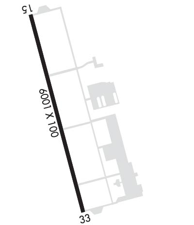
| Lat: N 3854.6 Long: W 12121.1 Elev: 121 Var: -14 Longest Runway: 6001 | ||
| AWOS: 124.25 CTAF: 123.0 | ||
| ||||||||||||||||||||||||||||||||||||||||||||
| ||||||||||||||||||||||||||||||||||||||||||||
| ||||||||||||||||||||||||||||||||||||||||||||
| Rwy | Rwy | |||||||
| 6001x100 | 6001' | 108.75 - 151° | 6001x100 | 6001' | ||||
| Runway ID | Single Wheel | Double Wheel | Double Tandem Wheel | Dual Double Wheel |
| 15/33 | 30,000 | 60,000 | N/A | N/A |
| H1 | N/A | N/A | N/A | N/A |
| These numbers are Advisory and are not limits. The Airport Manager should have more accurate Weight Limits | ||||
 Airport Diagram might not be current. | |
| Facility Name: | LINCOLN RGNL/KARL HARDER FLD |
| City Name: | LINCOLN |
| County: | PLACER |
| State abbrev: | CA |
| State Name: | CALIFORNIA |
| Ownership: | PUBLICLY OWNED |
| Use: | OPEN TO THE PUBLIC |
| Owner's Name: | CITY OF LINCOLN |
| Address: | 600 6TH STREET |
| LINCOLN, CA 95648 | |
| Owner's Phone: | (916) 434-2450 |
| Manager's Name: | RICHARD SPINALE; EMAIL: RSPINALE@LINCOLNCA.GOV. |
| Address: | 600 SIXTH STREET |
| LINCOLN, CA 95648 | |
| Phone: | 916-645-3443 |
| FAA Region: | WESTERN-PACIFIC |
| FAA Field Office: | SFO |
| Date | Sunrise | Sunset |
|---|---|---|
| 06/07/26 Sunday | 5:40 | 20:29 |
| 06/08/26 Monday | 5:40 | 20:29 |
| 06/09/26 Tuesday | 5:40 | 20:30 |
| 06/10/26 Wednesday | 5:40 | 20:30 |
| 06/11/26 Thursday | 5:39 | 20:31 |
| 06/12/26 Friday | 5:39 | 20:31 |
| 06/13/26 Saturday | 5:39 | 20:32 |
| 06/14/26 Sunday | 5:39 | 20:32 |
| 06/15/26 Monday | 5:39 | 20:32 |
| 06/16/26 Tuesday | 5:39 | 20:33 |
| 06/17/26 Wednesday | 5:40 | 20:33 |
| 06/18/26 Thursday | 5:40 | 20:33 |
| 06/19/26 Friday | 5:40 | 20:34 |
| 06/20/26 Saturday | 5:40 | 20:34 |
| Airport Attendance Schedule | MON-FRI 0630 - 1500 |
| Airport Status | OPERATIONAL (This Status can change at any time - please check NOTAMS) |
| Airport Lighting Schedule | ACTVT MALSR RWY 15; MIRL RWY 15/33, HELI PERIMETER LGTS - CTAF. PAPI RWYS 15 & 33 TURNED ON DURING DALGT HRS, AFTER DARK ACTVT - CTAF. |
| Airport Storage Available | Tie Downs |
| Extra Services Available | Avionics, Charter, Flight Instruction, Aircraft Rental, Aircraft Sales |
| Wind Indicator | YES - (lighted) |
| Control Tower | NO |
| CTAF Frequency | 123.000 |
| Unicom Frequency | 123.000 |
| Rotating Beacon Color | WG |
| Segmented Circle | YES |
| Landing Fee | NO |
| Airport Inspected | STATE - performed by STATE AERONAUTICAL PERSONNEL |
| Inspection Date | 01/24/2025 |
| Type of Fuel Available | Grade 100LL, JET A (freeze point -40C); -10FOR JET A AND 100LL FUEL TRUCK CTC (916) 257-4854, 0600-1700. SELF SVC FUEL AVBL 24 HRS. |
| Airframe Repair Service | MAJOR |
| Power Plant Repair Service | MAJOR |
| Latitude | N3854.6 |
| Longitude | W12121.1 (ESTIMATED) |
| Arpt Elevation | 121ft (SURVEYED) |
| Magnetic Variation | 14E |
| 3 miles W | of LINCOLN |
| Traffic Pattern Altitude | |
| Sectional Chart | SAN FRANCISCO |
| Operations (Reported) | Yearly | Avg. Daily |
|---|---|---|
| General Aviation Transient | 0 | 0 |
| General Aviation Local | 0 | 0 |
| Air Taxi | 0 | 0 |
| Commerical | 0 | 0 |
| Commuter | 0 | 0 |
| Military | 0 | 0 |
| Aircraft based on Field | |
|---|---|
| General Aviation Singles | 0 |
| General Aviation Multi | 0 |
| Jet Aircraft | 0 |
| General Aviation Helicopters | 0 |
| Military Aircraft | 0 |
| Gliders | 0 |
| Ultralights | 0 |
| FSS on field | NO |
| FSS tie-in | RANCHO MURIETA |
| FSS Phone | 1-800-WX-BRIEF |
| Who issues Notams | RIU |
| Notam D service at airport | YES |
| ARTCC Name | OAKLAND |
| Airport Certification | |
| Aircraft Rescue & Firefighting Index | None |
| Airport of Entry | No |
| Custom Landing Rights | No |
| Joint Civil/Military | No |
| Military Landing rights | YES |
| NATIONAL PLAN OF INTEGRATED AIRPORT SYSTEMS (NPIAS) |
| GRANT AGREEMENTS UNDER FAAP/ADAP/AIP |
| SURPLUS PROPERTY AGREEMENT UNDER REGULATION 16-WAA |
| ASSURANCES PURSUANT TO TITLE VI, CIVIL RIGHTS ACT OF 1964 |
| FOR CD CTC NORCAL APCH AT 916-361-6874. |
| PWRD PRCHT ACT SW QUAD OF ARPT. |
| RWY 15 RY 15 CALM WND RY. |
Airport Communications & Frequencies:
| ||||||||||||||
| Runway: 15 | Runway: 33 | ||
| Mag heading: | 151° | Mag heading: | 331° |
| Rwy Slope: | .00% Down | Rwy Slope: | .00% Up |
| Approach: | ILS/DME | Approach: | |
| Pattern: | Left Traffic | Pattern: | Left Traffic |
| Markings: | PRECISION INSTRUMENT | Markings: | NONPRECISION INSTRUMENT |
| Marking Condition: | GOOD | Marking Condition: | GOOD |
| Arresting Dev: | Arresting Dev: | ||
| Lat & Long: | N3855.0 W12121.2 | Lat. & Long.: | N3854.1 W12120.9 |
| Elev: | 119.8 ft. MSL | Elev: | 119.7 ft. MSL |
| TCH: | 44 ft. AGL | TCH: | 29 ft. AGL |
| Visual Glide Path: | 3.00 degrees | Visual Glide Path: | 3.00 degrees |
| Displaced Threshold: | No | Displaced Threshold: | No |
| Touchdown Zone: | YES | Touchdown Zone: | YES |
| Touchdown Elev.: | 121.4 feet | Touchdown Elev.: | 120.7 feet |
| Visual Glide Slope: | 4-Light PAPI on LEFT side of Runway | Visual Glide Slope: | 4-Light PAPI on LEFT side of Runway |
| RVR Equipment: | RVR Equipment: | ||
| RVV Equipment: | NO | RVV Equipment: | NO |
| Approach Lights: | MALSR - 1,400 foot medium intensity approach lighting system with runway alignment indicator lights | Approach Lights: | |
| REIL: | NO | REIL: | NO |
| Centerline Lights: | NO | Centerline Lights: | NO |
| Touchdown lights: | NO | Touchdown lights: | NO |
| Runway Category: | Precision Instrument Runway | Runway Category: | Runway with a Non-precision Approach having visibility minimums greater than 3/4 mile |
| Declared Distances: | Declared Distances: | ||
| Obstructions: | TREE | Obstructions: | TREES |
| Marked: | NOT Marked/Lighted | Marked: | NOT Marked/Lighted |
| Clearance slope: | 32:1 | Clearance slope: | 35:1 |
| Obstruction height: | 25 feet AGL | Obstruction height: | 40 feet AGL |
| Dist. from runway: | 1000 feet | Dist. from runway: | 1600 feet |
| Centerline offset: | Centerline offset: | ||
| Comments: | Comments: |
Thanks for using FltPlan.com
all rights reserved © 1999-2026 by Flight Plan LLC
