| LEBANON MUNI LEBANON NH |
| |
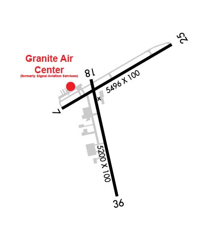
| Lat: N 4337.6 Long: W 07218.3 Elev: 603 Var: +16 Longest Runway: 5496 | ||
| Dept. ATIS: 118.65 Arr. ATIS: 118.65 AWOS: 118.65 Ground: 121.6 Tower: 125.95 | ||
| |||||||||||||||||||||||||||||||||||||||||||||||||||||||||||||||||||||
| |||||||||||||||||||||||||||||||||||||||||||||||||||||||||||||||||||||
| |||||||||||||||||||||||||||||||||||||||||||||||||||||||||||||||||||||
| Rwy | Rwy | |||||||
| 5496x100 | 5496' | 5496x100 | 5496' | |||||
| 5200x100 | 5200' | 111.90 - 187° | 5200x100 | 5200' | ||||
| Runway ID | Single Wheel | Double Wheel | Double Tandem Wheel | Dual Double Wheel |
| 07/25 | 42,000 | 60,000 | N/A | N/A |
| 18/36 | 42,000 | 48,000 | N/A | N/A |
| These numbers are Advisory and are not limits. The Airport Manager should have more accurate Weight Limits | ||||
 Airport Diagram might not be current. | |
| Facility Name: | LEBANON MUNI |
| City Name: | LEBANON |
| County: | GRAFTON |
| State abbrev: | NH |
| State Name: | NEW HAMPSHIRE |
| Ownership: | PUBLICLY OWNED |
| Use: | OPEN TO THE PUBLIC |
| Owner's Name: | CITY OF LEBANON |
| Address: | 51 N PARK ST |
| LEBANON, NH 03766 | |
| Owner's Phone: | 603-298-8878 |
| Manager's Name: | CARL GROSS |
| Address: | 5 AIRPARK RD |
| WEST LEBANON, NH 03784 | |
| Phone: | 603-298-8878 |
| FAA Region: | NEW ENGLAND |
| FAA Field Office: | NONE |
| Date | Sunrise | Sunset |
|---|---|---|
| 07/20/26 Monday | 5:26 | 20:25 |
| 07/21/26 Tuesday | 5:27 | 20:24 |
| 07/22/26 Wednesday | 5:28 | 20:23 |
| 07/23/26 Thursday | 5:29 | 20:22 |
| 07/24/26 Friday | 5:30 | 20:21 |
| 07/25/26 Saturday | 5:31 | 20:20 |
| 07/26/26 Sunday | 5:32 | 20:19 |
| 07/27/26 Monday | 5:33 | 20:18 |
| 07/28/26 Tuesday | 5:34 | 20:17 |
| 07/29/26 Wednesday | 5:35 | 20:16 |
| 07/30/26 Thursday | 5:36 | 20:15 |
| 07/31/26 Friday | 5:37 | 20:14 |
| 08/01/26 Saturday | 5:38 | 20:12 |
| 08/02/26 Sunday | 5:39 | 20:11 |
| Airport Attendance Schedule | 7 Days A Week 0600-2200 |
| Airport Status | OPERATIONAL (This Status can change at any time - please check NOTAMS) |
| Airport Lighting Schedule | ACTVT REIL RWY 07 & 25; PAPI RWY 07, 25 & 36; MIRL RWY 07/25; HIRL RWY 18/36 - CTAF. |
| Airport Storage Available | Tie Downs, Hanger |
| Extra Services Available | Air Ambulance, Charter, Flight Instruction, Annual Surveying |
| Wind Indicator | YES - (lighted) |
| Control Tower | YES |
| CTAF Frequency | 125.950 |
| Unicom Frequency | 122.950 |
| Rotating Beacon Color | WG |
| Segmented Circle | YES |
| Landing Fee | YES; LDG FEES EXCP FOR NON-COML SNGL ENG. |
| Airport Inspected | FEDERAL - performed by STATE AERONAUTICAL PERSONNEL |
| Inspection Date | 07/19/2024 |
| Type of Fuel Available | Grade 100LL, JET A (freeze point -40C); -A FOR FUEL AFT HRS CALL 603-298-6555. |
| Airframe Repair Service | MAJOR |
| Power Plant Repair Service | MAJOR |
| Latitude | N4337.6 |
| Longitude | W07218.3 (ESTIMATED) |
| Arpt Elevation | 603ft (SURVEYED) |
| Magnetic Variation | 16W |
| 3 miles W | of LEBANON |
| Traffic Pattern Altitude | |
| Sectional Chart | NEW YORK |
| Operations (Reported) | Yearly | Avg. Daily |
|---|---|---|
| General Aviation Transient | 0 | 0 |
| General Aviation Local | 0 | 0 |
| Air Taxi | 0 | 0 |
| Commerical | 0 | 0 |
| Commuter | 0 | 0 |
| Military | 0 | 0 |
| Aircraft based on Field | |
|---|---|
| General Aviation Singles | 0 |
| General Aviation Multi | 0 |
| Jet Aircraft | 0 |
| General Aviation Helicopters | 0 |
| Military Aircraft | 0 |
| Gliders | 0 |
| Ultralights | 0 |
| FSS on field | NO |
| FSS tie-in | BANGOR |
| FSS Phone | 1-800-WX-BRIEF |
| Who issues Notams | LEB |
| Notam D service at airport | YES |
| ARTCC Name | BOSTON |
| Airport Certification | |
| Aircraft Rescue & Firefighting Index | None |
| Airport of Entry | No |
| Custom Landing Rights | No |
| Joint Civil/Military | No |
| Military Landing rights | YES |
| NATIONAL PLAN OF INTEGRATED AIRPORT SYSTEMS (NPIAS) |
| GRANT AGREEMENTS UNDER FAAP/ADAP/AIP |
| ASSURANCES PURSUANT TO TITLE VI, CIVIL RIGHTS ACT OF 1964 |
| AGREEMENT UNDER DLAND OR DCLA HAS EXPIRED. |
| THIS AIRPORT HAS BEEN SURVEYED BY THE NATIONAL GEODETIC SURVEY. |
| TREES 5600 FT E OF ARPT, ELEV 1253 FT; TREES 6700 FT E OF ARPT, ELEV 1275 FT; TREES INDCD ARE OBSTN LGTD. |
| OCNL WILDLIFE ACT ON & NR ARPT. |
| HANG GLDR OPS INVOF MT ASCUTNEY, VT 20 MI SW LEB SFC-8000 FT DAYS. |
| NO PLAS OR TGLS 0000-0700. |
| NOISE ABATEMENT PROCS IN EFCT, CTC AMGR. ALL ARR/DEP ACFT FLW MANUFACTURER'S RCMDD PROC FOR QUIET OPN & MNM NOISE. |
| COLD TEMPERATURE AIRPORT. ALTITUDE CORRECTION REQUIRED AT OR BELOW -19C. |
| FOR CD IF TWR CLSD & UNA TO CTC FSS FREQ, CTC BOSTON ARTCC AT 603-879-6859. |
| HOT AIR BALLOON ACT 8.6 NM W OF ARPT. |
Airport Communications & Frequencies:
| |||||||||||||||||
| Runway: 07 | Runway: 25 | ||
| Mag heading: | 75° | Mag heading: | 255° |
| Rwy Slope: | .21% Up | Rwy Slope: | -.21% Down |
| Approach: | Approach: | ||
| Pattern: | Left Traffic | Pattern: | Left Traffic |
| Markings: | NONPRECISION INSTRUMENT | Markings: | NONPRECISION INSTRUMENT |
| Marking Condition: | GOOD | Marking Condition: | GOOD |
| Arresting Dev: | Arresting Dev: | ||
| Lat & Long: | N4337.6 W07218.7 | Lat. & Long.: | N4338.0 W07217.7 |
| Elev: | 562.5 ft. MSL | Elev: | 573.8 ft. MSL |
| TCH: | 50 ft. AGL | TCH: | 51 ft. AGL |
| Visual Glide Path: | 4.00 degrees | Visual Glide Path: | 4.00 degrees |
| Displaced Threshold: | No | Displaced Threshold: | No |
| Touchdown Zone: | YES | Touchdown Zone: | YES |
| Touchdown Elev.: | 564.1 feet | Touchdown Elev.: | 573.9 feet |
| Visual Glide Slope: | 4-Light PAPI on LEFT side of Runway | Visual Glide Slope: | 4-Light PAPI on RIGHT side of Runway |
| RVR Equipment: | RVR Equipment: | ||
| RVV Equipment: | NO | RVV Equipment: | NO |
| Approach Lights: | Approach Lights: | ||
| REIL: | YES | REIL: | YES |
| Centerline Lights: | NO | Centerline Lights: | NO |
| Touchdown lights: | NO | Touchdown lights: | NO |
| Runway Category: | Runway with a Non-precision Approach having visibility minimums greater than 3/4 mile | Runway Category: | Runway with a Non-precision Approach having visibility minimums greater than 3/4 mile |
| Declared Distances: | Declared Distances: | ||
| Obstructions: | TREE | Obstructions: | TREE |
| Marked: | NOT Marked/Lighted | Marked: | NOT Marked/Lighted |
| Clearance slope: | 7:1 | Clearance slope: | 4:1 |
| Obstruction height: | 16 feet AGL | Obstruction height: | 74 feet AGL |
| Dist. from runway: | 316 feet | Dist. from runway: | 537 feet |
| Centerline offset: | 213 left of centerline | Centerline offset: | 286 feet left of centerline |
| Comments: | Comments: | 30 FT TREE 145 FT FM RWY END, 179 FT RIGHT. |
| Runway: 18 | Runway: 36 | ||
| Mag heading: | 184° | Mag heading: | 4° |
| Rwy Slope: | .77% Up | Rwy Slope: | -.77% Down |
| Approach: | ILS/DME | Approach: | |
| Pattern: | Left Traffic | Pattern: | Left Traffic |
| Markings: | PRECISION INSTRUMENT | Markings: | PRECISION INSTRUMENT |
| Marking Condition: | GOOD | Marking Condition: | GOOD |
| Arresting Dev: | Arresting Dev: | ||
| Lat & Long: | N4337.8 W07218.4 | Lat. & Long.: | N4336.9 W07218.2 |
| Elev: | 563.5 ft. MSL | Elev: | 603.3 ft. MSL |
| TCH: | TCH: | 34 ft. AGL | |
| Visual Glide Path: | Visual Glide Path: | 3.75 degrees | |
| Displaced Threshold: | No | Displaced Threshold: | No |
| Touchdown Zone: | YES | Touchdown Zone: | YES |
| Touchdown Elev.: | 572.7 feet | Touchdown Elev.: | 603.3 feet |
| Visual Glide Slope: | Visual Glide Slope: | 4-Light PAPI on LEFT side of Runway | |
| RVR Equipment: | RVR Equipment: | ||
| RVV Equipment: | NO | RVV Equipment: | NO |
| Approach Lights: | Approach Lights: | ||
| REIL: | YES | REIL: | NO |
| Centerline Lights: | NO | Centerline Lights: | NO |
| Touchdown lights: | NO | Touchdown lights: | NO |
| Runway Category: | Precision Instrument Runway | Runway Category: | Runway with a Non-precision Approach having visibility minimums greater than 3/4 mile |
| Declared Distances: | Declared Distances: | ||
| Obstructions: | TREES | Obstructions: | TREES; TREES 4000 FT W OF EOR, 970 FT MSL, OBST LGTD. TREES 1500 FT SW OF EOR, 800 FT MSL, OBST LGTD. |
| Marked: | NOT Marked/Lighted | Marked: | NOT Marked/Lighted |
| Clearance slope: | 14:1 | Clearance slope: | 4:1 |
| Obstruction height: | 11 feet AGL | Obstruction height: | 107 feet AGL |
| Dist. from runway: | 355 feet | Dist. from runway: | 667 feet |
| Centerline offset: | 331 right of centerline | Centerline offset: | 521 feet left of centerline |
| Comments: | FENCE 125 FT FM RWY END, 425 FT RIGHT. | Comments: |
Thanks for using FltPlan.com
all rights reserved © 1999-2026 by Flight Plan LLC